Downloaded 18 times


![2384 J. C. Home et al
lOOi
SCALES
ORTHOQUARTZITE TTT ROOTING
SANDSTOME
->./- BURROW STRUCTURE
DARK-GRAY SHALE
• AND SILTSTONE Mjr- CROSS - BEDS
RED A N D GREEN ^— RIPPLES ISO
SHALE FEET
WAVE TRAINS MARSH
BARRIER
ISLAND
EBB-TIDAL
DELTA
FLOOD-TIDAL
DELTA SANDSTONE
OFFSHORE] LAGOONAL
TIDAL CHANNEL
SHALE SANDSTONE SHALE
SHORE FACE
SANDSTONE FESTOON CROSS-BEDS
ORTHOQUARTZITE
PLANAR CROSS-BEDS
GRAY SHALE
RIPPLES
ggjj RED A N D GREEN SHALE
METERS
g ^ LIMESTONE
— COAL
TTTT ROOTING KILOMETERS
-^^ BURROW STRUCTURE
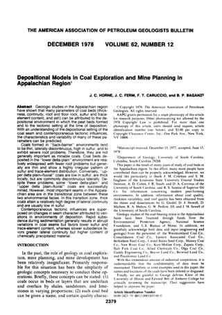
FIG. 3—A, Back-barrier deposits including storm washovers, tidal channels, and flood-tidal delta exposed in clay
pit along Interstate 64 west of Olive Hill, Kentucky. Side panels based on greater than 95% exposure (Home and
Ferm, 1976). B, Barrier and back-barrier environments including tidal channels and flood-tidal deltas exposed in
Carter Caves State Park region near Olive Hill, Kentucky (Home and Ferm, 1976).](https://image.slidesharecdn.com/23790-130118092200-phpapp02/85/23790-6-320.jpg)


![2394 J. C. Home et al
CREVASSE SWAMP
SPLAY
LEVEE
POINT BAR
~~] SANDSTONE 100
I ] SANDSTONE AND SILTSTONE
3 0Ia F E 5ol
ET
FEET 50 SCALES
^ ^ SHALE
L
— COAL
r7Tf ROOTING METERS
0 1000 2000
~-^ BURROW STRUCTURE
FEET
^ MARINE FOSSIL
^5?? BEDDING PLANES
V>^ TROUGH CROSS-BEDS
FIG. 14—Reconstruction of transitional lower delta-plain environments as exposed along U.S. Highway 23 near
Sitka, Kentucky. Side panels based on greater than 70% exposure (Home and Perm, 1976).
On a regional scale, depositional models can be By contrast, in river-dominated lower delta-
used to predict the trends of coal bodies. These plain deposits of the Appalachian Carboniferous,
models are useful in an initial phase of coal explo- the coal bodies are elongate parallel with deposi-
ration. Moreover, locally, they permit a detailed tional dip. This trend exists because the only sites
understanding of variations in coal thickness and where peat swamps can develop are on the nar-
lateral continuity that can aid in mine planning row, poorly developed levees along the distribu-
and development. tary channels. These river-dominated lower delta-
Regionally, back-barrier coal bodies formed plain channels generally are straight and rapidly
landward of contemporaneous or preexisting bar- prograde seaward in the direction of depositional
rier systems. The coal swamps developed on plat- dip. For this reason, the coals that develop in this
forms that evolved as the result of infilling of the environment are continuous laterally in the direc-
lagoons behind the barriers. Coexisting and post- tion of depositional dip but discontinuous parallel
depositional tidal channels may modify the back- with depositional strike, being interrupted by in-
barrier coals into pod-shaped bodies. However, terdistributary bay-fill deposits. These seams
the trend of these pod-shaped seams parallels the commonly are relatively thin and contain numer-
trend of the associated barrier systems, and bar- ous splits caused by crevasse splays that breached
riers, most commonly, are elongate parallel with the poorly developed levees along the distributary
depositional strike. channels.](https://image.slidesharecdn.com/23790-130118092200-phpapp02/85/23790-16-320.jpg)


![2398 J. C. Home et al
LEGEND
CZ] SANDSTONE
SHALE AND SILTSTONE
COAL
TTf ROOTS 360 0 500 1000
< ^ DIRECTION OF PALEOCURRENTS
FIG. 18—Localization and deflection of channeling along Blaine-Walbridge fault south of Louisa, Kentucky.
Side panels based on greater than 60% exposure (Home et al, 1976a).
mulated landward (south) of a barrier system ting (Fig. 19). The coarsening-upward sequence
trending from east-northeast to west-southwest that was deposited over the preexisting coal (front
(Galloway, 1972; Robinson, 1975). The trend of panels. Fig. 20) formed as a result of the infilling
this back-barrier coal body parallels closely that of the lagoonal area landward of the associated
of the associated barrier system, although it is ab- barrier system. As the lagoonal area filled with
sent in places owing to concomitant and later sediment, tidal flats (flasered siltstone and sand-
tidal channels that produced "want areas" (areas stone) and salt marshes became established be-
of little or no coal). Thus, the Beckley coal be- tween intervening tidal channels (upper surface,
haves as other back-barrier coals with respect to Fig. 20A). This setting provided the topography
coal-body shape and regional trend, and present upon which the subsequent coal swamp formed.
and future exploration programs should be de- Initially a freshwater marsh and/or swamp de-
signed to take advantage of these characteristics. veloped on the high areas over the previous salt-
At the lease-tract level (15,000 acres; 6,000 ha., marsh surface and eventually spread over most of
or less), an understanding of coal-thickness varia- the area. As plant growth continued, the smaller
tions is important economically. To depict the in- channels and the upper parts of the larger chan-
fluence depositional environments exert in con- nels became clogged with organic material, and
trolling coal-thickness variations, the details of a only the major tidal channels continued to re-
mined-out area of the Beckley coal were used main open (Fig. 20B). Consequently, the thick-
(Fig. 20). ness variations in the resultant coal deposit reflect
Regionally, this mined-out area of the Beckley very closely the influence of the preexisting depo-
coal is situated in a back-barrier depositional set- sitional topography, with the thicker coal occur-](https://image.slidesharecdn.com/23790-130118092200-phpapp02/85/23790-20-320.jpg)


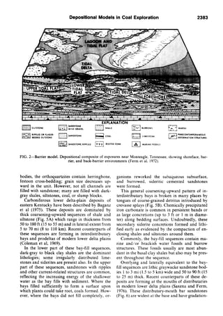
![Depositional Models in Coal Exploration 2403
shown in Figure 23. That the detrital sediment nous clastic sediment, the sulfur content decreas-
was introduced early and shielded the coal from es to less than 1%.
the marine to brackish waters is demonstrated by This example demonstrates the importance of
the fact that the deposits of these waters (the splay deposits in the formation of pockets of low-
limestone and black shale) overlie the terrigenous sulfur coal of sufficient areal extent to be eco-
clastic rocks. This configuration indicates that the nomic in the lower delta-plain setting, normally a
detrital influx occurred before or during marine high-sulfur coal realm. Because splay deposits
inundation. form adjacent to the distributary channels in this
Figure 24 is a reconstruction of the deposi- depositional setting, drilling programs should be
tional setting immediately after the formation of devised to define these features. In this manner,
coal X. It is based on data related to lithologic the areas of the lower delta plain with the greatest
and sediment-thickness variations. These data potential for low-sulfur coal can be delineated.
suggest that the levees of a distributary channel in The relations shown in this example illustrate
the southwestern part of the area were breached the closely parallel distributions of coals with dis-
several times forming large splay deposits in the seminated pyritic sulfur and roof rock of marine
north and east over the coal and into the inter- to brackish origin. Moreover, when terrigenous
vening interdistributary bay. In areas removed clastic sediment is introduced early and is of suf-
from this detrital influx, fossiUferous limestone ficient thickness, the sulfur content in the under-
and black shale were deposited from the marine lying coal remains low. With a knowledge of
to brackish waters of the bay. these characteristics and an understanding of the
Figure 25 illustrates the distribution of the sul- depositional setting, exploration programs can be
fur in coal X that cannot be removed in the 1.50- designed to outline areas of low-sulfur coal in
density sink fraction of washability tests. As ex- what is most commonly a high-sulfur coal prov-
pected, the coal in the eastern part of the area, ince.
where it is overlain by roof rock of marine to
brackish origin, is high in sulfur (greater than 2%) ROOF CONDITIONS
with most of the pyritic sulfur in the form of In the mines of southern West Virginia and
disseminated framboids. On the west and south eastern Kentucky, roof quality is dependent on
where the coal is overlain by the wedge of terrige- the interrelations of rock types, syndepositional
SCALES
1 T
miles
0 5
kilometers
pnqq LIMESTONE AND
^ 3 BLACK SHALE
^ ^ Otf-IOft
I I lOft-20Jt
[ ] greater than 20 ft
—^— line of cross section
FIG. 23—Thickness of terrigenous clastic wedge of sediment between coal X and overlying marine limestone and
black shale. Location of cross section in Figure 22 shown by heavy line.](https://image.slidesharecdn.com/23790-130118092200-phpapp02/85/23790-25-320.jpg)
![2404 J. C. Home et al
SCALES
0 5
kilomalars
DEPOSITIONAL
ENVIRONMENTS
OF ROOF ROCK
(
N
FIG. 24—Reconstruction of depositional setting immediately after formation of coal X. Diagram is based on data
related to lithologic and sediment-thickness variations.
SCALE
0 1 2 3
milM N
0 S
kilomatars
SULFUR PERCENT
1 1 iMslhanl
E '2
S 2 3
ma 4
[•*'] gr«al«r than 4
FIG. 25—Distribution of sulfur in coal X that cannot be removed in 1.50-density sink fraction of washability tests.](https://image.slidesharecdn.com/23790-130118092200-phpapp02/85/23790-26-320.jpg)


The document discusses depositional models for coal exploration and mine planning in the Appalachian region. It finds that the depositional environment of coal beds strongly influences characteristics like thickness, continuity, roof conditions, and coal quality. Coals formed in back-barrier environments tend to be thin, discontinuous, high in sulfur, and have severe roof problems. Coals in the lower delta plain are more widespread but also thin and show irregular sulfur distribution. Coals in the upper delta plain-fluvial environment are thicker, lower in sulfur, but often discontinuous. Most important coals in the region formed in the transitional zone between the lower and upper delta plains, where coals can be thick and laterally continuous with low


![Evaluaciones finales 2010[2]](https://cdn.slidesharecdn.com/ss_thumbnails/evaluacionesfinales20102-101101192022-phpapp02-thumbnail.jpg?width=640&height=640&fit=bounds)