A poster for the Young Ecologists Talk and Interact Conference 2016 explaining my research and results on status of fishing cats in the central terai landscape of India
This document summarizes a 2013 survey of prey populations in Kuno Wildlife Sanctuary in Madhya Pradesh, India. Chital were found to be the most abundant prey species with a density estimate of 69.36/km2. Other prey densities estimated included sambar at 4.85/km2, nilgai at 3.92/km2, and wild pig at 3.05/km2. Using estimated densities and biomass calculations, the total biomass in the sanctuary was estimated to be 3657.97 kg/km2. Analysis showed that the chital population has been increasing exponentially since 2005 at a realized growth rate of 0.35, close to the intrinsic growth rate, suggesting good management
The document summarizes a study on the conservation status of the Indian rock python in Deva Vatala National Park, Azad Jammu and Kashmir, Pakistan from 2009-September 2009. Key findings include:
- The python was distributed across four localities within the park with a total estimated adult population of 27. Population density was highest in Chumb.
- Sightings were most common in July and August and during the day. Active dens were usually located near water sources.
- Major human-python conflicts involved livestock depredation, mostly of goats. Barmala had the highest rate of depredation. Depredation peaked in July-September.
1. The study compared vertebrate diversity and abundance between paddocks under medium and heavy cattle stocking rates in northern Queensland.
2. Overall, medium stocking rate paddocks tended to have lower vertebrate abundances but higher diversity, though many differences were not statistically significant due to small sample sizes.
3. Bird and reptile communities differed substantially between treatments. Medium stocking rate paddocks supported a more diverse bird community including woodland species, while heavy stocking rate paddocks favored more generalist bird species and had higher skink abundances.
This document summarizes a study that aimed to map mangrove species in the Seychelles using remote sensing techniques. The study area was Port Launay wetland on Mahe island, which contains seven mangrove species. Field data was collected using GPS to record species locations and analyze spatial patterns. A Pleiades satellite image was analyzed to classify and map the mangrove species distributions. Issues encountered included tidal access limitations and canopy cover obscuring understory species. The analysis will produce a final mangrove species classification map and provide methodology for future remote sensing wetland studies.
This study examined whether native or invasive species were more likely to repopulate areas after a prescribed burn, which are used for fire prevention. Researchers sampled reptiles and amphibians using quadrats in burned and unburned sites in a Florida nature preserve. In the burned sites, they found slightly more invasive than native species. However, statistical analysis found this difference was not significant and likely due to chance. The results suggest prescribed burns do not favor repopulation by either native or invasive species.
Guerreiro (2014). Biodiversity distribution in the western Sahara-Sahel the r...Ricardo Guerreiro
This document provides background information on a fieldwork internship conducted in North-West Africa to study biodiversity distribution patterns. The internship involved sampling amphibians and reptiles across five ecoregions in Morocco, Mauritania and Mali over 48 days. A total of 47 taxa were found with diversity increasing from north to south. Analyses of niche breadth for 11 taxa showed environmental variation impacts distribution. Distribution of four gecko species was evaluated against environmental factors using GIS, finding preferences for different temperature ranges between closely related species. Overall biodiversity follows a north-south precipitation gradient, and there are apparent ecological niche differences between Tarentola gecko taxa.
Dr. Stephen Ambrose has over 31 years of experience in ecological research and management, specializing in bird ecology. He has a Ph.D. in Zoology from the University of Western Australia and has worked as a Principal Ornithologist for Ambrose Ecological Services Pty Ltd for 17 years, conducting bird population monitoring and impact assessments. He has also held roles at Birdlife Australia and taught at the University of New England and Australian National University. Dr. Ambrose has extensive experience designing environmental management plans and evaluating their effectiveness in protecting bird populations.
Genetic Variability for yield in Maize (Zea mays l.) inbred linesFekaduKorsa
This document summarizes an MSc thesis that studied genetic variability in maize inbred lines in central Ethiopia. 25 maize inbred lines were evaluated in a 5x5 triple lattice design trial. A number of agronomic traits were measured including days to tasseling/silking, plant/ear height, leaf characteristics, tassel/ear traits, yield components and grain yield. Analysis of variance showed significant genetic variability for most traits. Estimates of variance components, phenotypic and genotypic coefficients of variation, heritability and genetic advance were also calculated to understand the genetic potential of the lines for selection and breeding. The study provides useful information on the nature and extent of genetic diversity present in the maize in
Carbon Stocks Estimation in South East Sulawesi Tropical Forest, Indonesia, u...ijceronline
This document summarizes a study that estimated carbon stocks in a tropical forest in Southeast Sulawesi, Indonesia using Polarimetric Interferometry Synthetic Aperture Radar (PolInSAR). Two ALOS PALSAR images with a 46 day temporal baseline were processed to form a Random Volume over Ground model and optimize coherence. Field measurements of tree heights and diameters were converted to carbon stock volumes using allometric equations. The resulting forest heights and carbon stocks from PolInSAR inversion correlated positively with ground measurements.
Length Frequency Distribution, Length-Weight Relationship and Condition Facto...paperpublications3
Abstract: Length –Frequency Distribution, Length – Weight relationship and condition factor of Pomadasys jubelini from the Lagos lagoon were investigated for 6months in order to study the growth pattern and wellbeing of P.jubelini. A total of 305 specimens of P.jubelini were purchased from local fisher-folks on landing sites at different locations within the Lagos lagoon ( Majidun, Makoko, Ibese, Bayeiku) from January 2012 to June 2012 and used for this study. Their Total length ranging from 12cm to 29.5cm and body weight ranged from 21.3g to 367g. The frequency distribution showed a polymodal distribution of P.jubelini. The size class of 18.0cm to 20.9cm (TL) was more abundant. The length weight relationship was determined by regression coefficient equation Log W= -1.8357+2.9628LogL (n =305, r = 0.9213). P.jubelini showed negative allometric growth (b= 2.96). The mean condition factor 1.31, indicates that P.jubelini were in good condition in the lagoon. The result from this study is relevant for fishery management and stock assessment studies of P.jubelini from the Lagos lagoon.
Assessing mangrove deforestation using pixel-based image: a machine learning ...journalBEEI
1. The document assesses mangrove deforestation using machine learning algorithms applied to pixel-based images. It examines random forest (RF), support vector machine (SVM), decision tree (DT), and object-based nearest neighbors algorithms to classify mangrove forests in seven provinces in Thailand's Gulf of Thailand.
2. SVM with a radial basis function resulted in an overall accuracy of 96.83%. RF performed better than other algorithms when orthophotography was not available.
3. The study aims to provide features of tree cover loss, above-ground carbon dioxide emissions, and above-ground biomass loss for 2001-2019 using the machine learning algorithms.
This document describes the development of a food web matrix for the Gulf of Mexico based on combining diet data from various sources. Predators and prey were grouped into 48 functional groups. Diet data from multiple studies were statistically analyzed using Dirichlet distributions to quantify the likely contributions of prey to predator diets and the associated error ranges. A hierarchical cluster analysis was performed to identify functional groups with similar diets. The revised food web was then compared to other published Gulf of Mexico food webs. Finally, an ecosystem model simulation using the revised diet matrix showed improved model fits compared to using the previous diet matrix.
Notes on the diet of seven terretrial frogs in three agroecosystemsRodrigo Souza Santos
- Seven species of terrestrial frogs were studied across three agroecosystems (corn, soybean, and rubber tree plantations) and forest remnants in Brazil.
- A total of 94 frogs were captured representing 7 species from three families. The most common species was Physalaemus nattereri, comprising 56% of captures.
- Stomach contents of 80 frogs revealed 10 prey categories including ants, spiders, beetles, termites and others. Termites were the most abundant prey item followed by ants, beetles and spiders.
- The generalist predator P. nattereri, consumed ants and termites more frequently than other prey items. Adults and juveniles
The document discusses using MODIS BRDF data to map forest understory properties in European hemiboreal forests. It found that seasonal dynamics of understory reflectance could be retrieved at 500m resolution with mean absolute errors of 0.007-0.045 for red and 0.019-0.058 for NIR bands when validated against field measurements in Finland. Understory NDVI maps for Finland in 2010 were produced from the MODIS BRDF data with potential to characterize understory properties not possible before with mono-angle sensors.
Behaviour of Captive Ostriches (Struthio camelus) at Universiti Malaysia Kela...SITIE NADIA ZAKARIA
This document summarizes a study on the behavioral patterns of six captive ostriches observed at Universiti Malaysia Kelantan over 45 days. The researchers observed six categories of behaviors: resting, locomotion, ingestive, comfort, aggression, and thermoregulation. They found that walking was the most common locomotion behavior, while pecking was most common for ingestive behavior. Resting, locomotion, and ingestive behaviors significantly differed between morning, afternoon, and evening periods. The study concluded that captive ostriches displayed similar behaviors to wild ostriches, with some differences due to captivity. Recommendations included adding more sandy areas and shelters to better accommodate the ostriches' natural behaviors.
Marine Ornithology 2015 CRAGGTESTING THE EFFECTIVENESS OF AUTOMATED ACOUSTIC ...Jenna Cragg
This study tested the effectiveness of automated acoustic sensors for monitoring vocal activity of Marbled Murrelets. Sensors were deployed at sites on Kodiak Island, Alaska during the 2011-2012 breeding seasons. The detection range of murrelet calls by the sensors was estimated to be 60 meters. Recognition algorithms were able to detect over 20,000 murrelet calls from 268 hours of recordings, identifying 5,870 calling events. Acoustic detections tracked both spatial and seasonal trends in vocal activity, with more detections in high quality forest habitat and during late July/early August. However, the algorithms had false negative and positive rates around 30% and 50% respectively, missing some weak calls and incorrectly identifying sounds of other birds or noise
Density and distribution of chimpanzee (Pan troglodytes verus, Schwarz 1934) ...Open Access Research Paper
The loss of biodiversity mainly due to human activities is a global concern. The survival of wild mammals, including the West African chimpanzee (Pan troglodytes verus), which is considered a critically endangered species, is threatened. However, information on the status of the remaining populations of such a primate and its distribution is rarely available or out of date for some sites. This study aims at improving the knowledge of the west chimpanzee population density and distribution in Mont Sangbé National Park (MSNP), West Côte d’Ivoire, for conservation purposes. We counted chimpanzee sleeping nests along 64 line transects of one kilometer each in the forest area of the MSNP by following distance sampling methods. Then, we recorded the GPS coordinates of all signs of the presence of the species during transects and recce surveys. We observed 148 signs of the presence of chimpanzees including 94 nests counted along transects. The average density of chimpanzees in the forest area of MSNP was estimated at 0.25 individuals/km² and 0.48 individuals/km² when using a value of a lifetime of nests of 164.38 days and 84.38 days, respectively. In addition, the distribution map showed that the signs of the presence of chimpanzees are mainly observed in two areas: the southern and the north-eastern forest areas of the MSNP. We recommend the application of other survey methods (genetics, camera trapping, nest counts combined with the modeling of nest lifetime estimates) for a better understanding of the chimpanzee population ecology and for conservation management in the PNMS.
- The study compared bird diversity between an area that will be inundated for a reservoir project (Inundated Area) and a proposed compensation area (Compensation Area) in Costa Rica.
- While total bird abundance and number of species did not differ significantly between areas, species richness was significantly higher in the Inundated Area based on rarefaction analysis.
- Due to the higher species richness found in the more mature forest of the Inundated Area, the authors recommend expanding the Compensation Area to better account for differences in biodiversity and habitat quality between the two areas.
Rotem et al 2011 The Effect of anthropogenic resources on the space-use patt...Guy Rotem
This study examined how the space-use patterns of golden jackals are affected by proximity to human villages in Israel. The researchers radio-tracked 16 jackals, 8 near villages and 8 further away. They found that jackals near villages had smaller home ranges and core areas than those further away. Jackals near villages also moved less during the day than those in more natural areas. However, nighttime movement did not differ between the two groups, though jackals near villages moved in a less directional manner. The presence of abundant, predictable food sources from human villages compressed jackal space use and altered their movement patterns.
The document provides details about a yearly progress report on the interplay between hydro-geochemistry, plankton dynamics, and avifaunal assemblage of two significant inland wetlands in Gujarat, India. It describes the objectives of assessing water quality, sediment quality, phytoplankton and zooplankton diversity, and avifaunal communities at the Pariyej and Kanewal wetlands. The methodology involved monthly collection and analysis of surface water, sediment, and plankton samples, as well as bird population observations. Preliminary results showed seasonal variations in physicochemical parameters of water and presence of various plankton and bird species at the sites.
The document provides information from a presentation on rhino surveys conducted in Nepal. It discusses:
1) Rhinos are listed as vulnerable and their largest population of over 2,000 individuals is found in Kaziranga National Park in India. Surveys are important to understand rhino populations, threats, and develop conservation plans.
2) The 2015 survey in Nepal found 645 rhinos, up from 534 in 2011, with the majority located in Chitwan National Park. However, rhino deaths have been increasing, putting the 2020 census numbers at risk of declining.
3) Surveys in Nepal use block counting methods, with blocks systematically searched by teams on elephants to record rhino sightings.
The study examined the impact of reintroducing tigers to Sariska Tiger Reserve on the resident leopard population. Camera trap data showed that the leopard density declined significantly from 7.6/100 km2 before tiger reintroduction in 2008 to 3.1/100 km2 in 2010 after tigers were reintroduced. Analysis of camera trap photos also indicated that leopards and tigers partitioned their use of space and time after tigers returned - the probability of leopard site use declined while tiger and leopard showed only 51% spatial co-occurrence. Leopards also shifted their activity time later by over 2 hours compared to before tiger reintroduction, indicating temporal partitioning from tigers. The study suggests re
Diversity and abundance of terrestrial mammals in the northern periphery of ...Innspub Net
The Tanoé-Ehy Marsh Forest (TEMF), an unprotected forest that is about to be turn into a voluntary nature reserve is a forest block in south-eastern Côte d’Ivoire known as being of great importance for the conservation of biodiversity. But in the rainy season, that forest is largely over flooded and terrestrial mammals are likely to move to the periphery and make them vulnerable to anthropogenic threats. Our objectives are to determine the diversity, the relative abundance of terrestrial mammals and their spatial distribution in the northern periphery of the TEMF during the rainy season. We collected data by conducting recce surveys after interviews with local people. In total, we obtained 33 species among which ten primates’ species were identified. According to the recce survey, the African Civet (Civettictis civetta) and the Bushbuck (Tragelaphus scriptus) are the most common and abundant species in the study area with 12.7% and 12.0% of relative abundance respectively. In addition, six of the listed species are on the IUCN Red List, including Piliocolobus waldronae, a critically endangered species, Cercocebus lunulatus and Cercopithecus roloway endangered species, Colobus vellerosus, Phataginus tetradactyla and Phataginus tricuspis, three vulnerable species. Thus, the consideration of the periphery for the sustainable management of the TEMF is proving to be an imperative.
Aspects of the biology of african moony, monodactylus sebae from badagry cree...Alexander Decker
The document summarizes a study on the biology of the African moony fish (Monodactylus sebae) in Badagry Creek, Lagos, Nigeria. A total of 267 fish were collected from May 2012 to April 2013. The fish lengths ranged from 56-163 mm and weights ranged from 5.6-151.7 g. The length-weight relationship showed negative allometric growth. The condition factor was higher in females than males. The sex ratio was approximately 1:1 male to female.
This study used radio telemetry to track 37 male wood thrush birds over two breeding seasons in coastal Virginia. The researchers then collected data on prey availability and habitat structure within the birds' home ranges. They developed models to examine how prey availability and habitat structure related to the birds' space use patterns within their home ranges. The best model included both prey and habitat variables. Areas of high wood thrush use were associated with greater biomass of spiders and worms, which correlated with higher soil moisture. Bird use also related positively to forest canopy height and snag basal area, and negatively to red oak count and pine basal area. Evaluation of the models found that habitat structure variables explained more variation in bird space use than prey availability alone. This
How many locations do we need per day to reliably describe the habitat use of...Alexander Decker
The document summarizes a study that tracked the habitat use of two male rhinos translocated from Pobitora Wildlife Sanctuary to Manas National Park in Assam, India as part of a program to reintroduce rhinos. Monitoring of the rhinos over two years through radio telemetry and direct observation found that they primarily used grasslands, swamps, and marshy areas, showing a preference for these habitats over woodlands. Analysis of one location per day still provided useful information on habitat use, though timing of observations influenced results for some habitats like water bodies. The study recommends continued monitoring, protection of preferred grassland habitats, and security measures in habitat areas to support conservation of translocated rhinos.
Towers J Fauna Study for Bonogin Conservation Reserves Gold Coast QLDJason Towers
This report evaluates the City of Gold Coast's draft management plan for the Bonogin Conservation Reserves using fauna as bio-indicators. The author conducted desktop surveys of previously recorded fauna and field surveys including bird surveys, infrared camera surveys, and spotlighting. A total of 32 bird, 12 mammal, and 2 amphibian species were recorded. The most abundant bird species were magpie lark, brown thornbill, rainbow lorikeet, and red-browed finch. The northern mountain brush-tailed possum, black rat, swamp wallaby, and red-necked wallaby triggered the most camera events. While bird diversity was comparable to records, only 3 of 12 mammals
11.[40 49]an application of multivariate techniques in plankton study of a fr...Alexander Decker
This document summarizes a study that used principal component analysis (PCA) and hierarchical cluster analysis (HCA) to analyze plankton abundance data from the Imo River in Nigeria. PCA revealed that the first two principal components accounted for 76.3% of variability in plankton taxa and correlated most with rotifers and fish eggs/larvae. HCA of phytoplankton grouped chrysophytes, euglenophytes, cyanophytes and chlorophytes together. HCA of zooplankton grouped crab larvae, fish eggs/larvae, beetle larvae and copepods together in the richest cluster. The analyses revealed groupings based more on seasonality and climate than just abundance.
This study examined predator distribution, habitat use, and diet in a California wilderness area by collecting and analyzing bobcat, mountain lion, bear, coyote, and fox scat. The researchers found 230 scat samples across 5 habitat types and identified predator distributions and prey richness varied between habitats and predator species. Statistical analysis showed predator scat distribution and prey richness in scats differed significantly between habitat types and predator species. Camera traps provided additional evidence that predator activity patterns varied temporally, indicating niche differentiation between species. The study provided insight into trophic interactions and informed conservation recommendations.
This study developed empirical models to predict canopy arthropod biomass in arctic tundra based on measurements of the normalized difference vegetation index (NDVI). Models were created using data from four distinct tundra vegetation communities in Alaska collected over four growing seasons. The overall model, which included all communities, explained 63% of the variance in arthropod biomass. Community-specific models explained 74-87% of variance. Seasonal patterns in both the NDVI and arthropod biomass varied among communities. Relationships between the NDVI and measured arthropod biomass improved when examined separately for each community.
Human wildlife conflict in banke national park,nepalkpkc1633
The document discusses human-wild boar conflict in Mahadevpuri Village Development Committee near Banke National Park in Nepal. It finds that 61.54% of the park's area provides highly suitable habitat for wild boars, with mixed forest being the most common habitat. Local communities face crop damage from wild boars as agriculture land is located close to suitable wild boar habitat with access to food, water, and cover. A habitat suitability analysis and conflict distribution map were developed using remote sensing and field data to understand the patterns of human-wildlife conflict in the area.
This study developed empirical models to predict canopy arthropod biomass in arctic tundra based on measurements of the normalized difference vegetation index (NDVI). Models were created using data across four growing seasons and four distinct tundra vegetation communities in Alaska. The overall model, across all communities, explained 63% of variance in arthropod biomass. Models for individual communities explained 74-87% of variance. This research shows NDVI can quantify spatial and temporal dynamics of arthropod biomass, and lays groundwork for using air and satellite data to assess arthropod communities at larger scales.
Among the large mammals of Africa, elephants are probably the worst affected by human activities. Although they have been listed as endangered and protected since 1989, illegal poaching and habitat destruction continue to diminish and isolate remaining populations that are dispersed widely over 37 sub-Saharan African countries. Their populations currently exist in small isolated habitat, and this threatens elephant genetic diversity. Although literature is available on the taxonomy and phylogeny of African elephant, few studies have focused on codon usage on mitochondrial genomes. To analyze nucleotide diversity, selective pressure and demographic history of African elephants, we used the portion of mitochondrial sequences of 102 individuals available in the genome database. Our data indicated a low codon bias index (CBI) and a relatively high effective number of codons (ENC) value in the mitochondrial genome, suggesting that African elephants are less biased in their codon usage preference. The data also support a strong purifying selection in the mitochondrial genome of African elephants. However, few sites are under positive selection in the mitochondrial genome of African elephants, with Loxodonta africana presenting more sites under positive selection compared to L. cyclotis. The present work supports the idea that different evolutionary rate among nucleotide sites in L. africana and L. cyclotis, attributable to differences in the frequency of positive selection and probably different environmental conditions, are the driving forces for the codon usage bias in African elephants. Further studies are needed to investigate the contribution of different subpopulation in the genetic structure and diversity of African elephants.
Effects of density on spacing patterns and habitat associations of a Neotropi...Nicole Angeli
Presentation at Ecological Society of America, August 2013. Minneapolis, USA. –Oral Paper
Angeli, N. F., K. Lips, G. V. DiRenzo, and A. Cunha. “Effects of density on spacing patterns
and habitat associations in the Neotropical Glassfrog Espadarana prosoblepon.”
This document summarizes a research study assessing the potential of establishing a wildlife sanctuary in the Ongayo-Gembe Hills ecosystem in Suba Sub-County, Kenya. The study found that the ecosystem has high biodiversity due to diverse habitats supporting many plant and animal species. It also examined how establishment of a sanctuary could impact local communities through opportunities like employment and infrastructure, but also challenges like restricted access to resources. Local attitudes showed concerns over excluded from livelihoods and lack of involvement in the process. The study concluded the area has great potential for conservation due to its habitats and wildlife if local communities are engaged. It recommended the county government facilitate such projects to improve development and revenue, and further research to identify other important
Simulation of the movement behavior of Leopardus guigna using random walkersmathsjournal
This document describes a mathematical model to simulate the movement behavior of Leopardus guigna (Andean cat) using random walkers. The model is based on the hypothesis that L. guigna exhibits sedentary behavior within a specific territory. Random walkers are used to generate points representing locations visited by individual cats within their territories. This allows estimation of mean distances traveled and prediction of encounters with threats like vehicles, dogs, and humans. The knowledge gained can help define protected areas and infrastructure planning to aid conservation of this endangered species.
Similar to Modeling the occurrence and abundance of fishing cat in ctl, india (1) (20)
Epcon is One of the World's leading Manufacturing Companies.EpconLP
Epcon is One of the World's leading Manufacturing Companies. With over 4000 installations worldwide, EPCON has been pioneering new techniques since 1977 that have become industry standards now. Founded in 1977, Epcon has grown from a one-man operation to a global leader in developing and manufacturing innovative air pollution control technology and industrial heating equipment.
Microbial characterisation and identification, and potability of River Kuywa ...Open Access Research Paper
Water contamination is one of the major causes of water borne diseases worldwide. In Kenya, approximately 43% of people lack access to potable water due to human contamination. River Kuywa water is currently experiencing contamination due to human activities. Its water is widely used for domestic, agricultural, industrial and recreational purposes. This study aimed at characterizing bacteria and fungi in river Kuywa water. Water samples were randomly collected from four sites of the river: site A (Matisi), site B (Ngwelo), site C (Nzoia water pump) and site D (Chalicha), during the dry season (January-March 2018) and wet season (April-July 2018) and were transported to Maseno University Microbiology and plant pathology laboratory for analysis. The characterization and identification of bacteria and fungi were carried out using standard microbiological techniques. Nine bacterial genera and three fungi were identified from Kuywa river water. Clostridium spp., Staphylococcus spp., Enterobacter spp., Streptococcus spp., E. coli, Klebsiella spp., Shigella spp., Proteus spp. and Salmonella spp. Fungi were Fusarium oxysporum, Aspergillus flavus complex and Penicillium species. Wet season recorded highest bacterial and fungal counts (6.61-7.66 and 3.83-6.75cfu/ml) respectively. The results indicated that the river Kuywa water is polluted and therefore unsafe for human consumption before treatment. It is therefore recommended that the communities to ensure that they boil water especially for drinking.
Presented by The Global Peatlands Assessment: Mapping, Policy, and Action at GLF Peatlands 2024 - The Global Peatlands Assessment: Mapping, Policy, and Action
ENVIRONMENT~ Renewable Energy Sources and their future prospects.tiwarimanvi3129
This presentation is for us to know that how our Environment need Attention for protection of our natural resources which are depleted day by day that's why we need to take time and shift our attention to renewable energy sources instead of non-renewable sources which are better and Eco-friendly for our environment. these renewable energy sources are so helpful for our planet and for every living organism which depends on environment.
Kinetic studies on malachite green dye adsorption from aqueous solutions by A...Open Access Research Paper
Water polluted by dyestuffs compounds is a global threat to health and the environment; accordingly, we prepared a green novel sorbent chemical and Physical system from an algae, chitosan and chitosan nanoparticle and impregnated with algae with chitosan nanocomposite for the sorption of Malachite green dye from water. The algae with chitosan nanocomposite by a simple method and used as a recyclable and effective adsorbent for the removal of malachite green dye from aqueous solutions. Algae, chitosan, chitosan nanoparticle and algae with chitosan nanocomposite were characterized using different physicochemical methods. The functional groups and chemical compounds found in algae, chitosan, chitosan algae, chitosan nanoparticle, and chitosan nanoparticle with algae were identified using FTIR, SEM, and TGADTA/DTG techniques. The optimal adsorption conditions, different dosages, pH and Temperature the amount of algae with chitosan nanocomposite were determined. At optimized conditions and the batch equilibrium studies more than 99% of the dye was removed. The adsorption process data matched well kinetics showed that the reaction order for dye varied with pseudo-first order and pseudo-second order. Furthermore, the maximum adsorption capacity of the algae with chitosan nanocomposite toward malachite green dye reached as high as 15.5mg/g, respectively. Finally, multiple times reusing of algae with chitosan nanocomposite and removing dye from a real wastewater has made it a promising and attractive option for further practical applications.
Evolving Lifecycles with High Resolution Site Characterization (HRSC) and 3-D...Joshua Orris
The incorporation of a 3DCSM and completion of HRSC provided a tool for enhanced, data-driven, decisions to support a change in remediation closure strategies. Currently, an approved pilot study has been obtained to shut-down the remediation systems (ISCO, P&T) and conduct a hydraulic study under non-pumping conditions. A separate micro-biological bench scale treatability study was competed that yielded positive results for an emerging innovative technology. As a result, a field pilot study has commenced with results expected in nine-twelve months. With the results of the hydraulic study, field pilot studies and an updated risk assessment leading site monitoring optimization cost lifecycle savings upwards of $15MM towards an alternatively evolved best available technology remediation closure strategy.
Optimizing Post Remediation Groundwater Performance with Enhanced Microbiolog...Joshua Orris
Results of geophysics and pneumatic injection pilot tests during 2003 – 2007 yielded significant positive results for injection delivery design and contaminant mass treatment, resulting in permanent shut-down of an existing groundwater Pump & Treat system.
Accessible source areas were subsequently removed (2011) by soil excavation and treated with the placement of Emulsified Vegetable Oil EVO and zero-valent iron ZVI to accelerate treatment of impacted groundwater in overburden and weathered fractured bedrock. Post pilot test and post remediation groundwater monitoring has included analyses of CVOCs, organic fatty acids, dissolved gases and QuantArray® -Chlor to quantify key microorganisms (e.g., Dehalococcoides, Dehalobacter, etc.) and functional genes (e.g., vinyl chloride reductase, methane monooxygenase, etc.) to assess potential for reductive dechlorination and aerobic cometabolism of CVOCs.
In 2022, the first commercial application of MetaArray™ was performed at the site. MetaArray™ utilizes statistical analysis, such as principal component analysis and multivariate analysis to provide evidence that reductive dechlorination is active or even that it is slowing. This creates actionable data allowing users to save money by making important site management decisions earlier.
The results of the MetaArray™ analysis’ support vector machine (SVM) identified groundwater monitoring wells with a 80% confidence that were characterized as either Limited for Reductive Decholorination or had a High Reductive Reduction Dechlorination potential. The results of MetaArray™ will be used to further optimize the site’s post remediation monitoring program for monitored natural attenuation.
Improving the viability of probiotics by encapsulation methods for developmen...Open Access Research Paper
The popularity of functional foods among scientists and common people has been increasing day by day. Awareness and modernization make the consumer think better regarding food and nutrition. Now a day’s individual knows very well about the relation between food consumption and disease prevalence. Humans have a diversity of microbes in the gut that together form the gut microflora. Probiotics are the health-promoting live microbial cells improve host health through gut and brain connection and fighting against harmful bacteria. Bifidobacterium and Lactobacillus are the two bacterial genera which are considered to be probiotic. These good bacteria are facing challenges of viability. There are so many factors such as sensitivity to heat, pH, acidity, osmotic effect, mechanical shear, chemical components, freezing and storage time as well which affects the viability of probiotics in the dairy food matrix as well as in the gut. Multiple efforts have been done in the past and ongoing in present for these beneficial microbial population stability until their destination in the gut. One of a useful technique known as microencapsulation makes the probiotic effective in the diversified conditions and maintain these microbe’s community to the optimum level for achieving targeted benefits. Dairy products are found to be an ideal vehicle for probiotic incorporation. It has been seen that the encapsulated microbial cells show higher viability than the free cells in different processing and storage conditions as well as against bile salts in the gut. They make the food functional when incorporated, without affecting the product sensory characteristics.
Enhanced action and stakeholder engagement for sustainable peatland management
Modeling the occurrence and abundance of fishing cat in ctl, india (1)
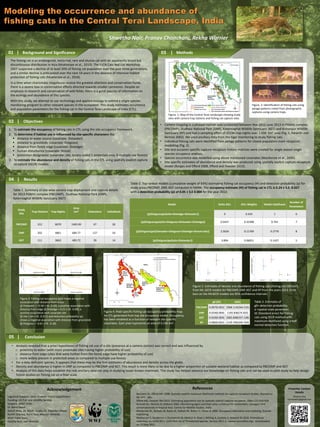
1. Methods03 |
- Shwetha Nair, Pranav Chanchani, Rekha Warrier
Background and Significance01 |
The fishing cat is an endangered, nocturnal, rare and elusive cat with an apparently broad but
discontinuous distribution in Asia (Mukherjee et al., 2010). The IUCN Cats Red List Workshop
2007 suspected a decline of at least 50% of fishing cat population over the past three generations,
and a similar decline is anticipated over the next 18 years in the absence of intensive habitat
protection of fishing cats (Mukherjee et al., 2010).
In a time when charismatic megafauna receive the greatest attention and conservation funds,
there is a severe bias in conservation efforts directed towards smaller carnivores. Despite an
emphasis in research and conservation of wild felids, there is a great paucity of information on
the ecology and abundance of this species.
With this study, we attempt to use technology and applied ecology to extend a single species
monitoring program to other relevant species in the ecosystem. This study estimates occurrence
and population parameters for the fishing cat in the Central Terai Landscape of India (CTL).
Objectives02 |
1. To estimate the occupancy of fishing cats in CTL using the site occupancy framework.
2. To determine if habitat use is influenced by site-specific characters like:
distance to water source (covariate: Distwater)
distance to grasslands (covariate: Distgrass)
distance from forest edge (covariate: Distedge)
human disturbance (covariate: threat)
protection designation (covariate: site, binary coded 1-protected area, 0-multiple use forests)
3. To estimate the abundance and density of fishing cats in the CTL using spatially explicit capture
recapture (SECR) models.
• Camera trapping in a phased manner was conducted between Nov 2012-June 2013 in Pilibhit complex
(PBCOMP), Dudhwa National Park (DNP), Katerniaghat Wildlife Sanctuary (KGT) and Kishanpur Wildlife
Sanctuary (KP) and had a sampling effort of 15194 trap nights over 2,434 km2 area (Fig. 1, Karanth and
Nichols 2002). We used ancillary data from the tiger monitoring to study fishing cats.
• Individual fishing cats were identified from pelage patterns for closed population mark recapture
modelling (Fig. 2).
• Site and occasion specific capture-recapture history matrices were created for single season single
species occupancy analysis.
• Species occurrence was modelled using above mentioned covariates (MacKenzie et al., 2006).
• Site specific estimates of abundance and density was produced using spatially explicit capture-recapture
model (Borges and Efford 2008, Efford and Fewster 2013).
Results04 |
Study
Site
Trap Stations Trap Nights
Area
km2 Detections Individuals
PBCOMP 312 6670 1465.95 47 26
DNP 202 4861 684.77 127 54
KGT 111 3663 483.72 39 14
Table 1. Summary of site-wise camera trap deployment and capture details
for 2013 Pilibhit complex (PBCOMP), Dudhwa National Park (DNP),
Katerniaghat Wildlife Sanctuary (KGT)
Conclusion05 |
• Analysis revealed that a priori hypotheses of fishing cat use of a site (presence at a camera station) was correct and was influenced by
o proximity to water (with more proximate sites having higher probability of use)
o distance from edge (sites that were further from the forest edge have higher probability of use)
o more widely present in protected areas as compared to multiple use forests
• For a data deficient species, it appears that these may be the first estimates of abundance and density across the globe.
• Density and abundance is higher in DNP as compared to PBCOMP and KGT. This result is more likely to be due to a higher proportion of suitable wetland habitat as compared to PBCOMP and KGT.
• Analysis of this data helps establish the role ancillary data can play in studying lesser known mammals. This study has helped advance our knowledge on fishing cats and can be used as pilot study to help design
future studies on fishing cat on a finer scale.
Acknowledgement
Logistical Support: Uttar Pradesh Forest Department
Funding: US Fish and Wildlife Service
Support: WWF India
Dr. Barry Noon
Ashish Bista, Dr. Mudit Gupta, Dr. Dipankar Ghose
Ruchir Sharma, Rohit Ravi, Macson Almeida
WWF Field Team
Kavitha Nair, Joel Almeida
Borchers DL, Efford MG 2008. Spatially explicit maximum likelihood methods for capture-recapture studies. Biometrics
64: 377 - 385.
Efford MG, Fewster RM 2013. Estimating population size by spatially explicit capture–recapture. Oikos 122:918-928
Karanth KU, Nichols JD (editors) 2002. Monitoring tigers and their prey: a manual for researchers, managers and
conservationists in tropical Asia. Centre for Wildlife Studies, India.
Mackenzie DL, Nichols JD, Royle JA, Pollock KE, Bailey LL, Hines JE 2006. Occupancy estimation and modeling. Elsevier
Publishing.
Mukherjee S, Sanderson J, Duckworth W, Melisch R, Khan J, Wilting A, Sunarto S, Howard JG 2010. Prionailurus
viverrinus. In: IUCN 2011. IUCN Red List of Threatened Species. Version 2011.2. <www.iucnredlist.org>. Downloaded
on 12 May 2012
References
Model Delta AICc AICc Weights Model Likelihood
Number of
Parameters
{p(Distgrass)psi(site+Distedge+Distwater)} 0 0.424 1 6
{p(Distgrass)psi(site+Distgrass+Distwater+Distedge)} 0.5437 0.32308 0.762 7
{p(Distgrass)psi(Distwater+Distgrass+Distedge+threat+site)} 2.5634 0.11769 0.2776 8
{p(Distgrass)psi(site+Distwater)} 3.894 0.06051 0.1427 5
Table 2. Top ranked models (cumulative weight of 93%) estimating fishing cat occupancy (Ψ) and detection probability (p) for
study areas PBCOMP, DNP, KGT computed in MARK. The occupancy estimate (Ψ) of fishing cat in CTL is 0.24 ± S.E. 0.027
with a detection probability (p) of 0.05 ± S.E 0.004 for the year 2013.
Figure 3. Fishing cat occupancy (psi) shows a negative
association with distance from water
(β Distwater = -0.58 ± SE. 0.20), a positive association with
distance from edge (β Distedge = 0.21 ± SE. 0.09), a
positive association with covariate site
(β site 1.64 ± SE. 0.321) and detection probability (p)
shows a negative association with distance from grasslands
(β Distgrass = -0.61 ± SE. 0.18).
Figure 4. Pixel-specific fishing cat occupancy probability map
for CTL generated from top site occupancy model. Occupancy
has been modeled as a function of relevant site specific
covariates. Each pixel represents an area of 0.336 km2.
Figure. 1: Map of the Central Terai Landscape showing study
sites with camera trap stations and fishing cat capture sites.
Figure. 2: Identification of fishing cats using
pelage patterns noted from photographic
captures using camera traps.
Presenter Contact
Details
Shwetha Nair
nairshwetha@gmail.com
g0 (SE) σ(SE)
PBCOMP 0.007(0.002) 2068.114(264.210)
DNP 0.024(0.004) 1192.836(74.502)
KGT 0.010(0.004) 2065.848(337.138)
KP 0.006(0.002) 2129.706(340.704)
Figure 5. Estimates of density and abundance of fishing cats (fishing cat/100 km2)
from ML-SECR models for PBCOMP, DNP, KGT and KP from the years 2013. Error
bars on the MLSECR models are 95% confidence intervals.
Table 3. Estimates of
g0= detection probability,
σ =spatial scale parameter,
SE (Standard error) for fishing
cats using SECR method with
maximum-likelihood using a half
normal detection function.