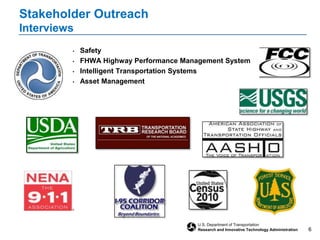
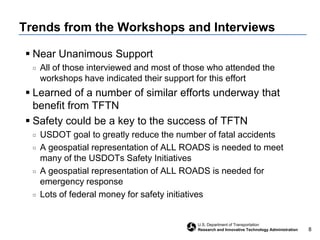
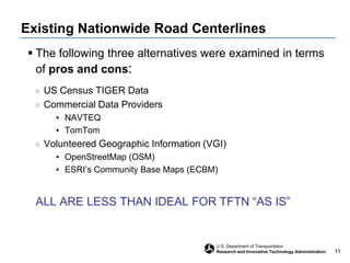
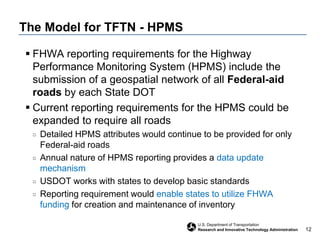
The document discusses strategic planning efforts for the Transportation for the Nation (TFTN) initiative to create a nationwide geospatial dataset of all roads. TFTN would build upon existing efforts and data sources to establish a common baseline of road centerline geometry, attributes, and identifiers. Stakeholder outreach identified support for TFTN and its potential to support safety goals. Moving forward, the plan is to finalize the strategic plan, develop a business plan to identify costs and funding, and begin implementation in 2012 by building on state reporting to the Highway Performance Monitoring System.
July 21, 2021
NCompass Live - http://nlc.nebraska.gov/NCompassLive/
Introduction to U.S. Census Bureau Data Products and Tools, American Community Survey Concepts and Profiles, and new data access platform data.census.gov. The purpose of this informational data session is to acquaint organizations to Census data tools and data.census.gov. By the end of the presentation, participants will be able to access Quick Facts, American Community Survey (ACS) Narrative Profile, and Data Social/Economic Profiles, which provides quick and easy access to select statistics collected by the U.S. Census Bureau.
Presenter: Blanca E. Ramirez-Salazar, Partnership Specialist, Dallas Regional Census Center/Field Division/Denver Region, U.S. Census Bureau.
Twenty Years of Rural Transportation Planning: Revisiting and Renewing North ...RPO America
Tim Brock, North Carolina Department of Transportation, and Matt Day, Triangle J Council of Governments co-presented on North Carolina's rural planning organizations at the 2020 National Regional Transportation Conference.
GraphRAG is All You need? LLM & Knowledge GraphGuy Korland
Guy Korland, CEO and Co-founder of FalkorDB, will review two articles on the integration of language models with knowledge graphs.
1. Unifying Large Language Models and Knowledge Graphs: A Roadmap.
https://arxiv.org/abs/2306.08302
2. Microsoft Research's GraphRAG paper and a review paper on various uses of knowledge graphs:
https://www.microsoft.com/en-us/research/blog/graphrag-unlocking-llm-discovery-on-narrative-private-data/
Transcript: Selling digital books in 2024: Insights from industry leaders - T...BookNet Canada
The publishing industry has been selling digital audiobooks and ebooks for over a decade and has found its groove. What’s changed? What has stayed the same? Where do we go from here? Join a group of leading sales peers from across the industry for a conversation about the lessons learned since the popularization of digital books, best practices, digital book supply chain management, and more.
Link to video recording: https://bnctechforum.ca/sessions/selling-digital-books-in-2024-insights-from-industry-leaders/
Presented by BookNet Canada on May 28, 2024, with support from the Department of Canadian Heritage.
Search and Society: Reimagining Information Access for Radical FuturesBhaskar Mitra
The field of Information retrieval (IR) is currently undergoing a transformative shift, at least partly due to the emerging applications of generative AI to information access. In this talk, we will deliberate on the sociotechnical implications of generative AI for information access. We will argue that there is both a critical necessity and an exciting opportunity for the IR community to re-center our research agendas on societal needs while dismantling the artificial separation between the work on fairness, accountability, transparency, and ethics in IR and the rest of IR research. Instead of adopting a reactionary strategy of trying to mitigate potential social harms from emerging technologies, the community should aim to proactively set the research agenda for the kinds of systems we should build inspired by diverse explicitly stated sociotechnical imaginaries. The sociotechnical imaginaries that underpin the design and development of information access technologies needs to be explicitly articulated, and we need to develop theories of change in context of these diverse perspectives. Our guiding future imaginaries must be informed by other academic fields, such as democratic theory and critical theory, and should be co-developed with social science scholars, legal scholars, civil rights and social justice activists, and artists, among others.
Let's dive deeper into the world of ODC! Ricardo Alves (OutSystems) will join us to tell all about the new Data Fabric. After that, Sezen de Bruijn (OutSystems) will get into the details on how to best design a sturdy architecture within ODC.
Kubernetes & AI - Beauty and the Beast !?! @KCD Istanbul 2024Tobias Schneck
As AI technology is pushing into IT I was wondering myself, as an “infrastructure container kubernetes guy”, how get this fancy AI technology get managed from an infrastructure operational view? Is it possible to apply our lovely cloud native principals as well? What benefit’s both technologies could bring to each other?
Let me take this questions and provide you a short journey through existing deployment models and use cases for AI software. On practical examples, we discuss what cloud/on-premise strategy we may need for applying it to our own infrastructure to get it to work from an enterprise perspective. I want to give an overview about infrastructure requirements and technologies, what could be beneficial or limiting your AI use cases in an enterprise environment. An interactive Demo will give you some insides, what approaches I got already working for real.
Accelerate your Kubernetes clusters with Varnish CachingThijs Feryn
A presentation about the usage and availability of Varnish on Kubernetes. This talk explores the capabilities of Varnish caching and shows how to use the Varnish Helm chart to deploy it to Kubernetes.
This presentation was delivered at K8SUG Singapore. See https://feryn.eu/presentations/accelerate-your-kubernetes-clusters-with-varnish-caching-k8sug-singapore-28-2024 for more details.
Builder.ai Founder Sachin Dev Duggal's Strategic Approach to Create an Innova...Ramesh Iyer
In today's fast-changing business world, Companies that adapt and embrace new ideas often need help to keep up with the competition. However, fostering a culture of innovation takes much work. It takes vision, leadership and willingness to take risks in the right proportion. Sachin Dev Duggal, co-founder of Builder.ai, has perfected the art of this balance, creating a company culture where creativity and growth are nurtured at each stage.
Epistemic Interaction - tuning interfaces to provide information for AI supportAlan Dix
Paper presented at SYNERGY workshop at AVI 2024, Genoa, Italy. 3rd June 2024
https://alandix.com/academic/papers/synergy2024-epistemic/
As machine learning integrates deeper into human-computer interactions, the concept of epistemic interaction emerges, aiming to refine these interactions to enhance system adaptability. This approach encourages minor, intentional adjustments in user behaviour to enrich the data available for system learning. This paper introduces epistemic interaction within the context of human-system communication, illustrating how deliberate interaction design can improve system understanding and adaptation. Through concrete examples, we demonstrate the potential of epistemic interaction to significantly advance human-computer interaction by leveraging intuitive human communication strategies to inform system design and functionality, offering a novel pathway for enriching user-system engagements.
Smart TV Buyer Insights Survey 2024 by 91mobiles.pdf91mobiles
91mobiles recently conducted a Smart TV Buyer Insights Survey in which we asked over 3,000 respondents about the TV they own, aspects they look at on a new TV, and their TV buying preferences.
FIDO Alliance Osaka Seminar: Passkeys and the Road Ahead.pdf
Lewis TFTN FGDC
1. Strategic Planning for Transportation for the Nation (TFTN) Steve Lewis Geospatial Information Officer, USDOT Director, Office of Geospatial Information Systems, USDOT/RITA/BTS April 19, 2011
2. Background Influenced by several different efforts: In 2008, an “issues brief” by NSGIC called for the creation of TFTN OMB Circular A-16 identifies the USDOT as the “lead agency” for the “transportation theme” of the National Spatial Data Infrastructure (NSDI). Emerging USDOT data requirements for geospatial data for all roads, such as accident reporting for enhanced safety and bridge inventory. Aligned with several initiatives such the emerging federal Geospatial Platform concept. - one element of the “geospatial portfolio”
3. TFTN Concept “Creation and maintenance of high-quality, nationwide transportation data that is in the public domain” An initial focus on street centerlines, but eventually multi-modal Nationwide data spanning all states and territories All roads, not just Federally funded roads Provides a common geometric baseline Road naming Persistent segment ID numbering Advanced functionality is built on top of baseline Data is in the public domain and readily shareable
4. Project Governance USDOT/RITA Project Management Advisory input from NSGIC Consulting Team: KTS & AppGeo Steering Committee Executive Members (7) At-Large Members (36) Project Website: http://www.tftn.org/
5. Strategic Planning Effort – What We Did Identify and engage stakeholders Define requirements, challenges and opportunities Document progress already made Existing Datasets Best Practices New Ideas Explore implementation issues Evaluate funding sources
10. Trends from the Workshops and Interviews Near Unanimous Support All of those interviewed and most of those who attended the workshops have indicated their support for this effort Learned of a number of similar efforts underway that benefit from TFTN Safety could be a key to the success of TFTN USDOT goal to greatly reduce the number of fatal accidents A geospatial representation of ALL ROADS is needed to meet many of the USDOTs Safety Initiatives A geospatial representation of ALL ROADS is needed for emergency response Lots of federal money for safety initiatives
11.
12.
13. Existing Nationwide Road Centerlines The following three alternatives were examined in terms of pros and cons: US Census TIGER Data Commercial Data Providers NAVTEQ TomTom Volunteered Geographic Information (VGI) OpenStreetMap (OSM) ESRI’s Community Base Maps (ECBM) ALL ARE LESS THAN IDEAL FOR TFTN “AS IS”
14. The Model for TFTN - HPMS FHWA reporting requirements for the Highway Performance Monitoring System (HPMS) include the submission of a geospatial network of all Federal-aid roads by each State DOT Current reporting requirements for the HPMS could be expanded to require all roads Detailed HPMS attributes would continue to be provided for only Federal-aid roads Annual nature of HPMS reporting provides a data update mechanism USDOT works with states to develop basic standards Reporting requirement would enable states to utilize FHWA funding for creation and maintenance of inventory
15. Obstacles Associated With This Model FHWA has to change the HPMS Reporting Requirements to include all roads in the geospatial submission States are not required to work with neighbors for connectivity No USDOT resources currently available for aggregation, assembly and publication of a nationwide data set The level of quality/accuracy varies from State to State Although there is general agreement that the state DOTs are the authoritative source for street centerlines for their respective jurisdictions, there is very little independent verification of their accuracy
28. Case Studies Outline OH: Example of state activatingcounties NY: Example of state-private sector partnership for centerlines MI: Example of a state GIS office assisting a state DOT KY: Statewide, multi-purpose centerline used for HPMS, E-911, etc. VA Counties: Example of multiple counties collaborating for centerlines WA Pooled Funds Study: Example of a multi-state, regional data collection and integration effort I-95 Corridor Study: Example of multi-state data integration and update challenges
29. Ohio: Collaboration on Street Centerlines The Location Based Response System (LBRS) is a partnership between state and local government to develop: Highly-accurate (+/- 1 m), field-verified street centerlines Address point locations for the entire state The state has developed a set of standards and provides financial incentive to counties through a Memorandum of Agreement (MOA) to provide funds This effort has resulted in the successful culmination of many organizations working together to provide accurate centerline data throughout the state for use by: Emergency response organizations State geospatial programs
30. New York: Multi-purpose Centerline Outlook and Involvement from the State GIS Office In the late 1990s, New York State launched a statewide baseline mapping program utilizing GIS to upgrade how the New York DOT/DMV maintained their road data Conform to the new state standard Focus on Federal regulations from such program as the FHWA Highway Performance Monitoring System (HPMS). With a single street centerline layer, other agencies will be able to consume this data Support multiple applications Support county and local government A web portal where counties can upload/download data was created. The data is verified, incorporated in to the working set and then disseminated back to State and other entities such as NAVTEQ.
31. Michigan: State GIS office Assists the Michigan DOT The Michigan State GIS office is currently undergoing an effort called the Transportation Data Stewardship Enhancement Plan The program utilizes five full time staff members who work constantly to maintain the data Because of the strict nature and use of the State data model, it has been reported that the State’s submission to HPMS has had no errors over the past several years The Michigan State GIS office has assembled a robust and accurate road centerline that covers a majority of the State
32. Kentucky: Linkage of the Transportation Centerline to HPMS, other route-dependent datasets and E-911 In the late 1990’s the Kentucky State Public Centerline project was originally conceived as the brainchild of Greg Witt from the Kentucky Department of Transportation (KDOT), to: Derive better statistical information and analytical products from all of the centerline data for the State Move the State’s geospatial data infrastructure into a geographic information system (GIS) powered by LRS Tremendous effort was put forth for funding to contract with Area Development Districts (ADDs) from around the State for data: Foundation data layer that could be used by other agencies within the state, the Federal Highway Administration (FHWA), and the general public These data also represent data sources that would not otherwise be available statewide without a high level of collaboration between all stakeholders within the State The resulting efforts have made for seamless submission to HPMS and help to enhance its performance and accuracy
33.
34. Develop a routable road centerline data set and standard usable by Computer-Aided Dispatch (CAD) systems.
35. Enhance VGIN Road Centerlines (RCL) for supporting routing, geocoding, and persistent updates to local 911 map systems. It will
36. Support each individual CAD system for data outside their own jurisdiction (while not forcing them to change the data model currently used in CAD)
37. The VGIN RCL project is considered a huge local success because of the communication and handshaking that occurs between the state GIS and the state DOT
38. Will eventually have a seamless flow from participating cities and counties up to the state and then back again to complete the round trip
39.
40. 8 Federal Agencies, 7 States, 14 Washington State agencies, 23 counties, 10 cities, 9 tribal governments, and 20 other private and public entities
41. WA-Trans has been working in cooperation with six other state DOTs to develop computer-based tools that facilitate transportation data sharing and integration financed with federal funds, specifically Transportation Pooled Funds (TPF)
42. Executed at the state level with data collected from a local level, integrated at a state level, and shared to all project participants
43.
44. Consolidates existing state roadway network databases into a single multi-state roadway network to guide regional transportation planning and emergency management efforts
45. The individual state roadway databases are ‘stitched together’ at the state borders to form a topologically integrated network
46. Many variations in data contents and consistency for road datasets were encountered from state-to-state
47. Generally, useful and reasonably accurate road features were available to produce a public domain road network for the Corridor
48. Conclusion: It might be easier to use a stripped down commercial roadway centerline network as a framework
52. We concluded that existing nationwide road centerlines are not adequate for TFTN requirements in their current “as is” condition or form
53. The main recommendation is to build on FHWA’s HPMS program, and take a new approach consistent with USDOT’s responsibility as the lead federal agency for the Transportation Theme of NSDI