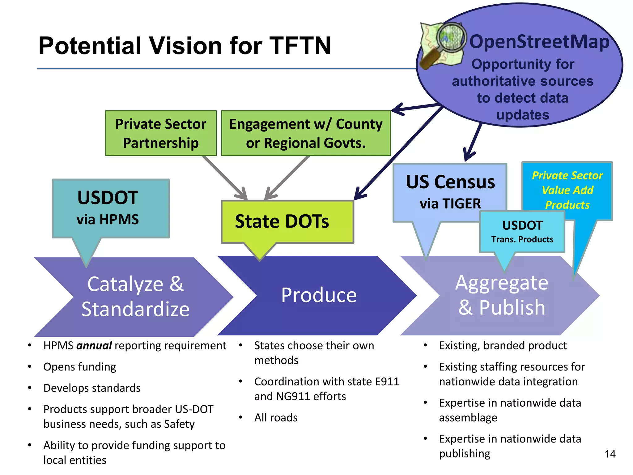
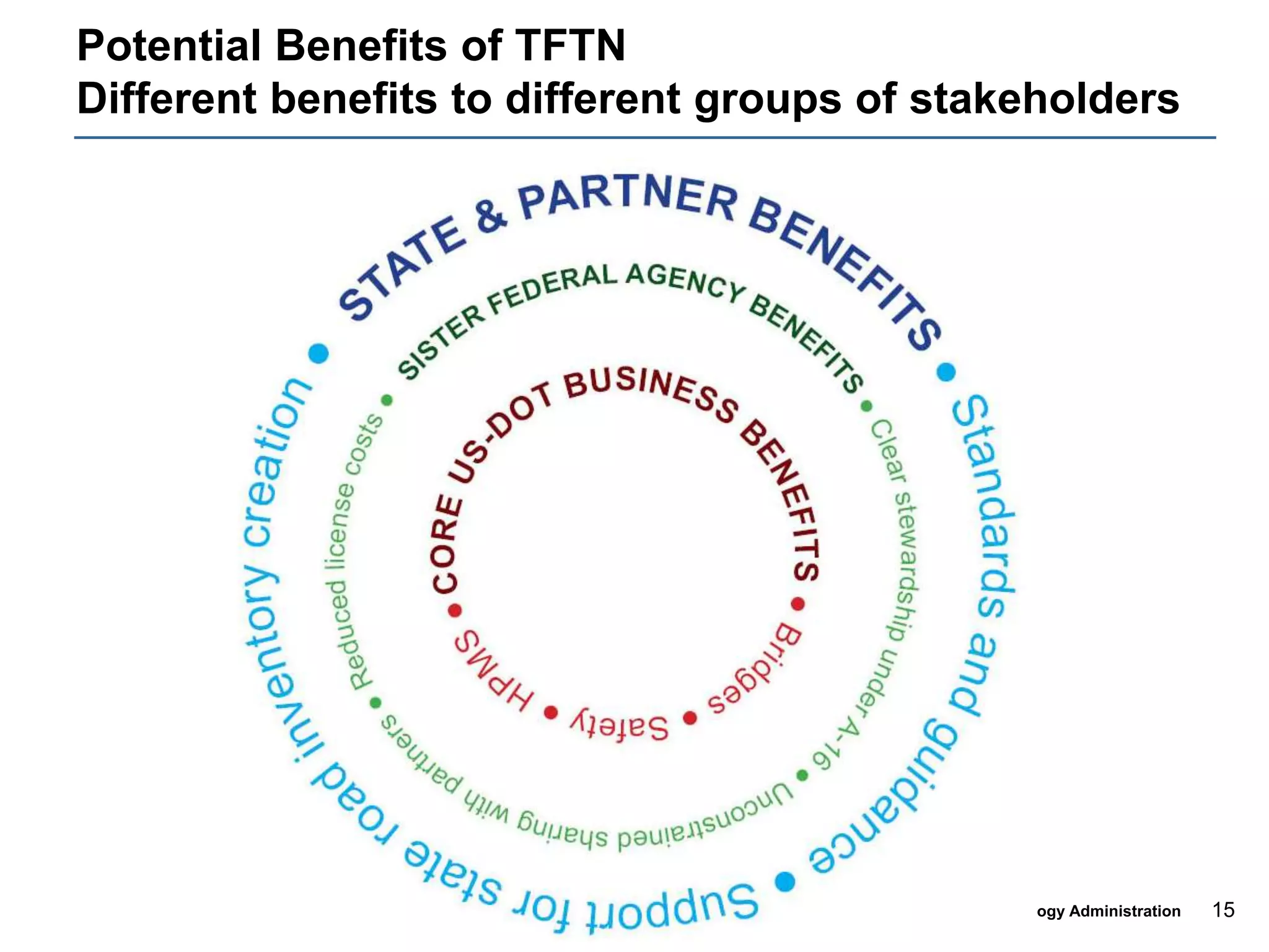
Strategic Planning for
Transportation for the Nation (TFTN)
Steve Lewis
Geospatial Information Officer, USDOT
Director, Office of Geospatial Information Systems, USDOT/RITA/BTS
November 1, 2010
2
U.S. Department of Transportation
Research and Innovative Technology Administration
Background
Influenced by several different efforts:
 In 2008, an “issues brief” by NSGIC called for the creation of TFTN
 OMB Circular A-16 identifies the USDOT as the “lead agency” for
the “transportation theme” of the National Spatial Data Infrastructure
(NSDI).
ď‚§ Emerging USDOT data requirements for geospatial data for all
roads, such as accident reporting for enhanced safety and bridge
inventory.
ď‚§ Aligned with several initiatives such the emerging federal
Geospatial Platform concept. - one element of the “geospatial
portfolio”
3
U.S. Department of Transportation
Research and Innovative Technology Administration
TFTN Concept
“Creation and maintenance of high-quality, nationwide
transportation data that is in the public domain”
â–ˇ An initial focus on street centerlines, but eventually multi-modal
â–ˇ Nationwide data spanning all states and territories
â–ˇ All roads, not just Federally funded roads
â–ˇ Provides a common geometric baseline
â–Ş Road naming
â–Ş Persistent segment ID numbering
â–Ş Advanced functionality is built on top of baseline
â–ˇ Data is in the public domain and readily shareable
4
U.S. Department of Transportation
Research and Innovative Technology Administration
Strategic Planning Effort - History
ď‚§RITA/BTS agreed to fund and manage the effort
ď‚§Funds obligated and contractor selected in October 2009
â–ˇ Koniag Technology Solutions
â–ˇ Applied Geographics
ď‚§Suffered through many contracting glitches associated
with “end-of-year” money
ď‚§Contract finally awarded in March 2010
5
U.S. Department of Transportation
Research and Innovative Technology Administration
Strategic Planning Effort – The Process
ď‚§Identify and engage stakeholders
ď‚§Define requirements, challenges and opportunities
ď‚§Document progress already made
â–ˇ Existing Datasets
â–ˇ Best Practices
â–ˇ New Ideas
ď‚§Explore implementation issues
ď‚§Evaluate funding sources
6
U.S. Department of Transportation
Research and Innovative Technology Administration
Stakeholder Outreach - Presentations &
Workshops
7
U.S. Department of Transportation
Research and Innovative Technology Administration
Stakeholder Outreach - Interviews
• Safety
• Highway Performance Management System
• Intelligent Transportation Systems
• Asset Management
• Deputy Director of RITA
8
U.S. Department of Transportation
Research and Innovative Technology Administration
Trends from the Workshops and Interviews
ď‚§ Near Unanimous Support
â–ˇ All of those interviewed and most of those who attended the
workshops have indicated their support for this effort
ď‚§ Learned of a number of similar efforts underway that
benefit from TFTN
ď‚§ Safety could be a key to the success of TFTN
â–ˇ A geospatial representation of ALL ROADS is needed to meet
many of the USDOTs Safety Initiatives
â–ˇ A geospatial representation of ALL ROADS is needed for
emergency response
â–ˇ Lots of federal money for safety initiatives
9
U.S. Department of Transportation
Research and Innovative Technology Administration
Trends from the Workshops and Interviews
 “Think Regionally Act Locally”
â–ˇ States and counties are beginning to look beyond their borders
â–ˇ States and counties are the authoritative data source for their
transportation data
 “Can you live with that?”
â–ˇ The Stakeholders have different needs
â–ˇ Need to find a baseline that works with everyone
â–ˇ Once the baseline is established, the consumers can add their
own “special sauce”
10
U.S. Department of Transportation
Research and Innovative Technology Administration
Baseline Geometry with “Special Sauce”
 The specifics of what’s included in “baseline geometry”
requires further definition
ď‚§ Initial, minimal components might be:
â–ˇ Road naming
â–ˇ Basic attributes (e.g. functional classification)
â–ˇ Persistent segment ID numbering
ď‚§ Seeking additional ideas and input from stakeholders on
what’s feasible
 “Special sauce” can be content and/or capabilities
11
U.S. Department of Transportation
Research and Innovative Technology Administration
Variety of stakeholders adds their own “special
sauce” on top
•TFTN: Common baseline foundation
of geometry, basic attributes
•State DOTs: Linear Referencing System (LRS)
•State DOTs: advanced attributes
•Private Sector: full routability and
immersive imagery
•USGS: Enhanced cartographic display and
labeling
•US Census: Polygon topology for census
geographic units
•State E911: Addresses
12
U.S. Department of Transportation
Research and Innovative Technology Administration
A Potential Model for TFTN - HPMS
ď‚§ FHWA reporting requirements for the Highway
Performance Monitoring System (HPMS) include the
submission of a geospatial network of all Federal-aid
roads by each State DOT
ď‚§ Current reporting requirements for the HPMS could be
expanded to require all roads
â–ˇ Detailed HPMS attributes would continue to be provided for only
Federal-aid roads
â–ˇ Annual nature of HPMS reporting provides a data update
mechanism
â–ˇ USDOT works with states to develop basic standards
â–ˇ Reporting requirement would enable states to utilize FHWA
funding for creation and maintenance of inventory
13
U.S. Department of Transportation
Research and Innovative Technology Administration
Obstacles Associated With This Model
ď‚§ FHWA has to change the HPMS Reporting
Requirements to include all roads in the geospatial
submission
ď‚§ States are not required to work with neighbors for
connectivity
ď‚§ No USDOT resources currently available for
aggregation, assembly and publication of a nationwide
data set
ď‚§ The level of quality/accuracy varies from State to State
14
U.S. Department of Transportation
Research and Innovative Technology Administration
Potential Vision for TFTN
ProduceCatalyze &
Standardize
Aggregate
& Publish
USDOT
via HPMS
• HPMS annual reporting requirement
• Opens funding
• Develops standards
• Products support broader US-DOT
business needs, such as Safety
• Ability to provide funding support to
local entities
US Census
via TIGER
• Existing, branded product
• Existing staffing resources for
nationwide data integration
• Expertise in nationwide data
assemblage
• Expertise in nationwide data
publishing
OpenStreetMap
Opportunity for
authoritative sources
to detect data
updates
Private Sector
Value Add
Products
State DOTs
Private Sector
Partnership
Engagement w/ County
or Regional Govts.
• States choose their own
methods
• Coordination with state E911
and NG911 efforts
• All roads
USDOT
Trans. Products
15
U.S. Department of Transportation
Research and Innovative Technology Administration
Potential Benefits of TFTN
Different benefits to different groups of stakeholders
16
U.S. Department of Transportation
Research and Innovative Technology Administration
Examples of what have we heard so
far…
17
U.S. Department of Transportation
Research and Innovative Technology Administration
At the ESRI User Conference
ď‚§ Short-term and long-term considerations
□ Short term: don’t forget several nationwide datasets currently exist
â–Ş TIGER
â–Ş Commercial
â–Ş OpenStreetMap
â–ˇ Longer term: design and build something new
ď‚§ HPMS is not resourced to make a seamless nationwide data
set
□ Look at other “process models” too!
â–ˇ Public/private partnership
â–ˇ Build on TIGER
â–ˇ Volunteered Geographic Information (VGI)
□ Something “outside-the-box” that we have yet to imagine
18
U.S. Department of Transportation
Research and Innovative Technology Administration
Census Bureau Interview Takeaways
ď‚§ TIGER is a mature product
â–ˇ Many users depend on it for a variety of applications
â–Ş National broadband mapping (for Census geometry)
ď‚§ Significant improvements in latest TIGER files
â–ˇ Positional accuracy improved (7.6 meter)
â–ˇ Substantial input from local sources incorporated
â–ˇ Research into potential for OpenStreetMap
ď‚§ Planning for more frequent updates (depending on funding)
19
U.S. Department of Transportation
Research and Innovative Technology Administration
USGS Interview Takeaways
ď‚§ Requirement for nationwide roads in The National Map
(TNM)
ď‚§ TIGER did not meet TNM requirements
â–ˇ Positional accuracy
â–ˇ Depictions of interchanges and dual-carriageways
â–ˇ Attributes
â–ˇ Costs to retrofit TIGER were prohibitive
ď‚§ Have currently replaced TIGER with TeleAtlas data
â–ˇ Competitive price, but restricted use
â–ˇ Looking at OpenStreetMap and other alternatives, long-term
ď‚§ The National Hydrography Dataset (NHD) provides a
positive example of Federal-State collaboration
20
U.S. Department of Transportation
Research and Innovative Technology Administration
At the NSGIC Annual Conference
ď‚§ Develop a matrix of common requirements and approaches
– “what are the shared needs and commonalities?”
ď‚§ Develop an inventory of what each state has for statewide
street centerlines
ď‚§ Develop several success stories as 1-2 page fact sheets,
perhaps as “tiered” levels of success
 The Census Bureau considers itself to be a “Data
Integrator,” not a Data Producer per se; boundaries are the
“real issue” for Census Bureau, not roads; DOTs might
need greater detail
ď‚§ Next Generation 911 is and will be a big driver for GIS-
based initiatives to build statewide street centerline data
sets to support automated routing
21
U.S. Department of Transportation
Research and Innovative Technology Administration
GIS Pro Takeaways
ď‚§ Data Sharing is two way relationship
□ “Co-dependency” can lead to success
ď‚§ Increased involvement in planning process from local government
stakeholders is desirable
 Public/Private Partnership: “knotty issues” of licensing will need to
be addressed.
□ 2004 study from National Academy of Science titled “Licensing of
Geographic Data and Services” could be a resource.
ď‚§ Needs to be an emphasis on identifying what is in the core,
common base of TFTN (vs. special sauce).
□ US Census pointed to “Federal Survey” of 19 agencies that identified their
common needs as a starting place.
ď‚§ Baseline data elements should not be complex; added complexity
can affect the success of the project
22
U.S. Department of Transportation
Research and Innovative Technology Administration
The Road Ahead
ď‚§ More interviews, meetings, surveys, case studies, etc.
ď‚§ Through these, we will:
□ Identify what’s working, what’s needed – current practices,
requirements, strategies, standards, documentation
â–ˇ Identify institutional constraints, capacity, operational authority,
motivation, benefits, etc.
â–ˇ Formulate strategies for implementation
â–ˇ Identify potential sources of funding
23
U.S. Department of Transportation
Research and Innovative Technology Administration
Questions?
Steve Lewis
(202) 366-9223
steve.lewis@dot.gov
http://www.tftn.org
http://www.transportationresearch.gov/TFTN/default.aspx

HIFLD Presentation

  • 1.
    Strategic Planning for Transportationfor the Nation (TFTN) Steve Lewis Geospatial Information Officer, USDOT Director, Office of Geospatial Information Systems, USDOT/RITA/BTS November 1, 2010
  • 2.
    2 U.S. Department ofTransportation Research and Innovative Technology Administration Background Influenced by several different efforts:  In 2008, an “issues brief” by NSGIC called for the creation of TFTN  OMB Circular A-16 identifies the USDOT as the “lead agency” for the “transportation theme” of the National Spatial Data Infrastructure (NSDI).  Emerging USDOT data requirements for geospatial data for all roads, such as accident reporting for enhanced safety and bridge inventory.  Aligned with several initiatives such the emerging federal Geospatial Platform concept. - one element of the “geospatial portfolio”
  • 3.
    3 U.S. Department ofTransportation Research and Innovative Technology Administration TFTN Concept “Creation and maintenance of high-quality, nationwide transportation data that is in the public domain” □ An initial focus on street centerlines, but eventually multi-modal □ Nationwide data spanning all states and territories □ All roads, not just Federally funded roads □ Provides a common geometric baseline ▪ Road naming ▪ Persistent segment ID numbering ▪ Advanced functionality is built on top of baseline □ Data is in the public domain and readily shareable
  • 4.
    4 U.S. Department ofTransportation Research and Innovative Technology Administration Strategic Planning Effort - History RITA/BTS agreed to fund and manage the effort Funds obligated and contractor selected in October 2009 □ Koniag Technology Solutions □ Applied Geographics Suffered through many contracting glitches associated with “end-of-year” money Contract finally awarded in March 2010
  • 5.
    5 U.S. Department ofTransportation Research and Innovative Technology Administration Strategic Planning Effort – The Process Identify and engage stakeholders Define requirements, challenges and opportunities Document progress already made □ Existing Datasets □ Best Practices □ New Ideas Explore implementation issues Evaluate funding sources
  • 6.
    6 U.S. Department ofTransportation Research and Innovative Technology Administration Stakeholder Outreach - Presentations & Workshops
  • 7.
    7 U.S. Department ofTransportation Research and Innovative Technology Administration Stakeholder Outreach - Interviews • Safety • Highway Performance Management System • Intelligent Transportation Systems • Asset Management • Deputy Director of RITA
  • 8.
    8 U.S. Department ofTransportation Research and Innovative Technology Administration Trends from the Workshops and Interviews ď‚§ Near Unanimous Support â–ˇ All of those interviewed and most of those who attended the workshops have indicated their support for this effort ď‚§ Learned of a number of similar efforts underway that benefit from TFTN ď‚§ Safety could be a key to the success of TFTN â–ˇ A geospatial representation of ALL ROADS is needed to meet many of the USDOTs Safety Initiatives â–ˇ A geospatial representation of ALL ROADS is needed for emergency response â–ˇ Lots of federal money for safety initiatives
  • 9.
    9 U.S. Department ofTransportation Research and Innovative Technology Administration Trends from the Workshops and Interviews  “Think Regionally Act Locally” □ States and counties are beginning to look beyond their borders □ States and counties are the authoritative data source for their transportation data  “Can you live with that?” □ The Stakeholders have different needs □ Need to find a baseline that works with everyone □ Once the baseline is established, the consumers can add their own “special sauce”
  • 10.
    10 U.S. Department ofTransportation Research and Innovative Technology Administration Baseline Geometry with “Special Sauce”  The specifics of what’s included in “baseline geometry” requires further definition  Initial, minimal components might be: □ Road naming □ Basic attributes (e.g. functional classification) □ Persistent segment ID numbering  Seeking additional ideas and input from stakeholders on what’s feasible  “Special sauce” can be content and/or capabilities
  • 11.
    11 U.S. Department ofTransportation Research and Innovative Technology Administration Variety of stakeholders adds their own “special sauce” on top •TFTN: Common baseline foundation of geometry, basic attributes •State DOTs: Linear Referencing System (LRS) •State DOTs: advanced attributes •Private Sector: full routability and immersive imagery •USGS: Enhanced cartographic display and labeling •US Census: Polygon topology for census geographic units •State E911: Addresses
  • 12.
    12 U.S. Department ofTransportation Research and Innovative Technology Administration A Potential Model for TFTN - HPMS ď‚§ FHWA reporting requirements for the Highway Performance Monitoring System (HPMS) include the submission of a geospatial network of all Federal-aid roads by each State DOT ď‚§ Current reporting requirements for the HPMS could be expanded to require all roads â–ˇ Detailed HPMS attributes would continue to be provided for only Federal-aid roads â–ˇ Annual nature of HPMS reporting provides a data update mechanism â–ˇ USDOT works with states to develop basic standards â–ˇ Reporting requirement would enable states to utilize FHWA funding for creation and maintenance of inventory
  • 13.
    13 U.S. Department ofTransportation Research and Innovative Technology Administration Obstacles Associated With This Model ď‚§ FHWA has to change the HPMS Reporting Requirements to include all roads in the geospatial submission ď‚§ States are not required to work with neighbors for connectivity ď‚§ No USDOT resources currently available for aggregation, assembly and publication of a nationwide data set ď‚§ The level of quality/accuracy varies from State to State
  • 14.
    14 U.S. Department ofTransportation Research and Innovative Technology Administration Potential Vision for TFTN ProduceCatalyze & Standardize Aggregate & Publish USDOT via HPMS • HPMS annual reporting requirement • Opens funding • Develops standards • Products support broader US-DOT business needs, such as Safety • Ability to provide funding support to local entities US Census via TIGER • Existing, branded product • Existing staffing resources for nationwide data integration • Expertise in nationwide data assemblage • Expertise in nationwide data publishing OpenStreetMap Opportunity for authoritative sources to detect data updates Private Sector Value Add Products State DOTs Private Sector Partnership Engagement w/ County or Regional Govts. • States choose their own methods • Coordination with state E911 and NG911 efforts • All roads USDOT Trans. Products
  • 15.
    15 U.S. Department ofTransportation Research and Innovative Technology Administration Potential Benefits of TFTN Different benefits to different groups of stakeholders
  • 16.
    16 U.S. Department ofTransportation Research and Innovative Technology Administration Examples of what have we heard so far…
  • 17.
    17 U.S. Department ofTransportation Research and Innovative Technology Administration At the ESRI User Conference  Short-term and long-term considerations □ Short term: don’t forget several nationwide datasets currently exist ▪ TIGER ▪ Commercial ▪ OpenStreetMap □ Longer term: design and build something new  HPMS is not resourced to make a seamless nationwide data set □ Look at other “process models” too! □ Public/private partnership □ Build on TIGER □ Volunteered Geographic Information (VGI) □ Something “outside-the-box” that we have yet to imagine
  • 18.
    18 U.S. Department ofTransportation Research and Innovative Technology Administration Census Bureau Interview Takeaways ď‚§ TIGER is a mature product â–ˇ Many users depend on it for a variety of applications â–Ş National broadband mapping (for Census geometry) ď‚§ Significant improvements in latest TIGER files â–ˇ Positional accuracy improved (7.6 meter) â–ˇ Substantial input from local sources incorporated â–ˇ Research into potential for OpenStreetMap ď‚§ Planning for more frequent updates (depending on funding)
  • 19.
    19 U.S. Department ofTransportation Research and Innovative Technology Administration USGS Interview Takeaways ď‚§ Requirement for nationwide roads in The National Map (TNM) ď‚§ TIGER did not meet TNM requirements â–ˇ Positional accuracy â–ˇ Depictions of interchanges and dual-carriageways â–ˇ Attributes â–ˇ Costs to retrofit TIGER were prohibitive ď‚§ Have currently replaced TIGER with TeleAtlas data â–ˇ Competitive price, but restricted use â–ˇ Looking at OpenStreetMap and other alternatives, long-term ď‚§ The National Hydrography Dataset (NHD) provides a positive example of Federal-State collaboration
  • 20.
    20 U.S. Department ofTransportation Research and Innovative Technology Administration At the NSGIC Annual Conference  Develop a matrix of common requirements and approaches – “what are the shared needs and commonalities?”  Develop an inventory of what each state has for statewide street centerlines  Develop several success stories as 1-2 page fact sheets, perhaps as “tiered” levels of success  The Census Bureau considers itself to be a “Data Integrator,” not a Data Producer per se; boundaries are the “real issue” for Census Bureau, not roads; DOTs might need greater detail  Next Generation 911 is and will be a big driver for GIS- based initiatives to build statewide street centerline data sets to support automated routing
  • 21.
    21 U.S. Department ofTransportation Research and Innovative Technology Administration GIS Pro Takeaways  Data Sharing is two way relationship □ “Co-dependency” can lead to success  Increased involvement in planning process from local government stakeholders is desirable  Public/Private Partnership: “knotty issues” of licensing will need to be addressed. □ 2004 study from National Academy of Science titled “Licensing of Geographic Data and Services” could be a resource.  Needs to be an emphasis on identifying what is in the core, common base of TFTN (vs. special sauce). □ US Census pointed to “Federal Survey” of 19 agencies that identified their common needs as a starting place.  Baseline data elements should not be complex; added complexity can affect the success of the project
  • 22.
    22 U.S. Department ofTransportation Research and Innovative Technology Administration The Road Ahead  More interviews, meetings, surveys, case studies, etc.  Through these, we will: □ Identify what’s working, what’s needed – current practices, requirements, strategies, standards, documentation □ Identify institutional constraints, capacity, operational authority, motivation, benefits, etc. □ Formulate strategies for implementation □ Identify potential sources of funding
  • 23.
    23 U.S. Department ofTransportation Research and Innovative Technology Administration Questions? Steve Lewis (202) 366-9223 steve.lewis@dot.gov http://www.tftn.org http://www.transportationresearch.gov/TFTN/default.aspx

Editor's Notes

  • #6 Identify and engage stakeholders -All levels of government -Private Sector -Citizens (e.g. OpenStreetMap community)