SlideShare a Scribd company logo
1 of 1
A GPS/GIS Evaluation of Human Encroachment of Nesting Sites and the Habitat of Olive Ridley Sea Turtles
                                                                                 (Lepidochelysolivacea) on the Urbanizing Beaches of Nuevo Vallarta, Nayarit, Mexico
                                                                                                                                                     Julia Carrillo
                                                                                                                                Capstone Advisors : Dr. Yong Lao & Dr. Manuel Carlos
                                                                                                                                                     Spring 2012


Introduction                                                                                                                                                                               Methods
The beaches of Nuevo Vallarta, Nayarit, which include Flamingos, Bucerias and Mayan Palace beaches, are                                                                                    Nest Data
located on Mexico's Pacific coast. These beaches have nesting populations of Olive Ridley sea turtles that                                                                                 A table was provided by NVSTP and its sponsors. Information collected on this table is sent to overseeing government
exceed all others in the state, the Central Coast and the Northwest of Mexico (M. Carlos pers. com). Nuevo                                                                                 agencies. Each nest included data such as date, time, relative location, moon phase, observed tide phase, egg count, and
Vallarta has fourteen kilometers, about eight and a half miles of beachfront property, seven miles of                                                                                      vertical zone of deposition. The 14km beach was divided into 0.5km sections. The distribution of nests and egg count
shippable water channels, and a 300 slip marina. It is located 20 minutes north of Puerto Vallarta in the                                                                                  along the beach were evaluated using descriptive statistics.
adjacent state of Jalisco. The area has been designated for tourist resort development and recently was made
part of the Riviera Nayarit. It is also the site of a sea turtle conservation effort that is being carried out by                                                                          Ethnography
the Comisión Nacional de Áreas Naturales Protegidas (CONANP) and the Mexican non-governmental                                                                                              In order to evaluate nesting data outliers I needed to visit the site. Through participant observation I was able to
organization, AMA MEXICO A.C. through the Nuevo Vallarta Sea Turtle Preserve (NVSTP). Rapid resort                                                                                         understand some of the challenges facing conservation efforts. Additionally, use of this technique provided evidence
development and urbanization of beaches leads to disturbance and habitat fragmentation which reduces                                                                                       unavailable through quantitative methods.
biodiversity and leads populations to extinctions (Davenport & Davenport, 2005) Although, sea turtles face
many challenges for survival, both researchers and conservationists agree that the largest anthropogenic                                                                                   GPS
threat to sea turtles is coastal development. (Donlan, Wingfield, Crowder, & Wilcox, 2008) The purpose of                                                                                  GPS was chosen as the method to measure human intrusion on nesting habitat. A Trimble GeoXM GPS device was
this study is to measure and document human intrusion on sea turtle nesting habitat on a recently urbanized                                                                                used to measure human development on beach shores. This included all beach front structures such as recreational
and commercialized beach. This study also describes nesting preferences along the beach.                                                                                                   sporting courts, palapas (shaded structures made from palm trees ), and areas used to store aquatic recreational vehicles.
                                                                                                                                                                                           Most of the 14km of protected beach was measured, small pockets were not mapped due to fast currents emptying from
                                                                                                                                                                                           rivers due to mass rains. GPS was also used to map areas of human drainage and photographs were used to document
Research Questions                                                                                                                                                                         current pollution to monitor changes. In order to asses compliance of federal laws on coastal habitat high tide needed to
                                                                                                                                                                                           be measured with GPS. To measure loss of protected habitat, available beachfront area needed to be quantified.
(1) Can we characterize the nesting distribution along the North Shore of the Bay of Banderas?
(2) Can we quantify and document human drainage to the sea?
(3) How much protected habitat have humans removed from available nesting use?
                                                                                                                                      Analysis
                                                                                                                                      All GPS data collected was exported from the device using Trimble GPS Pathfinder Office 9.2. The data was
                                                                                                                                      differentially corrected using a base station 70km away in Colima, Mexico. After export, data was imported into
                                                                                                                                      ArcMap 10.0. To quantify human intrusion, a 20 meter buffer of high tide was used as the total available area.
                                                                                                                                      Measured urbanization within the buffer was removed from available nesting grounds. Data collected on drainage
                                                                                                                                      was displayed and had photographs linked to each point.


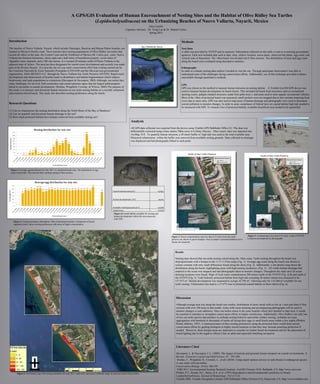
 Figure 1.Average egg distribution for July 2011 vs. protected beach zone. The distribution of egg
 count varied little. This showed little variation among 0.5km sections.


                                                                                                                  Total Protected area (m²)                         157973


                                                                                                                  Human development  (m²)                               43705


                                                                                                                  Available nesting grounds (m²)                    114268
                                                                                                                   Habitat loss                                     27.67%
                                                                                                                   Figure 6.Coastal habitat available for nesting and
                                                                                                                   human development within this area measured
                                                                                                                   with GPS.
    Figure 2. Nesting incidences throughout 14km of protected beaches. Comparison of beach
    segments clearly shows nesting preferences with areas of higher concentration.


                                                                                                                                                                                Figure 4. Beach contamination sites less than 0.25 miles from the turtle             Figure 5. Contamination less than 0.25 miles south of NVSTP.
                                                                                                                                                                                preserve are shown in green triangles. Area in purple is protected habitat lost to   Locations accompanied by photographs.
                                                                                                                                                                                human development.


                                                                                                                                                                                    Results

                                                                                                                                                                                    Nesting data showed that sea turtle nesting varied along the 14km coast. Turtle nesting throughout the beach was
                                                                                                                                                                                    disproportionate with a hotspot at the 11.5-11.9 km range (Fig. 1). Average egg count along the beach was shown to
                                                                                                                                                                                    remain constant with only small differences found along the shore (Fig. 2). Additionally, a dot density map shows the
                                                                                                                                                                                    distribution along the beach, highlighting areas with high nesting incidences. (Fig. 3). All visible human drainage that
                                                                                                                                                                                    emptied to the ocean was mapped and had photographs taken to monitor changes. Throughout the study area 26 ocean
                                                                                                                                                                                    draining locations were found. Maps of local water contamination 200 meters north of the NVSTP (Fig. 4) & and south of
                                                                                                                                                                                    the NVSTP (Fig. 5). Total federally protected habitat from high tide extending 20 meters inland was measured to be
                                                                                                                                                                                    157,973 m². Human development was measured to occupy 43,705 m². Allowing only for 114,268 m² available for sea
                                                                                                                                                                                    turtle nesting. Urbanization has lead to a 27.67% loss in protected coastal habitat on these shores (Fig. 6).


                                                                                                                                                                                     Discussion

                                                                                                                                                                                     Although average nest size along the beach was similar, distribution of nests varied with as few as 1 nest and other 0.5km
                                                                                                                                                                                     sections with over 100 nests in that month. Areas with ocean draining and accompanying photographs will be used to
                                                                                                                                                                                     monitor changes or note additions. Since sea turtles return to the same beaches where they hatched to later nest, it would
                                                                                                                                                                                     be essential to maintain or strengthen conservation efforts in highly nested areas. Additionally, Olive Ridley's are only one
                                                                                                                                                                                     of two sea turtle species that partakes in arribada nesting behavior and unlike solitary nesting, arribadas are mass
                                                                                                                                                                                     aggregations with hundreds to thousands of turtles all laying their eggs in small beach areas within a few nights (Plotkin,
                                                                                                                                                                                     Rostal, &Byles, 1997). A characterization of their nesting preferences along the protected shore would help current
                                                                                                                                                                                     conservation efforts by guiding biologists to highly nested locations so that they may increase poaching protection if
                                                                                                                                                                                     needed. Moreover, these hotspot areas are important to consider for further beach development and for the placement of
                                                                                                                                                                                     beach lighting due to the negative effects it has on adult and especially hatchling navigation.


                                                                                                                                                                                     Literature Cited


                     ±
                                                                                                                                                                                     Davenport, J., & Davenport, J. L. (2005). The impact of tourism and personal leisure transport on coastal environments: A
                                                                                                                                                                                     Review. Estuarine Coastal and Shelf Science. 67 : 292-280.
                                                                                                                                                                                     Donlan, C., Wingfield, D., Crowder, L., et all. (2010). Using expert opinion surveys to rank threats to endangered species:
                                                                                                                                                                                     A case study with sea turtles.
                                                                                                                                                                                     Conservation Biology. 24 (6): 186-195.
                                                             0   0.5   1    2       3      4
                                                                                            Kilometers
                                                                                                                                                                                     ESRI 2011. Environmental Systems Research Institute. ArcGIS (Version 10.0). Redlands, CA. http://www.esri.com.
       Figure 3. Dot density map with nesting incidences for July 2011, each color represents a different range in count per each 0.5km section.                                     Plotkin, P.T., Rostal, D.C., Byles, R.A. et al. (1997) Reproductive and developmental synchrony in female
                                                                                                                                                                                     Lepidochelysolivacea. Journal of Herpetology. 31(1):17-22.
                                                                                                                                                                                     Trimble 2002. Trimble Navigation Limited. GPS Pathfinder Office (Version 9.2). Sunnyvale, CA. http://www.trimble.com.

More Related Content

What's hot

The Challenges for the Palawan Biosphere Reserve in Dealing with Climate Change
The Challenges for the Palawan Biosphere Reserve in Dealing with Climate ChangeThe Challenges for the Palawan Biosphere Reserve in Dealing with Climate Change
The Challenges for the Palawan Biosphere Reserve in Dealing with Climate ChangeNo to mining in Palawan
 
San Diego Bay Integrated Natural Resources Management Plan
San Diego Bay Integrated Natural Resources Management PlanSan Diego Bay Integrated Natural Resources Management Plan
San Diego Bay Integrated Natural Resources Management PlanPort of San Diego
 
Participatory mapping in the design process of a SDI. A case study in the Bio...
Participatory mapping in the design process of a SDI. A case study in the Bio...Participatory mapping in the design process of a SDI. A case study in the Bio...
Participatory mapping in the design process of a SDI. A case study in the Bio...Snowflake Software Ltd
 
Sage may 18 2017 bennett webinarfinal
Sage may 18 2017 bennett webinarfinalSage may 18 2017 bennett webinarfinal
Sage may 18 2017 bennett webinarfinalRick Bennett
 
Gi4DM2010 GIS and geomatics for disaster relief
Gi4DM2010 GIS and geomatics for disaster reliefGi4DM2010 GIS and geomatics for disaster relief
Gi4DM2010 GIS and geomatics for disaster reliefMassimo Lanfranco
 
Palawan Corridor Conservation Strategy and Current Initiatives
Palawan Corridor Conservation Strategy and Current InitiativesPalawan Corridor Conservation Strategy and Current Initiatives
Palawan Corridor Conservation Strategy and Current InitiativesNo to mining in Palawan
 
Poster submission #354 viability study of a costumized gis for the berlenga...
Poster submission #354   viability study of a costumized gis for the berlenga...Poster submission #354   viability study of a costumized gis for the berlenga...
Poster submission #354 viability study of a costumized gis for the berlenga...Ædel Aerospace GmbH
 
A Rapid marine biodiversity assessment of the coral reefs in morales Beach, B...
A Rapid marine biodiversity assessment of the coral reefs in morales Beach, B...A Rapid marine biodiversity assessment of the coral reefs in morales Beach, B...
A Rapid marine biodiversity assessment of the coral reefs in morales Beach, B...Innspub Net
 
Resources Analysis - Province of Palawan, Impacts of Macroeconomic Adjustment...
Resources Analysis - Province of Palawan, Impacts of Macroeconomic Adjustment...Resources Analysis - Province of Palawan, Impacts of Macroeconomic Adjustment...
Resources Analysis - Province of Palawan, Impacts of Macroeconomic Adjustment...No to mining in Palawan
 
Climate change in_a_living_landscape
Climate change in_a_living_landscapeClimate change in_a_living_landscape
Climate change in_a_living_landscapeESTHHUB
 
Tyre ar slides_n_f
Tyre ar slides_n_fTyre ar slides_n_f
Tyre ar slides_n_fZiad Samaha
 
Palawan: A Tinderbox-An Assessment of Environment and Natural Resource Use (E...
Palawan: A Tinderbox-An Assessment of Environment and Natural Resource Use (E...Palawan: A Tinderbox-An Assessment of Environment and Natural Resource Use (E...
Palawan: A Tinderbox-An Assessment of Environment and Natural Resource Use (E...No to mining in Palawan
 
Occurrence patterns of alien freshwater turtles in a large urban pond 'Archip...
Occurrence patterns of alien freshwater turtles in a large urban pond 'Archip...Occurrence patterns of alien freshwater turtles in a large urban pond 'Archip...
Occurrence patterns of alien freshwater turtles in a large urban pond 'Archip...Maria Paola Di Santo
 
Interdisciplinarity in action - Linking science and policy to preserve biodiv...
Interdisciplinarity in action - Linking science and policy to preserve biodiv...Interdisciplinarity in action - Linking science and policy to preserve biodiv...
Interdisciplinarity in action - Linking science and policy to preserve biodiv...luissantamariagaldon
 
Nmoc news may 21
Nmoc news may 21Nmoc news may 21
Nmoc news may 21dyannafrye
 
species composition of intertidal marine macroalgae in san francisco canaoay,...
species composition of intertidal marine macroalgae in san francisco canaoay,...species composition of intertidal marine macroalgae in san francisco canaoay,...
species composition of intertidal marine macroalgae in san francisco canaoay,...INFOGAIN PUBLICATION
 
Discussion of Bulleri et al. 2011 on coastal infrastructure
Discussion of Bulleri et al. 2011 on coastal infrastructure Discussion of Bulleri et al. 2011 on coastal infrastructure
Discussion of Bulleri et al. 2011 on coastal infrastructure Loretta Roberson
 
Pontillas, J. Role of UNESCO's Man and Biosphere Reserves in Climate Change A...
Pontillas, J. Role of UNESCO's Man and Biosphere Reserves in Climate Change A...Pontillas, J. Role of UNESCO's Man and Biosphere Reserves in Climate Change A...
Pontillas, J. Role of UNESCO's Man and Biosphere Reserves in Climate Change A...No to mining in Palawan
 
Paul Klarin Oregon Marine Spatial Planning Progress Report
Paul Klarin Oregon Marine Spatial Planning Progress ReportPaul Klarin Oregon Marine Spatial Planning Progress Report
Paul Klarin Oregon Marine Spatial Planning Progress Reportriseagrant
 

What's hot (20)

The Challenges for the Palawan Biosphere Reserve in Dealing with Climate Change
The Challenges for the Palawan Biosphere Reserve in Dealing with Climate ChangeThe Challenges for the Palawan Biosphere Reserve in Dealing with Climate Change
The Challenges for the Palawan Biosphere Reserve in Dealing with Climate Change
 
San Diego Bay Integrated Natural Resources Management Plan
San Diego Bay Integrated Natural Resources Management PlanSan Diego Bay Integrated Natural Resources Management Plan
San Diego Bay Integrated Natural Resources Management Plan
 
Participatory mapping in the design process of a SDI. A case study in the Bio...
Participatory mapping in the design process of a SDI. A case study in the Bio...Participatory mapping in the design process of a SDI. A case study in the Bio...
Participatory mapping in the design process of a SDI. A case study in the Bio...
 
Sage may 18 2017 bennett webinarfinal
Sage may 18 2017 bennett webinarfinalSage may 18 2017 bennett webinarfinal
Sage may 18 2017 bennett webinarfinal
 
Gi4DM2010 GIS and geomatics for disaster relief
Gi4DM2010 GIS and geomatics for disaster reliefGi4DM2010 GIS and geomatics for disaster relief
Gi4DM2010 GIS and geomatics for disaster relief
 
Palawan Corridor Conservation Strategy and Current Initiatives
Palawan Corridor Conservation Strategy and Current InitiativesPalawan Corridor Conservation Strategy and Current Initiatives
Palawan Corridor Conservation Strategy and Current Initiatives
 
Jackfish bay final 14, 6, 2010
Jackfish bay final 14, 6, 2010Jackfish bay final 14, 6, 2010
Jackfish bay final 14, 6, 2010
 
Poster submission #354 viability study of a costumized gis for the berlenga...
Poster submission #354   viability study of a costumized gis for the berlenga...Poster submission #354   viability study of a costumized gis for the berlenga...
Poster submission #354 viability study of a costumized gis for the berlenga...
 
A Rapid marine biodiversity assessment of the coral reefs in morales Beach, B...
A Rapid marine biodiversity assessment of the coral reefs in morales Beach, B...A Rapid marine biodiversity assessment of the coral reefs in morales Beach, B...
A Rapid marine biodiversity assessment of the coral reefs in morales Beach, B...
 
Resources Analysis - Province of Palawan, Impacts of Macroeconomic Adjustment...
Resources Analysis - Province of Palawan, Impacts of Macroeconomic Adjustment...Resources Analysis - Province of Palawan, Impacts of Macroeconomic Adjustment...
Resources Analysis - Province of Palawan, Impacts of Macroeconomic Adjustment...
 
Climate change in_a_living_landscape
Climate change in_a_living_landscapeClimate change in_a_living_landscape
Climate change in_a_living_landscape
 
Tyre ar slides_n_f
Tyre ar slides_n_fTyre ar slides_n_f
Tyre ar slides_n_f
 
Palawan: A Tinderbox-An Assessment of Environment and Natural Resource Use (E...
Palawan: A Tinderbox-An Assessment of Environment and Natural Resource Use (E...Palawan: A Tinderbox-An Assessment of Environment and Natural Resource Use (E...
Palawan: A Tinderbox-An Assessment of Environment and Natural Resource Use (E...
 
Occurrence patterns of alien freshwater turtles in a large urban pond 'Archip...
Occurrence patterns of alien freshwater turtles in a large urban pond 'Archip...Occurrence patterns of alien freshwater turtles in a large urban pond 'Archip...
Occurrence patterns of alien freshwater turtles in a large urban pond 'Archip...
 
Interdisciplinarity in action - Linking science and policy to preserve biodiv...
Interdisciplinarity in action - Linking science and policy to preserve biodiv...Interdisciplinarity in action - Linking science and policy to preserve biodiv...
Interdisciplinarity in action - Linking science and policy to preserve biodiv...
 
Nmoc news may 21
Nmoc news may 21Nmoc news may 21
Nmoc news may 21
 
species composition of intertidal marine macroalgae in san francisco canaoay,...
species composition of intertidal marine macroalgae in san francisco canaoay,...species composition of intertidal marine macroalgae in san francisco canaoay,...
species composition of intertidal marine macroalgae in san francisco canaoay,...
 
Discussion of Bulleri et al. 2011 on coastal infrastructure
Discussion of Bulleri et al. 2011 on coastal infrastructure Discussion of Bulleri et al. 2011 on coastal infrastructure
Discussion of Bulleri et al. 2011 on coastal infrastructure
 
Pontillas, J. Role of UNESCO's Man and Biosphere Reserves in Climate Change A...
Pontillas, J. Role of UNESCO's Man and Biosphere Reserves in Climate Change A...Pontillas, J. Role of UNESCO's Man and Biosphere Reserves in Climate Change A...
Pontillas, J. Role of UNESCO's Man and Biosphere Reserves in Climate Change A...
 
Paul Klarin Oregon Marine Spatial Planning Progress Report
Paul Klarin Oregon Marine Spatial Planning Progress ReportPaul Klarin Oregon Marine Spatial Planning Progress Report
Paul Klarin Oregon Marine Spatial Planning Progress Report
 

Similar to Julia's poster ama mexico

Caribbean coral reefs_-_status_report_1970-2012
Caribbean coral reefs_-_status_report_1970-2012Caribbean coral reefs_-_status_report_1970-2012
Caribbean coral reefs_-_status_report_1970-2012Dr Lendy Spires
 
Dca summery report 1009 to 1010 low res
Dca summery report 1009 to 1010 low resDca summery report 1009 to 1010 low res
Dca summery report 1009 to 1010 low resAngie Gullan
 
Laws Relative to the Protection of the Waves – Angel LOBO
Laws Relative to the Protection of the Waves – Angel LOBOLaws Relative to the Protection of the Waves – Angel LOBO
Laws Relative to the Protection of the Waves – Angel LOBOSurfrider Foundation Europe
 
Using Hydroacoustics to Spatially Quantify Productive Capacity in Freshwater ...
Using Hydroacoustics to Spatially Quantify Productive Capacity in Freshwater ...Using Hydroacoustics to Spatially Quantify Productive Capacity in Freshwater ...
Using Hydroacoustics to Spatially Quantify Productive Capacity in Freshwater ...rapollom
 
Ocean GIS Initiative
Ocean GIS InitiativeOcean GIS Initiative
Ocean GIS InitiativeEsri
 
Intro parcmarin amp2010-anglais
Intro parcmarin amp2010-anglaisIntro parcmarin amp2010-anglais
Intro parcmarin amp2010-anglaiscwfli2010
 
Overview of the Saguenay-St.Lawrence Marine Park
Overview of the Saguenay-St.Lawrence Marine ParkOverview of the Saguenay-St.Lawrence Marine Park
Overview of the Saguenay-St.Lawrence Marine ParkFrédéric Dufour
 
KMRS October Newsletter 2015
KMRS October Newsletter 2015KMRS October Newsletter 2015
KMRS October Newsletter 2015Hayley Woodland
 
2016 Vianna et al. Indicators of fishing mortality in Palau_Authors copy
2016 Vianna et al. Indicators of fishing mortality in Palau_Authors copy2016 Vianna et al. Indicators of fishing mortality in Palau_Authors copy
2016 Vianna et al. Indicators of fishing mortality in Palau_Authors copyGabriel Maciel de Souza Vianna
 
PortsHarborsBeaches_Capabilities_Statement
PortsHarborsBeaches_Capabilities_StatementPortsHarborsBeaches_Capabilities_Statement
PortsHarborsBeaches_Capabilities_StatementDebbie Kilbane Fawcett
 
Research Proposal - Are the Adélie penguin, Pygoscelis adeliae, populations w...
Research Proposal - Are the Adélie penguin, Pygoscelis adeliae, populations w...Research Proposal - Are the Adélie penguin, Pygoscelis adeliae, populations w...
Research Proposal - Are the Adélie penguin, Pygoscelis adeliae, populations w...ElizabethHowarth1
 
OPPURTUNITIES AND LIMITATIONS FOR POP-UP SATELLITE TAGS IN FRESH WATER ENVIRO...
OPPURTUNITIES AND LIMITATIONS FOR POP-UP SATELLITE TAGS IN FRESH WATER ENVIRO...OPPURTUNITIES AND LIMITATIONS FOR POP-UP SATELLITE TAGS IN FRESH WATER ENVIRO...
OPPURTUNITIES AND LIMITATIONS FOR POP-UP SATELLITE TAGS IN FRESH WATER ENVIRO...DesertStarSystems
 
Application of remote sensing in coastal zone management
Application of remote sensing in coastal zone managementApplication of remote sensing in coastal zone management
Application of remote sensing in coastal zone managementMayur Tade
 

Similar to Julia's poster ama mexico (20)

2019 Vaquita Survey Report
2019 Vaquita Survey Report2019 Vaquita Survey Report
2019 Vaquita Survey Report
 
BEAMR
BEAMRBEAMR
BEAMR
 
Caribbean coral reefs_-_status_report_1970-2012
Caribbean coral reefs_-_status_report_1970-2012Caribbean coral reefs_-_status_report_1970-2012
Caribbean coral reefs_-_status_report_1970-2012
 
Kakembo gi spp
Kakembo gi sppKakembo gi spp
Kakembo gi spp
 
Dca summery report 1009 to 1010 low res
Dca summery report 1009 to 1010 low resDca summery report 1009 to 1010 low res
Dca summery report 1009 to 1010 low res
 
Laws Relative to the Protection of the Waves – Angel LOBO
Laws Relative to the Protection of the Waves – Angel LOBOLaws Relative to the Protection of the Waves – Angel LOBO
Laws Relative to the Protection of the Waves – Angel LOBO
 
Using Hydroacoustics to Spatially Quantify Productive Capacity in Freshwater ...
Using Hydroacoustics to Spatially Quantify Productive Capacity in Freshwater ...Using Hydroacoustics to Spatially Quantify Productive Capacity in Freshwater ...
Using Hydroacoustics to Spatially Quantify Productive Capacity in Freshwater ...
 
Ocean GIS Initiative
Ocean GIS InitiativeOcean GIS Initiative
Ocean GIS Initiative
 
ARTICLE
ARTICLEARTICLE
ARTICLE
 
Intro parcmarin amp2010-anglais
Intro parcmarin amp2010-anglaisIntro parcmarin amp2010-anglais
Intro parcmarin amp2010-anglais
 
Overview of the Saguenay-St.Lawrence Marine Park
Overview of the Saguenay-St.Lawrence Marine ParkOverview of the Saguenay-St.Lawrence Marine Park
Overview of the Saguenay-St.Lawrence Marine Park
 
KMRS October Newsletter 2015
KMRS October Newsletter 2015KMRS October Newsletter 2015
KMRS October Newsletter 2015
 
2016 Vianna et al. Indicators of fishing mortality in Palau_Authors copy
2016 Vianna et al. Indicators of fishing mortality in Palau_Authors copy2016 Vianna et al. Indicators of fishing mortality in Palau_Authors copy
2016 Vianna et al. Indicators of fishing mortality in Palau_Authors copy
 
PortsHarborsBeaches_Capabilities_Statement
PortsHarborsBeaches_Capabilities_StatementPortsHarborsBeaches_Capabilities_Statement
PortsHarborsBeaches_Capabilities_Statement
 
Research Proposal - Are the Adélie penguin, Pygoscelis adeliae, populations w...
Research Proposal - Are the Adélie penguin, Pygoscelis adeliae, populations w...Research Proposal - Are the Adélie penguin, Pygoscelis adeliae, populations w...
Research Proposal - Are the Adélie penguin, Pygoscelis adeliae, populations w...
 
Txgio presentation rgsm_gps_pearson_062012
Txgio presentation rgsm_gps_pearson_062012Txgio presentation rgsm_gps_pearson_062012
Txgio presentation rgsm_gps_pearson_062012
 
Remote sensing
Remote sensingRemote sensing
Remote sensing
 
GIS Day Poster
GIS Day PosterGIS Day Poster
GIS Day Poster
 
OPPURTUNITIES AND LIMITATIONS FOR POP-UP SATELLITE TAGS IN FRESH WATER ENVIRO...
OPPURTUNITIES AND LIMITATIONS FOR POP-UP SATELLITE TAGS IN FRESH WATER ENVIRO...OPPURTUNITIES AND LIMITATIONS FOR POP-UP SATELLITE TAGS IN FRESH WATER ENVIRO...
OPPURTUNITIES AND LIMITATIONS FOR POP-UP SATELLITE TAGS IN FRESH WATER ENVIRO...
 
Application of remote sensing in coastal zone management
Application of remote sensing in coastal zone managementApplication of remote sensing in coastal zone management
Application of remote sensing in coastal zone management
 

Julia's poster ama mexico

  • 1. A GPS/GIS Evaluation of Human Encroachment of Nesting Sites and the Habitat of Olive Ridley Sea Turtles (Lepidochelysolivacea) on the Urbanizing Beaches of Nuevo Vallarta, Nayarit, Mexico Julia Carrillo Capstone Advisors : Dr. Yong Lao & Dr. Manuel Carlos Spring 2012 Introduction Methods The beaches of Nuevo Vallarta, Nayarit, which include Flamingos, Bucerias and Mayan Palace beaches, are Nest Data located on Mexico's Pacific coast. These beaches have nesting populations of Olive Ridley sea turtles that A table was provided by NVSTP and its sponsors. Information collected on this table is sent to overseeing government exceed all others in the state, the Central Coast and the Northwest of Mexico (M. Carlos pers. com). Nuevo agencies. Each nest included data such as date, time, relative location, moon phase, observed tide phase, egg count, and Vallarta has fourteen kilometers, about eight and a half miles of beachfront property, seven miles of vertical zone of deposition. The 14km beach was divided into 0.5km sections. The distribution of nests and egg count shippable water channels, and a 300 slip marina. It is located 20 minutes north of Puerto Vallarta in the along the beach were evaluated using descriptive statistics. adjacent state of Jalisco. The area has been designated for tourist resort development and recently was made part of the Riviera Nayarit. It is also the site of a sea turtle conservation effort that is being carried out by Ethnography the Comisión Nacional de Áreas Naturales Protegidas (CONANP) and the Mexican non-governmental In order to evaluate nesting data outliers I needed to visit the site. Through participant observation I was able to organization, AMA MEXICO A.C. through the Nuevo Vallarta Sea Turtle Preserve (NVSTP). Rapid resort understand some of the challenges facing conservation efforts. Additionally, use of this technique provided evidence development and urbanization of beaches leads to disturbance and habitat fragmentation which reduces unavailable through quantitative methods. biodiversity and leads populations to extinctions (Davenport & Davenport, 2005) Although, sea turtles face many challenges for survival, both researchers and conservationists agree that the largest anthropogenic GPS threat to sea turtles is coastal development. (Donlan, Wingfield, Crowder, & Wilcox, 2008) The purpose of GPS was chosen as the method to measure human intrusion on nesting habitat. A Trimble GeoXM GPS device was this study is to measure and document human intrusion on sea turtle nesting habitat on a recently urbanized used to measure human development on beach shores. This included all beach front structures such as recreational and commercialized beach. This study also describes nesting preferences along the beach. sporting courts, palapas (shaded structures made from palm trees ), and areas used to store aquatic recreational vehicles. Most of the 14km of protected beach was measured, small pockets were not mapped due to fast currents emptying from rivers due to mass rains. GPS was also used to map areas of human drainage and photographs were used to document Research Questions current pollution to monitor changes. In order to asses compliance of federal laws on coastal habitat high tide needed to be measured with GPS. To measure loss of protected habitat, available beachfront area needed to be quantified. (1) Can we characterize the nesting distribution along the North Shore of the Bay of Banderas? (2) Can we quantify and document human drainage to the sea? (3) How much protected habitat have humans removed from available nesting use?   Analysis All GPS data collected was exported from the device using Trimble GPS Pathfinder Office 9.2. The data was differentially corrected using a base station 70km away in Colima, Mexico. After export, data was imported into ArcMap 10.0. To quantify human intrusion, a 20 meter buffer of high tide was used as the total available area. Measured urbanization within the buffer was removed from available nesting grounds. Data collected on drainage was displayed and had photographs linked to each point. Figure 1.Average egg distribution for July 2011 vs. protected beach zone. The distribution of egg count varied little. This showed little variation among 0.5km sections. Total Protected area (m²) 157973 Human development  (m²) 43705 Available nesting grounds (m²) 114268  Habitat loss 27.67% Figure 6.Coastal habitat available for nesting and human development within this area measured with GPS. Figure 2. Nesting incidences throughout 14km of protected beaches. Comparison of beach segments clearly shows nesting preferences with areas of higher concentration. Figure 4. Beach contamination sites less than 0.25 miles from the turtle Figure 5. Contamination less than 0.25 miles south of NVSTP. preserve are shown in green triangles. Area in purple is protected habitat lost to Locations accompanied by photographs. human development. Results Nesting data showed that sea turtle nesting varied along the 14km coast. Turtle nesting throughout the beach was disproportionate with a hotspot at the 11.5-11.9 km range (Fig. 1). Average egg count along the beach was shown to remain constant with only small differences found along the shore (Fig. 2). Additionally, a dot density map shows the distribution along the beach, highlighting areas with high nesting incidences. (Fig. 3). All visible human drainage that emptied to the ocean was mapped and had photographs taken to monitor changes. Throughout the study area 26 ocean draining locations were found. Maps of local water contamination 200 meters north of the NVSTP (Fig. 4) & and south of the NVSTP (Fig. 5). Total federally protected habitat from high tide extending 20 meters inland was measured to be 157,973 m². Human development was measured to occupy 43,705 m². Allowing only for 114,268 m² available for sea turtle nesting. Urbanization has lead to a 27.67% loss in protected coastal habitat on these shores (Fig. 6). Discussion Although average nest size along the beach was similar, distribution of nests varied with as few as 1 nest and other 0.5km sections with over 100 nests in that month. Areas with ocean draining and accompanying photographs will be used to monitor changes or note additions. Since sea turtles return to the same beaches where they hatched to later nest, it would be essential to maintain or strengthen conservation efforts in highly nested areas. Additionally, Olive Ridley's are only one of two sea turtle species that partakes in arribada nesting behavior and unlike solitary nesting, arribadas are mass aggregations with hundreds to thousands of turtles all laying their eggs in small beach areas within a few nights (Plotkin, Rostal, &Byles, 1997). A characterization of their nesting preferences along the protected shore would help current conservation efforts by guiding biologists to highly nested locations so that they may increase poaching protection if needed. Moreover, these hotspot areas are important to consider for further beach development and for the placement of beach lighting due to the negative effects it has on adult and especially hatchling navigation. Literature Cited ± Davenport, J., & Davenport, J. L. (2005). The impact of tourism and personal leisure transport on coastal environments: A Review. Estuarine Coastal and Shelf Science. 67 : 292-280. Donlan, C., Wingfield, D., Crowder, L., et all. (2010). Using expert opinion surveys to rank threats to endangered species: A case study with sea turtles. Conservation Biology. 24 (6): 186-195. 0 0.5 1 2 3 4 Kilometers ESRI 2011. Environmental Systems Research Institute. ArcGIS (Version 10.0). Redlands, CA. http://www.esri.com. Figure 3. Dot density map with nesting incidences for July 2011, each color represents a different range in count per each 0.5km section. Plotkin, P.T., Rostal, D.C., Byles, R.A. et al. (1997) Reproductive and developmental synchrony in female Lepidochelysolivacea. Journal of Herpetology. 31(1):17-22. Trimble 2002. Trimble Navigation Limited. GPS Pathfinder Office (Version 9.2). Sunnyvale, CA. http://www.trimble.com.