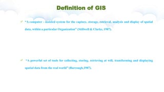
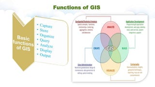
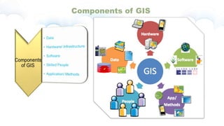
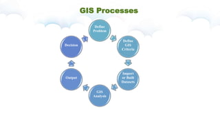
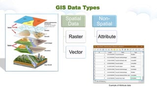
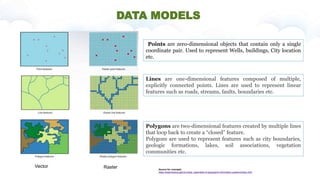
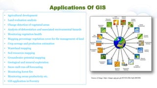
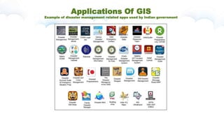
lecture by: Vrushali Kadam
Definition of GIS
“A computer - assisted system for the capture, storage, retrieval, analysis and display of spatial
data, within a particular Organization” (Stillwell & Clarke, 1987).
“A powerful set of tools for collecting, storing, retrieving at will, transforming and displaying
spatial data from the real world” (Burrough,1987).
GIS in everyday life
Functions of GIS
Components of GIS
GIS Processes
Define
Problem
Define
GIS
Criteria
Import
or Built
Datasets
GIS
Analysis
Output
Decision
GIS Data Types
Spatial
Data
Raster
Vector
Non-
Spatial
Attribute
Example of Attribute data
DATA MODELS
Points are zero-dimensional objects that contain only a single
coordinate pair. Used to represent Wells, buildings, City location
etc.
Lines are one-dimensional features composed of multiple,
explicitly connected points. Lines are used to represent linear
features such as roads, streams, faults, boundaries etc.
Polygons are two-dimensional features created by multiple lines
that loop back to create a “closed” feature.
Polygons are used to represent features such as city boundaries,
geologic formations, lakes, soil associations, vegetation
communities etc.
Source for concepts:
https://saylordotorg.github.io/text_essentials-of-geographic-information-systems/index.html
Vector Raster
Applications Of GIS
• Agricultural development
• Land evaluation analysis
• Change detection of vegetated areas
• Analysis of deforestation and associated environmental hazards
• Monitoring vegetation health
• Mapping percentage vegetation cover for the management of land
• Crop acreage and production estimation
• Wasteland mapping
• Soil resources mapping
• Groundwater potential mapping
• Geological and mineral exploration
• Snow-melt run-off forecasting
• Monitoring forest fire
• Monitoring ocean productivity etc.
• GIS application in Forestry
Source of Image: https://images.app.goo.gl/cWYHUZMvTpK1BWH96
Applications Of GIS
Example of disaster management related apps used by Indian government
Other example from the information industries
Source of Image:
https://www.esri.com/news/arcnews/summer11articles/open-rest-standard-lets-you-author-and-use-map-and-gis-services-almost-anywhere.html
Introduction to gis

Introduction to gis

  • 1.
  • 2.
    Definition of GIS “Acomputer - assisted system for the capture, storage, retrieval, analysis and display of spatial data, within a particular Organization” (Stillwell & Clarke, 1987). “A powerful set of tools for collecting, storing, retrieving at will, transforming and displaying spatial data from the real world” (Burrough,1987).
  • 3.
  • 4.
  • 5.
  • 6.
  • 7.
  • 8.
    DATA MODELS Points arezero-dimensional objects that contain only a single coordinate pair. Used to represent Wells, buildings, City location etc. Lines are one-dimensional features composed of multiple, explicitly connected points. Lines are used to represent linear features such as roads, streams, faults, boundaries etc. Polygons are two-dimensional features created by multiple lines that loop back to create a “closed” feature. Polygons are used to represent features such as city boundaries, geologic formations, lakes, soil associations, vegetation communities etc. Source for concepts: https://saylordotorg.github.io/text_essentials-of-geographic-information-systems/index.html Vector Raster
  • 9.
    Applications Of GIS •Agricultural development • Land evaluation analysis • Change detection of vegetated areas • Analysis of deforestation and associated environmental hazards • Monitoring vegetation health • Mapping percentage vegetation cover for the management of land • Crop acreage and production estimation • Wasteland mapping • Soil resources mapping • Groundwater potential mapping • Geological and mineral exploration • Snow-melt run-off forecasting • Monitoring forest fire • Monitoring ocean productivity etc. • GIS application in Forestry Source of Image: https://images.app.goo.gl/cWYHUZMvTpK1BWH96
  • 10.
    Applications Of GIS Exampleof disaster management related apps used by Indian government
  • 11.
    Other example fromthe information industries Source of Image: https://www.esri.com/news/arcnews/summer11articles/open-rest-standard-lets-you-author-and-use-map-and-gis-services-almost-anywhere.html