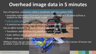
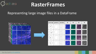
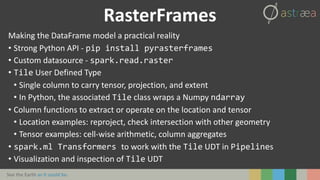
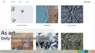
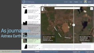
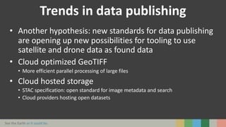
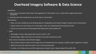
See the Earth as it could be. 1
BringSatellite&DroneImageryintoYour
DataScienceWorkflows
Jason Brown
Senior Data Scientist, Astraea, Inc.
Spark+AI Summit 2020
June 26, 2020
See the Earth as it could be. Credit: Daily Overview
See the Earth as it could be. Credit: Astraea & Jamie Conklin
See the Earth as it could be.
Credit: Aviation Geek Club
See the Earth as it could be.
Credit: US NASA
See the Earth as it could be.
Big data
Variety:
• Naming? Overhead imagery, Earth observation, remote
sensing, raster
• > 150 file formats
Velocity:
• European Space Agency Sentinel-2 mission generating
~6TB per day
• Government operators in USA, Europe, Japan, South
Korea, China, Brazil
• Worldwide private organizations operating hundreds
satellites
Volume:
• 2 years ago, US NASA archives at 30 PB and growing
• Plus other public and private operators
• Plus drones
Open data policies (US, EU) and open standards for cloud
access
Source: US NASA
US NASA EOSDIS Data Volumes (PB)
See the Earth as it could be.
What about data science?
Long standing open source software for overhead imagery has
produced well developed but narrow tools
• QGIS: visual desktop app for cartography, processing of image to
enable human interpretation
• Geospatial Data Abstraction Library (GDAL): mature, high quality
open source C and C++ API
• GDAL programs: higher level operations, file I/O orientation
Necessary but not sufficient for data science
RasterFrames origin story:
• What makes overhead imagery “special”?
• How can we work with Volume of imagery in general-purpose tools?
See the Earth as it could be.
Overhead image data in 5 minutes
Starting from array or tensor representation of image data
What is different?
• Typical sizes 50-150 megapixel
• Each channel typically 16-bit integers (at rest), often interpreted as float
• Arbitrary number of channels representing more parts of electromagnetic
spectrum: e.g. ultraviolet, infrared, etc.
What is additional?
• Location!
• More metadata on each image: sensor, capture time, processing details from
publisher
• Encoding NaN in the integer values with a sentinel value
See the Earth as it could be.
Overhead image data in 5 minutes
Has a Projection, sometimes called a coordinate reference system (CRS)
• Invertible mathematical functions to convert coordinate on a 2D plane to/from a
location on the surface of an earth model
• Link to video explaining projections
• In practice we reference these with string representation
Has an affine transform to convert tensor index to/from 2D plane coordinates
• Translation: defines projection coordinate of 0, 0 index
• Scale: defines size of each cell in the 2D plane
• Shear: rarely seen in practice
Without shear, we can equivalently express the affine transform for a tensor of known size
as extent, a pair of 2D coordinates
See the Earth as it could be.
RasterFrames
Representing large image files in a DataFrame
See the Earth as it could be.
RasterFrames
Making the DataFrame model a practical reality
• Strong Python API - pip install pyrasterframes
• Custom datasource - spark.read.raster
• Tile User Defined Type
• Single column to carry tensor, projection, and extent
• In Python, the associated Tile class wraps a Numpy ndarray
• Column functions to extract or operate on the location and tensor
• Location examples: reproject, check intersection with other geometry
• Tensor examples: cell-wise arithmetic, column aggregates
• spark.ml Transformers to work with the Tile UDT in Pipelines
• Visualization and inspection of Tile UDT
See the Earth as it could be.
Github Gist
https://gist.github.com/vpipkt/09734d56082e7c74b187e9a635b6e764
Case study
See the Earth as it could be.
Currently incubating under Eclipse Foundation LocationTech
• Open source under Apache 2.0 license and commercial friendly intellectual
property governance
Try it:
• https://rasterframes.io/getting-started.html
• https://pypi.org/project/pyrasterframes/
• Free trial of EarthAI Notebook
Contribute!
• gitter.im for questions, engaging with ideas to contribute
https://gitter.im/locationtech/rasterframes
• GitHub for tracking issues & pull requests
• https://github.com/locationtech/rasterframes/blob/develop/CONTRIBUTING.md
RasterFrames project
See the Earth as it could be. 14
Thank you!
Visit https://rasterframes.io to try it out!
Date
See the Earth as it could be.
Trends in data publishing
• Another hypothesis: new standards for data publishing
are opening up new possibilities for tooling to use
satellite and drone data as found data
• Cloud optimized GeoTIFF
• More efficient parallel processing of large files
• Cloud hosted storage
• STAC specification: open standard for image metadata and search
• Cloud providers hosting open datasets
See the Earth as it could be.
Overhead Imagery Software & Data Science
Hypotheses:
1. Data science innovations often driven from application of “found data”. E.g. 1 million Flickr images lead to facial
recognition
2. Specialist tools have hindered the use of this data as “found data”
Observations:
• Many use cases satisfied by visual desktop apps for cartography, processing of image to enable human interpretation
• Typical science use case focuses on a small region, often very sophisticated processing of the data
• Science use cases well met by Geospatial Data Abstraction Library (GDAL) API
• GDAL
• Advantages: mature, high quality open source C and C++ API
• Disadvantages: higher level tools are oriented to Unix style read-process-write
• Data science, found data, and overhead imagery
• Data scientist needs to inspect some images but not a feasible tactic for creating a scalable model / algorithm / analytic
• Need to do some file reads, but want to use in memory processing
• In reality, a lot of data science and ML engineering is already done in Apache Spark SQL and ML APIs
See the Earth as it could be. 17Date

Bring Satellite and Drone Imagery into your Data Science Workflows

  • 1.
    See the Earthas it could be. 1 BringSatellite&DroneImageryintoYour DataScienceWorkflows Jason Brown Senior Data Scientist, Astraea, Inc. Spark+AI Summit 2020 June 26, 2020
  • 2.
    See the Earthas it could be. Credit: Daily Overview
  • 3.
    See the Earthas it could be. Credit: Astraea & Jamie Conklin
  • 4.
    See the Earthas it could be. Credit: Aviation Geek Club
  • 5.
    See the Earthas it could be. Credit: US NASA
  • 6.
    See the Earthas it could be. Big data Variety: • Naming? Overhead imagery, Earth observation, remote sensing, raster • > 150 file formats Velocity: • European Space Agency Sentinel-2 mission generating ~6TB per day • Government operators in USA, Europe, Japan, South Korea, China, Brazil • Worldwide private organizations operating hundreds satellites Volume: • 2 years ago, US NASA archives at 30 PB and growing • Plus other public and private operators • Plus drones Open data policies (US, EU) and open standards for cloud access Source: US NASA US NASA EOSDIS Data Volumes (PB)
  • 7.
    See the Earthas it could be. What about data science? Long standing open source software for overhead imagery has produced well developed but narrow tools • QGIS: visual desktop app for cartography, processing of image to enable human interpretation • Geospatial Data Abstraction Library (GDAL): mature, high quality open source C and C++ API • GDAL programs: higher level operations, file I/O orientation Necessary but not sufficient for data science RasterFrames origin story: • What makes overhead imagery “special”? • How can we work with Volume of imagery in general-purpose tools?
  • 8.
    See the Earthas it could be. Overhead image data in 5 minutes Starting from array or tensor representation of image data What is different? • Typical sizes 50-150 megapixel • Each channel typically 16-bit integers (at rest), often interpreted as float • Arbitrary number of channels representing more parts of electromagnetic spectrum: e.g. ultraviolet, infrared, etc. What is additional? • Location! • More metadata on each image: sensor, capture time, processing details from publisher • Encoding NaN in the integer values with a sentinel value
  • 9.
    See the Earthas it could be. Overhead image data in 5 minutes Has a Projection, sometimes called a coordinate reference system (CRS) • Invertible mathematical functions to convert coordinate on a 2D plane to/from a location on the surface of an earth model • Link to video explaining projections • In practice we reference these with string representation Has an affine transform to convert tensor index to/from 2D plane coordinates • Translation: defines projection coordinate of 0, 0 index • Scale: defines size of each cell in the 2D plane • Shear: rarely seen in practice Without shear, we can equivalently express the affine transform for a tensor of known size as extent, a pair of 2D coordinates
  • 10.
    See the Earthas it could be. RasterFrames Representing large image files in a DataFrame
  • 11.
    See the Earthas it could be. RasterFrames Making the DataFrame model a practical reality • Strong Python API - pip install pyrasterframes • Custom datasource - spark.read.raster • Tile User Defined Type • Single column to carry tensor, projection, and extent • In Python, the associated Tile class wraps a Numpy ndarray • Column functions to extract or operate on the location and tensor • Location examples: reproject, check intersection with other geometry • Tensor examples: cell-wise arithmetic, column aggregates • spark.ml Transformers to work with the Tile UDT in Pipelines • Visualization and inspection of Tile UDT
  • 12.
    See the Earthas it could be. Github Gist https://gist.github.com/vpipkt/09734d56082e7c74b187e9a635b6e764 Case study
  • 13.
    See the Earthas it could be. Currently incubating under Eclipse Foundation LocationTech • Open source under Apache 2.0 license and commercial friendly intellectual property governance Try it: • https://rasterframes.io/getting-started.html • https://pypi.org/project/pyrasterframes/ • Free trial of EarthAI Notebook Contribute! • gitter.im for questions, engaging with ideas to contribute https://gitter.im/locationtech/rasterframes • GitHub for tracking issues & pull requests • https://github.com/locationtech/rasterframes/blob/develop/CONTRIBUTING.md RasterFrames project
  • 14.
    See the Earthas it could be. 14 Thank you! Visit https://rasterframes.io to try it out! Date
  • 15.
    See the Earthas it could be. Trends in data publishing • Another hypothesis: new standards for data publishing are opening up new possibilities for tooling to use satellite and drone data as found data • Cloud optimized GeoTIFF • More efficient parallel processing of large files • Cloud hosted storage • STAC specification: open standard for image metadata and search • Cloud providers hosting open datasets
  • 16.
    See the Earthas it could be. Overhead Imagery Software & Data Science Hypotheses: 1. Data science innovations often driven from application of “found data”. E.g. 1 million Flickr images lead to facial recognition 2. Specialist tools have hindered the use of this data as “found data” Observations: • Many use cases satisfied by visual desktop apps for cartography, processing of image to enable human interpretation • Typical science use case focuses on a small region, often very sophisticated processing of the data • Science use cases well met by Geospatial Data Abstraction Library (GDAL) API • GDAL • Advantages: mature, high quality open source C and C++ API • Disadvantages: higher level tools are oriented to Unix style read-process-write • Data science, found data, and overhead imagery • Data scientist needs to inspect some images but not a feasible tactic for creating a scalable model / algorithm / analytic • Need to do some file reads, but want to use in memory processing • In reality, a lot of data science and ML engineering is already done in Apache Spark SQL and ML APIs
  • 17.
    See the Earthas it could be. 17Date