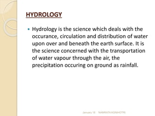
This document discusses hydrology and the hydrological cycle. It defines hydrology as the science dealing with the occurrence, circulation and distribution of water on Earth. The key points made are:
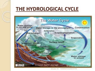
- The hydrological cycle describes the continuous movement of water on, above and below the surface of the Earth, including evaporation, transpiration, precipitation, collection in lakes, rivers and oceans, and underground storage.
- The main processes in the hydrological cycle are evaporation, transpiration, condensation, precipitation, collection and storage of water as freshwater in rivers, lakes, groundwater etc. This cycle replenishes and purifies the water sources on Earth.
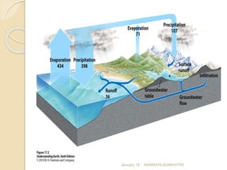
- Precipitation, runoff,
Hydrology means science of water.
It is the science that deals with the occurance, circulation and distribution of water on the earth.
Hydrology is a broad subject of an inter-disciplinary nature drawing support from allied sciences.
It is a topic from Engineering Hydrology authored by Raghunath. It was my report when I took up this subject on 2nd semester, 2014-2015 during my 4th year level. It was under my instructor, Engr. Bernadeth V. Dapun, MERIE
this is my presentation of hydraulic and water resources engineering. I have discussed in this ppt about network density for given rain gauge and calculations and index of witness.
1. Ground Water Occurrence
2. Types of Aquifers
3. Aquifer Parameters
4. Darcy’s Law
5. Measurement of Coefficient of Permeability of Soil
6. Types of Wells
7. Well Construction
8. Well Development
Hydrological cycle- Meteorological measurements – Requirements, types and forms of Precipitation-Rain Gauges-Spatial analysis of rainfall data using Thiessen and Isohyetal methods Infiltration-Infiltration Index-Interception-Evaporation, Watershed, catchment and basin - Catchment characteristics - factors affecting runoff – Runoff estimation using empirical
Stream flow representing the runoff phase of the hydrologic cycle is the most important basic data for hydrologic studies. Runoff is generated by rainstorms. Its occurrence and quantity are dependent on the characteristics of the rainfall event, i.e. intensity, duration and distribution. This module highlights about runoff components of the hydrological cycle.
An aquifer is an underground layer of water-bearing rock. Water-bearing rocks are permeable, meaning that they have openings that liquids and gases can pass through. Sedimentary rock such as sandstone, as well as sand and gravel, are examples of water-bearing rock.
Stream Gauging: Necessity; Selection of gauging sites; Methods of discharge measurement; Area-Velocity method; Venturi flume; Chemical method; weir method; Measurement of velocity; Floats Surface float, Sub–surface float or Double float, Twin float, Velocity rod or Rod float; Pitot tube; Current meter; Working of current meter; rating of current meter; Measurement of area of flow; Measurement of width - Pivot point method; Measurement of depth Sounding rod, Echo- sounder.
The term precipitation is also used to refer all forms of falling moisture viz., rainfall, snowfall, sleet, hail etc. Rainfall occurs in the form of a pattern. Atmospheric Precipitation is a wonderful process for the whole globe to use. This module explains it in general.
very nice and amazingnsnznznzjzjzjzjznznznnzznznznznznznnznznsnznznznznznzznnsnzsnnznznznznznznzjznsnzjsnsnzifnekaolNcnfekaoLmxfnfbkslks siwnd siw sbxhw sus w by sq sbsjdjzixns js wis js wjz sus sbxis jswb sus s sjcne sjs s sjz w aix w sjz sjz s wuz d eusnd sj xxjbs sus ebsbe dhs dhssssssbs dbs shs dbd snz shs s sjs snsb snsjs shs sns sjsbjz wus shx sus shs xh shz shs shs shs shs hs shs shs ßhs sjnshs sjsnsjsnhssnhsdbwbe dhsndj shd shd ujsnsid sjsndjd sjsnxbsbs bs dnx s him sjs xbs sh sndsbs shsnsbs sz
Precipitation is the natural process of conversion of atmospheric water vapour into water. The water falls(comes down) in the form of a rainfall or snow fall. The term precipitation is also used to refer rainfall. It is term and includes all forms of falling moisture viz., rainfall, snowfall, sleet, hail etc. Rainfall occurs in the form of a pattern.
chapter 2.ppt ,hydrological study of ethi0mulugeta48
hydrology ,A programme of groundwater investigations is to obtain information on the resource through systematic collection, synthesis, interpretation and compilation of data.
It seeks information on its occurrence, movement, storage, recharge, discharge, quality & quantity.
It includes the study of its geological, environmental, as well as the hydrologic and hydraulic aspects of its flow system.
Geologic Methods
A geologic investigation begins with the collection, analysis, and hydrogeologic interpretation of existing topographic map, aerial photographs, geologic maps and logs, and other pertinent records.
This should be supplemented, when possible, by geologic field reconnaissance and by evaluation of available hydrologic data on: stream flow and springs; well yields; groundwater recharge & levels; and water quality
Welcome to WIPAC Monthly the magazine brought to you by the LinkedIn Group Water Industry Process Automation & Control.
In this month's edition, along with this month's industry news to celebrate the 13 years since the group was created we have articles including
A case study of the used of Advanced Process Control at the Wastewater Treatment works at Lleida in Spain
A look back on an article on smart wastewater networks in order to see how the industry has measured up in the interim around the adoption of Digital Transformation in the Water Industry.
Explore the innovative world of trenchless pipe repair with our comprehensive guide, "The Benefits and Techniques of Trenchless Pipe Repair." This document delves into the modern methods of repairing underground pipes without the need for extensive excavation, highlighting the numerous advantages and the latest techniques used in the industry.
Learn about the cost savings, reduced environmental impact, and minimal disruption associated with trenchless technology. Discover detailed explanations of popular techniques such as pipe bursting, cured-in-place pipe (CIPP) lining, and directional drilling. Understand how these methods can be applied to various types of infrastructure, from residential plumbing to large-scale municipal systems.
Ideal for homeowners, contractors, engineers, and anyone interested in modern plumbing solutions, this guide provides valuable insights into why trenchless pipe repair is becoming the preferred choice for pipe rehabilitation. Stay informed about the latest advancements and best practices in the field.
Saudi Arabia stands as a titan in the global energy landscape, renowned for its abundant oil and gas resources. It's the largest exporter of petroleum and holds some of the world's most significant reserves. Let's delve into the top 10 oil and gas projects shaping Saudi Arabia's energy future in 2024.
NO1 Uk best vashikaran specialist in delhi vashikaran baba near me online vas...Amil Baba Dawood bangali
Contact with Dawood Bhai Just call on +92322-6382012 and we'll help you. We'll solve all your problems within 12 to 24 hours and with 101% guarantee and with astrology systematic. If you want to take any personal or professional advice then also you can call us on +92322-6382012 , ONLINE LOVE PROBLEM & Other all types of Daily Life Problem's.Then CALL or WHATSAPP us on +92322-6382012 and Get all these problems solutions here by Amil Baba DAWOOD BANGALI
#vashikaranspecialist #astrologer #palmistry #amliyaat #taweez #manpasandshadi #horoscope #spiritual #lovelife #lovespell #marriagespell#aamilbabainpakistan #amilbabainkarachi #powerfullblackmagicspell #kalajadumantarspecialist #realamilbaba #AmilbabainPakistan #astrologerincanada #astrologerindubai #lovespellsmaster #kalajaduspecialist #lovespellsthatwork #aamilbabainlahore#blackmagicformarriage #aamilbaba #kalajadu #kalailam #taweez #wazifaexpert #jadumantar #vashikaranspecialist #astrologer #palmistry #amliyaat #taweez #manpasandshadi #horoscope #spiritual #lovelife #lovespell #marriagespell#aamilbabainpakistan #amilbabainkarachi #powerfullblackmagicspell #kalajadumantarspecialist #realamilbaba #AmilbabainPakistan #astrologerincanada #astrologerindubai #lovespellsmaster #kalajaduspecialist #lovespellsthatwork #aamilbabainlahore #blackmagicforlove #blackmagicformarriage #aamilbaba #kalajadu #kalailam #taweez #wazifaexpert #jadumantar #vashikaranspecialist #astrologer #palmistry #amliyaat #taweez #manpasandshadi #horoscope #spiritual #lovelife #lovespell #marriagespell#aamilbabainpakistan #amilbabainkarachi #powerfullblackmagicspell #kalajadumantarspecialist #realamilbaba #AmilbabainPakistan #astrologerincanada #astrologerindubai #lovespellsmaster #kalajaduspecialist #lovespellsthatwork #aamilbabainlahore #Amilbabainuk #amilbabainspain #amilbabaindubai #Amilbabainnorway #amilbabainkrachi #amilbabainlahore #amilbabaingujranwalan #amilbabainislamabad
Industrial Training at Shahjalal Fertilizer Company Limited (SFCL)MdTanvirMahtab2
This presentation is about the working procedure of Shahjalal Fertilizer Company Limited (SFCL). A Govt. owned Company of Bangladesh Chemical Industries Corporation under Ministry of Industries.
Final project report on grocery store management system..pdfKamal Acharya
In today’s fast-changing business environment, it’s extremely important to be able to respond to client needs in the most effective and timely manner. If your customers wish to see your business online and have instant access to your products or services.
Online Grocery Store is an e-commerce website, which retails various grocery products. This project allows viewing various products available enables registered users to purchase desired products instantly using Paytm, UPI payment processor (Instant Pay) and also can place order by using Cash on Delivery (Pay Later) option. This project provides an easy access to Administrators and Managers to view orders placed using Pay Later and Instant Pay options.
In order to develop an e-commerce website, a number of Technologies must be studied and understood. These include multi-tiered architecture, server and client-side scripting techniques, implementation technologies, programming language (such as PHP, HTML, CSS, JavaScript) and MySQL relational databases. This is a project with the objective to develop a basic website where a consumer is provided with a shopping cart website and also to know about the technologies used to develop such a website.
This document will discuss each of the underlying technologies to create and implement an e- commerce website.
Hierarchical Digital Twin of a Naval Power SystemKerry Sado
A hierarchical digital twin of a Naval DC power system has been developed and experimentally verified. Similar to other state-of-the-art digital twins, this technology creates a digital replica of the physical system executed in real-time or faster, which can modify hardware controls. However, its advantage stems from distributing computational efforts by utilizing a hierarchical structure composed of lower-level digital twin blocks and a higher-level system digital twin. Each digital twin block is associated with a physical subsystem of the hardware and communicates with a singular system digital twin, which creates a system-level response. By extracting information from each level of the hierarchy, power system controls of the hardware were reconfigured autonomously. This hierarchical digital twin development offers several advantages over other digital twins, particularly in the field of naval power systems. The hierarchical structure allows for greater computational efficiency and scalability while the ability to autonomously reconfigure hardware controls offers increased flexibility and responsiveness. The hierarchical decomposition and models utilized were well aligned with the physical twin, as indicated by the maximum deviations between the developed digital twin hierarchy and the hardware.
2. HYDROLOGY
Hydrology is the science which deals with the
occurance, circulation and distribution of water
upon over and beneath the earth surface. It is
the science concerned with the transportation
of water vapour through the air, the
precipitation occuring on ground as rainfall.
January 18 NAMRATA AGNIHOTRI
7. The hydrological cycle is the descriptive term
applied to the circulation of water from the
ocean to the atmosphere to the ground and
back to the ocean again. Thus hydrological cycle
is the earths water circulatory system.
January 18 NAMRATA AGNIHOTRI
8. The water from the surface sources like lakes, river,
ocean etc converts to vapour by evaporation due to
solar heat. The vapour goes on accumulating
continuously in the atmosphere. This vapour is
again condensed due to sudden fall in temperature
and pressure. Thus clouds are formed. These
clouds again cause the precipitation (i.e. rainfall).
Some of the vapour is converted to ice at the peak
of the mountains. The ice again melts in summer
and flows as rivers to meet the sea or ocean. These
processes of evaporation, precipitation and melting
of ice go on continuously like an endless chain and
thus a balance is maintained in the atmosphere.
This phenomenon is known as hydrologic cycle.
January 18 NAMRATA AGNIHOTRI
10. Definition
All types of moisture reaching the surface of earth
from atmosphere.
Precipitation is the basic input to the hydrology.
Factors determining
precipitation or the
amount of atmospheric
moisture over a region
Climate
Geography
Ocean surfaces is the
chief source of moisture
for precipitation
January 18 NAMRATA AGNIHOTRI
12. Rain
Rain is the most common type of
precipitation in our atmosphere. Rain
is when liquid droplets fall to the
surface of the Earth.
There are two different forms of rain,
either in the form of
showers
drizzles
Showers are heavy, large drops of rain
and usually only last a period of time.
Drizzles however usually last longer
and are made up of smaller droplets
of water.
Rain can either be formed as ice
crystals melt or it can be smaller water
droplets.
Light
I = 2.5mm/hr
Moderate
I = 2.8-7.6mm/hr
Heavy
I > 7.6 mm/hr
January 18 NAMRATA AGNIHOTRI
13. Snow
Snow is the second most common
precipitation in the North East.
Snow forms when water vapor turns directly
into ice without ever passing through a liquid
state. This happens as water condenses
around an ice crystal.
Density of freshly fallen
snow varies between 125-
500mm of snow required
to equal 25mm of liquid
water
Average density (specific
gravity) = 0.1
January 18 NAMRATA AGNIHOTRI
14. Hail
Hail is created when moisture and wind are together.
Inside the cumulonimbus clouds ice crystals form, and
begin to fall towards the surface of Earth. When this starts
to happen wind gusts start to pick up the ice crystals
pushing them up high into the clouds. As they start to fall
down again they continue to grow in size. A wind gust
might catch the hail stone again which will push it back up
into the cloud. This whole process gets repeated several
times before the hail stone becomes so big that it is too
heavy for the wind to carry so it must fall towards Earth.
Shapes of hail particles
1. Spherical
2. Conical
3. Irregular
Diameter range 5 to 125 mm
Specific gravity = 0.8
Average density (specific gravity) =
0.1 January 18 NAMRATA AGNIHOTRI
15. Fog
There are four main types of fog,
radiation fog
advection fog
upslope fog
evaporation fog
There is really no different between fog and the
clouds that are high in the sky. In simple terms
fog is; a cloud that has formed near the surface
of the Earth.
January 18 NAMRATA AGNIHOTRI
16. Dew
The small drops of water which can be found
on cool surfaces like grass in the morning.
This is the result of atmospheric vapor
condensing on the surface in the colder night
air.
Dew Point is the temperature in which
condensation starts to take place or when dew
is created.
January 18 NAMRATA AGNIHOTRI
17. Mist / Drizzle
Mist is a bunch of small droplets of water which are
in the air. This occurs with cold air when it is above
a warm surface, for example water.
Fog and mist are very similar, the only difference is
their visibility.
If you cannot see 1 kilometer or less you know you're
dealing with fog.
You can see visuals through mist and it is
more haze looking than a thicker substance.
Diameter range between 0.1
and 0.5 mm/hr
January 18 NAMRATA AGNIHOTRI
18. Glaze
Glaze is the ice coating, generally clear
and smooth, formed on exposed
surfaces by the freezing of super cooled
water deposited by rain or drizzle.
January 18 NAMRATA AGNIHOTRI
19. Sleet
Sleet consists of transparent, globular,
solid grains of ice formed by the freezing of
raindrops or freezing of largely melted ice
crystals falling through a layer of sub
freezing air near the earth’s surface.
January 18 NAMRATA AGNIHOTRI
20. Arithmetic Mean Method
Arithmetic mean method is used when
normal annual precipitation is within 10%
of the gauge for which data are being
reconstructed. This method is least
accurate however.
Where:
Pm = precipitation at the missing location
Pi = precipitation at index station I
N = number of rain gauges
January 18 NAMRATA AGNIHOTRI
21. Theissen Polygon Method
Divide the region (area A)
into sub-regions centred
about each rain gauge;
Determine the area of each
sub-region (Ai) and compute
sub-region weightings (Wi)
using: Wi = Ai/A
Compute total aerial rainfall
using Rainfall recorded at
each station is given a
weight age based on the
area closest to the station.
January 18 NAMRATA AGNIHOTRI
22. Theissen Polygon Method
Consider a catchment area with say, 3
rain gauge stations. Let there be 3
stations outside the catchment, but
in its neighborhood. Catchment
area is drawn to scale and position
of these 6 stations is plotted on it.
Stations are joined so as to get a
network of triangles. Perpendicular
bisectors are drawn to each of the
sides of these triangles. These
bisectors form a polygon around
each station. If the boundary of
catchment cuts the bisectors, then
boundary is taken as outer limit of
polygon. These bounding polygons
are called Thiessen Polygons. The
area of these polygons is measured
with a planimeter or by grid overlay
January 18 NAMRATA AGNIHOTRI
23. Isohytal Method
Plot gauge locations
on a map;
Subjectively
interpolate between
rain amounts
between gauges at a
selected interval;
Connect points of
equal rain depth to
produce lines of
equal rainfall
amounts (isohyets);
January 18 NAMRATA AGNIHOTRI
24. Isohytal Method
Compute aerial rain using Isohyets –
It is a line joining points of equal rainfall
magnitude.
The catchment area is drawn to scale
and the rain gauge stations are marked
on it. The recorded rainfall values for
which aerial average is to determined
are marked at the respective stations.
Neighboring stations outside the
catchment are also considered. Taking
point rainfall values as the guide,
isohyets of different rainfall values are
drawn (similar to drawing contours
based on spot levels.
The area between adjacent isohyets is
measured using a planimeter. If
isohyets go out of the catchment, the
catchment boundary is used as the
bounding line.
It is assumed that the average value of
rainfall indicated by two isohyets acts
over the inter isohytal area
January 18 NAMRATA AGNIHOTRI
25. RUNOFF:
Runoff is that part of precipitation that is not
evaporated.
When moisture falls to the earth’s surface as
precipitation a part of it is evaporated from the water
surface soil and vegetation and through transpiration by
plants and the remainder precipitation is available as
runoff.
January 18 NAMRATA AGNIHOTRI
26. Factors Affecting Runoff:
The main factors affecting runoff are:
1. Precipitation characteristics.
2. Shape and size of the catchment.
3. Topography
4. Geological characteristics of the catchment.
5. Meterological characteristics
6. Character of the catchment surface
7. Storage characteristics of the catchment.
January 18 NAMRATA AGNIHOTRI
27. Precipitation characteristics:
The important characteristics of precipitation are:
i. Intensity of rainfall
ii. Duration of rainfall
iii. Form of precipitation
iv. Direction of storm movement etc.
Runoff increases with the intensity of rainfall. The more the
rainfall, more will be the runoff. Also the rainfall for a longer
duration would produce greater runoff.
The precipitation may occur either in the form of rain or
snow. If the precipitation occurs in the form of rain, it will
immediately produce the runoff but if the precipitation occurs
in the form of snow, it will produce the runoff much later.
January 18 NAMRATA AGNIHOTRI
28. Shape and size of the
catchment:
The runoff is considerably affected by the shape and size
of the catchment.
A drainage basin may be either fan shaped of fern-
leaf shaped. In case of fan shaped catchment, all the
tributaries are approximately of the same size. Such
catchment gives greater runoff since peak flood from the
tributaries is likely to reach the main stream
approximately at the time.
In the case of fern-leaf shaped catchment the
tributaries are generally of different lengths, and meet the
main stream at the regular intervals. In such a narrow
catchment, the peak flood intensity is reduced.
January 18 NAMRATA AGNIHOTRI
29. Topography
The topography of the catchment area has
significant effect on the runoff. A steeply sloping
drainage basin produces greater runoff because a
steep slope helps quicker drainage no depression
storage and less evaporation losses.
If the catchment is mountainous and is located on
the windward side the intensity of rainfall is more
and hence the runoff is more.
January 18 NAMRATA AGNIHOTRI
30. Geological characteristic of
the catchment
If the surface soil and sub surface is pervious
seepage will be more and this in turn reduce
the peak flood. If the surface is rocky the water
absorption will be less and runoff will be more.
January 18 NAMRATA AGNIHOTRI
31. Meteorological characteristic
Higher temperature and higher wind velocity
cause more losses due to evaporation and
transpiration and reduces the runoff. On the
other hand greater humidity decrease
evaporation and transpiration losses resulting in
greater runoff.
January 18 NAMRATA AGNIHOTRI
32. Computation of runoff
The runoff from the catchment can be
computed daily, monthly or yearly.
By empirical formulae and table:
runoff coefficient:
R= kP
k= R/P
R= runoff
P= precipitation
k= runoff corfficient
January 18 NAMRATA AGNIHOTRI
33. Evaporation : it is the process in which water is
changed to vapours at the free surface below the
boiling point of water through the transfer of heat
it is the continuous process by which a substance
changes from liquid to gaseous state.
Transpiration : it is the process of water being
lost from the leaves of the plants from their
pores.
January 18 NAMRATA AGNIHOTRI
34. Factors affecting evaporation
1) Temperature of air:
the evaporation increase with
an increase in air temperature. Thus, in summer
seasons or in hot countries the evaporation will
be more as compared to that in the winter season
or in clod countries.
2) Wind velocity:
if the velocity of air is more, the
saturated film of air containing the water vapour
will move easily, causing evaporation.
January 18 NAMRATA AGNIHOTRI
35. 3) Atmospheric pressure:
a decrease in
atmospheric pressure increase the rate of
evaporation because there are fewer
molecules in the air above the free surface
to cause the interference.
4) Nature of evaporating surface:
different evaporating
surfaces like soil, barren land, forest area,
houses, lakes, affect evaporation to the
extent they have the potential.
January 18 NAMRATA AGNIHOTRI
36. 5) Area of water surface:
the amount of evaporation is
directly proportional to the area of evaporation. If
the exposed area is large the evaporation will be
more and vise versa.
6) Depth of the body:
the depth of water influences the
evaporation considerably. Deep water body
evaporate slower than the shallow water bodies
in summer while in winter season they evaporate
faster.
January 18 NAMRATA AGNIHOTRI
37. 7) Humidity :
evaporation is inversely proportional to
humidity. If the humidity in the atmosphere is
more evaporation will be less.
8) Impurities in water:
any dissolved salts in water
reduces the saturated vapour pressure of water
which consequently reduces the rate of
evaporation
January 18 NAMRATA AGNIHOTRI