SlideShare a Scribd company logo
1 of 46
Water molecules have been
transferred time and time again
from the oceans and the land
surface into the atmosphere by
evaporation, dropped on the
land as precipitation, and
transferred back to the sea by
rivers and groundwater. This
endless circulation is known as
the "hydrologic cycle".
0- Evaporation from Ocean
1- Raindrop evaporation
2- Interception
3- Transpiration
4- Evaporation from land
5- Evaporation from water
bodies
6- Surface runoff
7- Infiltration
8- Ground water
Deep percolation
Precipitation: The term precipitation denotes all forms of water
that reached the earth’s surface from atmosphere. Rain,
drizzle, hail and snow are examples of precipitation.
Causes of precipitation: It is necessary that the moist air masses
to cool in order to condense. This is generally accomplished by
adiabatic cooling of moist air through a process of being lifted to
higher altitudes.
Types of precipitation:
 Frontal precipitation: This is the precipitation that is caused by
the expansion of air on ascent along or near a frontal surface.
Convective precipitation: Precipitation caused by the
upward movement of air which is warmer than its
surroundings. This precipitation is generally showery
nature with rapid changes of intensities.
Orographic precipitation: Precipitation caused by the
air masses which strike the mountain barriers and rise
up, causing condensation and precipitation. The
greatest amount of precipitation will fall on the
windward side of the barrier and little amount of
precipitation will fall on leave ward side.
Forms of precipitation:
• Rain- It is used to describe precipitation in the form of
water drops of sizes in the range of 0.5mm to 6mm.
• Snow- It consists of ice crystals which usually combine
to form flakes.
• Drizzle- It is fine sprinkle of numerous water droplets of
size less than 0.5mm and intensity less than 1.5mm/hr.
• Glaze- When rain or drizzle comes in contact with cold ground at
around 0° C, the water drop freezes to form an ice coating called as
Glaze.
• Sleet- It is frozen raindrops of transparent grains which forms when
rain falls through air at subfreezing temperature.
• Hail- It is a showery precipitation in the term of ice of size more than
8mm.
• Dew- It forms directly by conensastion on the ground mainly during
the night when the surface has been cooled by outgoing radiation.
2- Weighting Bucket rain gauge.
Measurement of Precipitation:
(a)- Recording Type :
1- Tipping Bucket rain gauge.
3- Siphon Rain gauge.
(b)- Non-Recording Type
Analysis and Interpretation of precipitation Data:
1- Intensity: It is a measure of quantity of rain falling in a given
time in a specific area. It is usually expressed in mm/hr.
2- Duration: It is a period of time during which Rainfall occurs.
3- Frequency: This refers to the probability that given depth of
Rainfall which will fall in a given time.
4- Areal extent: This concerns the area over which a point
Rainfall can be held to apply.
5- Rainfall mass curve: It is plot of cumulative Rainfall against Time.
Slope of the tangent drawn to the rainfall mass curve at any time will
gives intensity of rainfall.
6- Rainfall Hyetograph: It is a plot between Rainfall Intensity Vs Time.
The area under Hyetograph represents the total precipitation received in that
period.
Raingauge network:
Adequacy of Raingauge stations:
Theissen Polygon method:
Interception: When it rains over a catchment, not all the
precipitation falls directly onto the ground. Before it reaches the
ground, a part of it may be caught by the vegetation and
subsequently evaporated. The volume of, water so caught is called
Interception.
DEPRESSION STORAGE: When the precipitation of a storm reaches
the ground, it must first fill up all depressions before it can flow over
the surface. The volume of water tripped in these depressions is
called depression storage. This amount is eventually lost to runoff
through processes of infiltration and evaporation and thus form a
part of the initial loss. Depression storage depends on a vast number
of factors the chief of which are:
• The type of soil
• The condition of the surface reflecting the amount and
nature of depression
• The slope of the catchment
• The antecedent precipitation, as a measure of the soil
moisture.
INFILTRATION: It is the flow of water into the ground through
the soil surface. The distribution of soil moisture within the soil
profile during the infiltration process is illustrated in Fig. When
water is applied at the surface of a soil, four moisture zones in
the soil, as indicated in Fig. can be identified.
Zone 1: At the top a thin layer of saturated zone is created.
Zone 2: Beneath zone 1, there is a transition zone.
Zone 3: Next lower zone is the transmission zone where the
downward motion of the moisture takes place. The moisture
content in this zone is above field capacity but below
saturation.
Zone 4: The last zone is the wetting zone. The soil moisture in
this zone will be at or near field capacity and the moisture
content decreases with the depth. The boundary of the wetting
zone is the wetting front where a sharp discontinuity exists
between the newly wet soil and original moisture content of
the soil. Depending upon the amount of infiltration and
physical properties of the soil, the wetting front can extend
fron1 a few centimetres to metres.
INFILTRATION CAPACITY: The maximum rate at which a given soil at a
given time can absorb water is defined as the infiltration capacity. It is
designated as fp and is expressed in units of cm/h. The actual rate of
infiltration f can be expressed as:
f = fp when i > fp or i = fp ,
and f = i when i <j
Where, i = intensity of rainfall.
The infiltration capacity of a soil is high at the beginning of a storm and
has an exponentially decay as the time elapses. The infiltration capacity
of an area is dependent on a large number of factors:
 Characteristics of the soil
 Condition of the soil surface
 Current moisture content
 Vegetative cover
 Soil temperature
CHARACTERISTICS OF SOIL : The type of soil, viz. sand, silt or clay, its texture,
structure, permeability and under drainage are the important characteristics
under this category. A loose permeable sandy soil will have a larger infiltration
capacity than a tight clayey soil. A soil with good underdrainage, i.e. the facility
to transmit the infiltered water downward to a groundwater storage would
obviously have a higher infiltration capacity. When the soils occur in layers, the
transmission capacity of the layers determines the overall infiltration rate.
Infiltration indices: The two commonly used
infiltration indices are the following -
• φ – index: This is defined as the rate of
infiltration above which the rainfall volume
equals runoff volume. The method to
determine the φ - index would usually involve
some trial. Since the infiltration capacity
decreases with a prolonged storm, the use of
an average loss rate in the form of φ - index is
best suited for design storms occurring on
wet soils in which case the loss rate reaches a
final constant rate prior to or early in the
storm.
• W – index : This is the average infiltration rate during the time when
the rainfall intensity exceeds the infiltration rate. It may be
mathematically calculated by dividing the total infiltration
(expressed as a depth of water) divided by the time during which
the rainfall intensity exceeds the infiltration rate.
Total infiltration = Total precipitation – Surface runoff – Effective
storm retention
The W – index can be derived from the observed rainfall and runoff
data. It differs from the φ - index in that it excludes surface storage
and retention.
Evapotranspiration: It consists of evaporation from
soil and water bodies and loss of water from plant
leaves, which is called transpiration.
It is a major component of the hydrologic cycle and its
information is needed to design irrigation projects and
for managing water quality and other environmental
concerns.
In urban development, evapotranspiration
calculations are used to determine safe yields from
aquifers and to plan for flood control.
For a given set of atmospheric conditions,
evapotranspiration depends on the availability of
water.
If sufficient moisture is always
available to completely meet the
needs of vegetation fully covering the
area, the resulting evapotranspiration
is called potential evapotranspiration
(PET).
The real evapotranspiration occurring
in a specific situation is called actual
evapotranspiration (AET).
The term consumptive use is also sometimes used to
denote the loss of water molecules to atmosphere by
evapotranspiration.
The term consumptive use is also sometimes used to
denote the loss of water molecules to atmosphere by
evapotranspiration.
For a given set of atmospheric conditions,
evapotranspiration depends on the availability of water.
If sufficient moisture is always available to
completely meet the needs of vegetation fully
covering the area, the resulting
evapotranspiration is called potential
evapotranspiration (PET).
The real evapotranspiration occurring in a
specific situation is called actual
evapotranspiration (AET).
CATCHMENT AREA: The area of land
draining into a stream or a water course at a
given location is known as catchment area.
lt is also called as drainage area or drainage
basin.
In USA, it is known as watershed.
A catchment area is separated from its
neighbouring areas by a ridge called divide
in USA and Watershed in UK.
The areal extent of the catchment is obtained by tracing
the ridge on a topographic map to delineate the
catchment and measuring the area by a Planimeter.
RUNOFF: Runoff means the draining or flowing off of precipitation from a
catchment area through a surface channel. It thus represents the output from the
catchment in a given unit of time.
For a given precipitation, the evapotranspiration, initial loss, infiltration and
depression storage requirements will have to be first satisfied before the
commencement of runoff. When these are satisfied, the excess precipitation
moves over the land surfaces to reach smaller channels. This portion of the runoff
is called Overland flow and involves building up of a storage over the surface and
draining off of the same.
Flows from several small channels join bigger channels and flows from these in
turn combine to form a larger stream, and so on, till the flow, reaches the
catchment outlet. The flow in this mode, where it travels all the time over the
surface as overland flow and through the channels as open-channel flow and
reaches the catchment outlet is called surface runoff.
A part of the precipitation that
infilters moves laterally through
upper crusts of the soil and returns to
the surface at some location away
from the point of entry into the soil.
This component of runoff is known as
interflow.
Based on the time delay between the
precipitation and the runoff, the
runoff is classified into two
categories: as 1. Direct runoff and 2.
Base flow
Hydrology
Hydrology
Hydrology
Hydrology
Hydrology

More Related Content

What's hot (20)

Hydrology and water resources engineering.
Hydrology and water resources engineering.Hydrology and water resources engineering.
Hydrology and water resources engineering.
 
Measurement of precipitation (rainfall )
Measurement of precipitation (rainfall )Measurement of precipitation (rainfall )
Measurement of precipitation (rainfall )
 
Estimation of runoff by table method
Estimation  of runoff by table methodEstimation  of runoff by table method
Estimation of runoff by table method
 
Precipitation and its forms (hydrology)
Precipitation and its forms (hydrology)Precipitation and its forms (hydrology)
Precipitation and its forms (hydrology)
 
Surface water runoff
Surface water runoffSurface water runoff
Surface water runoff
 
Hydrograph
HydrographHydrograph
Hydrograph
 
introduction of hydrology
introduction of hydrologyintroduction of hydrology
introduction of hydrology
 
Water cycle and water budget
Water cycle and water budgetWater cycle and water budget
Water cycle and water budget
 
Canal
CanalCanal
Canal
 
Hydrology
HydrologyHydrology
Hydrology
 
Stream flow
Stream flow Stream flow
Stream flow
 
Introduction to Hydrology
Introduction to HydrologyIntroduction to Hydrology
Introduction to Hydrology
 
Hydrology notes
Hydrology notesHydrology notes
Hydrology notes
 
Lec.01.introduction to hydrology
Lec.01.introduction to hydrologyLec.01.introduction to hydrology
Lec.01.introduction to hydrology
 
Practical Applications of Hydrology
Practical Applications of HydrologyPractical Applications of Hydrology
Practical Applications of Hydrology
 
Measurement of rainfall
Measurement of rainfallMeasurement of rainfall
Measurement of rainfall
 
Surface runoff
Surface runoffSurface runoff
Surface runoff
 
Watershed characteristics
Watershed characteristicsWatershed characteristics
Watershed characteristics
 
Flood frequency analyses
Flood frequency analysesFlood frequency analyses
Flood frequency analyses
 
Hydrograph
HydrographHydrograph
Hydrograph
 

Similar to Hydrology

Hydrology and irrigation engineering cel 303
Hydrology and irrigation engineering   cel 303Hydrology and irrigation engineering   cel 303
Hydrology and irrigation engineering cel 303Gaurav Mittal
 
Unit 3 INFILTRATION
Unit 3 INFILTRATIONUnit 3 INFILTRATION
Unit 3 INFILTRATIONParimal Jha
 
Lecture4(hydro)
Lecture4(hydro)Lecture4(hydro)
Lecture4(hydro)mltan4
 
Hydrology 5..pdf
Hydrology 5..pdfHydrology 5..pdf
Hydrology 5..pdfDrAsemAhmed
 
WATER RESOURCES ENGINEERING MODULE 1 NOTES
WATER RESOURCES ENGINEERING MODULE 1 NOTESWATER RESOURCES ENGINEERING MODULE 1 NOTES
WATER RESOURCES ENGINEERING MODULE 1 NOTESReshmaMRaju
 
HYDROLOGICAL CYCLE.pptx
HYDROLOGICAL CYCLE.pptxHYDROLOGICAL CYCLE.pptx
HYDROLOGICAL CYCLE.pptxKwekuDosty
 
B Sc Agri II Wmmi U 2 Soil Plant Water Relationship
B Sc Agri II Wmmi U 2 Soil Plant Water RelationshipB Sc Agri II Wmmi U 2 Soil Plant Water Relationship
B Sc Agri II Wmmi U 2 Soil Plant Water RelationshipRai University
 
The hydrologic cycle and water resource of world
The hydrologic cycle and water resource of worldThe hydrologic cycle and water resource of world
The hydrologic cycle and water resource of worldAdamas University
 
How does water move through the drainage basin lesson 3
How does water move through the drainage basin  lesson 3How does water move through the drainage basin  lesson 3
How does water move through the drainage basin lesson 3Ms Geoflake
 
1introductionpptx20180717161655-180731180418 (1).pdf
1introductionpptx20180717161655-180731180418 (1).pdf1introductionpptx20180717161655-180731180418 (1).pdf
1introductionpptx20180717161655-180731180418 (1).pdfPrabhu Kinagi
 
PRECIPITATION-1 (1).pptx
PRECIPITATION-1 (1).pptxPRECIPITATION-1 (1).pptx
PRECIPITATION-1 (1).pptxJorenWagayan
 
HYDROLOGY_PPT-1-1-1[1].pptx
HYDROLOGY_PPT-1-1-1[1].pptxHYDROLOGY_PPT-1-1-1[1].pptx
HYDROLOGY_PPT-1-1-1[1].pptxObsa2
 
1 hydrology
1 hydrology1 hydrology
1 hydrologyY14ce952
 

Similar to Hydrology (20)

Hydrology
HydrologyHydrology
Hydrology
 
Hydrology and irrigation engineering cel 303
Hydrology and irrigation engineering   cel 303Hydrology and irrigation engineering   cel 303
Hydrology and irrigation engineering cel 303
 
Infiltration.ppt
Infiltration.pptInfiltration.ppt
Infiltration.ppt
 
Unit 3 INFILTRATION
Unit 3 INFILTRATIONUnit 3 INFILTRATION
Unit 3 INFILTRATION
 
Hydrology
HydrologyHydrology
Hydrology
 
Lecture4(hydro)
Lecture4(hydro)Lecture4(hydro)
Lecture4(hydro)
 
Hydrology 5..pdf
Hydrology 5..pdfHydrology 5..pdf
Hydrology 5..pdf
 
hydeological cycle ppt
hydeological cycle ppthydeological cycle ppt
hydeological cycle ppt
 
WATER RESOURCES ENGINEERING MODULE 1 NOTES
WATER RESOURCES ENGINEERING MODULE 1 NOTESWATER RESOURCES ENGINEERING MODULE 1 NOTES
WATER RESOURCES ENGINEERING MODULE 1 NOTES
 
HYDROLOGICAL CYCLE.pptx
HYDROLOGICAL CYCLE.pptxHYDROLOGICAL CYCLE.pptx
HYDROLOGICAL CYCLE.pptx
 
B Sc Agri II Wmmi U 2 Soil Plant Water Relationship
B Sc Agri II Wmmi U 2 Soil Plant Water RelationshipB Sc Agri II Wmmi U 2 Soil Plant Water Relationship
B Sc Agri II Wmmi U 2 Soil Plant Water Relationship
 
The hydrologic cycle and water resource of world
The hydrologic cycle and water resource of worldThe hydrologic cycle and water resource of world
The hydrologic cycle and water resource of world
 
How does water move through the drainage basin lesson 3
How does water move through the drainage basin  lesson 3How does water move through the drainage basin  lesson 3
How does water move through the drainage basin lesson 3
 
Engineering hydrology
Engineering hydrologyEngineering hydrology
Engineering hydrology
 
Runoff.pptx
Runoff.pptxRunoff.pptx
Runoff.pptx
 
1introductionpptx20180717161655-180731180418 (1).pdf
1introductionpptx20180717161655-180731180418 (1).pdf1introductionpptx20180717161655-180731180418 (1).pdf
1introductionpptx20180717161655-180731180418 (1).pdf
 
PRECIPITATION-1 (1).pptx
PRECIPITATION-1 (1).pptxPRECIPITATION-1 (1).pptx
PRECIPITATION-1 (1).pptx
 
HYDROLOGY_PPT-1-1-1[1].pptx
HYDROLOGY_PPT-1-1-1[1].pptxHYDROLOGY_PPT-1-1-1[1].pptx
HYDROLOGY_PPT-1-1-1[1].pptx
 
1 hydrology
1 hydrology1 hydrology
1 hydrology
 
The water cycle
The water cycleThe water cycle
The water cycle
 

Recently uploaded

Call Girls in Nagpur Suman Call 7001035870 Meet With Nagpur Escorts
Call Girls in Nagpur Suman Call 7001035870 Meet With Nagpur EscortsCall Girls in Nagpur Suman Call 7001035870 Meet With Nagpur Escorts
Call Girls in Nagpur Suman Call 7001035870 Meet With Nagpur EscortsCall Girls in Nagpur High Profile
 
Microscopic Analysis of Ceramic Materials.pptx
Microscopic Analysis of Ceramic Materials.pptxMicroscopic Analysis of Ceramic Materials.pptx
Microscopic Analysis of Ceramic Materials.pptxpurnimasatapathy1234
 
VIP Call Girls Service Hitech City Hyderabad Call +91-8250192130
VIP Call Girls Service Hitech City Hyderabad Call +91-8250192130VIP Call Girls Service Hitech City Hyderabad Call +91-8250192130
VIP Call Girls Service Hitech City Hyderabad Call +91-8250192130Suhani Kapoor
 
Booking open Available Pune Call Girls Koregaon Park 6297143586 Call Hot Ind...
Booking open Available Pune Call Girls Koregaon Park  6297143586 Call Hot Ind...Booking open Available Pune Call Girls Koregaon Park  6297143586 Call Hot Ind...
Booking open Available Pune Call Girls Koregaon Park 6297143586 Call Hot Ind...Call Girls in Nagpur High Profile
 
MANUFACTURING PROCESS-II UNIT-5 NC MACHINE TOOLS
MANUFACTURING PROCESS-II UNIT-5 NC MACHINE TOOLSMANUFACTURING PROCESS-II UNIT-5 NC MACHINE TOOLS
MANUFACTURING PROCESS-II UNIT-5 NC MACHINE TOOLSSIVASHANKAR N
 
College Call Girls Nashik Nehal 7001305949 Independent Escort Service Nashik
College Call Girls Nashik Nehal 7001305949 Independent Escort Service NashikCollege Call Girls Nashik Nehal 7001305949 Independent Escort Service Nashik
College Call Girls Nashik Nehal 7001305949 Independent Escort Service NashikCall Girls in Nagpur High Profile
 
(RIA) Call Girls Bhosari ( 7001035870 ) HI-Fi Pune Escorts Service
(RIA) Call Girls Bhosari ( 7001035870 ) HI-Fi Pune Escorts Service(RIA) Call Girls Bhosari ( 7001035870 ) HI-Fi Pune Escorts Service
(RIA) Call Girls Bhosari ( 7001035870 ) HI-Fi Pune Escorts Serviceranjana rawat
 
Extrusion Processes and Their Limitations
Extrusion Processes and Their LimitationsExtrusion Processes and Their Limitations
Extrusion Processes and Their Limitations120cr0395
 
Sheet Pile Wall Design and Construction: A Practical Guide for Civil Engineer...
Sheet Pile Wall Design and Construction: A Practical Guide for Civil Engineer...Sheet Pile Wall Design and Construction: A Practical Guide for Civil Engineer...
Sheet Pile Wall Design and Construction: A Practical Guide for Civil Engineer...Dr.Costas Sachpazis
 
(TARA) Talegaon Dabhade Call Girls Just Call 7001035870 [ Cash on Delivery ] ...
(TARA) Talegaon Dabhade Call Girls Just Call 7001035870 [ Cash on Delivery ] ...(TARA) Talegaon Dabhade Call Girls Just Call 7001035870 [ Cash on Delivery ] ...
(TARA) Talegaon Dabhade Call Girls Just Call 7001035870 [ Cash on Delivery ] ...ranjana rawat
 
SPICE PARK APR2024 ( 6,793 SPICE Models )
SPICE PARK APR2024 ( 6,793 SPICE Models )SPICE PARK APR2024 ( 6,793 SPICE Models )
SPICE PARK APR2024 ( 6,793 SPICE Models )Tsuyoshi Horigome
 
UNIT-V FMM.HYDRAULIC TURBINE - Construction and working
UNIT-V FMM.HYDRAULIC TURBINE - Construction and workingUNIT-V FMM.HYDRAULIC TURBINE - Construction and working
UNIT-V FMM.HYDRAULIC TURBINE - Construction and workingrknatarajan
 
the ladakh protest in leh ladakh 2024 sonam wangchuk.pptx
the ladakh protest in leh ladakh 2024 sonam wangchuk.pptxthe ladakh protest in leh ladakh 2024 sonam wangchuk.pptx
the ladakh protest in leh ladakh 2024 sonam wangchuk.pptxhumanexperienceaaa
 
UNIT-III FMM. DIMENSIONAL ANALYSIS
UNIT-III FMM.        DIMENSIONAL ANALYSISUNIT-III FMM.        DIMENSIONAL ANALYSIS
UNIT-III FMM. DIMENSIONAL ANALYSISrknatarajan
 
Top Rated Pune Call Girls Budhwar Peth ⟟ 6297143586 ⟟ Call Me For Genuine Se...
Top Rated  Pune Call Girls Budhwar Peth ⟟ 6297143586 ⟟ Call Me For Genuine Se...Top Rated  Pune Call Girls Budhwar Peth ⟟ 6297143586 ⟟ Call Me For Genuine Se...
Top Rated Pune Call Girls Budhwar Peth ⟟ 6297143586 ⟟ Call Me For Genuine Se...Call Girls in Nagpur High Profile
 
Software Development Life Cycle By Team Orange (Dept. of Pharmacy)
Software Development Life Cycle By  Team Orange (Dept. of Pharmacy)Software Development Life Cycle By  Team Orange (Dept. of Pharmacy)
Software Development Life Cycle By Team Orange (Dept. of Pharmacy)Suman Mia
 
(ANVI) Koregaon Park Call Girls Just Call 7001035870 [ Cash on Delivery ] Pun...
(ANVI) Koregaon Park Call Girls Just Call 7001035870 [ Cash on Delivery ] Pun...(ANVI) Koregaon Park Call Girls Just Call 7001035870 [ Cash on Delivery ] Pun...
(ANVI) Koregaon Park Call Girls Just Call 7001035870 [ Cash on Delivery ] Pun...ranjana rawat
 
OSVC_Meta-Data based Simulation Automation to overcome Verification Challenge...
OSVC_Meta-Data based Simulation Automation to overcome Verification Challenge...OSVC_Meta-Data based Simulation Automation to overcome Verification Challenge...
OSVC_Meta-Data based Simulation Automation to overcome Verification Challenge...Soham Mondal
 

Recently uploaded (20)

Call Girls in Nagpur Suman Call 7001035870 Meet With Nagpur Escorts
Call Girls in Nagpur Suman Call 7001035870 Meet With Nagpur EscortsCall Girls in Nagpur Suman Call 7001035870 Meet With Nagpur Escorts
Call Girls in Nagpur Suman Call 7001035870 Meet With Nagpur Escorts
 
Microscopic Analysis of Ceramic Materials.pptx
Microscopic Analysis of Ceramic Materials.pptxMicroscopic Analysis of Ceramic Materials.pptx
Microscopic Analysis of Ceramic Materials.pptx
 
VIP Call Girls Service Hitech City Hyderabad Call +91-8250192130
VIP Call Girls Service Hitech City Hyderabad Call +91-8250192130VIP Call Girls Service Hitech City Hyderabad Call +91-8250192130
VIP Call Girls Service Hitech City Hyderabad Call +91-8250192130
 
Booking open Available Pune Call Girls Koregaon Park 6297143586 Call Hot Ind...
Booking open Available Pune Call Girls Koregaon Park  6297143586 Call Hot Ind...Booking open Available Pune Call Girls Koregaon Park  6297143586 Call Hot Ind...
Booking open Available Pune Call Girls Koregaon Park 6297143586 Call Hot Ind...
 
MANUFACTURING PROCESS-II UNIT-5 NC MACHINE TOOLS
MANUFACTURING PROCESS-II UNIT-5 NC MACHINE TOOLSMANUFACTURING PROCESS-II UNIT-5 NC MACHINE TOOLS
MANUFACTURING PROCESS-II UNIT-5 NC MACHINE TOOLS
 
College Call Girls Nashik Nehal 7001305949 Independent Escort Service Nashik
College Call Girls Nashik Nehal 7001305949 Independent Escort Service NashikCollege Call Girls Nashik Nehal 7001305949 Independent Escort Service Nashik
College Call Girls Nashik Nehal 7001305949 Independent Escort Service Nashik
 
(RIA) Call Girls Bhosari ( 7001035870 ) HI-Fi Pune Escorts Service
(RIA) Call Girls Bhosari ( 7001035870 ) HI-Fi Pune Escorts Service(RIA) Call Girls Bhosari ( 7001035870 ) HI-Fi Pune Escorts Service
(RIA) Call Girls Bhosari ( 7001035870 ) HI-Fi Pune Escorts Service
 
Extrusion Processes and Their Limitations
Extrusion Processes and Their LimitationsExtrusion Processes and Their Limitations
Extrusion Processes and Their Limitations
 
Sheet Pile Wall Design and Construction: A Practical Guide for Civil Engineer...
Sheet Pile Wall Design and Construction: A Practical Guide for Civil Engineer...Sheet Pile Wall Design and Construction: A Practical Guide for Civil Engineer...
Sheet Pile Wall Design and Construction: A Practical Guide for Civil Engineer...
 
(TARA) Talegaon Dabhade Call Girls Just Call 7001035870 [ Cash on Delivery ] ...
(TARA) Talegaon Dabhade Call Girls Just Call 7001035870 [ Cash on Delivery ] ...(TARA) Talegaon Dabhade Call Girls Just Call 7001035870 [ Cash on Delivery ] ...
(TARA) Talegaon Dabhade Call Girls Just Call 7001035870 [ Cash on Delivery ] ...
 
SPICE PARK APR2024 ( 6,793 SPICE Models )
SPICE PARK APR2024 ( 6,793 SPICE Models )SPICE PARK APR2024 ( 6,793 SPICE Models )
SPICE PARK APR2024 ( 6,793 SPICE Models )
 
UNIT-V FMM.HYDRAULIC TURBINE - Construction and working
UNIT-V FMM.HYDRAULIC TURBINE - Construction and workingUNIT-V FMM.HYDRAULIC TURBINE - Construction and working
UNIT-V FMM.HYDRAULIC TURBINE - Construction and working
 
the ladakh protest in leh ladakh 2024 sonam wangchuk.pptx
the ladakh protest in leh ladakh 2024 sonam wangchuk.pptxthe ladakh protest in leh ladakh 2024 sonam wangchuk.pptx
the ladakh protest in leh ladakh 2024 sonam wangchuk.pptx
 
UNIT-III FMM. DIMENSIONAL ANALYSIS
UNIT-III FMM.        DIMENSIONAL ANALYSISUNIT-III FMM.        DIMENSIONAL ANALYSIS
UNIT-III FMM. DIMENSIONAL ANALYSIS
 
Top Rated Pune Call Girls Budhwar Peth ⟟ 6297143586 ⟟ Call Me For Genuine Se...
Top Rated  Pune Call Girls Budhwar Peth ⟟ 6297143586 ⟟ Call Me For Genuine Se...Top Rated  Pune Call Girls Budhwar Peth ⟟ 6297143586 ⟟ Call Me For Genuine Se...
Top Rated Pune Call Girls Budhwar Peth ⟟ 6297143586 ⟟ Call Me For Genuine Se...
 
★ CALL US 9953330565 ( HOT Young Call Girls In Badarpur delhi NCR
★ CALL US 9953330565 ( HOT Young Call Girls In Badarpur delhi NCR★ CALL US 9953330565 ( HOT Young Call Girls In Badarpur delhi NCR
★ CALL US 9953330565 ( HOT Young Call Girls In Badarpur delhi NCR
 
Software Development Life Cycle By Team Orange (Dept. of Pharmacy)
Software Development Life Cycle By  Team Orange (Dept. of Pharmacy)Software Development Life Cycle By  Team Orange (Dept. of Pharmacy)
Software Development Life Cycle By Team Orange (Dept. of Pharmacy)
 
(ANVI) Koregaon Park Call Girls Just Call 7001035870 [ Cash on Delivery ] Pun...
(ANVI) Koregaon Park Call Girls Just Call 7001035870 [ Cash on Delivery ] Pun...(ANVI) Koregaon Park Call Girls Just Call 7001035870 [ Cash on Delivery ] Pun...
(ANVI) Koregaon Park Call Girls Just Call 7001035870 [ Cash on Delivery ] Pun...
 
DJARUM4D - SLOT GACOR ONLINE | SLOT DEMO ONLINE
DJARUM4D - SLOT GACOR ONLINE | SLOT DEMO ONLINEDJARUM4D - SLOT GACOR ONLINE | SLOT DEMO ONLINE
DJARUM4D - SLOT GACOR ONLINE | SLOT DEMO ONLINE
 
OSVC_Meta-Data based Simulation Automation to overcome Verification Challenge...
OSVC_Meta-Data based Simulation Automation to overcome Verification Challenge...OSVC_Meta-Data based Simulation Automation to overcome Verification Challenge...
OSVC_Meta-Data based Simulation Automation to overcome Verification Challenge...
 

Hydrology

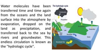
  • 1. Water molecules have been transferred time and time again from the oceans and the land surface into the atmosphere by evaporation, dropped on the land as precipitation, and transferred back to the sea by rivers and groundwater. This endless circulation is known as the "hydrologic cycle".
  • 2. 0- Evaporation from Ocean 1- Raindrop evaporation 2- Interception 3- Transpiration 4- Evaporation from land 5- Evaporation from water bodies 6- Surface runoff 7- Infiltration 8- Ground water Deep percolation
  • 3. Precipitation: The term precipitation denotes all forms of water that reached the earth’s surface from atmosphere. Rain, drizzle, hail and snow are examples of precipitation. Causes of precipitation: It is necessary that the moist air masses to cool in order to condense. This is generally accomplished by adiabatic cooling of moist air through a process of being lifted to higher altitudes. Types of precipitation:  Frontal precipitation: This is the precipitation that is caused by the expansion of air on ascent along or near a frontal surface.
  • 4. Convective precipitation: Precipitation caused by the upward movement of air which is warmer than its surroundings. This precipitation is generally showery nature with rapid changes of intensities. Orographic precipitation: Precipitation caused by the air masses which strike the mountain barriers and rise up, causing condensation and precipitation. The greatest amount of precipitation will fall on the windward side of the barrier and little amount of precipitation will fall on leave ward side.
  • 5. Forms of precipitation: • Rain- It is used to describe precipitation in the form of water drops of sizes in the range of 0.5mm to 6mm. • Snow- It consists of ice crystals which usually combine to form flakes. • Drizzle- It is fine sprinkle of numerous water droplets of size less than 0.5mm and intensity less than 1.5mm/hr.
  • 6. • Glaze- When rain or drizzle comes in contact with cold ground at around 0° C, the water drop freezes to form an ice coating called as Glaze. • Sleet- It is frozen raindrops of transparent grains which forms when rain falls through air at subfreezing temperature. • Hail- It is a showery precipitation in the term of ice of size more than 8mm. • Dew- It forms directly by conensastion on the ground mainly during the night when the surface has been cooled by outgoing radiation.
  • 7.
  • 8. 2- Weighting Bucket rain gauge.
  • 9. Measurement of Precipitation: (a)- Recording Type : 1- Tipping Bucket rain gauge.
  • 10. 3- Siphon Rain gauge.
  • 12. Analysis and Interpretation of precipitation Data: 1- Intensity: It is a measure of quantity of rain falling in a given time in a specific area. It is usually expressed in mm/hr. 2- Duration: It is a period of time during which Rainfall occurs. 3- Frequency: This refers to the probability that given depth of Rainfall which will fall in a given time. 4- Areal extent: This concerns the area over which a point Rainfall can be held to apply.
  • 13. 5- Rainfall mass curve: It is plot of cumulative Rainfall against Time. Slope of the tangent drawn to the rainfall mass curve at any time will gives intensity of rainfall.
  • 14. 6- Rainfall Hyetograph: It is a plot between Rainfall Intensity Vs Time. The area under Hyetograph represents the total precipitation received in that period.
  • 15. Raingauge network: Adequacy of Raingauge stations:
  • 16.
  • 17.
  • 18.
  • 20.
  • 21. Interception: When it rains over a catchment, not all the precipitation falls directly onto the ground. Before it reaches the ground, a part of it may be caught by the vegetation and subsequently evaporated. The volume of, water so caught is called Interception. DEPRESSION STORAGE: When the precipitation of a storm reaches the ground, it must first fill up all depressions before it can flow over the surface. The volume of water tripped in these depressions is called depression storage. This amount is eventually lost to runoff through processes of infiltration and evaporation and thus form a part of the initial loss. Depression storage depends on a vast number of factors the chief of which are:
  • 22. • The type of soil • The condition of the surface reflecting the amount and nature of depression • The slope of the catchment • The antecedent precipitation, as a measure of the soil moisture. INFILTRATION: It is the flow of water into the ground through the soil surface. The distribution of soil moisture within the soil profile during the infiltration process is illustrated in Fig. When water is applied at the surface of a soil, four moisture zones in the soil, as indicated in Fig. can be identified.
  • 23. Zone 1: At the top a thin layer of saturated zone is created. Zone 2: Beneath zone 1, there is a transition zone. Zone 3: Next lower zone is the transmission zone where the downward motion of the moisture takes place. The moisture content in this zone is above field capacity but below saturation. Zone 4: The last zone is the wetting zone. The soil moisture in this zone will be at or near field capacity and the moisture content decreases with the depth. The boundary of the wetting zone is the wetting front where a sharp discontinuity exists between the newly wet soil and original moisture content of the soil. Depending upon the amount of infiltration and physical properties of the soil, the wetting front can extend fron1 a few centimetres to metres.
  • 24.
  • 25. INFILTRATION CAPACITY: The maximum rate at which a given soil at a given time can absorb water is defined as the infiltration capacity. It is designated as fp and is expressed in units of cm/h. The actual rate of infiltration f can be expressed as: f = fp when i > fp or i = fp , and f = i when i <j Where, i = intensity of rainfall. The infiltration capacity of a soil is high at the beginning of a storm and has an exponentially decay as the time elapses. The infiltration capacity of an area is dependent on a large number of factors:
  • 26.  Characteristics of the soil  Condition of the soil surface  Current moisture content  Vegetative cover  Soil temperature CHARACTERISTICS OF SOIL : The type of soil, viz. sand, silt or clay, its texture, structure, permeability and under drainage are the important characteristics under this category. A loose permeable sandy soil will have a larger infiltration capacity than a tight clayey soil. A soil with good underdrainage, i.e. the facility to transmit the infiltered water downward to a groundwater storage would obviously have a higher infiltration capacity. When the soils occur in layers, the transmission capacity of the layers determines the overall infiltration rate.
  • 27. Infiltration indices: The two commonly used infiltration indices are the following - • φ – index: This is defined as the rate of infiltration above which the rainfall volume equals runoff volume. The method to determine the φ - index would usually involve some trial. Since the infiltration capacity decreases with a prolonged storm, the use of an average loss rate in the form of φ - index is best suited for design storms occurring on wet soils in which case the loss rate reaches a final constant rate prior to or early in the storm.
  • 28. • W – index : This is the average infiltration rate during the time when the rainfall intensity exceeds the infiltration rate. It may be mathematically calculated by dividing the total infiltration (expressed as a depth of water) divided by the time during which the rainfall intensity exceeds the infiltration rate. Total infiltration = Total precipitation – Surface runoff – Effective storm retention The W – index can be derived from the observed rainfall and runoff data. It differs from the φ - index in that it excludes surface storage and retention.
  • 29. Evapotranspiration: It consists of evaporation from soil and water bodies and loss of water from plant leaves, which is called transpiration. It is a major component of the hydrologic cycle and its information is needed to design irrigation projects and for managing water quality and other environmental concerns. In urban development, evapotranspiration calculations are used to determine safe yields from aquifers and to plan for flood control. For a given set of atmospheric conditions, evapotranspiration depends on the availability of water.
  • 30. If sufficient moisture is always available to completely meet the needs of vegetation fully covering the area, the resulting evapotranspiration is called potential evapotranspiration (PET). The real evapotranspiration occurring in a specific situation is called actual evapotranspiration (AET).
  • 31. The term consumptive use is also sometimes used to denote the loss of water molecules to atmosphere by evapotranspiration. The term consumptive use is also sometimes used to denote the loss of water molecules to atmosphere by evapotranspiration. For a given set of atmospheric conditions, evapotranspiration depends on the availability of water.
  • 32. If sufficient moisture is always available to completely meet the needs of vegetation fully covering the area, the resulting evapotranspiration is called potential evapotranspiration (PET). The real evapotranspiration occurring in a specific situation is called actual evapotranspiration (AET).
  • 33. CATCHMENT AREA: The area of land draining into a stream or a water course at a given location is known as catchment area. lt is also called as drainage area or drainage basin. In USA, it is known as watershed. A catchment area is separated from its neighbouring areas by a ridge called divide in USA and Watershed in UK.
  • 34. The areal extent of the catchment is obtained by tracing the ridge on a topographic map to delineate the catchment and measuring the area by a Planimeter.
  • 35.
  • 36.
  • 37.
  • 38.
  • 39.
  • 40. RUNOFF: Runoff means the draining or flowing off of precipitation from a catchment area through a surface channel. It thus represents the output from the catchment in a given unit of time. For a given precipitation, the evapotranspiration, initial loss, infiltration and depression storage requirements will have to be first satisfied before the commencement of runoff. When these are satisfied, the excess precipitation moves over the land surfaces to reach smaller channels. This portion of the runoff is called Overland flow and involves building up of a storage over the surface and draining off of the same. Flows from several small channels join bigger channels and flows from these in turn combine to form a larger stream, and so on, till the flow, reaches the catchment outlet. The flow in this mode, where it travels all the time over the surface as overland flow and through the channels as open-channel flow and reaches the catchment outlet is called surface runoff.
  • 41. A part of the precipitation that infilters moves laterally through upper crusts of the soil and returns to the surface at some location away from the point of entry into the soil. This component of runoff is known as interflow. Based on the time delay between the precipitation and the runoff, the runoff is classified into two categories: as 1. Direct runoff and 2. Base flow