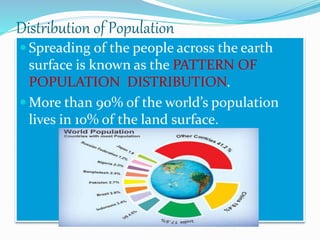
Human beings are considered the most important resource for a country's development. A country's human resources are not evenly distributed and differ based on factors like education, sex, age, and characteristics. A population pyramid can show the composition of a country's population, including the percentage of males and females in different age groups. It reveals features like birth and death rates, number of dependents, and size of the labor force. Countries with high birth and death rates have broad bases and narrow tops in their pyramids, while countries with declining death rates have broader bases, representing more surviving children.
Class 8 Chapter 3 minerals and power resources geography slide showalwayshelp
The document discusses minerals, including their definition, formation, distribution, types, and extraction methods. It provides details on key points:
- Minerals are naturally occurring substances with definite chemical compositions that form through geological processes without human interference.
- Metallic minerals contain metals and include ferrous minerals like iron ore and non-ferrous minerals like copper. Non-metallic minerals do not contain metals like limestone.
- Major extraction methods are mining, drilling, and quarrying. Mining removes minerals from underground using open-cast or shaft mining. Drilling extracts oil and gas while quarrying digs out near-surface minerals.
- Asia, Europe, North and South America, Africa,
The document discusses human resources and population distribution. It notes that people are a nation's greatest resource and turn natural resources into usable resources. It then discusses how human resources, like other resources, are unevenly distributed worldwide and vary in factors like education, age, and sex. More than 90% of the world's population lives in 10% of the land area. The distribution is uneven with some areas like South and Southeast Asia being very crowded and others like deserts and high altitude areas being sparsely populated. Climate, resources, and economic opportunities also influence population distribution and change over time.
The document discusses the role of the judiciary in India. It notes that India has a rule of law and an independent judicial system to enforce the law. The judiciary plays a crucial role in India's democracy by resolving disputes, interpreting the constitution, protecting fundamental rights, and acting as a check on the other branches of government. However, access to justice remains difficult for many poor citizens due to the complex legal system and long wait times for cases to be resolved.
The document discusses human resources as the ultimate resource for a nation. It provides information on population distribution patterns around the world, noting that over 90% of the world's population lives in just 10% of the land area. It also discusses factors that influence population density like geography, climate, resources and economic opportunities. Population pyramids are presented as a way to understand the composition of a population in terms of age and sex. Countries with high birth and death rates have broad bases that taper at the top, while countries with low birth rates have narrow bases.
Birsa Munda led a movement against the British colonial government in the late 1800s in present-day Jharkhand and Odisha. The document discusses how tribal groups in this region traditionally lived by practices like jhum cultivation and herding, but were negatively impacted by British policies aimed at sedentarization and control of forest resources. Tribal chiefs lost power and people faced exploitation. Birsa Munda's movement sought to recover tribal peoples' independence and way of life, establishing a "golden age." Though Birsa died in 1900, his movement drew attention to injustice and introduced some legal protections for tribal land rights.
The document summarizes the causes and key events of the Indian Rebellion of 1857. It describes how sepoys in the East India Company's army first mutinied in Meerut in May 1857 over new equipment and policies that violated religious beliefs. The mutiny then spread to other regions as many civilians and rulers joined the rebellion. Major cities like Delhi, Kanpur, and Lucknow became rebel strongholds. It took the British until 1859 to suppress the widespread rebellion across northern India.
The document summarizes the history of textile and steel industries in India under British rule. It notes that the English East India Company initially came to trade Indian goods but later occupied India. British industrialization had a close connection to the colonization of India. Indian textiles, especially cotton, were renowned globally but British policies like the Calico Act restricted Indian textile exports. The Industrial Revolution in Britain decimated the Indian textile industry. The establishment of mills in India in the late 19th century marked a revival. Similarly, Wootz steel from India was renowned for swords but British policies led to the abandonment of iron smelting furnaces. The discovery of iron ore in Chhattisgarh and establishment of T
The document discusses the Earth's atmosphere, including its composition and structure. It notes that the atmosphere is composed primarily of nitrogen and oxygen, and also contains trace amounts of other gases like carbon dioxide. The atmosphere is divided into five layers - the troposphere, stratosphere, mesosphere, thermosphere, and exosphere - with the troposphere being the lowest layer where weather occurs and we breathe. Each higher layer extends further from the Earth's surface, with the thermosphere aiding radio transmission and the exosphere being where light gases escape into space.
The document provides an introduction to the solar system and celestial bodies. It defines celestial bodies as objects in the night sky that emit their own heat and light, including stars and planets. It explains that the Sun, Moon, and planets, along with asteroids and meteoroids, make up the solar system with the Sun at the center. It provides some key facts about planets such as Mercury being the closest planet to the Sun and Venus being similar in size and shape to Earth.
Laws apply equally to all citizens regardless of attributes and are created through a multi-step legislative process. When issues arise, citizens can raise awareness through media to propose new laws. If approved by committees and parliamentary votes, a law is sent to the president for approval and introduction to society. Some laws may be unpopular or controversial if seen as unfair or harmful by many, and public criticism can force reconsideration of such laws. As representatives of citizens, it is important for people in a democracy like India to be aware of rights and provide feedback to ensure proper parliamentary functioning.
G 7 his ch-2 ppt new kings and kingdoms full chapter Preeti Pachauri
The Chola dynasty emerged as a powerful kingdom in South India between the 7th and 12th centuries:
[1] The Cholas originated from the town of Uraiyur but the king Vijayalaya captured the fertile Kaveri delta in the 9th century and established a new capital at Thanjavur.
[2] The Chola kingdom reached its peak under kings Rajaraja I and his son Rajendra I in the 10th-11th centuries, with the empire extending over South India and parts of Sri Lanka and Southeast Asia.
[3] The Cholas built magnificent temples like Brihadeeswarar Temple at Thanjavur and Gangaikond
This document discusses various topics related to human resources and population distribution. It defines human resources as the ultimate resource and discusses how population is unevenly distributed worldwide based on geographical, social, cultural and economic factors. Some key points are: populations are concentrated in Asia and Africa, birth rates exceeding death rates have led to rapid global population growth, and population pyramids provide information on a country's population composition and dependency levels.
The making of the national movement: 1870s - 1947 | Ls-11 | History | Class - 8 SugeethJayarajSA
Well, let's take a look at the past of India. India is a land filled with great wonders. Let's look at a class 8 History ppt filled with lots of info put in a very attractive manner about the making of the national movement.
How, When And Where - Class 8 - History - (Social Studies)AnjaliKaur3
This PPT explains history chapter 1 from NCERT book in a very different manner. It will be useful for students and for teachers. It contains more information apart from books and hopefully students will find it interesting as they can relate this topic by going through different examples.
The document summarizes key events of the 1857 rebellion in India against the British East India Company. It describes how the company gradually eroded the power of local rulers like the Nawabs. This caused resentment among rulers and sepoys. In 1857, sepoys in Meerut mutinied after being issued new gun cartridges greased with animal fat. They marched to Delhi and joined the Mughal emperor Bahadur Shah Zafar. The rebellion then spread across many regions led by figures like Rani Lakshmibai of Jhansi and Nana Saheb. Though the British regained control after two years of fighting, the company's power was transferred to the British crown, and policies changed to reduce
Prepared By
IT CLUB, Sainik School Amaravathinagar
Post: Amaravathinagar
Dist: Tiruppur, Tamilnadu
Club I/c
Praveen M Jigajinni
DCSc & Engg,PGDCA,ADCA,MCA,MSc(IT),MTech(IT), M.Phil (Comp Sci)
For Any Queries Please feel free to contact:
Email Id : praveenkumarjigajinni@gmail.com
Cell No: 9431453730
The document provides information about the Earth and its position in the solar system. It discusses the Earth's rotation and revolution, and how this affects seasons. It also describes the globe and important lines of latitude and longitude that are used to locate places. Key features of the Earth such as its shape, layers, continents and oceans are summarized. Different types of maps and their uses are also outlined.
it is a very creative slide .it help to make the chapter easy to be understand it is very difficult chapter but by this ppt you can easily understand the chapter
Land, soil, water, natural vegetation, and wildlife are important natural resources. Land covers 29% of the Earth's surface and is unevenly distributed worldwide due to differences in characteristics and climate. Soil is formed through weathering and influenced by parent rock and climate factors. It is degraded through processes like erosion, but conservation methods like contour farming and shelter belts can help protect it. Water is essential for life but most is saline or locked in ice sheets; only 1% is accessible as freshwater in rivers, lakes, and groundwater. Natural vegetation and wildlife exist within ecosystems and depend on each other for survival.
Grade - 8 Geography Chapter - 4. Agriculture Navya Rai
Grade - 8 Geography Chapter - 4. Agriculture
Agriculture describes the practice of growing crops or raising animals.
The transformation from a plant to a finished product involves three types of economic activities- They are Primary, Secondary and Tertiary
The document appears to be a series of emails from "sonawane11jan@rediffmail.com" on June 8, 2015 with no other notable information in the body of the emails. It consists of over 60 brief emails sent consecutively from the same sender to an unknown recipient.
This document summarizes where early people lived in India, including along river banks like the Narmada, Sulaiman Hills, and Ganges. It notes that some of the earliest cities flourished 4700 years ago along the Indus River. Powerful kingdoms were set up in areas like Magadha along the Ganges. The document lists reasons for movement of people including livelihood, natural disasters, trade, and religion. It briefly discusses the origins of the names India and Bharat. Sources for learning about the past are identified as manuscripts, inscriptions, and archaeology.
William Jones came to India in 1783 and learned several Indian languages including Sanskrit. He helped establish the Asiatic Society of Bengal to promote the study of Asian languages, literature, and culture. The Society published the journal Asiatick Researches. Jones and others recognized connections between Sanskrit and European languages. However, British officials like Macaulay later criticized teaching Indian languages and cultures, arguing it had no practical use. Macaulay's views influenced the 1835 English Education Act which made English the medium of instruction in higher education.
The document discusses two major river basins - the Amazon Basin and the Ganga-Brahmaputra Basin. The Amazon Basin covers parts of South America and is home to the dense Amazon rainforest, which contains a diverse array of flora and fauna. The Ganga-Brahmaputra Basin lies in the Indian subcontinent and is drained by the Ganga and Brahmaputra rivers and their tributaries. It contains plains, Himalayan foothills, and the Sundarbans delta and experiences a monsoon climate. Major cities in the basin include Kolkata, Patna, and Varanasi.
The document discusses human resources and population distribution, density, and composition. It notes that over 90% of the world's population lives in 30% of the land area, with dense populations in South and Southeast Asia, Europe, and Northeastern North America. Population distribution is affected by geographical features like climate and resources. The average global population density is 51 people per square km, with South-Central Asia having the highest density. Population composition examines factors like age, sex, occupation, and can be viewed through population pyramids.
More than 90% of the world's population lives in just 30% of the land area, with 60% residing in 10 countries alone. Population density refers to the number of people per unit area and is affected by geographical factors like climate, soil fertility, availability of water, and presence of minerals. Social, cultural, and economic considerations also influence population distribution patterns. Population change is driven by birth and death rates as well as migration patterns. Composition of a population can be understood by analyzing factors such as age, sex, education level, occupation, income, and health status using tools like population pyramids.
People are considered a nation's most important resource as it is humans who transform natural resources into useful goods through intelligence and labor. The distribution of human population across the world is uneven, with over 90% living in just 10% of the land, concentrated most densely in parts of Asia, Europe, and Northeastern North America. Key factors that influence population patterns include the environment, resources, infrastructure, culture, religion, and economic opportunities in different areas.
Human beings are the ultimate resource of a nation as they transform natural resources into useful goods through intelligence and labor. The distribution of human population across the globe is uneven, with over 90% living in just 10% of the world's land area, concentrated most densely in South and Southeast Asia, Europe, and Northeastern North America. Almost three quarters of the global population resides in just two continents - Asia and Africa. Factors like climate, resources, infrastructure, culture and religion all impact population distribution patterns around the world.
This is an ppt for the topic human resources for class VIII students, it consists pictures and graphs for better understanding and for their knowledge that human are the most crucial for resources. Students will came to know about how human resources are essential for a country for its development. It will provide knowledge about the importance of human resources, Human resources plays a key role in developing, reinforcing, and changing the culture of an organization.
The document discusses factors that affect the distribution of population across the world's land surface. It notes that more than 90% of the world's population lives in just 30% of the land area, and that distribution is extremely uneven. Some key factors that influence where people live include fertile soils and availability of fresh water, which lead to densely populated river valleys, as well as preferences for temperate plains over extreme climates or mountainous regions. Industrial areas and places of religious significance also attract larger populations. Population change is influenced by birth rates, death rates, and migration patterns.
The world population distribution, density and growthAshaJegadeesan
The document discusses key topics related to world population including:
1. The current world population is 7.8 billion as of 2020 and is unevenly distributed across the world.
2. Population density varies based on factors like climate, resources, and level of development. densely populated areas have over 200 people per square km while sparsely populated areas have under 1 person per square km.
3. Population growth is influenced by birth rates, death rates, and migration patterns. Most countries have experienced a demographic transition from high birth/death rates to low birth/death rates as development increased.
This document discusses human resource distribution and population trends around the world. It notes that 90% of the world's population lives in just 10% of the land area, with certain regions like South and Southeast Asia, Europe and Northeastern North America being more densely populated. Population density is highest in South Central Asia at an average of 45 people per square km globally. Factors that influence population distribution include geography, climate, resources, as well as social and economic conditions. The document also examines population change through birth and death rates and provides population pyramid examples for India and China.
This document discusses topics related to population geography, including population growth rates, distribution, and density. It provides definitions and factors that influence high and low population growth rates. Countries with low economic development often have high growth rates due to high birth rates and low death rates. Developed countries typically have low growth rates because of low birth and death rates, attributed to factors like access to family planning, health care, and nutrition. The document also examines actions taken to control high or low growth rates and the consequences of each.
The document provides information about population geography in India. It defines key population terms like population, population distribution, and processes of population change through birth, death, and migration. It notes that India has the second largest population in the world at over 1.2 billion people as of 2011. The document also discusses India's population size and distribution across states, population growth rates, age and sex composition, literacy rates, and occupational structure. It provides context on India's national population policy and its aims to encourage delayed marriage and childbearing as well as improve access to education and healthcare.
World population is unevenly distributed, with 90% living in just 10% of the Earth's land area. The main geographic factors that influence population distribution are the availability of water, fertile land, a comfortable climate, and mineral resources. Areas with more economic opportunities like cities, industrial belts, and places with religious significance tend to have denser populations. Population change is measured by birth rate, death rate, and migration. While it took millions of years for the global population to reach 1 billion, it only took 12 years to grow from 5 to 6 billion due to declining mortality rates.
This document discusses key concepts related to population studies including:
1. It defines population and demography, and describes sources used to obtain population information like censuses and municipal registers.
2. It explains factors that influence population distribution including physical conditions, human conditions, and population density which is used to measure distribution.
3. It describes natural population change through births and deaths, and how birth rates and death rates are calculated and vary between developed and developing countries. Natural increase is the difference between births and deaths.
4. It discusses regular and migratory population movement, with migratory movement including emigration and immigration between places.
Population studies involve acquiring knowledge about factors influencing population and its distribution. Population refers to the number of people in a given area. Population geography studies the distribution of human populations in a location. Population dynamics examines changes in population numbers due to factors like fertility, mortality, and migration. Population is both impacted by development processes and environmental factors, and influences development as a resource that transforms the environment. Key population terms include aging population, life expectancy, child and infant mortality rates, fertility rates, and dependency ratios. Physical factors like climate and terrain, and human factors like economic opportunities and transportation influence population distribution and density.
This document discusses human population distribution and key issues related to demographics. It notes that three quarters of the world's population lives in only 5% of the land area, with two thirds living near oceans or rivers. Major population concentrations exist in East Asia including China, South Asia including India, Europe, and North America's northeast corridor. The document outlines the demographic transition from high birth and death rates to low rates, fueled by improved agriculture and medicine. It analyzes population growth trends, policies, and impacts of aging and disease using population pyramids.
Population density is affected by factors like latitude, altitude, terrain, and climate. Areas at higher altitudes and latitudes tend to be less populated than lowlands, as high altitudes provide cooler temperatures suitable for habitation while low latitude areas are hot. Mountains have seen population growth with cities like La Paz developing at high altitudes. Plains see higher population densities compared to mountains and cold/hot deserts. River valleys and deltas are also favorable for agriculture and development.
Measures to control population growth include increasing access to education and healthcare, promoting family planning and use of contraceptives, raising the status of women, increasing the marriageable age, and improving living standards and opportunities for employment. The human development index
Population density and distribution are influenced by various environmental factors. Mountains provide more suitable living conditions than low-lying plains due to cooler temperatures at higher altitudes. As a result, many large cities have developed in mountainous areas.
Solutions for controlling population growth include increasing access to education, family planning services, and raising the status of women. Providing employment opportunities, especially for women, and improving standards of living can encourage smaller family sizes. Legislative actions around marriage age, child labor, and reproductive health can also help slow rapid population growth.
The Human Development Index is a statistic used to rank countries based on indicators of life expectancy, education, and income levels. Countries score higher on human development when citizens can expect
This document announces the winners of the 2024 Youth Poster Contest organized by MATFORCE. It lists the grand prize and age category winners for grades K-6, 7-12, and individual age groups from 5 years old to 18 years old.
Boudoir photography, a genre that captures intimate and sensual images of individuals, has experienced significant transformation over the years, particularly in New York City (NYC). Known for its diversity and vibrant arts scene, NYC has been a hub for the evolution of various art forms, including boudoir photography. This article delves into the historical background, cultural significance, technological advancements, and the contemporary landscape of boudoir photography in NYC.
❼❷⓿❺❻❷❽❷❼❽ Dpboss Kalyan Satta Matka Guessing Matka Result Main Bazar chart Final Matka Satta Matta Matka 143 Kalyan Chart Satta fix Jodi Kalyan Final ank Matka Boss Satta 143 Matka 420 Golden Matka Final Satta Kalyan Penal Chart Dpboss 143 Guessing Kalyan Night Chart
This tutorial offers a step-by-step guide on how to effectively use Pinterest. It covers the basics such as account creation and navigation, as well as advanced techniques including creating eye-catching pins and optimizing your profile. The tutorial also explores collaboration and networking on the platform. With visual illustrations and clear instructions, this tutorial will equip you with the skills to navigate Pinterest confidently and achieve your goals.
KALYAN MATKA | MATKA RESULT | KALYAN MATKA TIPS | SATTA MATKA | MATKA.COM | MATKA PANA JODI TODAY | BATTA SATKA | MATKA PATTI JODI NUMBER | MATKA RESULTS | MATKA CHART | MATKA JODI | SATTA COM | FULL RATE GAME | MATKA GAME | MATKA WAPKA | ALL MATKA RESULT LIVE ONLINE | MATKA RESULT | KALYAN MATKA RESULT | DPBOSS MATKA 143 | MAIN MATKA
❼❷⓿❺❻❷❽❷❼❽ Dpboss Matka ! Fix Satta Matka ! Matka Result ! Matka Guessing ! Final Matka ! Matka Result ! Dpboss Matka ! Matka Guessing ! Satta Matta Matka 143 ! Kalyan Matka ! Satta Matka Fast Result ! Kalyan Matka Guessing ! Dpboss Matka Guessing ! Satta 143 ! Kalyan Chart ! Kalyan final ! Satta guessing ! Matka tips ! Matka 143 ! India Matka ! Matka 420 ! matka Mumbai ! Satta chart ! Indian Satta ! Satta King ! Satta 143 ! Satta batta ! Satta मटका ! Satta chart ! Matka 143 ! Matka Satta ! India Matka ! Indian Satta Matka ! Final ank
2. INTRODUCTION
Human resource is the ultimate resource.
People with their demands and abilities
turns into resources.
Healthy, educated and motivated people
develop the resources.
It differ on educational levels, age and sex.
In india HRD ministry to improve skills.
3. Distribution of Population
Spreading of the people across the earth
surface is known as the PATTERN OF
POPULATION DISTRIBUTION.
More than 90% of the world’s population
lives in 10% of the land surface.
4. CROUDED AREAS
1. SOUTH ASIA
2. SOUTH EAST ASIA
3. EUROPE
4. NORTH EASTERN NORTH AMERICA
FEW PEOPLE LIVE IN
1. HIGH LATITUDE AREAS
2. TROPICAL DESERTS
3. HIGH MOUNTAINS
4. EQUATORIAL FOREST
5. More people live north of the equator than south.
Three- quarters of world live in Asia and Africa.
60% of the world’s population lives in just 10
countries.
Out of every 100 people in the world:
61 people live in Asia,
12 people live in Europe,
13 people live in Africa,
8 people live in central and South America,
5 people live in northern America and
1 people live in Oceania (Australia, New Zealand
and Pacific Islands).
6. Density of population
The number of people living in a unit area is called
density of population.
It is usually expressed as number of persons per
square km.
The average population density of the world is 51
persons per square km.
South Central Asia have the highest population
density; followed by East and South East Asia.
The population density in India is 382 persons per
square km.
7. Factors affecting the
distribution of population
Topography: A larger number of people live in the
plains than in the mountains or plateaus. Plains
are suitable for farming, manufacturing and most
of the other activities. The Ganges plains are the
most densely populated area of the world.
Climate: People prefer to live in moderate climates
and avoid extreme climates. Hence, less number of
people lives in the Sahara Desert and in the polar
regions of Russia, Canada.
8. Soil: Fertile plains of the Ganges and Brahmaputra
(India), Hwang-he, Chang Jiang (China) and the
Nile (Egypt) are the areas with a high population
density.
Water: Water is essential for survival of people and
hence, more people live in the river valleys than in
the deserts.
Minerals: Areas with mineral deposits attract
people because of potential of economic
development.
9. Social, Cultural and Economic Factors
Social: Areas with better housing, education and
health facilities are more densely populated. Pune,
Bangalore and Delhi are the cities of better facilities.
Cultural: Places with religion or cultural significance
always attract people. Varanasi, Jerusalem and Vatican
City are densely populated.
Economic: Industrial areas give lot of opportunities to
people. Mumbai’s population grew because of this
reason. In recent years, areas around Delhi have
attracted a large number of migrants from across the
country; because of industrial development.
10. Population change
It is the change in the number of people during a
specific time.
It occur by the changes in number of deaths and
births.
Until the 1800s, the world’s population grew at a slow
and steady. Many died by the improper health facility.
In 1804 popualtion reached to one billion.
In 1959 it reached to 3 billion.
In 1999 reached to 6 billion.
Life expectancy: The number of years that an average
person is expected to live is called life expectancy.
11. Birth Rate: The number of live births per 1,000
people is called birth rate.
Death Rate: The number of deaths per 1,000
people is called death rate.
When the death rate is more than the birth rate, it
will lead to de-growth in population.
When the birth rate is equal to death rate, there
will be no growth in population.
When the birth rate is higher than death rate, it
will lead to growth in population.
The difference between birth rate and death rate is
called natural growth rate of population.
12. MIGRATION
MIGRATION: When people move from one place
to another in search of livelihood.
EMIGRATION: When people move outside their
country, it is called OUT MIGRATION.
IMMIGRATION: When people come from another
country, it is called IN MIGRATION.
The population of the USA and Australia has
increased because of immigration. On the other
hand, the population of Sudan has decreased
because of emigration. People from less developed
countries usually migrate to the developed
countries in search of better employment
opportunities.
14. Population Composition
The population composition of a country tells about
age profile, sex, literacy level, health condition,
occupation and income level.
The structure of the population is called population
composition.
It is looked by the population pyramid or age-sex
pyramid.
15. Population pyramid
A population pyramid is a graphical
representation of population composition.
In a population pyramid, the total
population is divided into various age
groups, e.g. 5 to 9 years, 10 to 14 years, etc.
For each age group, the percentage of the
total population is subdivided into males
and females.
16. Population pyramid of India
The population pyramid of India shows a wider base
but the middle portion of the pyramid is in healthy
shape. The top is narrow.
This shows that there is sizeable proportion of
people in economically productive age group. This is
a good sign for the economy of India as the number
of dependents is not too much.