Downloaded 49 times
![Departamento de Geografía e Historia
ACTIVITIES: THE LAYERS OF THE EARTH.
1. Colour each of the layers of the Earth. Then fill in the legend of
the right. Finally, answer the questions.
a) What is the thicker layer?
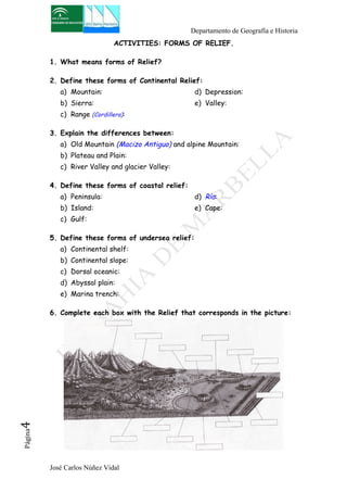
b) What is the main component of the core?
c) Do the rocks beneath seas and oceans form part of the cortex?
d) What is the main characteristic that identifies each of theses
layers? Define Each.
2. Complete, in your notebook, the table Below:
[Look for the information in the textbook]
Depth Material ¿Is it solid or liquid? Thickness
Cortex
Mantex
Core
3. Define the following concepts:
a) Pangea:
b) Plate Tectonics:
c) Oceanic crust:
d) Continental cortex:
4. Complete the map below.
[You can help yourself with the map on the textbook]
José Carlos Núñez Vidal Página2](https://image.slidesharecdn.com/homeworks-140902061220-phpapp02/85/Homeworks-2-The-Relief-2-320.jpg)


![Departamento de Geografía e Historia
José Carlos Núñez Vidal Página9
REVIEW ACTIVITIES.
1. Complete the map with the two thinks I ask you [You have help on
the map in the textbook]
a) Colour each kind of Relief according to legend.
b) Put in each circle the number of relief that corresponds.
2. Using the dates below, built a graphic about the surface of the
continents and the total surface of the emerged lands.
Asia: 44. 513.313 Km2
América: 42.035.238 Km2
África: 30.180.808 Km2
Antártica: 13.176.727 Km2
Europa: 10.522.140 Km2
Oceanía: 8. 945.728 Km2
3. Compare it with the graphic to the oceans and say if it is true that:
a) Oceans and seas occupy two-thirds of the Earth.
b) The Pacific Ocean is greater than all the landmasses together.](https://image.slidesharecdn.com/homeworks-140902061220-phpapp02/85/Homeworks-2-The-Relief-9-320.jpg)

This document provides a study guide for a geography exam on earth's layers, tectonic plates, types of landforms, and world reliefs. It lists key concepts students need to know, such as the characteristics of the earth's layers and definitions of landforms. It also provides review activities like labeling maps of continental reliefs, oceans, and drawing graphics to compare land and ocean sizes. The goal is to test students' understanding of earth science topics for the exam.


