Groundwater methane in relation to oil and gas development and shallow coal seams in the Denver-Julesburg Basin of Colorado
•
1 like•601 views

A research paper published in the Proceedings of the National Academy of Sciences. The paper evaluated the level of methane in groundwater in Colorado going back 25 years. It finds the rate of groundwater methane did not change after the introduction of horizontal drilling combined with high-volume hydraulic fracturing in 2010. That is, fracking does not increase methane migration.
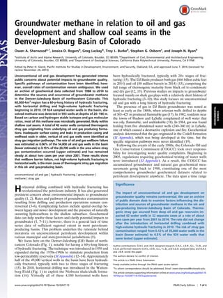
![over which oil and gas wellbore construction evolved from
vertical wells with uncemented sections to horizontal wells with
fully cased and cemented vertical sections (20). We obtained
data from the COGCC in October 2014, and after rigorous
data screening and quality control protocols (SI Appendix), we
examined the distribution and origins of groundwater methane in
relation to oil and gas development in the DJ Basin.
Results and Discussion
Dissolved methane was detected in 593 water wells, representing
a majority (64%) of the 924 water wells for which analysis for
methane was conducted. The COGCC reporting threshold of
1 mg/L methane was exceeded in 261 wells. The hazard threshold
of 10 mg/L was exceeded in 122 wells, and the hazard mitigation
level of 28 mg/L was exceeded in 5 wells (SI Appendix). Long-
term repeatability in dissolved methane measurements was
assessed from a subset of 92 water wells that underwent follow-
up sampling over a period of up to 20 y. Sample pairwise dif-
ferences varied by 67% (1 SD, n = 136; SI Appendix), which
highlights well-known problems in repeatability of dissolved
methane measurements due to hydrological variability and
sampling and analytical methods (11, 21). Nevertheless, overall
spatial and temporal patterns of dissolved methane provide
valuable insights to origins and associated hazards of ground-
water methane in the DJ Basin (Fig. 1).
Genetic origins of groundwater methane were assessed from
stable carbon isotopes of methane (δ13
CC1) and gas molecular
ratios [C1/(C2 + C3)] in 211 of the water wells (22) (Fig. 2 and SI
Appendix). Dissolved methane concentrations were >1 mg/L in
all but four of the water wells. Of these 211 wells, 169 had
methane with δ13
CC1 < −60‰ and C1/(C2 + C3) > 100, char-
acteristic of microbial methane. Stable hydrogen isotope ratios
(δ2
HC1) further showed that the microbial methane is in-
termediate between the CO2 reduction and acetate fermentation
methanogenic pathways (SI Appendix). Another 29 water wells
contained methane with δ13
CC1 > −55‰ and C1/(C2 + C3) < 50,
characteristic of thermogenic methane. A final 13 wells had
isotopic and molecular values representing mixed microbial-
thermogenic methane [δ13
CC1 < −55‰ and C1/(C2 + C3) < 100]
Denver
Wyoming Nebraska
Kansas
Colorado
Denver
Dissolved CH4 (mg/l):
not detected
>0 - 1
>1 - 10
>10 - 28
>28
0 25 50 75 10012.5
Kilometers
State
County
DJ Basin
Wattenberg Field
Coal Fields
Coal-Bearing Areas
Wrench Faults
Dawson
Denver
Arapahoe
Laramie
Laramie-Fox Hills
Dakota-Cheyenne
High Plains
Aquifer Formations:
Thermogenic CH4
!
Oil/Gas Wells
Boulder-Weld
Coal Field
Scranton
Coal Field
Coal Samples
B
A
Fig. 1. Study area in the DJ Basin of Northeastern Colorado. (A) Overview
map showing distribution of dissolved methane and thermogenic gas oc-
currences in 924 groundwater wells in relation to aquifers and oil and gas
wells. (B) Closeup of Wattenberg field, also showing the distribution of coal-
bearing deposits and coal mining fields (23), and northeast-trending wrench
faults (12). Location of coal samples discussed in text is shown in both panels.
Aquifers of the Denver Basin aquifer system (Dawson through Laramie-Fox
Hills) are listed from youngest (Top) to oldest; Dakota-Cheyenne and High
Plains represent separate aquifer systems (44). Fig. 2. Genetic characterization plot (22) of C1/(C2 + C3) vs. δ13
CC1 for
groundwater aquifers compared with natural gases from producing for-
mations in Wattenberg field. Repeat samples from water wells are included.
Groundwaters fall within microbial and thermogenic domains and along a
mixing line (bold curve) calculated for thermogenic [δ13
CC1 = −46‰; C1/(C2 +
C3) = 5] and apparent Laramie-Fox Hill (LFH) microbial end-member values
[δ13
CC1 = −72‰; C1/(C2 + C3) = 1,000]. Arrows show oxidation trends using
indicated fractionation factors (αCH4-CO2), following calculations in ref. 22.
There were no data for Dawson or High Plains aquifers.
2 of 6 | www.pnas.org/cgi/doi/10.1073/pnas.1523267113 Sherwood et al.](data:image/gif;base64,R0lGODlhAQABAIAAAAAAAP///yH5BAEAAAAALAAAAAABAAEAAAIBRAA7)
Recommended
Recommended
More Related Content
What's hot
What's hot (20)
Similar to Groundwater methane in relation to oil and gas development and shallow coal seams in the Denver-Julesburg Basin of Colorado
Similar to Groundwater methane in relation to oil and gas development and shallow coal seams in the Denver-Julesburg Basin of Colorado (20)
More from Marcellus Drilling News
More from Marcellus Drilling News (20)
Recently uploaded
Recently uploaded (13)
Groundwater methane in relation to oil and gas development and shallow coal seams in the Denver-Julesburg Basin of Colorado
- 1. Groundwater methane in relation to oil and gas development and shallow coal seams in the Denver-Julesburg Basin of Colorado Owen A. Sherwooda,1 , Jessica D. Rogersb , Greg Lackeyb , Troy L. Burkeb , Stephen G. Osbornc , and Joseph N. Ryanb a Institute of Arctic and Alpine Research, University of Colorado, Boulder, CO 80309; b Department of Civil, Environmental and Architectural Engineering, University of Colorado, Boulder, CO 80309; and c Department of Geological Sciences, California State Polytechnical University, Pomona, CA 91768 Edited by Peter H. Gleick, Pacific Institute for Studies in Development, Environment, and Security, Oakland, CA, and approved June 7, 2016 (received for review November 24, 2015) Unconventional oil and gas development has generated intense public concerns about potential impacts to groundwater quality. Specific pathways of contamination have been identified; how- ever, overall rates of contamination remain ambiguous. We used an archive of geochemical data collected from 1988 to 2014 to determine the sources and occurrence of groundwater methane in the Denver-Julesburg Basin of northeastern Colorado. This 60,000-km2 region has a 60-y-long history of hydraulic fracturing, with horizontal drilling and high-volume hydraulic fracturing beginning in 2010. Of 924 sampled water wells in the basin, dis- solved methane was detected in 593 wells at depths of 20–190 m. Based on carbon and hydrogen stable isotopes and gas molecular ratios, most of this methane was microbially generated, likely within shallow coal seams. A total of 42 water wells contained thermogenic stray gas originating from underlying oil and gas producing forma- tions. Inadequate surface casing and leaks in production casing and wellhead seals in older, vertical oil and gas wells were identified as stray gas migration pathways. The rate of oil and gas wellbore failure was estimated as 0.06% of the 54,000 oil and gas wells in the basin (lower estimate) to 0.15% of the 20,700 wells in the area where stray gas contamination occurred (upper estimate) and has remained steady at about two cases per year since 2001. These results show that wellbore barrier failure, not high-volume hydraulic fracturing in horizontal wells, is the main cause of thermogenic stray gas migration in this oil- and gas-producing basin. unconventional oil and gas | hydraulic fracturing | groundwater | methane | stray gas Horizontal drilling combined with hydraulic fracturing has revolutionized the petroleum industry. It has also generated persistent concern about environmental impacts to groundwater quality (1, 2). Rates and pathways of groundwater contamination resulting from drilling and production operations remain con- troversial (3–6). Complicating factors include spatial overlap be- tween legacy and newer development and the presence of naturally occurring hydrocarbons in the shallow subsurface. Geochemical data can help resolve these factors and clarify potential impacts to groundwater (1, 7–11); however, there is a general lack of time series data of sufficient regional extent in most petroleum- producing basins. This problem underlies the rationale behind moratoria on unconventional petroleum development within various municipal and state/provincial jurisdictions (8). We focus here on the Denver-Julesburg (DJ) Basin of north- eastern Colorado (Fig. 1), notable for having a 60-y-long history of hydraulic fracturing. The technique was introduced in 1950 and expanded during the 1970s–1990s to stimulate production from low-permeability reservoirs (SI Appendix) (12–14). Approximately half of the 49,800 vertical wells in the basin have been hydrauli- cally fractured, typically with two to three stages of fracturing (15). In 2010, horizontal drilling was introduced in the Watten- berg Field (Fig. 1) to exploit the Niobrara shale/chalk forma- tion (16). Virtually all of these 4,180 horizontal wells have been hydraulically fractured, typically with 20+ stages of frac- turing (15). The DJ Basin produces both gas (446 billon cubic feet in 2014) and oil (88 million barrels in 2014) (15), comprising the full range of thermogenic maturity from black oil to condensate and dry gas (12, 13). Previous studies on impacts to groundwater focused mainly on shale gas plays with a relatively short history of hydraulic fracturing (3–10); this study focuses on unconventional oil and gas with a long history of hydraulic fracturing. The presence of gas in DJ Basin groundwater was noted at least as early as the 1880s, when artesian wells drilled to depths of 365–425 m produced flammable gas (17). In 1982, residents near the towns of Hudson and LaSalle complained of well water that was oily, flammable, and undrinkable (18). In 1984, gas was found leaking from five abandoned water wells (240–360 m) in LaSalle, one of which caused a destructive explosion and fire. Geochemical analysis determined that the gas originated in the Codell formation (SI Appendix), which was being developed at the time, but the specific migration pathways were never identified (19). Following the events of the early 1980s, the Colorado Oil and Gas Conservation Commission (COGCC) took over responsi- bility for investigating water quality complaints. Beginning in 2005, regulations requiring geochemical testing of water wells were introduced (SI Appendix). As a result, the COGCC has accumulated groundwater and natural gas geochemical mea- surements going back to 1988, constituting one of the most comprehensive groundwater geochemical datasets related to petroleum development anywhere. The data span a time range Significance The impact of unconventional oil and gas development on groundwater quality remains controversial. We use an archive of public domain data to examine factors influencing the dis- tribution and sources of groundwater methane in the oil- and gas-producing Denver-Julesburg Basin of Colorado. Thermo- genic stray gas sourced from deep oil and gas reservoirs im- pacted 42 water wells in 32 separate cases at a rate of about two cases per year from 2001 to 2014. The rate did not change after the introduction of horizontal drilling combined with high-volume hydraulic fracturing in 2010. The risk of stray gas contamination ranged from 0.12% of 35,000 water wells in the basin (lower estimate) to 4.5% of the 924 water wells that were tested (upper estimate). Author contributions: O.A.S. and J.N.R. designed research; O.A.S., J.D.R., G.L., T.L.B., and S.G.O. performed research; O.A.S., J.D.R., G.L., T.L.B., and S.G.O. analyzed data; and O.A.S. and J.N.R. wrote the paper. The authors declare no conflict of interest. This article is a PNAS Direct Submission. Freely available online through the PNAS open access option. 1 To whom correspondence should be addressed. Email: owen.sherwood@colorado.edu. This article contains supporting information online at www.pnas.org/lookup/suppl/doi:10. 1073/pnas.1523267113/-/DCSupplemental. www.pnas.org/cgi/doi/10.1073/pnas.1523267113 PNAS Early Edition | 1 of 6 ENVIRONMENTAL SCIENCES
- 2. over which oil and gas wellbore construction evolved from vertical wells with uncemented sections to horizontal wells with fully cased and cemented vertical sections (20). We obtained data from the COGCC in October 2014, and after rigorous data screening and quality control protocols (SI Appendix), we examined the distribution and origins of groundwater methane in relation to oil and gas development in the DJ Basin. Results and Discussion Dissolved methane was detected in 593 water wells, representing a majority (64%) of the 924 water wells for which analysis for methane was conducted. The COGCC reporting threshold of 1 mg/L methane was exceeded in 261 wells. The hazard threshold of 10 mg/L was exceeded in 122 wells, and the hazard mitigation level of 28 mg/L was exceeded in 5 wells (SI Appendix). Long- term repeatability in dissolved methane measurements was assessed from a subset of 92 water wells that underwent follow- up sampling over a period of up to 20 y. Sample pairwise dif- ferences varied by 67% (1 SD, n = 136; SI Appendix), which highlights well-known problems in repeatability of dissolved methane measurements due to hydrological variability and sampling and analytical methods (11, 21). Nevertheless, overall spatial and temporal patterns of dissolved methane provide valuable insights to origins and associated hazards of ground- water methane in the DJ Basin (Fig. 1). Genetic origins of groundwater methane were assessed from stable carbon isotopes of methane (δ13 CC1) and gas molecular ratios [C1/(C2 + C3)] in 211 of the water wells (22) (Fig. 2 and SI Appendix). Dissolved methane concentrations were >1 mg/L in all but four of the water wells. Of these 211 wells, 169 had methane with δ13 CC1 < −60‰ and C1/(C2 + C3) > 100, char- acteristic of microbial methane. Stable hydrogen isotope ratios (δ2 HC1) further showed that the microbial methane is in- termediate between the CO2 reduction and acetate fermentation methanogenic pathways (SI Appendix). Another 29 water wells contained methane with δ13 CC1 > −55‰ and C1/(C2 + C3) < 50, characteristic of thermogenic methane. A final 13 wells had isotopic and molecular values representing mixed microbial- thermogenic methane [δ13 CC1 < −55‰ and C1/(C2 + C3) < 100] Denver Wyoming Nebraska Kansas Colorado Denver Dissolved CH4 (mg/l): not detected >0 - 1 >1 - 10 >10 - 28 >28 0 25 50 75 10012.5 Kilometers State County DJ Basin Wattenberg Field Coal Fields Coal-Bearing Areas Wrench Faults Dawson Denver Arapahoe Laramie Laramie-Fox Hills Dakota-Cheyenne High Plains Aquifer Formations: Thermogenic CH4 ! Oil/Gas Wells Boulder-Weld Coal Field Scranton Coal Field Coal Samples B A Fig. 1. Study area in the DJ Basin of Northeastern Colorado. (A) Overview map showing distribution of dissolved methane and thermogenic gas oc- currences in 924 groundwater wells in relation to aquifers and oil and gas wells. (B) Closeup of Wattenberg field, also showing the distribution of coal- bearing deposits and coal mining fields (23), and northeast-trending wrench faults (12). Location of coal samples discussed in text is shown in both panels. Aquifers of the Denver Basin aquifer system (Dawson through Laramie-Fox Hills) are listed from youngest (Top) to oldest; Dakota-Cheyenne and High Plains represent separate aquifer systems (44). Fig. 2. Genetic characterization plot (22) of C1/(C2 + C3) vs. δ13 CC1 for groundwater aquifers compared with natural gases from producing for- mations in Wattenberg field. Repeat samples from water wells are included. Groundwaters fall within microbial and thermogenic domains and along a mixing line (bold curve) calculated for thermogenic [δ13 CC1 = −46‰; C1/(C2 + C3) = 5] and apparent Laramie-Fox Hill (LFH) microbial end-member values [δ13 CC1 = −72‰; C1/(C2 + C3) = 1,000]. Arrows show oxidation trends using indicated fractionation factors (αCH4-CO2), following calculations in ref. 22. There were no data for Dawson or High Plains aquifers. 2 of 6 | www.pnas.org/cgi/doi/10.1073/pnas.1523267113 Sherwood et al.
- 3. and fell along a mixing line between the microbial and thermogenic end-members. Six samples had δ13 CC1 and C1/(C2 + C3) values that might be considered impacted by oxidation (Fig. 2). Repeatability of δ13 CC1 measurements (1.2‰, n = 63; SI Appendix) was excellent. Repeatability of C1/(C2 + C3) was poorer (42%, n = 76; SI Appendix), but this would affect determination of genetic origin in less than 5% of samples (Fig. 2). Median (±bootstrapped 95% confidence limits) concentrations of dissolved methane categorized by genetic origin increased in the following order: unknown (0.03 +0.00=−0.01 mg/L), thermogenic (7.1 +2.8=−1.6 mg/L), microbial (9.2 +0.8=−0.6 mg/L), mixed (12.5 +2.0=−2.5 mg/L) (SI Appendix). Spatial and stratigraphic relationships suggest that the micro- bial methane is sourced from shallow coal seams (Figs. 1 and 3 and SI Appendix). Microbial methane occurred primarily in wells screened in the Denver aquifer (181 ± 10 m depth), which contains lignite, and the confined part of the Laramie-Fox Hills aquifer (189 +10=−8 m), which is interbedded with subbituminous coal (23, 24). Within the confined Laramie-Fox Hills aquifer, ele- vated methane concentrations occur in a region overlying and extending down-dip of the Boulder-Weld coal field; within the Denver aquifer, elevated methane occurs near the Scranton coal mining district (Fig. 1). Reports of gas venting, suffoca- tions, fires, and explosions from coal mines, and gas-in-place measurements of up to 24 ft3 /ton indicate coalbed methane potential in this area, with a total resource estimated at 2 trillion cubic feet (23, 24). Samples of Laramie formation coals from 185 to 234 m depth contained methane with δ13 CC1 = −69 ± 0.2‰ (n = 5; SI Appendix). This value is consistent with dissolved methane in the confined Laramie-Fox Hills aquifer at similar depths and supports a microbial, not thermogenic, origin of the coalbed methane. Note also the subbituminous B/C rank of Laramie formation coal throughout the basin is inconsistent with thermogenic methane production (23– 25). Methane in Denver formation lignites has not been analyzed; however, the more depleted values of δ13 CC1and δ2 HC1 in Denver aquifer dissolved methane (Fig. 2 and SI Appendix) are consistent with the isotopic composition of lignites in general (26). Although coal is a likely source of microbial methane in the Laramie-Fox Hills aquifer, we cannot rule out the possibility that the microbial methane may also originate from slightly deeper gas-bearing reservoirs. Gas from two water wells drilled to the so-called “1100 foot sandstone” at depths of ∼381 m had δ13 CC1 = −67.09 and −67.26‰ and C1/(C2 + C3) = 310 and 711 (SI Appendix). These values are slightly isotopically heavier and chemically wetter than gas in the Laramie-Fox Hills aquifer. Methane occurrence is also controlled by groundwater redox conditions. Both the Denver aquifer and the confined Laramie- Fox Hills aquifer contain Na-HCO3 waters with low sulfate (SO4) concentrations (≤30 mg/L; SI Appendix), which is compatible with microbial methanogenesis (22, 26). In contrast, the unconfined Laramie-Fox Hills (the part of the Fox Hills formation not over- laid by the Laramie formation) contains Ca-Na-HCO3-Cl water with high sulfate (>300 mg/L), similar to groundwater in the over- lying Quaternary alluvium and in the Dakota-Cheyenne aquifer in the northern half of Wattenberg field (SI Appendix). Higher sulfate in these aquifers is considered to be incompatible with microbial methanogenesis (22, 26). Based on δ13 CC1 and C1/(C2 + C3) criteria described above, a total of 42 water wells, all located in or near the Wattenberg field, had thermogenic or mixed microbial-thermogenic methane detected at least once in their sampling history (SI Appendix). The thermogenic gas comes from underlying (>1,000 m deep) production reservoirs, as indicated by δ13 CC1 and C1/(C2 + C3) compositions that overlap with or fall along a mixing line extending to gases of the Sussex, Codell, Niobrara, or J-Sand formations (Fig. 2). Measurements of the δ13 C of ethane (δ13 CC2) and propane (δ13 CC3) from water wells, where available, also overlap with that of production formations (Fig. 4). Because microbes produce very little ethane and propane, thermogenic ethane and propane are not significantly diluted by the presence of microbial gas (22) (SI Appendix). Because of this, δ13 CC2 and δ13 CC3 can be used to trace the source of stray gas to a specific oil and gas reservoir, provided that the isotopic signature of the source reservoir is known and no isotopic fractionation or mixing has occurred during migration and accumulation (21, 27, 28) (Fig. 5). Measurements of δ13 CC2 and δ13 CC3 also rule out the possibility that heavier δ13 CC1 in the water samples are caused by oxidation (22). Finally, C2–C6 molecular Fig. 3. Plot of dissolved methane concentrations vs. groundwater aquifer, colored by methane genetic origin. Underlying vertical lines and boxes repre- sent median ± 95% confidence limits (SI Appendix). Numbers to right of each data series represent number of samples. Repeat water well samples included. −80−70−60−50−40−30−20 1/Carbon Number δ13 C(‰) 0.33 0.5 1 C3 C2 C1 Groundwater Sussex Niobrara Codell/Niobrara J Sand/Codell/Niobrara Codell J Sand/Codell J Sand Thermogenic Microbial Mixing Fig. 4. Natural gas isotope plot (45) of δ13 C vs. reciprocal carbon number for groundwater aquifers compared with production gas formation averages. δ13 CC2 and δ13 CC3 more clearly distinguish between microbial and thermogenic gases compared with δ13 CC1. Water samples with thermogenic isotope signa- tures overlap with production gases. Repeat water well samples included. Sherwood et al. PNAS Early Edition | 3 of 6 ENVIRONMENTAL SCIENCES
- 4. compositions of thermogenic gases in water wells also overlap with those of production gases (SI Appendix). Due to clustering, the 42 water wells with thermogenic gas represent 32 separate cases of stray gas migration (SI Appendix). The 32 cases are based on complaint reports filed with the COGCC due to water quality concerns, bubbles in water, explosions, or thermogenic gas detected during baseline sampling. In six of the cases, two to four water wells in close proximity and screened in the same aquifer contained thermogenic gas, thus comprising a cluster impact. Complaint files include information about sequence of events, investigations of nearby oil and gas wellbore construction and integrity [e.g., surface casing vent, or “bradenhead,” pressures, mechanical integrity tests (MITs), cement bond logs, production volumes], and resolution, if any (SI Appendix). This contextual in- formation is critical as geochemical evidence alone cannot pinpoint specific pathways of gas migration (3, 21). In 10 of the 29 com- plaints for which documentation exists, thermogenic stray gas was attributed to barrier failures in nearby oil and gas wells and resulted in Notices of Alleged Violation (NOAV) and/or remediation orders issued by the COGCC (SI Appendix). In one case, wellbore failure was suspected, but never confirmed by the COGCC. In three of the complaints, the landowner settled with an oil and gas operator privately, and no information about the cause of gas migration was available. The remaining 15 complaints were unresolved or are still under investigation by the COGCC. Although low in number, the 11 cases of confirmed or suspected oil and gas wellbore barrier failure inform discussions about path- ways of thermogenic stray gas migration (10, 29–32) (SI Appendix). Wellbore designs in the DJ Basin have evolved with the history of COGCC regulations and operator practices. Wells with the highest probability of failure have “short” surface casings, a legacy of an earlier (pre-1993) regulatory era when surface casings were not set deep enough to protect aquifers not in use at the time (20, 33) (Fig. 5). These wells also have uncemented sections of production casing in which hydrostatic pressure of fluid in the wellbore annulus is the only barrier to vertical migration of gas originating from intermediate-depth formations (20) (Fig. 5). All 11 cases of wellbore failure involved vertical wells drilled before 1993, 7 of which were hydraulically fractured. All 11 wells had short surface casings and uncemented intermediate sections. Six wells also had casing leaks revealed by MIT failure and one well had a wellhead seal leak; however, there likely would have been no impact to groundwater had these wells been constructed with sufficiently deep surface casings. These results highlight the importance of “regulatory failure” to protect groundwater quality. All of the failed wells underwent remedial cementing and were returned to production (six wells) or plugged and abandoned (five wells) (SI Appendix). Insufficient data were collected for assessment of groundwater contamination levels after remediation. Based on COGCC investigations, none of the oil and gas wellbore failures involved horizontal, hydraulically fractured wells, all of which have been drilled since 2010 (SI Appendix). This result is likely due to the fact that, since 1993, surface casings are required by COGCC regulations to extend at least 50 ft (15 m) below the deepest potable aquifer. The majority (89%) of horizontal wells also have production casings that are either fully cemented or cemented above the shallowest hydrocarbon- bearing formation (20). This evidence supports the growing con- sensus that wellbore barrier failure, not the process of high-volume hydraulic fracturing itself, is the main thermogenic stray gas mi- gration pathway (1, 3, 9, 10, 20, 27, 29, 30). The 11 documented cases of wellbore failure also inform the debate about setback distances. Impacted groundwater wells were all located within 1 km of the known wellbore failure (SI Appendix), a result generally consistent with thermogenic gas occurrence in the Marcellus shale area of Pennsylvania (4, 6) and the Barnett shale area in Texas (34). It is possible that the 15 unresolved cases were caused by wellbore failures beyond this distance because COGCC investigations typically focus on oil and gas development within a half mile (0.8 km) of an impacted water well; however, the number of affected water wells drops off rapidly within this distance (SI Appendix). Reasons for not determining the source of stray gas include missing or incomplete data or documentation in COGCC ar- chives, inconclusive geochemical data (problematic when sam- ples were not measured for δ13 CC2–3), lack of wellbore failures identified within the COGCC-investigated search radius, and failure to measure bradenhead pressure or conduct mechanical integrity testing on all wells within the search radius. Based on remedial cementing records and bradenhead pressure data, Fleckenstein et al. (20) identified 388 of 11,617 wells with short surface casings and uncemented intermediate sections in Wattenberg field with “possible barrier failures.” Although there were far fewer (n = 42) water wells with thermogenic stray gas, it seems probable that wellbore barrier failures could have con- tributed to unresolved cases of thermogenic stray gas migration even though specific wellbores were never identified. For ex- ample, case 1 (SI Appendix) from 1988 involved a suspected gas well that underwent remedial cementing and was then aban- doned without orders from the COGCC to conduct bradenhead or MIT testing. The case was therefore never officially resolved, despite a case narrative that strongly points to this well as the source of stray thermogenic gas in a nearby water well. Finally, there is the possibility of fault-assisted gas migration beyond the apparent 1 km radius of impact, the probability of which is difficult to assess. To our knowledge, there are no natural seeps of thermogenic gas in the Wattenberg Field. Listric faults cutting through the Laramie-Fox Hills formation are believed to terminate in the upper 500 m of the Pierre Shale (14, 24), where they could intersect with the uncemented production casings of 25002000150010005000 Depth(m) −50−45−40−35−30−25 0.33 0.5 1 C3 C2 C1 1/Carbon Number δ13 C(‰) gas well water well Denver Upr. Arapahoe Lwr. Arapahoe Laramie-Fox Hills Pierre Shale Sussex Niobrara Codell J-Sand cemented surface casing (0-65 m) uncemented production casing (0-2145 m) cemented production casing (2145-2453 casing leak (71-99 m) A B surface casing vent Gas Well Water Well Fig. 5. Example of confirmed wellbore barrier failure (COGCC Complaint 200097544; SI Appendix). (A) Wellbore diagrams of gas well and water well (lateral offset = 103 m). Mechanical integrity testing of gas well revealed leaks in uncemented production casing at 71–99 m depth, below the surface casing, which was set above the top of the Upper Arapahoe aquifer. Pro- duction gases from the J-Sand formation thereby migrated to domestic water well screened in the Upper Arapahoe aquifer. Horizontal scale is ex- aggerated by 50×. (B) Natural gas isotope plot (45) showing identical δ13 CC1–3 signatures in the gas well and water well. 4 of 6 | www.pnas.org/cgi/doi/10.1073/pnas.1523267113 Sherwood et al.
- 5. older wellbores, thus establishing potential gas migration pathways. Major wrench faults originating from basement rocks and believed to be a heat source for the Wattenberg geothermal anomaly (12) are another possible pathway, although less likely because of ter- mination of these faults within the Pierre Shale and observation that stray gas occurrence does not line up along the northeast-trending wrench faults (Fig. 1). Moreover, stray gases have the same C1–C5 composition as production gases (SI Appendix), which suggests relatively rapid transport via wellbores because geological seepage tends to strip gases of heavier alkanes during migration (35). The COGCC water quality dataset has the unique importance of providing a 26-y sampling history that spans the time before and after development of horizontal wellbores with high-volume hydraulic fracturing beginning in 2010 (Fig. 6). In contrast to a previous report (36), we find no increase in dissolved methane concentrations over time (linear regression of dissolved methane vs. date, excluding nondetects: slope = −0.22, P = 0.002; excluding samples <1 mg/L: slope = 0.02, P > 0.05). The rate of thermogenic stray gas occurrence, including both resolved and unresolved cases, has remained steady at about two cases per year since 2001 (Fig. 6). The apparent step change around the year 2000 probably reflects changes in COGCC complaint investigation and reporting proce- dures. Note that there is no change in the rate around the year 2010, when horizontal drilling with high-volume hydraulic fractur- ing was introduced. These results further support the conclusion that horizontal drilling with high-volume hydraulic fracturing has not had a discernible impact on the origin and occurrence of thermogenic stray gas in the DJ Basin. With evidence that 42 separate water wells have been impacted as of the year 2014, the risk of thermogenic stray gas is estimated as 0.12% of 35,000 water wells in the DJ Basin (37) (lower esti- mate) to 4.5% of 924 water wells sampled and analyzed for methane (upper estimate). Assuming all 32 cases of thermogenic stray gas originate from oil and gas wellbore failures, the rate of wellbore failure is estimated at 0.06% of the 54,000 active and abandoned oil and gas wells across the Colorado part of the DJ basin (lower estimate) and 0.15% of the 20,700 active and abandoned oil and gas wells in the Wattenberg field (upper estimate), where most of the cases of stray gas occurred (Fig. 1). These rates are 1.6–4 times lower than the fraction of shale gas wells in Pennsylvania that have led to methane migration into groundwater (0.24%) (9). The contrast in rates highlights differences in geology, regulations, operators, and construction practices among different petroleum-producing basins (29–31). It should also be noted that the occurrence of thermogenic stray gas is likely underrepresented because of the spatial density of sampled water, willingness of landowners to have their water tested, and the possibility that stray hydrocarbons are rapidly oxidized under certain redox conditions (38). Although the total number of cases of thermogenic stray gas is relatively low, it is clear from COGCC complaint reports that individual cases pose significant safety, fi- nancial, emotional, and health risks to landowners (SI Appendix). Evaluation, mitigation, and prevention of these impacts should remain an ongoing high priority (32, 39, 40). This study demonstrates the value of a large, continuously updated, and publicly accessible groundwater geochemical da- tabase from a petroleum industry regulator. Although focused sampling campaigns can shed light on specific groundwater contamination incidents and pathways, the true extent and na- ture of industry-related impacts to groundwater is only revealed through long-term, regional-scale monitoring. Thus, the COGCC groundwater monitoring regulations and geochemical data ar- chive may provide a useful template for other regulatory agen- cies. The availability of isotopic measurements of ethane and higher alkanes in particular provides a more robust forensic tool than methane isotopes alone, which are less diagnostic of genetic origins. Availability of wellbore integrity data (surface casing vent pressure and mechanical integrity testing) is critical for evaluating pathways of stray gas migration. COGCC data show pervasive and naturally occurring microbial methane in coal- bearing aquifers of the DJ Basin. A total of 42 water wells contained thermogenic stray gas, representing 32 separate cases of contamination, occurring at the rate of two cases per year since 2001. None of the cases could be specifically attributed to recent horizontal well drilling or hydraulic fracturing. Assess- ment of the risk of thermogenic methane release should there- fore address the full history and life cycle of both conventional and unconventional oil and gas operations. Methods Groundwater geochemical data were downloaded from the COGCC online Colorado Oil and Gas Information System (COGIS) system (dnrwebmapgdev.state. co.us/mg2012app/) using custom computer scripts during October of 2014. A subset of these data containing additional groundwater well metadata was accessed via bulk download (cogcc.state.co.us/documents/data/downloads/ environmental/WaterWellDownload.html), and the two datasets were merged based on “FacID” number. Data were limited to locations within the DJ Basin that could be cross-correlated against Colorado Department of Water Re- sources (DWR) water well permits (37) based on matching of at least two of the following parameters: DWR receipt number, DWR permit number, loca- tion, and depth. Data quality assurance/quality control protocols were modi- fied from refs. 41 and 42 for large water quality datasets. Data screening criteria, treatment of nondetects, and analysis of measurement repeatability are described in SI Appendix. Production gas geochemical data are from 77 production wells in the Wattenberg Field (43). Additional production gas data in Fig. 5 and in complaint narratives (SI Appendix) were downloaded from A B Fig. 6. Time series plots. (A) Methane concentration vs. sample collection date, colored by genetic origin. Line shows number of samples measured for dissolved methane per year. Implementation dates of COGCC regulatory and Colorado Oil and Gas Association (COGA) voluntary baseline water quality monitoring shown in top margin (SI Appendix). (B) Cumulative number of cases of thermogenic stray gas. Numbers indicate the number of impacted water wells where n > 1. Sherwood et al. PNAS Early Edition | 5 of 6 ENVIRONMENTAL SCIENCES
- 6. the COGCC COGIS system. Sampled well American Petroleum Institute numbers were cross-correlated to COGCC well production summaries (15) to identify the source reservoir at the time of sampling. Complaint files associated with thermogenic stray gas were accessed from the COGCC Complaints database (cogcc.state.co.us/complaints2.html#/searchcomplaints). Complaints were searched on public land survey system location (section, township, range) or by well owner. Specifics to each case were interpreted from the associated complaint documentation (SI Appendix). Because the COGCC pro- vides limited functionality for filtering and querying online data, we built a data portal with improved functionality for querying COGCC environmental samples, facilities, inspections, complaints, and other information where all of the data and information presented in this paper can be searched and viewed (https://data. airwatergas.org/content/query-tools/cogcc-database). Stable carbon isotope data are reported in delta notation, where δ13 C = ½ð13 C=12 CÞsample=ð13 C=12 CÞVPDB − 1Š × 1,000 and δ2 H = ½ð2 H=1 HÞsample= ð2 H=1 HÞVSMOW − 1Š × 1,000, Vienna Pee Dee Belemnite (VPDB) and Vienna Standard Mean Ocean Water (VSMOW) are standards. Because of nonnormal data distributions, summary statistics were computed using statistical boot- strapping (n = 1,000) and are reported as the median +95% CI=−95% CI. ACKNOWLEDGMENTS. We thank the Colorado Oil and Gas Conservation Commission for providing access to data and Erica Wiener for assistance with data management. The manuscript was improved by the comments of three anonymous reviewers. This work was supported by the National Science Foundation Sustainability Research Network program (Grant CBET- 1240584). 1. Vengosh A, Jackson RB, Warner N, Darrah TH, Kondash A (2014) A critical review of the risks to water resources from unconventional shale gas development and hy- draulic fracturing in the United States. Environ Sci Technol 48(15):8334–8348. 2. Vidic RD, Brantley SL, Vandenbossche JM, Yoxtheimer D, Abad JD (2013) Impact of shale gas development on regional water quality. Science 340(6134):1235009, 10.1126/ science.1235009. 3. Baldassare FJ, McCaffrey MA, Harper JA (2014) A geochemical context for stray gas investigations in the northern Appalachian Basin: Implications of analyses of natural gases from Neogene-through Devonian-age strata. AAPG Bull 98(2):341–372. 4. Jackson RB, et al. (2013) Increased stray gas abundance in a subset of drinking water wells near Marcellus shale gas extraction. Proc Natl Acad Sci USA 110(28): 11250–11255. 5. Molofsky LJ, Connor JA, Wylie AS, Wagner T, Farhat SK (2013) Evaluation of methane sources in groundwater in northeastern Pennsylvania. Ground Water 51(3):333–349. 6. Osborn SG, Vengosh A, Warner NR, Jackson RB (2011) Methane contamination of drinking water accompanying gas-well drilling and hydraulic fracturing. Proc Natl Acad Sci USA 108(20):8172–8176. 7. Baldassare FJ, Laughrey CD (1997) Identifying the sources of stray methane by using geochemical and isotopic fingerprinting. Environ Geosci 4(2):85–94. 8. Jackson RE, et al. (2013) Groundwater protection and unconventional gas extraction: The critical need for field-based hydrogeological research. Ground Water 51(4): 488–510. 9. Brantley SL, et al. (2014) Water resource impacts during unconventional shale gas development: The Pennsylvania experience. Int J Coal Geol 126(June 1):140–156. 10. Darrah TH, Vengosh A, Jackson RB, Warner NR, Poreda RJ (2014) Noble gases identify the mechanisms of fugitive gas contamination in drinking-water wells overlying the Marcellus and Barnett Shales. Proc Natl Acad Sci USA 111(39):14076–14081. 11. Humez P, et al. (2016) Occurrence and origin of methane in groundwater in Alberta (Canada): Gas geochemical and isotopic approaches. Sci Total Environ 541:1253–1268. 12. Higley DK, Cox DO (2007) Oil and gas exploration and development along the Front Range in the Denver Basin of Colorado, Nebraska, and Wyoming. Petroleum Systems and Assessment of Undiscovered Oil and Gas in the Denver Basin Province, Colorado, Kansas, Nebraska, South Dakota, and Wyoming (US Geological Survey, Reston, VA), (USGS Digital Data Series DDS-69-P), Chap 2. 13. Clayton JL, Swetland PJ (1980) Petroleum generation and migration in Denver basin. AAPG Bull 64(10):1613–1633. 14. Weimer RJ, Sonnenberg SA, Young GB (1987) Wattenberg Field, Denver Basin, Colorado. Geology of Tight Gas Reservoirs, eds Spencer CW, Mast RE (AAPG, Tulsa, OK), pp 143–164. 15. COGCC. Oil and gas facilities online database. Available at cogcc.state.co.us/data. html#/cogis. Accessed March 29, 2016. 16. Sonnenberg S (2013) New reserves in an old field, the Niobrara resource play in the Wattenberg Field, Denver Basin, Colorado. SPE Unconventional Resources Technology Conference (Denver, CO). Available at: dx.doi.org/10.1190/URTEC2013-098. Accessed March 30, 2016. 17. International Engineering Company, Inc. and Amuedo and Ivey, Inc (October, 1984) Natural Gas Hazard Potential (International Engineering Company, Inc., Denver), pp 1–57. 18. Denver Post Editorial Board (April 6, 1982) Fiddling while water burns. Denver Post, Section B, p 2. 19. Rice DR, Threlkeld CN, Vuletich A (1984) Nature and Origin of Vent Gases in the LaSalle Area, Northeastern Colorado (US Geological Survey, Denver), USGS Open- File Report 84-220, 11 p. 20. Fleckenstein WW, Eustes AW, Stone CH, Howell PK (2015) An assessment of risk of migration of hydrocarbons or fracturing fluids to fresh water aquifers: Wattenberg Field, CO. SPE Kuwait Oil and Gas Show and Conference (Mishref, Kuwait). Available at dx.doi.org/10.2118/175401-MS. Accessed March 30, 2016. 21. Gorody AW (2012) Factors affecting the variability of stray gas concentration and composition in groundwater. Environ Geosci 19(1):17–31. 22. Whiticar MJ (1999) Carbon and hydrogen isotope systematics of bacterial formation and oxidation of methane. Chem Geol 161(1-3):291–314. 23. Roberts SB (2007) Coal in the front range urban corridor—An overview of coal geology, coal production, and coal-bed methane potential in selected areas of the Denver Basin, Colorado, and the potential effects of historical coal mining on development and land- use planning. Petroleum Systems and Assessment of Undiscovered Oil and Gas in the Denver Basin Province, Colorado, Kansas, Nebraska, South Dakota, and Wyoming (US Geological Survey, Reston, VA), (USGS Digital Data Series DDS-69-P), Chap 3. 24. Carroll CJ (2009) The coal geology and mining resources of the Boulder-Weld coal field. Mt Geol 46(1):13–25. 25. Meissner FE (1984) Cretaceous and Lower Tertiary Coals as Sources for Gas Accumulations in the Rocky Mountain Area, Hydrocarbon Source Rocks of the Greater Rocky Mountain Region (Rocky Mountain Association of Geologists, Denver), pp 401–431. 26. Bates BL, McIntosh JC, Lohse KA, Brooks PD (2011) Influence of groundwater flow- paths, residence times and nutrients on the extent of microbial methanogenesis in coal beds: Powder River Basin, USA. Chem Geol 284(1-2):45–61. 27. Rowe D, Muehlenbachs K (1999) Isotopic fingerprints of shallow gases in the Western Canadian sedimentary basin: Tools for remediation of leaking heavy oil wells. Org Geochem 30(8):861–871. 28. Taylor S, Lollar SB, Wassenaar I (2000) Bacteriogenic ethane in near-surface aqui- fers: Implications for leaking hydrocarbon well bores. Environ Sci Technol 34(22): 4727–4732. 29. Dusseault M, Jackson R (2014) Seepage pathway assessment for natural gas to shallow groundwater during well stimulation, in production, and after abandon- ment. Environ Geosci 21(2):107–126. 30. King GE, King DE (2013) Environmental risk arising from well-construction failure— differences between barrier and well failure, and estimates of failure frequency across common well types, locations, and well age. SPE Prod Oper 28:323–344. 31. Jackson RB (2014) The integrity of oil and gas wells. Proc Natl Acad Sci USA 111(30): 10902–10903. 32. Birdsell DT, Rajaram H, Dempsey DD, Viswanathan HS (2015) Hydraulic fracturing fluid migration in the subsurface: A review and modeling results. Water Resour Res 9:7159–7188. 33. Llewellyn GT, et al. (2015) Evaluating a groundwater supply contamination incident attributed to Marcellus Shale gas development. Proc Natl Acad Sci USA 112(20): 6325–6330. 34. Fontenot BE, et al. (2013) An evaluation of water quality in private drinking water wells near natural gas extraction sites in the Barnett Shale formation. Environ Sci Technol 47(17):10032–10040. 35. Clayton CJ, Hay SJ, Baylis SA, Dipper B (1997) Alteration of natural gas during leakage from a North Sea salt diapir field. Mar Geol 137(1-2):69–80. 36. Li H, Carlson KH (2014) Distribution and origin of groundwater methane in the Wattenberg oil and gas field of northern Colorado. Environ Sci Technol 48(3): 1484–1491. 37. Colorado Division of Water Resources (2016) Well permit search tool. Available at www.dwr.state.co.us/wellpermitsearch/. Accessed March 28, 2016. 38. Van Stempvoort D, Maathuis H, Jaworski E, Mayer B, Rich K (2005) Oxidation of fu- gitive methane in ground water linked to bacterial sulfate reduction. Ground Water 43(2):187–199. 39. Rogers JD, Burke TL, Osborn SG, Ryan JN (2015) A framework for identifying organic compounds of concern in hydraulic fracturing fluids based on mobility and persis- tence in groundwater. Environ Sci Technol Lett 2(6):158–164. 40. Adgate JL, Goldstein BD, McKenzie LM (2014) Potential public health hazards, ex- posures and health effects from unconventional natural gas development. Environ Sci Technol 48(15):8307–8320. 41. Dahm KG, Guerra KL, Xu P, Drewes JE (2011) Composite geochemical database for coalbed methane produced water quality in the Rocky Mountain region. Environ Sci Technol 45(18):7655–7663. 42. Jones D, Mayer B, Main C (2011) Baseline water well testing data assessment. Report prepared for Alberta Innovates Technology Futures. Available at esrd.alberta.ca/ water/inspections-and-compliance/baseline-water-well-testing-for-coalbed-methane- development/documents/BaselineWaterWellTestingData-Mar31-2011.pdf. Accessed January 15, 2016. 43. COGCC (2007) Greater Wattenberg area baseline study. Report prepared for Colorado Oil and Gas Conservation Commission. Available at cogcc.state.co.us/documents/library/ AreaReports/DenverBasin/GWA/Greater_Wattenberg_Baseline_Study_Report_062007.pdf. Accessed January 15, 2016. 44. Paschke SS, ed (2011) Groundwater Availability of the Denver Basin Aquifer System, Colorado (US Geological Survey, Reston, VA), USGS Professional Paper, Vol 1770. 45. Chung HM, Gormly JR, Squires RM (1988) Origin of gaseous hydrocarbons in sub- surface environments: Theoretical considerations of carbon isotope distribution. Chem Geol 71(1-3):97–103. 6 of 6 | www.pnas.org/cgi/doi/10.1073/pnas.1523267113 Sherwood et al.