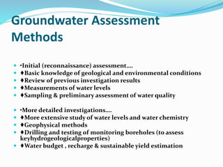
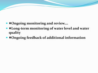
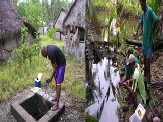
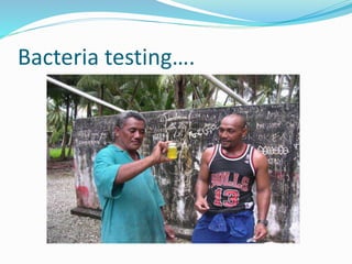
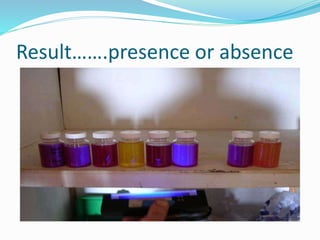
By
SATHISHKUMAR G
(sathishsak111@gmail.com)
Groundwater Assessment
Methods
 •Initial (reconnaissance) assessment….
 ♦Basic knowledge of geological and environmental conditions
 ♦Review of previous investigation results
 ♦Measurements of water levels
 ♦Sampling & preliminary assessment of water quality
 •More detailed investigations….
 ♦More extensive study of water levels and water chemistry
 ♦Geophysical methods
 ♦Drilling and testing of monitoring boreholes (to assess
keyhydrogeologicalproperties)
 ♦Water budget , recharge & sustainable yield estimation
 ♦Ongoing monitoring and review….
 ♦Long-term monitoring of water level and water
quality
 ♦Ongoing feedback of additional information
Water level measurements
 •Periodic measurements….
 ♦standard tape measure (shallow wells)
 ♦‘dipmeter’: tape measure on reel with optiona
& buzzer (deep wells and boreholes)
 •Continuous measurements….
 ♦float connected to chart recorder or shaft
encoder and data logger. Instrumentation at
surface.
 ♦electronic pressure sensor with in-built data
logger. Installed below surface with cable to
surface to enable downloading of data from the
surface.
Water level measurements using
Dip meter….
General……….
 The Geosystems Water L e v e l I n d i c a t o r s
(Dipmeters) Model 1680- GS-DM Series are typically
used to measure the depth of water levels in boreholes,
standpipes or observation wells
Features………..
 Stretch resistant survey tape
 Tape marked in m, cm,mm
 Clear polyethylene coating on tape
 Corrosion resistance construction
 Sensitivity control test button
 Visible and audible indicators
 Replaceable 9V battery
 16 mm diameter probe
Description….
 The Water Level Indicator consists of a stainless steel
probe attached to a flat steel survey tape. The conductors
are stainless steel and the tape/conductor assembly is
encapsulated in a tough, clear plastic coating.
 The tape and indicator unit are fitted with high grade
bearings for ease of operation.
 The reel is supplied with a roller guide to protect the tape
from damage at the top of the standpipe.
Operation….
 In operation, the probe is lowered down the open bore
until it comes into contact with the water surface. This
completes the circuit and activates an alarm.
 The operator then reads the depth of the probe off the
tape at the collar.
 The probe features a sensitive control to eliminate false
water level readings due to dripping water.
Water quality measurements ….
 •Periodic measurements
 ♦sampling using appropriate bottles and
methods:
 -bailer
 -sampling pump
 and testing on-site or later in laboratory.
 ♦using portable instruments (e.g. salinity
meter)
 •Continuous measurements
 ♦selected water quality parameters (e.g. salinity,
dissolved oxygen, specific ions) using sensors with in-
built data logger. Can download data from the surface.
Bacteria testing….
Result…….presence or absence
THANK YOU

GROUND WATER ASSESSMENT METHOD’S

  • 1.
  • 2.
    Groundwater Assessment Methods  •Initial(reconnaissance) assessment….  ♦Basic knowledge of geological and environmental conditions  ♦Review of previous investigation results  ♦Measurements of water levels  ♦Sampling & preliminary assessment of water quality  •More detailed investigations….  ♦More extensive study of water levels and water chemistry  ♦Geophysical methods  ♦Drilling and testing of monitoring boreholes (to assess keyhydrogeologicalproperties)  ♦Water budget , recharge & sustainable yield estimation
  • 3.
     ♦Ongoing monitoringand review….  ♦Long-term monitoring of water level and water quality  ♦Ongoing feedback of additional information
  • 4.
    Water level measurements •Periodic measurements….  ♦standard tape measure (shallow wells)  ♦‘dipmeter’: tape measure on reel with optiona & buzzer (deep wells and boreholes)
  • 5.
     •Continuous measurements…. ♦float connected to chart recorder or shaft encoder and data logger. Instrumentation at surface.  ♦electronic pressure sensor with in-built data logger. Installed below surface with cable to surface to enable downloading of data from the surface.
  • 6.
    Water level measurementsusing Dip meter….
  • 8.
    General……….  The GeosystemsWater L e v e l I n d i c a t o r s (Dipmeters) Model 1680- GS-DM Series are typically used to measure the depth of water levels in boreholes, standpipes or observation wells
  • 9.
    Features………..  Stretch resistantsurvey tape  Tape marked in m, cm,mm  Clear polyethylene coating on tape  Corrosion resistance construction  Sensitivity control test button  Visible and audible indicators  Replaceable 9V battery  16 mm diameter probe
  • 10.
    Description….  The WaterLevel Indicator consists of a stainless steel probe attached to a flat steel survey tape. The conductors are stainless steel and the tape/conductor assembly is encapsulated in a tough, clear plastic coating.  The tape and indicator unit are fitted with high grade bearings for ease of operation.  The reel is supplied with a roller guide to protect the tape from damage at the top of the standpipe.
  • 11.
    Operation….  In operation,the probe is lowered down the open bore until it comes into contact with the water surface. This completes the circuit and activates an alarm.  The operator then reads the depth of the probe off the tape at the collar.  The probe features a sensitive control to eliminate false water level readings due to dripping water.
  • 12.
    Water quality measurements….  •Periodic measurements  ♦sampling using appropriate bottles and methods:  -bailer  -sampling pump  and testing on-site or later in laboratory.  ♦using portable instruments (e.g. salinity meter)
  • 13.
     •Continuous measurements ♦selected water quality parameters (e.g. salinity, dissolved oxygen, specific ions) using sensors with in- built data logger. Can download data from the surface.
  • 15.
  • 16.
  • 17.