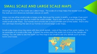
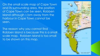
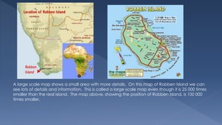
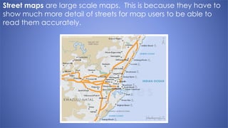
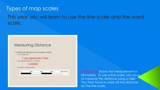
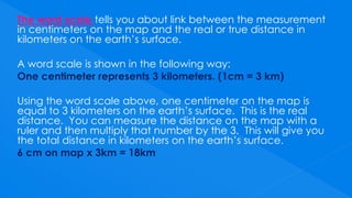
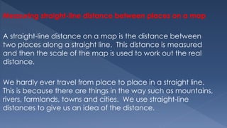
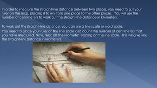
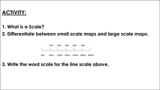
3. Scale
This is the method used to work
out the real distance as it would
be on the earth from a map.
4. Drawings of areas of the world are called maps. The scale of a map helps the reader work out
the real size and distances between places on earth.
Maps can be either small scale or large scale. Because the world, in reality, is so large, if we want
to show it on a map we have to make the world smaller. That is why we call maps showing the
world small scale maps. Our homes and schools are a much smaller part of the world. That is why
we call maps showing the size of our homes or schools large scale maps.
Small scale maps show big areas with few small details. Look at the map of the world, below. It is
an example of a small scale map. It shows the entire area the world, but a lot of the details are
missing. You are able to see the earth, but the map is too small to see any details such as rivers,
towns and roads.
5. On the small scale map of Cape Town
and its surrounding area, the position
of Cape Town can be seen, Robben
Island although 11km away from the
harbour in Cape Town cannot be
seen.
The reason why you cannot find
Robben Island is because this is a small
scale map. Robben Island is too small
to be shown on this map.
6. A large scale map shows a small area with more details. On this map of Robben Island we can
see lots of details and information. This is called a large scale map even though it is 25 000 times
smaller than the real island. The map above, showing the position of Robben Island, is 100 000
times smaller.
7. Street maps are large scale maps. This is because they have to
show much more detail of streets for map users to be able to
read them accurately.
8. KEY WORDS
Line scale: This is a line on the bottom of a map that shows
measurements in kilometers.
Word scale: Words are used to tell you how to work out distance
on the map.
9. Types of map scales
A line scale shows the measurement in
kilometers. To use a line scale, you have
to measure the distance using a ruler.
You then have to mark off the distance
on the line scale.
10. The word scale tells you about link between the measurement
in centimeters on the map and the real or true distance in
kilometers on the earth’s surface.
A word scale is shown in the following way:
One centimeter represents 3 kilometers. (1cm = 3 km)
Using the word scale above, one centimeter on the map is
equal to 3 kilometers on the earth’s surface. This is the real
distance. You can measure the distance on the map with a
ruler and then multiply that number by the 3. This will give you
the total distance in kilometers on the earth’s surface.
6 cm on map x 3km = 18km
11. Measuring straight-line distance between places on a map
A straight-line distance on a map is the distance between
two places along a straight line. This distance is measured
and then the scale of the map is used to work out the real
distance.
We hardly ever travel from place to place in a straight line.
This is because there are things in the way such as mountains,
rivers, farmlands, towns and cities. We use straight-line
distances to give us an idea of the distance.
12. In order to measure the straight-line distance between two places, you need to put your
ruler on the map, placing it to run from one place to the other places. You will use the
number of centimeters to work out the straight-line distance in kilometers.
To work out the straight-line distance, you can use a line scale or word scale.
You need to place your ruler on the line scale and count the number of centimeters that
you have measured. Now, read off the kilometer reading on the line scale. This will give you
the straight-line distance in kilometers.
13. ACTIVITY:
1. What is a Scale?
2. Differentiate between small scale maps and large scale maps.
1cm 2cm 3cm 4cm 5cm
3. Write the word scale for the line scale above.
0km 60km 120km 180km 240km 300km 360km