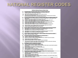
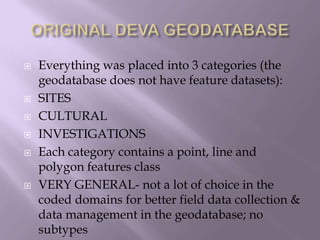
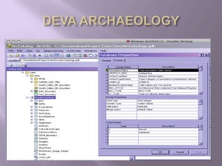
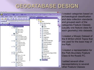
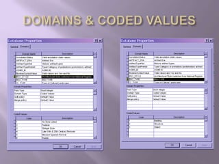
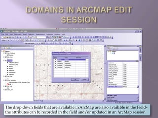
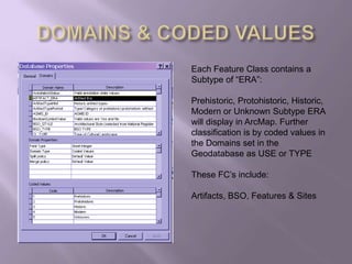
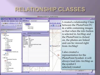
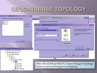
GISG 114GEODATABASEPROJECT:	DEVA ArchaeologyDesigned by: Janelle Harrison
DESIGNING THE GEODATABASE I wanted to integrate properties from the geodatabase I worked in for California State Parks and from Death Valley National Park; yet modify that which I didn’t like in both.Archaeological data collection based on codes for Cultural Resources:State of California has unique set of codesNPS has specific codes and terminology
DESIGN REQUIREMENTSNPS archaeologists need specific data collected in the field to complete online Archaeological Site Information Management System (ASMIS) forms.ASMIS is NPS archaeological record keeping systemAll archaeological sites must have a state site record on standard DPR formsI based my domains & subtypes on the codes used for both ASMIS and DPR forms
CALIFORNIA SITE RECORDSINSTRUCTIONS FOR RECORDINGHISTORICAL RESOURCESOffice of Historic PreservationP.O. Box 942896Sacramento, CA 942196-0001I USED APPENDIX 4: RESOURCE ATTRIBUTE CODES    for my coded values
Resource Attribute Codes
NPS RESOURCE CODESThe National Register for Historic Places (NRHP).State of California uses the NRHP status coded for Standard DPR site recordsState & Federal use BSO (Building, Structure, Object) for Historic I used the NRHP Architectural Styles as coded values for my BSO_Style domain
NATIONAL REGISTER CODES
ORIGINAL DEVA GEODATABASEEverything was placed into 3 categories (the geodatabase does not have feature datasets):SITESCULTURALINVESTIGATIONSEach category contains a point, line and polygon features classVERY GENERAL- not a lot of choice in the coded domains for better field data collection & data management in the geodatabase; no subtypes
DEVA_ARCH
	DEVA_ARCHThe Geodatabase design used mostly “TEXT”  Field Types for the feature class domainsThe domains were limited in descriptive dropdown fields and rarely represented the types of sites/artifacts and features found in Death ValleyOr as classified by the California Office of Historic Preservation
DEVA_ARCHThe lack of useable coded domains or subtypes and no real subtypes other than ERA left little options in specification during map production and when querying data from attribute table
	MY GEODATABASE DESIGNI created most of my Domains as SI I created coded values to chose from in most “descriptive” fields i.e. artifact type, building type, feature type and used the resource codes used on DPR Site Records and ASMIS/ NRHP codes so that data can be queried by these codes, site records can be completed more efficiently and NPS employees working in California can learn DPR site record coding while working in the field collecting data
DEVA ARCHAEOLOGY
GEODATABASE DESIGNI created categories based on archaeological classification and data collection standards and grouped each of the categories Feature Classes (usually one feature class for each geometry) into datasets.I created a Mosaic Dataset of the 8 MrSid USGS Topos that are used for the base map of the ParkI created a representation for the Park Boundary Feature Class & the Roads FC.I added several other representations to several other Feature Classes
DOMAINS & CODED VALUES
DOMAINS IN ARCMAP EDIT SESSIONThe drop down fields that are available in ArcMap are also available in the Field- the attributes can be recorded in the field and/or updated in an ArcMap session
DOMAINS IN ARCMAP EDIT SESSIONThe drop down fields contain descriptive attributes to select from in ArcMap or in the field
DOMAINS IN ARCMAP EDIT SESSIONThe drop down fields contain descriptive attributes to select from in ArcMap or in the field.There is also a DESCRITION FIELD that allows the user to type in a description/comment
DOMAINS IN ARCMAP EDIT SESSIONThe Domains coded values are the same codes used on standard DPR site records
DOMAINS IN ARCMAP EDIT SESSIONThe Domains coded values are the same codes used on standard DPR site recordsAt first I was only going to enter codes that would most likely be found in Death Valley and not add those most likely not to be found, such as a shipwreck or a Lighthouse but then decided to enter all codes so that the user could become familar with all of them and to not have “gaps” in the codes.
DOMAINS & CODED VALUESEach Feature Class contains a Subtype of “ERA”:Prehistoric, Protohistoric, Historic, Modern or Unknown Subtype ERA will display in ArcMap. Further classification is by coded values in the Domains set in the Geodatabase as USE or TYPEThese FC’s include:Artifacts, BSO, Features & Sites
REPRESENATATIONSMY ROADS LOAD WITH THE SET REPRESENTATIONS
RELATIONSHIP CLASSESI created a relationship Class between the PhotoPoint FC & a table containing images so that when the info button is selected in ArcMap and the PhotoPoint is clicked on, the photos are linked and can be viewed right from ArcMap!I also created a representation for the PhotoPoint Symbol- it will always load into ArcMap as the symbol I selected/created
GEODATABASE TOPOLOGYBSO, FEATURE & SITE FC’s have Polygon Topology Rules to prevent Polygon overlapping.
CONCLUSIONIN THE PROCESS OF DESIGING AND BUILDING AND FINALLY TESTING MY GEODATABASE DESIGN:I have concluded that this design is much more functional for a National Park then the geodatabase I worked with previously but,I also found several areas that could be improved!

GISG 114 Geodatabase Project

  • 1.
  • 2.
    DESIGNING THE GEODATABASEI wanted to integrate properties from the geodatabase I worked in for California State Parks and from Death Valley National Park; yet modify that which I didn’t like in both.Archaeological data collection based on codes for Cultural Resources:State of California has unique set of codesNPS has specific codes and terminology
  • 3.
    DESIGN REQUIREMENTSNPS archaeologistsneed specific data collected in the field to complete online Archaeological Site Information Management System (ASMIS) forms.ASMIS is NPS archaeological record keeping systemAll archaeological sites must have a state site record on standard DPR formsI based my domains & subtypes on the codes used for both ASMIS and DPR forms
  • 4.
    CALIFORNIA SITE RECORDSINSTRUCTIONSFOR RECORDINGHISTORICAL RESOURCESOffice of Historic PreservationP.O. Box 942896Sacramento, CA 942196-0001I USED APPENDIX 4: RESOURCE ATTRIBUTE CODES for my coded values
  • 5.
  • 6.
    NPS RESOURCE CODESTheNational Register for Historic Places (NRHP).State of California uses the NRHP status coded for Standard DPR site recordsState & Federal use BSO (Building, Structure, Object) for Historic I used the NRHP Architectural Styles as coded values for my BSO_Style domain
  • 7.
  • 8.
    ORIGINAL DEVA GEODATABASEEverythingwas placed into 3 categories (the geodatabase does not have feature datasets):SITESCULTURALINVESTIGATIONSEach category contains a point, line and polygon features classVERY GENERAL- not a lot of choice in the coded domains for better field data collection & data management in the geodatabase; no subtypes
  • 9.
  • 10.
    DEVA_ARCHThe Geodatabase designused mostly “TEXT” Field Types for the feature class domainsThe domains were limited in descriptive dropdown fields and rarely represented the types of sites/artifacts and features found in Death ValleyOr as classified by the California Office of Historic Preservation
  • 11.
    DEVA_ARCHThe lack ofuseable coded domains or subtypes and no real subtypes other than ERA left little options in specification during map production and when querying data from attribute table
  • 12.
    MY GEODATABASE DESIGNIcreated most of my Domains as SI I created coded values to chose from in most “descriptive” fields i.e. artifact type, building type, feature type and used the resource codes used on DPR Site Records and ASMIS/ NRHP codes so that data can be queried by these codes, site records can be completed more efficiently and NPS employees working in California can learn DPR site record coding while working in the field collecting data
  • 13.
  • 14.
    GEODATABASE DESIGNI createdcategories based on archaeological classification and data collection standards and grouped each of the categories Feature Classes (usually one feature class for each geometry) into datasets.I created a Mosaic Dataset of the 8 MrSid USGS Topos that are used for the base map of the ParkI created a representation for the Park Boundary Feature Class & the Roads FC.I added several other representations to several other Feature Classes
  • 15.
  • 16.
  • 17.
    DOMAINS IN ARCMAPEDIT SESSIONThe drop down fields that are available in ArcMap are also available in the Field- the attributes can be recorded in the field and/or updated in an ArcMap session
  • 18.
    DOMAINS IN ARCMAPEDIT SESSIONThe drop down fields contain descriptive attributes to select from in ArcMap or in the field
  • 19.
    DOMAINS IN ARCMAPEDIT SESSIONThe drop down fields contain descriptive attributes to select from in ArcMap or in the field.There is also a DESCRITION FIELD that allows the user to type in a description/comment
  • 20.
    DOMAINS IN ARCMAPEDIT SESSIONThe Domains coded values are the same codes used on standard DPR site records
  • 21.
    DOMAINS IN ARCMAPEDIT SESSIONThe Domains coded values are the same codes used on standard DPR site recordsAt first I was only going to enter codes that would most likely be found in Death Valley and not add those most likely not to be found, such as a shipwreck or a Lighthouse but then decided to enter all codes so that the user could become familar with all of them and to not have “gaps” in the codes.
  • 22.
    DOMAINS & CODEDVALUESEach Feature Class contains a Subtype of “ERA”:Prehistoric, Protohistoric, Historic, Modern or Unknown Subtype ERA will display in ArcMap. Further classification is by coded values in the Domains set in the Geodatabase as USE or TYPEThese FC’s include:Artifacts, BSO, Features & Sites
  • 23.
    REPRESENATATIONSMY ROADS LOADWITH THE SET REPRESENTATIONS
  • 24.
    RELATIONSHIP CLASSESI createda relationship Class between the PhotoPoint FC & a table containing images so that when the info button is selected in ArcMap and the PhotoPoint is clicked on, the photos are linked and can be viewed right from ArcMap!I also created a representation for the PhotoPoint Symbol- it will always load into ArcMap as the symbol I selected/created
  • 25.
    GEODATABASE TOPOLOGYBSO, FEATURE& SITE FC’s have Polygon Topology Rules to prevent Polygon overlapping.
  • 26.
    CONCLUSIONIN THE PROCESSOF DESIGING AND BUILDING AND FINALLY TESTING MY GEODATABASE DESIGN:I have concluded that this design is much more functional for a National Park then the geodatabase I worked with previously but,I also found several areas that could be improved!