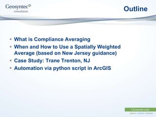
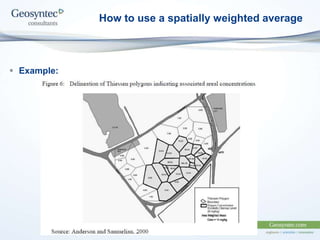
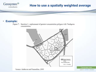
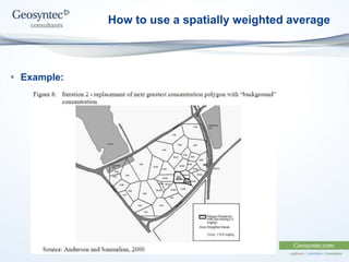
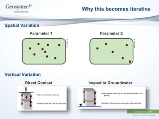
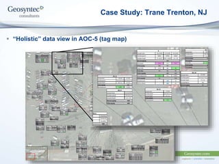
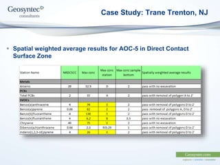
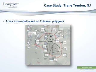
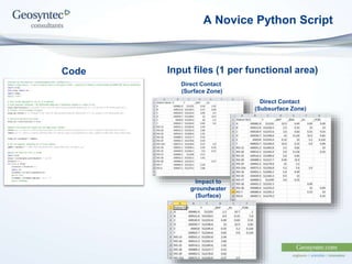
GIS and Database Action Group (GDAG) Conference 2014
Joe Luchette (JLuchette@geosyntec.com Princeton, NJ)
Tom Geiger (TGeiger@geosyntec.com Princeton, NJ)
Compliance Averaging
using Spatially Weighted Average Methodology
Outline
 What is Compliance Averaging
 When and How to Use a Spatially Weighted
Average (based on New Jersey guidance)
 Case Study: Trane Trenton, NJ
 Automation via python script in ArcGIS
What is Compliance Averaging
 Compliance Averaging is…
 “… statistical tests to allow for identification and elimination of data
outliers” (http://www.nj.gov/dep/srp/guidance/srra/attainment_compliance.pdf)
 Methods:
 Arithmetic mean for the data set where there are two or fewer distinct
sample values or nine or fewer total sample points
 95 percent upper confidence limit (UCL) of the mean
 Spatially weighted average (e.g., Thiessen polygons)
 75 percent/10x procedure (Post Remediation)
When to use a spatially weighted average
 Your impacts must be horizontally and vertically delineated
(to apply any compliance averaging)
 Typically used when other methods don’t work
 Currently only applies to soil contamination in NJ
 Direct Contact Soil Remediation Standards (SRS)
 Impact to Groundwater Soil Screening Levels (SSL)
How to use a spatially weighted average
 1. Define Functional Area (this also applies to 95% UCL)
A. Shape:
 Site or AOC boundary, Square (preferred) or Rectangle
B. Total Area:
 Max 0.5 acres (Residential Direct contact),
 Max 2.0 acres (Non-Res Direct contact),
 Min 100 ft length in direction parallel to groundwater flow. (IGW)
C. Depth Zones:
Direct Contact Impact to Groundwater
(Take max in each zone) (Take max in each zone)
How to use a spatially weighted average
 2. Create Thiessen/Voronoi polygons from point dataset
 3: Add field (double) & calculate area for polygons (units are
arbitrary)
 4: Add field (double) & multiply area by concentration
 5: Spatially weighted mean = the sum of the weighted results
divided by the total area (same units)
 6: Evaluate:
 If this is less than the applicable standard, you are done!
 Else, if this is still above the standard, take out the polygon with
the highest result, and start over at step 2.
 Iterate until complete.
How to use a spatially weighted average
 Example:
How to use a spatially weighted average
 Example:
How to use a spatially weighted average
 Example:
How to use a spatially weighted average
 Example:
How to use a spatially weighted average
 Example:
How to use a spatially weighted average
 Example:
Significant reduction in “impacted” area requiring remedial action
Why this becomes iterative
Spatial Variation
Vertical Variation
Parameter 1 Parameter 2
Direct Contact Impact to Groundwater
Case Study: Trane Trenton, NJ
 Operational Manufacturing Site (approx. 30 acres)
 Several Historic AOCs
 20+ years of soil data
 Remediation standard exceedances in direct contact surface and
subsurface as well as impact to groundwater surface and
subsurface.
Case Study: Trane Trenton, NJ
 “Holistic” data view in AOC-5 (tag map)
Case Study: Trane Trenton, NJ
 Spatial weighted average results for AOC-5 in Direct Contact
Surface Zone
Case Study: Trane Trenton, NJ
 Areas excavated based on Thiessen polygons
A Novice Python Script
Code Input files (1 per functional area)
Direct Contact
(Surface Zone)
Direct Contact
(Subsurface Zone)
Impact to
groundwater
(Surface)
A Novice Python Script

GIS Spatially Weighted Averages

  • 1.
    GIS and DatabaseAction Group (GDAG) Conference 2014 Joe Luchette (JLuchette@geosyntec.com Princeton, NJ) Tom Geiger (TGeiger@geosyntec.com Princeton, NJ) Compliance Averaging using Spatially Weighted Average Methodology
  • 2.
    Outline  What isCompliance Averaging  When and How to Use a Spatially Weighted Average (based on New Jersey guidance)  Case Study: Trane Trenton, NJ  Automation via python script in ArcGIS
  • 3.
    What is ComplianceAveraging  Compliance Averaging is…  “… statistical tests to allow for identification and elimination of data outliers” (http://www.nj.gov/dep/srp/guidance/srra/attainment_compliance.pdf)  Methods:  Arithmetic mean for the data set where there are two or fewer distinct sample values or nine or fewer total sample points  95 percent upper confidence limit (UCL) of the mean  Spatially weighted average (e.g., Thiessen polygons)  75 percent/10x procedure (Post Remediation)
  • 4.
    When to usea spatially weighted average  Your impacts must be horizontally and vertically delineated (to apply any compliance averaging)  Typically used when other methods don’t work  Currently only applies to soil contamination in NJ  Direct Contact Soil Remediation Standards (SRS)  Impact to Groundwater Soil Screening Levels (SSL)
  • 5.
    How to usea spatially weighted average  1. Define Functional Area (this also applies to 95% UCL) A. Shape:  Site or AOC boundary, Square (preferred) or Rectangle B. Total Area:  Max 0.5 acres (Residential Direct contact),  Max 2.0 acres (Non-Res Direct contact),  Min 100 ft length in direction parallel to groundwater flow. (IGW) C. Depth Zones: Direct Contact Impact to Groundwater (Take max in each zone) (Take max in each zone)
  • 6.
    How to usea spatially weighted average  2. Create Thiessen/Voronoi polygons from point dataset  3: Add field (double) & calculate area for polygons (units are arbitrary)  4: Add field (double) & multiply area by concentration  5: Spatially weighted mean = the sum of the weighted results divided by the total area (same units)  6: Evaluate:  If this is less than the applicable standard, you are done!  Else, if this is still above the standard, take out the polygon with the highest result, and start over at step 2.  Iterate until complete.
  • 7.
    How to usea spatially weighted average  Example:
  • 8.
    How to usea spatially weighted average  Example:
  • 9.
    How to usea spatially weighted average  Example:
  • 10.
    How to usea spatially weighted average  Example:
  • 11.
    How to usea spatially weighted average  Example:
  • 12.
    How to usea spatially weighted average  Example: Significant reduction in “impacted” area requiring remedial action
  • 13.
    Why this becomesiterative Spatial Variation Vertical Variation Parameter 1 Parameter 2 Direct Contact Impact to Groundwater
  • 14.
    Case Study: TraneTrenton, NJ  Operational Manufacturing Site (approx. 30 acres)  Several Historic AOCs  20+ years of soil data  Remediation standard exceedances in direct contact surface and subsurface as well as impact to groundwater surface and subsurface.
  • 15.
    Case Study: TraneTrenton, NJ  “Holistic” data view in AOC-5 (tag map)
  • 16.
    Case Study: TraneTrenton, NJ  Spatial weighted average results for AOC-5 in Direct Contact Surface Zone
  • 17.
    Case Study: TraneTrenton, NJ  Areas excavated based on Thiessen polygons
  • 18.
    A Novice PythonScript Code Input files (1 per functional area) Direct Contact (Surface Zone) Direct Contact (Subsurface Zone) Impact to groundwater (Surface)
  • 19.