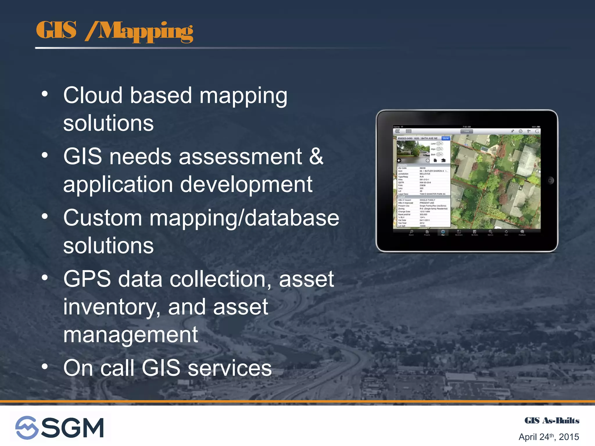
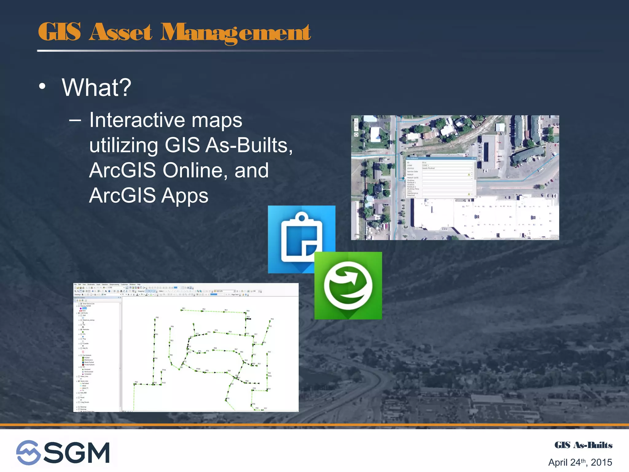
SlideShare a Scribd company logo
1 of 10
April 24th
, 2015
GIS Colorado 2015 Spring Meeting
GIS As-Builts and Asset Management
for Municipalities
Chris Lehrman, PE MunicipalEng ine e r
Rachel Kattnig, GIS Te chnician
GIS As-Builts
April 24th
, 2015
Providing engineering
and surveying
services
since 1986
Locations in:
Aspen | Glenwood Springs | Gunnison |
Salida | Meeker | Grand Junction
Introduction
GIS As-Builts
April 24th
, 2015
Technical areas of Expertise
Structural
Survey
MEP
Land Development
Transportation
Water Resources
Water Rights
Introduction
GIS Mapping
Energy
Wastewater
Drinking Water
Municipal
Asset Management
Construction Services
GIS As-Builts
April 24th
, 2015
• Cloud based mapping
solutions
• GIS needs assessment &
application development
• Custom mapping/database
solutions
• GPS data collection, asset
inventory, and asset
management
• On call GIS services
GIS /Mapping
GIS As-Builts
April 24th
, 2015
• What?
– Data rich GIS maps
• How?
– Collect GIS data in field with GPS
• Location, photos, install date, manufacturer, model, notes
• Custom data dictionaries based on project
• Why?
– Pre-populate GIS map with accurate info at low cost
during construction.
– Client can see progress of project.
– No digitizing; makes GIS staff happy!
– Makes field personnel happy!
GIS As-Builts
GIS As-Builts
April 24th
, 2015
• Benefits
– Feature location
– Avoidance of misplaced data and info
– Ability to easily convert data to multiple formats
– Track editing: who, when and what
– Ease of access and retrieval of data to and from
clients and other entities .
– Sets foundation for asset management
GIS As-Builts
GIS As-Builts
April 24th
, 2015
GIS Asset Management
• What?
– Interactive maps
utilizing GIS As-Builts,
ArcGIS Online, and
ArcGIS Apps
GIS As-Builts
April 24th
, 2015
• How?
– Collaboration with clients
• Identify infrastructure and needs
• Create custom maintenance maps based on project
• Why?
– Ease of use
– Help track what features need additional work
– Ability to share and limit editing capabilities
– Makes field personnel happy!
GIS Asset Management
GIS As-Builts
April 24th
, 2015
Q & A
Conclusion
GIS As-Builts
April 24th
, 2015
SGMCompany Contacts – GIS Mapping
Chris Lehrman, PE, GIS Team Leader
970.384.9043
chrisl@sgm-inc.com
Steven Kirk, GIS Analyst
970.384.9062
stevenk@sgm-inc.com
Rachel Kattnig, GIS Technician
970.384.9064
rachelk@sgm-inc.com

More Related Content

What's hot

Esri Scotland Conf 2016 Forestry Commission
Esri Scotland Conf 2016   Forestry CommissionEsri Scotland Conf 2016   Forestry Commission
Esri Scotland Conf 2016 Forestry CommissionEsri UK
 
Working with arcgis online
Working with arcgis onlineWorking with arcgis online
Working with arcgis onlinezmmin383
 
Day1 concurrent fellows
Day1 concurrent fellowsDay1 concurrent fellows
Day1 concurrent fellowstoptrails
 
Sweet - Esri UK
Sweet - Esri UKSweet - Esri UK
Sweet - Esri UKEsri UK
 
Geographic Approach: Building Geospatial Capacity for an Agency
Geographic Approach: Building Geospatial Capacity for an AgencyGeographic Approach: Building Geospatial Capacity for an Agency
Geographic Approach: Building Geospatial Capacity for an AgencyMEASURE Evaluation
 
Designing and Using Cached Map
Designing and Using Cached Map Designing and Using Cached Map
Designing and Using Cached Map M.Muneeb Ashraf
 
Arcadis - Improving Ground Engineering Data Flows - Smart Infrastructure - AC18
Arcadis - Improving Ground Engineering Data Flows - Smart Infrastructure - AC18Arcadis - Improving Ground Engineering Data Flows - Smart Infrastructure - AC18
Arcadis - Improving Ground Engineering Data Flows - Smart Infrastructure - AC18Esri UK
 
Imagery Bundles for ArcGIS
 Imagery Bundles for ArcGIS Imagery Bundles for ArcGIS
Imagery Bundles for ArcGISSteve Snow
 
Portal for ArcGIS
Portal for ArcGISPortal for ArcGIS
Portal for ArcGISEsri
 
GIS as a Platform by Sam Viana (Esri Inc)
GIS as a Platform by Sam Viana (Esri Inc)GIS as a Platform by Sam Viana (Esri Inc)
GIS as a Platform by Sam Viana (Esri Inc)Esri South Africa
 
Agriculture Digital Innovation Hub
Agriculture Digital Innovation HubAgriculture Digital Innovation Hub
Agriculture Digital Innovation Hubplan4all
 
Esri UC 2016 - Central San and the Local Government Information Model
Esri UC 2016 - Central San and the Local Government Information ModelEsri UC 2016 - Central San and the Local Government Information Model
Esri UC 2016 - Central San and the Local Government Information ModelCarl Von Stetten
 
NDGeospatialSummit2019 - ArcGIS Enterprise – Power Your Location Intelligence
NDGeospatialSummit2019 - ArcGIS Enterprise – Power Your Location IntelligenceNDGeospatialSummit2019 - ArcGIS Enterprise – Power Your Location Intelligence
NDGeospatialSummit2019 - ArcGIS Enterprise – Power Your Location IntelligenceNorth Dakota GIS Hub
 
Esri 2016 User Conference - ArcGIS Online steps for success
Esri 2016 User Conference - ArcGIS Online steps for successEsri 2016 User Conference - ArcGIS Online steps for success
Esri 2016 User Conference - ArcGIS Online steps for successBern Szukalski
 
Visualising Lidar Data in ArcGIS Pro - Training - Esri UK Annual Conference 2017
Visualising Lidar Data in ArcGIS Pro - Training - Esri UK Annual Conference 2017Visualising Lidar Data in ArcGIS Pro - Training - Esri UK Annual Conference 2017
Visualising Lidar Data in ArcGIS Pro - Training - Esri UK Annual Conference 2017Esri UK
 
NDGeospatialSummit2019 - What’s New with ArcGIS – Highlights From the 2019 UC
NDGeospatialSummit2019 - What’s New with ArcGIS – Highlights From the 2019 UC NDGeospatialSummit2019 - What’s New with ArcGIS – Highlights From the 2019 UC
NDGeospatialSummit2019 - What’s New with ArcGIS – Highlights From the 2019 UC North Dakota GIS Hub
 
NDGeospatialSummit2019 - ArcGIS Pro – Next-Generation Desktop GIS
NDGeospatialSummit2019 - ArcGIS Pro – Next-Generation Desktop GISNDGeospatialSummit2019 - ArcGIS Pro – Next-Generation Desktop GIS
NDGeospatialSummit2019 - ArcGIS Pro – Next-Generation Desktop GISNorth Dakota GIS Hub
 

What's hot (20)

Esri Scotland Conf 2016 Forestry Commission
Esri Scotland Conf 2016   Forestry CommissionEsri Scotland Conf 2016   Forestry Commission
Esri Scotland Conf 2016 Forestry Commission
 
Working with arcgis online
Working with arcgis onlineWorking with arcgis online
Working with arcgis online
 
Day1 concurrent fellows
Day1 concurrent fellowsDay1 concurrent fellows
Day1 concurrent fellows
 
Sweet - Esri UK
Sweet - Esri UKSweet - Esri UK
Sweet - Esri UK
 
Kristin Walker's resume
Kristin Walker's resumeKristin Walker's resume
Kristin Walker's resume
 
URS in Dynamics 365
URS in Dynamics 365URS in Dynamics 365
URS in Dynamics 365
 
Web GIS
Web GISWeb GIS
Web GIS
 
Geographic Approach: Building Geospatial Capacity for an Agency
Geographic Approach: Building Geospatial Capacity for an AgencyGeographic Approach: Building Geospatial Capacity for an Agency
Geographic Approach: Building Geospatial Capacity for an Agency
 
Designing and Using Cached Map
Designing and Using Cached Map Designing and Using Cached Map
Designing and Using Cached Map
 
Arcadis - Improving Ground Engineering Data Flows - Smart Infrastructure - AC18
Arcadis - Improving Ground Engineering Data Flows - Smart Infrastructure - AC18Arcadis - Improving Ground Engineering Data Flows - Smart Infrastructure - AC18
Arcadis - Improving Ground Engineering Data Flows - Smart Infrastructure - AC18
 
Imagery Bundles for ArcGIS
 Imagery Bundles for ArcGIS Imagery Bundles for ArcGIS
Imagery Bundles for ArcGIS
 
Portal for ArcGIS
Portal for ArcGISPortal for ArcGIS
Portal for ArcGIS
 
GIS as a Platform by Sam Viana (Esri Inc)
GIS as a Platform by Sam Viana (Esri Inc)GIS as a Platform by Sam Viana (Esri Inc)
GIS as a Platform by Sam Viana (Esri Inc)
 
Agriculture Digital Innovation Hub
Agriculture Digital Innovation HubAgriculture Digital Innovation Hub
Agriculture Digital Innovation Hub
 
Esri UC 2016 - Central San and the Local Government Information Model
Esri UC 2016 - Central San and the Local Government Information ModelEsri UC 2016 - Central San and the Local Government Information Model
Esri UC 2016 - Central San and the Local Government Information Model
 
NDGeospatialSummit2019 - ArcGIS Enterprise – Power Your Location Intelligence
NDGeospatialSummit2019 - ArcGIS Enterprise – Power Your Location IntelligenceNDGeospatialSummit2019 - ArcGIS Enterprise – Power Your Location Intelligence
NDGeospatialSummit2019 - ArcGIS Enterprise – Power Your Location Intelligence
 
Esri 2016 User Conference - ArcGIS Online steps for success
Esri 2016 User Conference - ArcGIS Online steps for successEsri 2016 User Conference - ArcGIS Online steps for success
Esri 2016 User Conference - ArcGIS Online steps for success
 
Visualising Lidar Data in ArcGIS Pro - Training - Esri UK Annual Conference 2017
Visualising Lidar Data in ArcGIS Pro - Training - Esri UK Annual Conference 2017Visualising Lidar Data in ArcGIS Pro - Training - Esri UK Annual Conference 2017
Visualising Lidar Data in ArcGIS Pro - Training - Esri UK Annual Conference 2017
 
NDGeospatialSummit2019 - What’s New with ArcGIS – Highlights From the 2019 UC
NDGeospatialSummit2019 - What’s New with ArcGIS – Highlights From the 2019 UC NDGeospatialSummit2019 - What’s New with ArcGIS – Highlights From the 2019 UC
NDGeospatialSummit2019 - What’s New with ArcGIS – Highlights From the 2019 UC
 
NDGeospatialSummit2019 - ArcGIS Pro – Next-Generation Desktop GIS
NDGeospatialSummit2019 - ArcGIS Pro – Next-Generation Desktop GISNDGeospatialSummit2019 - ArcGIS Pro – Next-Generation Desktop GIS
NDGeospatialSummit2019 - ArcGIS Pro – Next-Generation Desktop GIS
 

Viewers also liked

Enterprise GIS Implementation for Public Infrastructure and Integration with ...
Enterprise GIS Implementation for Public Infrastructure and Integration with ...Enterprise GIS Implementation for Public Infrastructure and Integration with ...
Enterprise GIS Implementation for Public Infrastructure and Integration with ...Michael Baker Jr., Inc.
 
GOS Dashboard - Enterprise GIS Dashboard for Geodata.gov
GOS Dashboard - Enterprise GIS Dashboard for Geodata.govGOS Dashboard - Enterprise GIS Dashboard for Geodata.gov
GOS Dashboard - Enterprise GIS Dashboard for Geodata.govCarbon Project
 
Delivering Transformational Government through Enterprise GIS
Delivering Transformational Government through Enterprise GISDelivering Transformational Government through Enterprise GIS
Delivering Transformational Government through Enterprise GISJames Thompson
 
Philip O Doherty: Transforming Enterprise GIS through SaaS
Philip O Doherty: Transforming Enterprise GIS through SaaSPhilip O Doherty: Transforming Enterprise GIS through SaaS
Philip O Doherty: Transforming Enterprise GIS through SaaSAGI Geocommunity
 
Public Safety Enterprise: GIS Solutions for Community Protection and Response
Public Safety Enterprise: GIS Solutions for Community Protection and ResponsePublic Safety Enterprise: GIS Solutions for Community Protection and Response
Public Safety Enterprise: GIS Solutions for Community Protection and ResponseEsri
 
2013 Enterprise Track, Integrating People and Tools: Enterprise GIS Success S...
2013 Enterprise Track, Integrating People and Tools: Enterprise GIS Success S...2013 Enterprise Track, Integrating People and Tools: Enterprise GIS Success S...
2013 Enterprise Track, Integrating People and Tools: Enterprise GIS Success S...GIS in the Rockies
 
Mapping GIS to Enterprise Architecture and Analytics
Mapping GIS to Enterprise Architecture and AnalyticsMapping GIS to Enterprise Architecture and Analytics
Mapping GIS to Enterprise Architecture and AnalyticsDennis Crow
 
The GIS Capability Maturity Model Maximize Benefits from Enterprise GIS Opera...
The GIS Capability Maturity Model Maximize Benefits from Enterprise GIS Opera...The GIS Capability Maturity Model Maximize Benefits from Enterprise GIS Opera...
The GIS Capability Maturity Model Maximize Benefits from Enterprise GIS Opera...Greg Babinski
 
2016 gisco track: deploying an enterprise gis for the town of snowmass villag...
2016 gisco track: deploying an enterprise gis for the town of snowmass villag...2016 gisco track: deploying an enterprise gis for the town of snowmass villag...
2016 gisco track: deploying an enterprise gis for the town of snowmass villag...GIS in the Rockies
 
GIS enabled eGovernance
GIS enabled eGovernanceGIS enabled eGovernance
GIS enabled eGovernanceEsri India
 
GIS enabled State
GIS enabled StateGIS enabled State
GIS enabled StateEsri India
 
System Architecture of Cloud-based Web GIS for Real-Time Macroeconomic Loss E...
System Architecture of Cloud-based Web GIS for Real-Time Macroeconomic Loss E...System Architecture of Cloud-based Web GIS for Real-Time Macroeconomic Loss E...
System Architecture of Cloud-based Web GIS for Real-Time Macroeconomic Loss E...Reza Nourjou, Ph.D.
 

Viewers also liked (14)

Enterprise GIS Implementation for Public Infrastructure and Integration with ...
Enterprise GIS Implementation for Public Infrastructure and Integration with ...Enterprise GIS Implementation for Public Infrastructure and Integration with ...
Enterprise GIS Implementation for Public Infrastructure and Integration with ...
 
GOS Dashboard - Enterprise GIS Dashboard for Geodata.gov
GOS Dashboard - Enterprise GIS Dashboard for Geodata.govGOS Dashboard - Enterprise GIS Dashboard for Geodata.gov
GOS Dashboard - Enterprise GIS Dashboard for Geodata.gov
 
Lec w7 t_info_sys_arch
Lec w7 t_info_sys_archLec w7 t_info_sys_arch
Lec w7 t_info_sys_arch
 
Delivering Transformational Government through Enterprise GIS
Delivering Transformational Government through Enterprise GISDelivering Transformational Government through Enterprise GIS
Delivering Transformational Government through Enterprise GIS
 
Philip O Doherty: Transforming Enterprise GIS through SaaS
Philip O Doherty: Transforming Enterprise GIS through SaaSPhilip O Doherty: Transforming Enterprise GIS through SaaS
Philip O Doherty: Transforming Enterprise GIS through SaaS
 
Public Safety Enterprise: GIS Solutions for Community Protection and Response
Public Safety Enterprise: GIS Solutions for Community Protection and ResponsePublic Safety Enterprise: GIS Solutions for Community Protection and Response
Public Safety Enterprise: GIS Solutions for Community Protection and Response
 
The Evolving GIS Enterprise
The Evolving GIS EnterpriseThe Evolving GIS Enterprise
The Evolving GIS Enterprise
 
2013 Enterprise Track, Integrating People and Tools: Enterprise GIS Success S...
2013 Enterprise Track, Integrating People and Tools: Enterprise GIS Success S...2013 Enterprise Track, Integrating People and Tools: Enterprise GIS Success S...
2013 Enterprise Track, Integrating People and Tools: Enterprise GIS Success S...
 
Mapping GIS to Enterprise Architecture and Analytics
Mapping GIS to Enterprise Architecture and AnalyticsMapping GIS to Enterprise Architecture and Analytics
Mapping GIS to Enterprise Architecture and Analytics
 
The GIS Capability Maturity Model Maximize Benefits from Enterprise GIS Opera...
The GIS Capability Maturity Model Maximize Benefits from Enterprise GIS Opera...The GIS Capability Maturity Model Maximize Benefits from Enterprise GIS Opera...
The GIS Capability Maturity Model Maximize Benefits from Enterprise GIS Opera...
 
2016 gisco track: deploying an enterprise gis for the town of snowmass villag...
2016 gisco track: deploying an enterprise gis for the town of snowmass villag...2016 gisco track: deploying an enterprise gis for the town of snowmass villag...
2016 gisco track: deploying an enterprise gis for the town of snowmass villag...
 
GIS enabled eGovernance
GIS enabled eGovernanceGIS enabled eGovernance
GIS enabled eGovernance
 
GIS enabled State
GIS enabled StateGIS enabled State
GIS enabled State
 
System Architecture of Cloud-based Web GIS for Real-Time Macroeconomic Loss E...
System Architecture of Cloud-based Web GIS for Real-Time Macroeconomic Loss E...System Architecture of Cloud-based Web GIS for Real-Time Macroeconomic Loss E...
System Architecture of Cloud-based Web GIS for Real-Time Macroeconomic Loss E...
 

Similar to GIS As-Builts - How & Why

NDGeospatialSummit2019 - Enterprise GIS Success at McKenzie County
NDGeospatialSummit2019 - Enterprise GIS Success at McKenzie CountyNDGeospatialSummit2019 - Enterprise GIS Success at McKenzie County
NDGeospatialSummit2019 - Enterprise GIS Success at McKenzie CountyNorth Dakota GIS Hub
 
Leveraging ArcGIS Platform & CityEngine for GIS based Master Plans
Leveraging ArcGIS Platform & CityEngine for GIS based Master PlansLeveraging ArcGIS Platform & CityEngine for GIS based Master Plans
Leveraging ArcGIS Platform & CityEngine for GIS based Master PlansEsri India
 
Jayachandran Mani, Technical Officer, Head, Mission management at Karnataka S...
Jayachandran Mani, Technical Officer, Head, Mission management at Karnataka S...Jayachandran Mani, Technical Officer, Head, Mission management at Karnataka S...
Jayachandran Mani, Technical Officer, Head, Mission management at Karnataka S...Kathmandu Living Labs
 
King County Information Technology
King County Information TechnologyKing County Information Technology
King County Information TechnologyJamie Holter
 
Introduction to WebGIS- Esri norsk BK 2014
Introduction to WebGIS- Esri norsk BK 2014Introduction to WebGIS- Esri norsk BK 2014
Introduction to WebGIS- Esri norsk BK 2014Geodata AS
 
You Can’t Manage What you Don’t Measure URISA’s Proposed Municipal GIS Capab...
You Can’t Manage What you Don’t Measure  URISA’s Proposed Municipal GIS Capab...You Can’t Manage What you Don’t Measure  URISA’s Proposed Municipal GIS Capab...
You Can’t Manage What you Don’t Measure URISA’s Proposed Municipal GIS Capab...Greg Babinski
 
EDINA Geoservices: Geological Society Higher Education Network 2015
EDINA Geoservices: Geological Society Higher Education Network 2015EDINA Geoservices: Geological Society Higher Education Network 2015
EDINA Geoservices: Geological Society Higher Education Network 2015Tom Armitage
 
Julie Rediker GIS Professional
Julie Rediker GIS ProfessionalJulie Rediker GIS Professional
Julie Rediker GIS ProfessionalJulie Rediker
 
Full planning support system at your fingertips mvopc p&z_120712
Full planning support system at your fingertips mvopc p&z_120712Full planning support system at your fingertips mvopc p&z_120712
Full planning support system at your fingertips mvopc p&z_120712MVRPC
 
GIS at Sain Associates
GIS at Sain AssociatesGIS at Sain Associates
GIS at Sain AssociatesSainAssociates
 
MISA PRAIRIES 2013 - Flexibility in Delivering GIS Services
MISA PRAIRIES 2013 - Flexibility in Delivering GIS ServicesMISA PRAIRIES 2013 - Flexibility in Delivering GIS Services
MISA PRAIRIES 2013 - Flexibility in Delivering GIS ServicesTammy Kobliuk
 
From interoperable to interoperating Geosemantic resources; Practical example...
From interoperable to interoperating Geosemantic resources; Practical example...From interoperable to interoperating Geosemantic resources; Practical example...
From interoperable to interoperating Geosemantic resources; Practical example...Paul Cripps
 
AOS - GIS for Education
AOS - GIS for EducationAOS - GIS for Education
AOS - GIS for EducationNGINX at F5
 
Agi big 5 - BIM & Asset Management - James Colclough
Agi big 5 - BIM & Asset Management - James ColcloughAgi big 5 - BIM & Asset Management - James Colclough
Agi big 5 - BIM & Asset Management - James ColcloughJames Colclough
 
GIS in the Miami Valley Region
GIS in the Miami Valley RegionGIS in the Miami Valley Region
GIS in the Miami Valley RegionMVRPC
 
Mvrpcgis p&z 2016
Mvrpcgis p&z 2016Mvrpcgis p&z 2016
Mvrpcgis p&z 2016MVRPC
 
New paradigm for national mapping organization
New paradigm for national mapping organizationNew paradigm for national mapping organization
New paradigm for national mapping organizationEsri India
 
Using GIS as a maintenance management tool - APWA AZ
Using GIS as a maintenance management tool - APWA AZUsing GIS as a maintenance management tool - APWA AZ
Using GIS as a maintenance management tool - APWA AZRichard Chappell, GISP
 
Esriuk_track4_final_maria adamson
Esriuk_track4_final_maria adamsonEsriuk_track4_final_maria adamson
Esriuk_track4_final_maria adamsonEsri UK
 

Similar to GIS As-Builts - How & Why (20)

NDGeospatialSummit2019 - Enterprise GIS Success at McKenzie County
NDGeospatialSummit2019 - Enterprise GIS Success at McKenzie CountyNDGeospatialSummit2019 - Enterprise GIS Success at McKenzie County
NDGeospatialSummit2019 - Enterprise GIS Success at McKenzie County
 
Leveraging ArcGIS Platform & CityEngine for GIS based Master Plans
Leveraging ArcGIS Platform & CityEngine for GIS based Master PlansLeveraging ArcGIS Platform & CityEngine for GIS based Master Plans
Leveraging ArcGIS Platform & CityEngine for GIS based Master Plans
 
Jayachandran Mani, Technical Officer, Head, Mission management at Karnataka S...
Jayachandran Mani, Technical Officer, Head, Mission management at Karnataka S...Jayachandran Mani, Technical Officer, Head, Mission management at Karnataka S...
Jayachandran Mani, Technical Officer, Head, Mission management at Karnataka S...
 
King County Information Technology
King County Information TechnologyKing County Information Technology
King County Information Technology
 
Introduction to WebGIS- Esri norsk BK 2014
Introduction to WebGIS- Esri norsk BK 2014Introduction to WebGIS- Esri norsk BK 2014
Introduction to WebGIS- Esri norsk BK 2014
 
You Can’t Manage What you Don’t Measure URISA’s Proposed Municipal GIS Capab...
You Can’t Manage What you Don’t Measure  URISA’s Proposed Municipal GIS Capab...You Can’t Manage What you Don’t Measure  URISA’s Proposed Municipal GIS Capab...
You Can’t Manage What you Don’t Measure URISA’s Proposed Municipal GIS Capab...
 
EDINA Geoservices: Geological Society Higher Education Network 2015
EDINA Geoservices: Geological Society Higher Education Network 2015EDINA Geoservices: Geological Society Higher Education Network 2015
EDINA Geoservices: Geological Society Higher Education Network 2015
 
Julie Rediker GIS Professional
Julie Rediker GIS ProfessionalJulie Rediker GIS Professional
Julie Rediker GIS Professional
 
Web Based GIS
Web Based GISWeb Based GIS
Web Based GIS
 
Full planning support system at your fingertips mvopc p&z_120712
Full planning support system at your fingertips mvopc p&z_120712Full planning support system at your fingertips mvopc p&z_120712
Full planning support system at your fingertips mvopc p&z_120712
 
GIS at Sain Associates
GIS at Sain AssociatesGIS at Sain Associates
GIS at Sain Associates
 
MISA PRAIRIES 2013 - Flexibility in Delivering GIS Services
MISA PRAIRIES 2013 - Flexibility in Delivering GIS ServicesMISA PRAIRIES 2013 - Flexibility in Delivering GIS Services
MISA PRAIRIES 2013 - Flexibility in Delivering GIS Services
 
From interoperable to interoperating Geosemantic resources; Practical example...
From interoperable to interoperating Geosemantic resources; Practical example...From interoperable to interoperating Geosemantic resources; Practical example...
From interoperable to interoperating Geosemantic resources; Practical example...
 
AOS - GIS for Education
AOS - GIS for EducationAOS - GIS for Education
AOS - GIS for Education
 
Agi big 5 - BIM & Asset Management - James Colclough
Agi big 5 - BIM & Asset Management - James ColcloughAgi big 5 - BIM & Asset Management - James Colclough
Agi big 5 - BIM & Asset Management - James Colclough
 
GIS in the Miami Valley Region
GIS in the Miami Valley RegionGIS in the Miami Valley Region
GIS in the Miami Valley Region
 
Mvrpcgis p&z 2016
Mvrpcgis p&z 2016Mvrpcgis p&z 2016
Mvrpcgis p&z 2016
 
New paradigm for national mapping organization
New paradigm for national mapping organizationNew paradigm for national mapping organization
New paradigm for national mapping organization
 
Using GIS as a maintenance management tool - APWA AZ
Using GIS as a maintenance management tool - APWA AZUsing GIS as a maintenance management tool - APWA AZ
Using GIS as a maintenance management tool - APWA AZ
 
Esriuk_track4_final_maria adamson
Esriuk_track4_final_maria adamsonEsriuk_track4_final_maria adamson
Esriuk_track4_final_maria adamson
 

More from GIS Colorado

GISCO Fall 2018: Colorado 811: Changes and Challenges – Brian Collison
GISCO Fall 2018: Colorado 811: Changes and Challenges – Brian CollisonGISCO Fall 2018: Colorado 811: Changes and Challenges – Brian Collison
GISCO Fall 2018: Colorado 811: Changes and Challenges – Brian CollisonGIS Colorado
 
GISCO Fall 2018: Senate Bill 18-167 and GIS – Dave Murray
GISCO Fall 2018: Senate Bill 18-167 and GIS – Dave MurrayGISCO Fall 2018: Senate Bill 18-167 and GIS – Dave Murray
GISCO Fall 2018: Senate Bill 18-167 and GIS – Dave MurrayGIS Colorado
 
GISCO Fall 2018: Bike Network Equity: A GIS and Qualitative Analysis of Ameri...
GISCO Fall 2018: Bike Network Equity: A GIS and Qualitative Analysis of Ameri...GISCO Fall 2018: Bike Network Equity: A GIS and Qualitative Analysis of Ameri...
GISCO Fall 2018: Bike Network Equity: A GIS and Qualitative Analysis of Ameri...GIS Colorado
 
Introduction to the Semantic Web
Introduction to the Semantic WebIntroduction to the Semantic Web
Introduction to the Semantic WebGIS Colorado
 
Locating patented mining claims in San Juan County, Colorado
Locating patented mining claims in San Juan County, ColoradoLocating patented mining claims in San Juan County, Colorado
Locating patented mining claims in San Juan County, ColoradoGIS Colorado
 
PMP Certification for GIS
PMP Certification for GISPMP Certification for GIS
PMP Certification for GISGIS Colorado
 
Plats mosaic presentation
Plats mosaic presentationPlats mosaic presentation
Plats mosaic presentationGIS Colorado
 
Upgrading a web map framework
Upgrading a web map frameworkUpgrading a web map framework
Upgrading a web map frameworkGIS Colorado
 
Spike Photo Measurement and Mobile Data Collection (James Pardue)
Spike Photo Measurement and Mobile Data Collection (James Pardue)Spike Photo Measurement and Mobile Data Collection (James Pardue)
Spike Photo Measurement and Mobile Data Collection (James Pardue)GIS Colorado
 
Using GIS to Visualize and Analyze Environmental Time-Series Data as Raster M...
Using GIS to Visualize and Analyze Environmental Time-Series Data as Raster M...Using GIS to Visualize and Analyze Environmental Time-Series Data as Raster M...
Using GIS to Visualize and Analyze Environmental Time-Series Data as Raster M...GIS Colorado
 
Street Centerline Maintenance and NG9-1-1 (Walker Feigal-Henry)
Street Centerline Maintenance and NG9-1-1 (Walker Feigal-Henry)Street Centerline Maintenance and NG9-1-1 (Walker Feigal-Henry)
Street Centerline Maintenance and NG9-1-1 (Walker Feigal-Henry)GIS Colorado
 
Flask, ArcPy, and You (Mike Davlantes)
Flask, ArcPy, and You (Mike Davlantes)Flask, ArcPy, and You (Mike Davlantes)
Flask, ArcPy, and You (Mike Davlantes)GIS Colorado
 
The San Luis Valley GIS/GPS Authority (Pete Magee)
The San Luis Valley GIS/GPS Authority (Pete Magee)The San Luis Valley GIS/GPS Authority (Pete Magee)
The San Luis Valley GIS/GPS Authority (Pete Magee)GIS Colorado
 
GIS in Local Government (Dave Murray)
GIS in Local Government (Dave Murray)GIS in Local Government (Dave Murray)
GIS in Local Government (Dave Murray)GIS Colorado
 
The Shape of the 2020 Census (Jim Castagneri)
The Shape of the 2020 Census (Jim Castagneri)The Shape of the 2020 Census (Jim Castagneri)
The Shape of the 2020 Census (Jim Castagneri)GIS Colorado
 
Giant State Maps (Rebecca Theobold)
Giant State  Maps (Rebecca Theobold)Giant State  Maps (Rebecca Theobold)
Giant State Maps (Rebecca Theobold)GIS Colorado
 
Unique & Powerful Geospatial Field Data Collection Solutions (Zach Edwards)
Unique & Powerful Geospatial Field Data Collection Solutions (Zach Edwards)Unique & Powerful Geospatial Field Data Collection Solutions (Zach Edwards)
Unique & Powerful Geospatial Field Data Collection Solutions (Zach Edwards)GIS Colorado
 
Gunnison Smorgasboard (Mike Pelletier)
Gunnison Smorgasboard (Mike Pelletier)Gunnison Smorgasboard (Mike Pelletier)
Gunnison Smorgasboard (Mike Pelletier)GIS Colorado
 
Public Lands Dependence (John Gioia)
Public Lands Dependence (John Gioia)Public Lands Dependence (John Gioia)
Public Lands Dependence (John Gioia)GIS Colorado
 

More from GIS Colorado (20)

GISCO Fall 2018: Colorado 811: Changes and Challenges – Brian Collison
GISCO Fall 2018: Colorado 811: Changes and Challenges – Brian CollisonGISCO Fall 2018: Colorado 811: Changes and Challenges – Brian Collison
GISCO Fall 2018: Colorado 811: Changes and Challenges – Brian Collison
 
GISCO Fall 2018: Senate Bill 18-167 and GIS – Dave Murray
GISCO Fall 2018: Senate Bill 18-167 and GIS – Dave MurrayGISCO Fall 2018: Senate Bill 18-167 and GIS – Dave Murray
GISCO Fall 2018: Senate Bill 18-167 and GIS – Dave Murray
 
GISCO Fall 2018: Bike Network Equity: A GIS and Qualitative Analysis of Ameri...
GISCO Fall 2018: Bike Network Equity: A GIS and Qualitative Analysis of Ameri...GISCO Fall 2018: Bike Network Equity: A GIS and Qualitative Analysis of Ameri...
GISCO Fall 2018: Bike Network Equity: A GIS and Qualitative Analysis of Ameri...
 
Introduction to the Semantic Web
Introduction to the Semantic WebIntroduction to the Semantic Web
Introduction to the Semantic Web
 
State GIS Update
State GIS UpdateState GIS Update
State GIS Update
 
Locating patented mining claims in San Juan County, Colorado
Locating patented mining claims in San Juan County, ColoradoLocating patented mining claims in San Juan County, Colorado
Locating patented mining claims in San Juan County, Colorado
 
PMP Certification for GIS
PMP Certification for GISPMP Certification for GIS
PMP Certification for GIS
 
Plats mosaic presentation
Plats mosaic presentationPlats mosaic presentation
Plats mosaic presentation
 
Upgrading a web map framework
Upgrading a web map frameworkUpgrading a web map framework
Upgrading a web map framework
 
Spike Photo Measurement and Mobile Data Collection (James Pardue)
Spike Photo Measurement and Mobile Data Collection (James Pardue)Spike Photo Measurement and Mobile Data Collection (James Pardue)
Spike Photo Measurement and Mobile Data Collection (James Pardue)
 
Using GIS to Visualize and Analyze Environmental Time-Series Data as Raster M...
Using GIS to Visualize and Analyze Environmental Time-Series Data as Raster M...Using GIS to Visualize and Analyze Environmental Time-Series Data as Raster M...
Using GIS to Visualize and Analyze Environmental Time-Series Data as Raster M...
 
Street Centerline Maintenance and NG9-1-1 (Walker Feigal-Henry)
Street Centerline Maintenance and NG9-1-1 (Walker Feigal-Henry)Street Centerline Maintenance and NG9-1-1 (Walker Feigal-Henry)
Street Centerline Maintenance and NG9-1-1 (Walker Feigal-Henry)
 
Flask, ArcPy, and You (Mike Davlantes)
Flask, ArcPy, and You (Mike Davlantes)Flask, ArcPy, and You (Mike Davlantes)
Flask, ArcPy, and You (Mike Davlantes)
 
The San Luis Valley GIS/GPS Authority (Pete Magee)
The San Luis Valley GIS/GPS Authority (Pete Magee)The San Luis Valley GIS/GPS Authority (Pete Magee)
The San Luis Valley GIS/GPS Authority (Pete Magee)
 
GIS in Local Government (Dave Murray)
GIS in Local Government (Dave Murray)GIS in Local Government (Dave Murray)
GIS in Local Government (Dave Murray)
 
The Shape of the 2020 Census (Jim Castagneri)
The Shape of the 2020 Census (Jim Castagneri)The Shape of the 2020 Census (Jim Castagneri)
The Shape of the 2020 Census (Jim Castagneri)
 
Giant State Maps (Rebecca Theobold)
Giant State  Maps (Rebecca Theobold)Giant State  Maps (Rebecca Theobold)
Giant State Maps (Rebecca Theobold)
 
Unique & Powerful Geospatial Field Data Collection Solutions (Zach Edwards)
Unique & Powerful Geospatial Field Data Collection Solutions (Zach Edwards)Unique & Powerful Geospatial Field Data Collection Solutions (Zach Edwards)
Unique & Powerful Geospatial Field Data Collection Solutions (Zach Edwards)
 
Gunnison Smorgasboard (Mike Pelletier)
Gunnison Smorgasboard (Mike Pelletier)Gunnison Smorgasboard (Mike Pelletier)
Gunnison Smorgasboard (Mike Pelletier)
 
Public Lands Dependence (John Gioia)
Public Lands Dependence (John Gioia)Public Lands Dependence (John Gioia)
Public Lands Dependence (John Gioia)
 

Recently uploaded

08448380779 Call Girls In Greater Kailash - I Women Seeking Men
08448380779 Call Girls In Greater Kailash - I Women Seeking Men08448380779 Call Girls In Greater Kailash - I Women Seeking Men
08448380779 Call Girls In Greater Kailash - I Women Seeking MenDelhi Call girls
 
[2024]Digital Global Overview Report 2024 Meltwater.pdf
[2024]Digital Global Overview Report 2024 Meltwater.pdf[2024]Digital Global Overview Report 2024 Meltwater.pdf
[2024]Digital Global Overview Report 2024 Meltwater.pdfhans926745
 
Factors to Consider When Choosing Accounts Payable Services Providers.pptx
Factors to Consider When Choosing Accounts Payable Services Providers.pptxFactors to Consider When Choosing Accounts Payable Services Providers.pptx
Factors to Consider When Choosing Accounts Payable Services Providers.pptxKatpro Technologies
 
Breaking the Kubernetes Kill Chain: Host Path Mount
Breaking the Kubernetes Kill Chain: Host Path MountBreaking the Kubernetes Kill Chain: Host Path Mount
Breaking the Kubernetes Kill Chain: Host Path MountPuma Security, LLC
 
IAC 2024 - IA Fast Track to Search Focused AI Solutions
IAC 2024 - IA Fast Track to Search Focused AI SolutionsIAC 2024 - IA Fast Track to Search Focused AI Solutions
IAC 2024 - IA Fast Track to Search Focused AI SolutionsEnterprise Knowledge
 
Powerful Google developer tools for immediate impact! (2023-24 C)
Powerful Google developer tools for immediate impact! (2023-24 C)Powerful Google developer tools for immediate impact! (2023-24 C)
Powerful Google developer tools for immediate impact! (2023-24 C)wesley chun
 
Strategies for Unlocking Knowledge Management in Microsoft 365 in the Copilot...
Strategies for Unlocking Knowledge Management in Microsoft 365 in the Copilot...Strategies for Unlocking Knowledge Management in Microsoft 365 in the Copilot...
Strategies for Unlocking Knowledge Management in Microsoft 365 in the Copilot...Drew Madelung
 
Mastering MySQL Database Architecture: Deep Dive into MySQL Shell and MySQL R...
Mastering MySQL Database Architecture: Deep Dive into MySQL Shell and MySQL R...Mastering MySQL Database Architecture: Deep Dive into MySQL Shell and MySQL R...
Mastering MySQL Database Architecture: Deep Dive into MySQL Shell and MySQL R...Miguel Araújo
 
From Event to Action: Accelerate Your Decision Making with Real-Time Automation
From Event to Action: Accelerate Your Decision Making with Real-Time AutomationFrom Event to Action: Accelerate Your Decision Making with Real-Time Automation
From Event to Action: Accelerate Your Decision Making with Real-Time AutomationSafe Software
 
TrustArc Webinar - Stay Ahead of US State Data Privacy Law Developments
TrustArc Webinar - Stay Ahead of US State Data Privacy Law DevelopmentsTrustArc Webinar - Stay Ahead of US State Data Privacy Law Developments
TrustArc Webinar - Stay Ahead of US State Data Privacy Law DevelopmentsTrustArc
 
The Role of Taxonomy and Ontology in Semantic Layers - Heather Hedden.pdf
The Role of Taxonomy and Ontology in Semantic Layers - Heather Hedden.pdfThe Role of Taxonomy and Ontology in Semantic Layers - Heather Hedden.pdf
The Role of Taxonomy and Ontology in Semantic Layers - Heather Hedden.pdfEnterprise Knowledge
 
Workshop - Best of Both Worlds_ Combine KG and Vector search for enhanced R...
Workshop - Best of Both Worlds_ Combine  KG and Vector search for  enhanced R...Workshop - Best of Both Worlds_ Combine  KG and Vector search for  enhanced R...
Workshop - Best of Both Worlds_ Combine KG and Vector search for enhanced R...Neo4j
 
Boost PC performance: How more available memory can improve productivity
Boost PC performance: How more available memory can improve productivityBoost PC performance: How more available memory can improve productivity
Boost PC performance: How more available memory can improve productivityPrincipled Technologies
 
Advantages of Hiring UIUX Design Service Providers for Your Business
Advantages of Hiring UIUX Design Service Providers for Your BusinessAdvantages of Hiring UIUX Design Service Providers for Your Business
Advantages of Hiring UIUX Design Service Providers for Your BusinessPixlogix Infotech
 
08448380779 Call Girls In Diplomatic Enclave Women Seeking Men
08448380779 Call Girls In Diplomatic Enclave Women Seeking Men08448380779 Call Girls In Diplomatic Enclave Women Seeking Men
08448380779 Call Girls In Diplomatic Enclave Women Seeking MenDelhi Call girls
 
Boost Fertility New Invention Ups Success Rates.pdf
Boost Fertility New Invention Ups Success Rates.pdfBoost Fertility New Invention Ups Success Rates.pdf
Boost Fertility New Invention Ups Success Rates.pdfsudhanshuwaghmare1
 
Scaling API-first – The story of a global engineering organization
Scaling API-first – The story of a global engineering organizationScaling API-first – The story of a global engineering organization
Scaling API-first – The story of a global engineering organizationRadu Cotescu
 
Bajaj Allianz Life Insurance Company - Insurer Innovation Award 2024
Bajaj Allianz Life Insurance Company - Insurer Innovation Award 2024Bajaj Allianz Life Insurance Company - Insurer Innovation Award 2024
Bajaj Allianz Life Insurance Company - Insurer Innovation Award 2024The Digital Insurer
 
A Domino Admins Adventures (Engage 2024)
A Domino Admins Adventures (Engage 2024)A Domino Admins Adventures (Engage 2024)
A Domino Admins Adventures (Engage 2024)Gabriella Davis
 
Raspberry Pi 5: Challenges and Solutions in Bringing up an OpenGL/Vulkan Driv...
Raspberry Pi 5: Challenges and Solutions in Bringing up an OpenGL/Vulkan Driv...Raspberry Pi 5: Challenges and Solutions in Bringing up an OpenGL/Vulkan Driv...
Raspberry Pi 5: Challenges and Solutions in Bringing up an OpenGL/Vulkan Driv...Igalia
 

Recently uploaded (20)

08448380779 Call Girls In Greater Kailash - I Women Seeking Men
08448380779 Call Girls In Greater Kailash - I Women Seeking Men08448380779 Call Girls In Greater Kailash - I Women Seeking Men
08448380779 Call Girls In Greater Kailash - I Women Seeking Men
 
[2024]Digital Global Overview Report 2024 Meltwater.pdf
[2024]Digital Global Overview Report 2024 Meltwater.pdf[2024]Digital Global Overview Report 2024 Meltwater.pdf
[2024]Digital Global Overview Report 2024 Meltwater.pdf
 
Factors to Consider When Choosing Accounts Payable Services Providers.pptx
Factors to Consider When Choosing Accounts Payable Services Providers.pptxFactors to Consider When Choosing Accounts Payable Services Providers.pptx
Factors to Consider When Choosing Accounts Payable Services Providers.pptx
 
Breaking the Kubernetes Kill Chain: Host Path Mount
Breaking the Kubernetes Kill Chain: Host Path MountBreaking the Kubernetes Kill Chain: Host Path Mount
Breaking the Kubernetes Kill Chain: Host Path Mount
 
IAC 2024 - IA Fast Track to Search Focused AI Solutions
IAC 2024 - IA Fast Track to Search Focused AI SolutionsIAC 2024 - IA Fast Track to Search Focused AI Solutions
IAC 2024 - IA Fast Track to Search Focused AI Solutions
 
Powerful Google developer tools for immediate impact! (2023-24 C)
Powerful Google developer tools for immediate impact! (2023-24 C)Powerful Google developer tools for immediate impact! (2023-24 C)
Powerful Google developer tools for immediate impact! (2023-24 C)
 
Strategies for Unlocking Knowledge Management in Microsoft 365 in the Copilot...
Strategies for Unlocking Knowledge Management in Microsoft 365 in the Copilot...Strategies for Unlocking Knowledge Management in Microsoft 365 in the Copilot...
Strategies for Unlocking Knowledge Management in Microsoft 365 in the Copilot...
 
Mastering MySQL Database Architecture: Deep Dive into MySQL Shell and MySQL R...
Mastering MySQL Database Architecture: Deep Dive into MySQL Shell and MySQL R...Mastering MySQL Database Architecture: Deep Dive into MySQL Shell and MySQL R...
Mastering MySQL Database Architecture: Deep Dive into MySQL Shell and MySQL R...
 
From Event to Action: Accelerate Your Decision Making with Real-Time Automation
From Event to Action: Accelerate Your Decision Making with Real-Time AutomationFrom Event to Action: Accelerate Your Decision Making with Real-Time Automation
From Event to Action: Accelerate Your Decision Making with Real-Time Automation
 
TrustArc Webinar - Stay Ahead of US State Data Privacy Law Developments
TrustArc Webinar - Stay Ahead of US State Data Privacy Law DevelopmentsTrustArc Webinar - Stay Ahead of US State Data Privacy Law Developments
TrustArc Webinar - Stay Ahead of US State Data Privacy Law Developments
 
The Role of Taxonomy and Ontology in Semantic Layers - Heather Hedden.pdf
The Role of Taxonomy and Ontology in Semantic Layers - Heather Hedden.pdfThe Role of Taxonomy and Ontology in Semantic Layers - Heather Hedden.pdf
The Role of Taxonomy and Ontology in Semantic Layers - Heather Hedden.pdf
 
Workshop - Best of Both Worlds_ Combine KG and Vector search for enhanced R...
Workshop - Best of Both Worlds_ Combine  KG and Vector search for  enhanced R...Workshop - Best of Both Worlds_ Combine  KG and Vector search for  enhanced R...
Workshop - Best of Both Worlds_ Combine KG and Vector search for enhanced R...
 
Boost PC performance: How more available memory can improve productivity
Boost PC performance: How more available memory can improve productivityBoost PC performance: How more available memory can improve productivity
Boost PC performance: How more available memory can improve productivity
 
Advantages of Hiring UIUX Design Service Providers for Your Business
Advantages of Hiring UIUX Design Service Providers for Your BusinessAdvantages of Hiring UIUX Design Service Providers for Your Business
Advantages of Hiring UIUX Design Service Providers for Your Business
 
08448380779 Call Girls In Diplomatic Enclave Women Seeking Men
08448380779 Call Girls In Diplomatic Enclave Women Seeking Men08448380779 Call Girls In Diplomatic Enclave Women Seeking Men
08448380779 Call Girls In Diplomatic Enclave Women Seeking Men
 
Boost Fertility New Invention Ups Success Rates.pdf
Boost Fertility New Invention Ups Success Rates.pdfBoost Fertility New Invention Ups Success Rates.pdf
Boost Fertility New Invention Ups Success Rates.pdf
 
Scaling API-first – The story of a global engineering organization
Scaling API-first – The story of a global engineering organizationScaling API-first – The story of a global engineering organization
Scaling API-first – The story of a global engineering organization
 
Bajaj Allianz Life Insurance Company - Insurer Innovation Award 2024
Bajaj Allianz Life Insurance Company - Insurer Innovation Award 2024Bajaj Allianz Life Insurance Company - Insurer Innovation Award 2024
Bajaj Allianz Life Insurance Company - Insurer Innovation Award 2024
 
A Domino Admins Adventures (Engage 2024)
A Domino Admins Adventures (Engage 2024)A Domino Admins Adventures (Engage 2024)
A Domino Admins Adventures (Engage 2024)
 
Raspberry Pi 5: Challenges and Solutions in Bringing up an OpenGL/Vulkan Driv...
Raspberry Pi 5: Challenges and Solutions in Bringing up an OpenGL/Vulkan Driv...Raspberry Pi 5: Challenges and Solutions in Bringing up an OpenGL/Vulkan Driv...
Raspberry Pi 5: Challenges and Solutions in Bringing up an OpenGL/Vulkan Driv...
 

GIS As-Builts - How & Why

  • 1. April 24th , 2015 GIS Colorado 2015 Spring Meeting GIS As-Builts and Asset Management for Municipalities Chris Lehrman, PE MunicipalEng ine e r Rachel Kattnig, GIS Te chnician
  • 2. GIS As-Builts April 24th , 2015 Providing engineering and surveying services since 1986 Locations in: Aspen | Glenwood Springs | Gunnison | Salida | Meeker | Grand Junction Introduction
  • 3. GIS As-Builts April 24th , 2015 Technical areas of Expertise Structural Survey MEP Land Development Transportation Water Resources Water Rights Introduction GIS Mapping Energy Wastewater Drinking Water Municipal Asset Management Construction Services
  • 4. GIS As-Builts April 24th , 2015 • Cloud based mapping solutions • GIS needs assessment & application development • Custom mapping/database solutions • GPS data collection, asset inventory, and asset management • On call GIS services GIS /Mapping
  • 5. GIS As-Builts April 24th , 2015 • What? – Data rich GIS maps • How? – Collect GIS data in field with GPS • Location, photos, install date, manufacturer, model, notes • Custom data dictionaries based on project • Why? – Pre-populate GIS map with accurate info at low cost during construction. – Client can see progress of project. – No digitizing; makes GIS staff happy! – Makes field personnel happy! GIS As-Builts
  • 6. GIS As-Builts April 24th , 2015 • Benefits – Feature location – Avoidance of misplaced data and info – Ability to easily convert data to multiple formats – Track editing: who, when and what – Ease of access and retrieval of data to and from clients and other entities . – Sets foundation for asset management GIS As-Builts
  • 7. GIS As-Builts April 24th , 2015 GIS Asset Management • What? – Interactive maps utilizing GIS As-Builts, ArcGIS Online, and ArcGIS Apps
  • 8. GIS As-Builts April 24th , 2015 • How? – Collaboration with clients • Identify infrastructure and needs • Create custom maintenance maps based on project • Why? – Ease of use – Help track what features need additional work – Ability to share and limit editing capabilities – Makes field personnel happy! GIS Asset Management
  • 9. GIS As-Builts April 24th , 2015 Q & A Conclusion
  • 10. GIS As-Builts April 24th , 2015 SGMCompany Contacts – GIS Mapping Chris Lehrman, PE, GIS Team Leader 970.384.9043 chrisl@sgm-inc.com Steven Kirk, GIS Analyst 970.384.9062 stevenk@sgm-inc.com Rachel Kattnig, GIS Technician 970.384.9064 rachelk@sgm-inc.com

Editor's Notes

  1.   Historical Perspective Surveying is the measurement, demarcation, and recordation of land parcels. SGM has been surveying the Roaring Fork Valley and surrounding areas for over 30 years. Good records are vital to the success of any surveyor.  SGM has a wealth of legacy data, experience, and local knowledge. SGM subdivided many of the larger subdivision in the valley, including Aspen Glen, River Valley Ranch, and the Moore Family PUD to name a few.  In short, if there is a subdivision in the Roaring Fork Valley, we have probably surveyed in it. Surveying has changed drastically in the last 20 years. SGM has kept up with the technology curve, and are experts in the latest surveying technology. Types of Surveys Improvement Location Certificate:  (1) A professional land surveyor may prepare an improvement location certificate for the use of a specific client based upon the professional land surveyor's general knowledge of land boundaries and monuments in a given area whether or not the client is the owner or buyer; except that, if the client is not the owner or buyer, the professional land surveyor shall provide a copy of the certificate to the owner or buyer. (2) (a) (I) A certificate prepared pursuant to subsection (1) of this section shall not be designated as or construed as being a land survey plat or improvement survey plat. Improvement Survey Plat:  "Improvement survey plat" means a land survey plat as defined in subsection (12) of this section resulting from a monumented land survey showing the location of all structures, visible utilities, fences, hedges, or walls situated on the described parcel and within five feet of all boundaries of such parcel, any conflicting boundary evidence or visible encroachments, and all easements, underground utilities, and tunnels for which properly recorded evidence is available from the county clerk and recorder, a title insurance company, or other sources as specified on the improvement survey plat. ALTA/ACSM Land Title Survey :  Improvement Survey Plat meeting specific needs, unique to title insurance matters, with associated plats or maps being of a professional quality and appropriately uniform, complete and accurate per the MINIMUM STANDARD DETAIL REQUIREMENTS FOR ALTA/ACSM LAND TITLE SURVEYS (Effective February 23, 2011).  Key elements include a specific certification and Optional Survey Responsibilities and Specifications, Table A. FEMA National Flood Insurance Program Elevation Certificate SGM is very familiar with the Elevation Certificate requirements and workflow. Survey required for Zones A1–A30, AE, AH, A (with BFE), VE, V1–V30, V (with BFE), AR, AR/A, AR/AE, AR/A1–A30, AR/AH, AR/AO. Survey will accurately place structures within the flood plain, determining type of structure per FEMA, a base flood elevation if available and all relevant and required structure elevations for use in obtaining flood insurance. Surveys can be relatively easy, or more complex. Depending on size of lot and structure and the defined floodplain in a particular area.