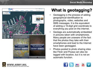
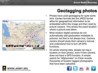
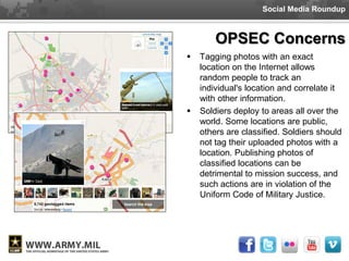
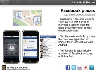
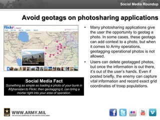
This document discusses the risks of geotagging photos and using location-based social media when one is in the military. It notes that geotagged photos and check-ins on apps like Foursquare can reveal sensitive information like locations of military bases or troop movements. The document provides tips for protecting operational security, such as turning off GPS metadata in photos and location services on phones when one is engaged in military operations. Revealing location data could damage missions and endanger lives.
This document discusses how location data and geolocation technologies can inform library strategies. It defines key terms like geolocation, GPS, GIS, and geotagging. It explores how libraries can use location data to better understand user behaviors, target services, and analyze traffic patterns. Location-based social media and applications are also examined as opportunities to engage users beyond physical library walls. The document advocates for libraries to leverage location data to improve user experiences, outreach, and strategic decision making.
2012 May Agency : Insight Presentation: "How SoLoMo is Empowering Consumers, ...iMedia Connection
This document discusses how SoLoMo (social, location, and mobile) technologies are connecting consumers and brands. It describes how certain mobile sites have gained users rapidly and generate significant referral traffic. SoLoMo utilizes the six elements of mobile devices, broadband, apps, sensors, the internet, and cloud computing combined with the six elements of location, social sharing and networks to provide personalized, engaging, and enabling experiences. This empowering of consumers through SoLoMo is transforming shopping and disrupting advertising.
The document discusses new media and social media. It defines new media as on-demand access to content from any device, as well as interactive feedback and community formation around media. Social media includes technologies used for interactive communication among people and organizations. Examples of social networks mentioned include Facebook and MySpace. The rest of the document discusses how social media and technology have evolved together, with things like mobile phones and responsive design changing how people engage with social platforms.
The document discusses how social, location, and mobile (SoLoMo) technologies are connecting consumers and brands. It notes that a major social media site reached 10 million U.S. monthly visitors faster than any other independent site, and is generating more referral traffic than YouTube, Google+, and LinkedIn combined. The document then outlines the six elements that enable SoLoMo experiences: devices, broadband, apps, sensors, the internet, and cloud computing. It provides examples of how location data and social connections can enhance experiences. Finally, it discusses trends in hyperlocal audiences, micro-location, and ambient analytics that will shape the future of SoLoMo.
The document discusses NASA's strategies for creating effective social media presences. It explains that NASA started with flagship accounts on platforms like Twitter and Facebook in the late 2000s and grew audiences into the millions by consistently sharing great content. NASA also created niche accounts focused on specific missions and programs. The document outlines other engagement tactics NASA uses like social media events, experts interviews, contests and collaborating with brand ambassadors to spread their messages. It argues this approach helps NASA connect with non-traditional audiences and move followers from passive consumers to active advocates and collaborators.
This document discusses the topics of geolocation, geotagging, and how location data is used across various technologies and platforms. It provides definitions for terms like geolocation, GPS, GIS, geo-IP, and geotagging. It also summarizes how location data is used on social media platforms like Facebook, Flickr, and Twitter. Examples are given of location-based apps like Foursquare and Gowalla. The document suggests ways libraries can utilize location data, such as for targeted advertising, market research, and geo-authentication. Overall, the summary discusses emerging technologies related to geolocation and how location information is captured and applied in various contexts.
The document discusses NASA's social media strategy and evolution. It notes that NASA has over 467 social media accounts managed by 2 full-time employees, 10 center social media leads, and 11 part-time leads. The accounts have evolved organically over time into a structured "solar system" model with flagship accounts at the center and more specialized niche accounts. The strategy harnesses the power of flagship accounts to reach broad audiences while allowing specialized accounts to engage specific interest groups. This approach has helped NASA achieve milestones like the first tweet from space in 2009.
The attached PTS Plain Talk gives Sailor the breakdown of PTS and address the different factor they can control. It is highly recommended that this be printed and distributed to all Sailors, and include this as part of CDB process. This checklist puts the responsibility on the Sailor to get educated on all their options, it starts at check-in and goes through entire PTS process (to include the algorithm) .
The document summarizes the role of Command Career Counselors in assisting sailors through the transition process. It outlines that Counselors should initiate pre-separation counseling and the Individual Transition Plan (ITP) 9-12 months from separation. Sailors are required to complete the Transition GPS curriculum, ITP checklist, and CAPSTONE event. Counselors verify sailors have the required documentation to attend Transition GPS and provide additional counseling as requested. The ITP and use of resources like Transition GPS help sailors develop career plans and transition successfully to civilian life.
This document provides an overview of military and government educational benefits available to service members and veterans. It discusses the original GI Bill signed in 1944 which provided education, home loans, and unemployment benefits to WWII veterans. Over 7.8 million veterans participated in education programs and 2.4 million received home loans. The GI Bill transformed the US by increasing wealth and home ownership. It established that education is the best investment. Today's Montgomery GI Bill continues this legacy and provides billions for veterans' education and training. In addition to GI Bill benefits, veterans have access to huge pools of other scholarship money. The document emphasizes that understanding how to pursue these opportunities requires knowing how the "scholarship game" is played and examines common misconceptions about
This document establishes policy and procedures for determining eligibility of regular and reserve military personnel for separation pay upon involuntary discharge from active duty. It outlines the criteria for full or half separation pay, including requirements for years of active service, characterization of separation, reason for separation, and agreement to serve in the ready reserve. It also provides details on computing active service time and the amounts of separation pay.
Perform To Serve (PTS) is a long term force shaping tool that aids in leveling out manning between overmanned and undermanned ratings while managing the quality of reenlistment applicants by controlling the authority for reenlistment.
Sailors must have an approved PTS reservation prior to reenlisting, receiving SRB, or negotiating orders.
The document provides an overview of changes and enhancements made in the Career Management System/Interactive Detailing MU1B-4 release delivered in April 2010. Key updates include masking sailors' social security numbers, adding special program flags, modifying physical fitness assessment flags, and including gender specific gates. Help resources and relevant NAVADMIN messages are also outlined.
Cybercasing and privacy implications of geo tagging Prayukth K V
This article aims to raise awareness of a rapidly emerging
privacy threat that we term cybercasing: using geo-tagged information available online to mount real-world attacks
This document discusses geolocation technology and its applications. It begins with definitions of key terms like geolocation, GPS, satellites, waypoints and geocaching. It then demonstrates how to use a GPS receiver to find locations, mark waypoints and view coordinate data. The document discusses using geotagged photos and sharing locations online. It emphasizes that geolocation provides new ways to organize and search information, with implications for research and learning like observing patterns and gaining deeper insights when location data is incorporated.
This document discusses operational security (OPSEC) considerations for using social media. It provides tips for safe social media use such as being careful about what personal information is posted, using privacy settings, disabling geotagging, and being aware that even seemingly harmless posts can potentially put soldiers, families and missions at risk if they provide too many details to adversaries. Specific concerns are outlined for units, families, family readiness groups and children using social media. The document emphasizes that OPSEC should always be the top priority for anyone in the Army community using social media.
Location-based social networks allow users to share their location with friends through mobile apps. Popular networks like Foursquare and Gowalla let users "check in" to locations and earn rewards. These networks aim to have a large user base to attract businesses interested in marketing to customers based on their locations. However, to be successful long-term, networks need to focus on what motivates users to share beyond just checking in to locations.
Geo-social networks are location-based social media applications that use GPS or other location methods to identify where a user is located and share that information with friends or communities. Users can check-in to different locations using their mobile phones or devices. This allows friends to see where each other have been, like parks, bars, or restaurants. Popular geo-social networks include Foursquare, Gowalla, Facebook Places, and others. These applications aim to reward users for exploring locations in their cities with badges, coupons, or other perks through a game-like experience.
This document discusses mobile strategies and current mobile usage statistics. It notes that by 2013, over half of all mobile phone use will be smartphones and mobile devices will surpass PCs as the most common web access tool. Examples of mobile optimized websites, text messaging for donations, location based services like Foursquare, mobile learning apps, and using QR codes to connect physical materials to online content are provided. Checklists for organizations to evaluate their mobile presence and educators to consider mobile learning are included at the end.
Mobile Web vs. Native Apps | Design4MobileJason Grigsby
This document provides an overview of a presentation on native mobile apps versus mobile web apps. It includes slides on why developers were fighting over the two approaches, Apple's announcement allowing third-party apps on the iPhone, and the surprise success of the iPhone App Store. It also discusses factors that contributed to the App Store's success like its openness, revenue split, and fewer restrictions compared to mobile carriers. The document debates questions around whether apps create platform lock-in, if app stores are essential to a platform's success, and challenges of developing for multiple mobile platforms. It suggests that HTML5 and WebKit may become the dominant mobile platform.
This document discusses social networking and privacy concerns. It addresses what information people share on social media, their responsibility to their networks, using location-based apps, and risks like smishing. It provides tips for mobile security like securing WiFi connections, checking app creators and numbers, avoiding storing sensitive info on phones, understanding who can see your location from geotagging, and adjusting privacy settings for location-based apps. The document advocates considering one's digital footprint and privacy when using social media.
Sixth Sense is a wearable gestural interface developed by Pranav Mistry that augments the physical world with digital information. It comprises a camera, projector, mirror, and smartphone. The camera captures gestures and objects, sending the data to the smartphone for processing. The projector then reflects processed information onto surfaces using the mirror. Applications include making calls, getting maps, checking the time, and accessing information about objects by recognizing images or markers. Sixth Sense bridges the gap between physical and digital worlds by allowing natural hand gestures to interact with projected information.
This document summarizes a term paper on location-based digital badges integrated into portable devices. It proposes combining GPS, social media, personal info, and local data to create an "always-on" location sensor that broadcasts identity and schedule. It reviews current location services and suggests improvements like augmented GPS and indoor RFID tracking. The paper envisions a digital badge app that intelligently monitors usage patterns and location to provide personalized updates and suggestions to users.
Workshop 5 -Mobile Strategy, Digital Photography, and Learning Culmination (PPT)madhavi2011
This two-day workshop focused on mobile strategy, digital photography, and learning culmination for NGOs. Day 1 covered an introduction to mobile tactics and basics of digital photography. Participants learned how to capture photos and gain tips for mobile strategy. Day 2 was for sharing lessons learned, including a video assignment. Attendees discussed social media strategy plans and had their remaining questions addressed. They also shared a social media impact story. The goal overall was to help NGOs integrate mobile technologies and digital photography into their communication strategies.
The Future is Now - PopTech Marketing Event March 8thAmber Case
Today we’re all carrying around not phones in our pockets, but sensors. These sensors are capable of processing information, and taking pictures, as well as knowing where we are and how fast we’re moving, These sensors used to cost thousands of dollars and weigh tens of pounds. Now they’re available to everyone.
This presentation will cover a history of augmented reality and mobile connectivity, as well as where the market is today and how it can be leveraged to deliver groundbreaking interactive campaigns and engaging media. We'll dive into some of the augmented reality campaigns, pros and cons of AR and QR codes, and a series of platforms on which you can make your own location based augmented reality applications. Also discussed is http://geoloqi.com, a service and platform for building location-aware applications.
The document provides information about EXIF data embedded in digital photographs and recommendations for removing this metadata to protect privacy. It discusses how EXIF tags can reveal private location information, timestamps, camera details, and image descriptions. The summary recommends disabling EXIF capture on smartphones, removing existing EXIF data before sharing photos, and using privacy settings to limit audiences since content alone can identify people and locations even without EXIF data.
Truly Moble Applications: Location, Media Capture, and Social Connectivitybentley79
A talk I gave at an Interaction Design class at the IIT Institute of Design. Talks about unique aspect of mobile computing including location, media capture, and social connectivity. Uses the ZoneTag application as an example of a mobile app that uses all three.
PANORAMIO -A MOBILE APPLICATION BASED ON ANDROIDcscpconf
Panoramio is a mobile application which allows the users to find pictures of interesting places
with a radar to guide you to them, using GPS. Since the use of smart phones is gaining interest
in people, panoramio was implemented as a smart phone application using Google’s Android
operating system.The application starts by showing a custom map view using mobile maps. The
user can pan and zoom the map to select a location. Once a search location has been selected
the user taps on a location and the application starts loading all the thumbnails of pictures of all the interesting places taken in that area. By tapping on any thumbnail, information about the particular picture will be displayed. From here the user can view other photos taken by the same user or share the page. And even we can upload these new places. Show your favorite places to the world. Upload your photos to Panoramio. Upload your geolocated photos directly from the Gallery to your Panoramio account which, has following Features includes, Adds a new sharing option for any photo either taken by the built-in camera, or chosen from the gallery, Grab location from EXIF,Allow manual correction of the location.
Lisa Colton presents on mobile trends to the Social Media Boot Camp for Educators. Mobile websites, Jewish apps, location based services, QR codes and more.
This document discusses augmented reality (AR) and virtual reality (VR). It defines AR as combining real and computer generated images in real time by superimposing digital images onto the real world. VR is described as a computer generated 3D space that projects the user into through a stereoscopic headset. The document outlines how AR and VR work using marker-based and location-based tracking, as well as head tracking, eye tracking and motion tracking for VR. Challenges, goals, applications and the differences between AR and VR are examined. The conclusion states that while AR is still developing, the ultimate goal is for virtual objects to be indistinguishable from the real world.
USC Annenberg Journalism Director's Forum - Future of Mobile News and Journal...THE SWARM
This document discusses the current state and future predictions of mobile technology and its impact on news organizations. It explores how mobile is changing how news is distributed through new channels like messaging and social media. It also examines opportunities for newsgathering using data and user-generated content. The document predicts that in the future, mobile web apps may challenge app stores, multi-screen experiences will become more common, games will be used to drive user behavior and collect valuable data, location-based checking in could create new competitors to companies like Google and Facebook, and ambient computing using location awareness will become normal.
Organizations such as Coast Guard, Facebook, Amazon, Department of Defense has a career service provider that helps members make good career decisions and transition enhancing morale and focus on doing a better job in their current position. A lecture and proposal to Coast Guard.
Dr. Astro talks about the importance of Personal wellness and discusses the holistic approach in career counseling in making good personal decisions in life.
Humans can often determine a lot about other people just by looking at their faces and bodies. Subtle cues like facial expressions, posture, and clothing choices unconsciously provide clues about personality traits, emotions, intentions, social status, and more. While quick judgments based on appearance alone can be inaccurate, research shows that people tend to form initial impressions about others based primarily on visual information.
This document discusses cultural intelligence (CQ) and how it relates to age and generational culture. It provides links to resources on defining CQ and the pros and cons of diversity as well as a blog post about technologists and CQ, suggesting CQ is important for understanding differences between age groups and cultures.
Tony Astro has experience in career counseling, human resources, business ownership, and diversity training. He has traveled to over 30 countries and volunteers in his community. The document discusses how the Internet of Things will impact customers, innovation, competitors, work styles, and cultural intelligence. It suggests using social media, video, blogs, mobile phones, networking, and other online tools to connect, create, celebrate, collaborate, contact, and communicate in this new digital landscape.
This document contains announcements and advertisements for a series of talks called "FusionTalk" held bi-monthly that last 15 minutes each and cover topics related to business, career, and culture. The talks are free for members of ABAHR and open to all, and are sponsored by various groups and individuals. They are held at different locations in Virginia Beach.
1. Here is something you already know. People like to get free stuff. What kind of people? well, new prospects who need to become aware of your company or services loyal customers who deserve to be appreciated and employees who have gone the extra mile.
2. How about others? Well, trade show visitors love advertising specialties and so do the more than 6 out of 10 people who enjoy receiving their mail every day
3. In fact, the direct marketing association says you can double your response rates with lumpy envelopes containing small items because they make people curious and like we said everyone likes free stuff.
4. Here at Mvoss Creation we have access to thousands of promotional products to fit any budget or company. Better still we can show you how to save time and money by helping you match the right things to the right people for the right occasions that’s what we call flexibility
5. But are logoed items really effective? you bet. Logoed items can promote your company much longer than most other forms of advertising. The advertising specialty institute says promotional items are kept for an average of seven months and more than 60% get passed along to someone else plus they’re memorable - nearly 90 percent of recipients are able to recall the company name on their promotional products.
6. Best of all they’re affordable to business of all sizes delivering a fantastic return on investment of course to get these great results you need to find a great local product
7. Contact Mvoss Creation about totes, backpacks and caps or functional desk accessories, calendars, USB drives and more.
8. There truly is something for everyone Mvoss Creation your convenient one stop source for practical cost effective marketing and print solutions with the power of promotional items to bring your brand to life and Market your Visuals to Optimize your Social & Services of your company, events or your brand contact Mvoss Creation today.
Military & Veteran Career Issues
What challenges and issues do I foresee facing the veteran and military affiliated student population? What role would CHIEFPRENEUR play as the coordinator?
10 minutes presentation
Tony Astro gave a 10 minute briefing on 3 undergraduate degrees: Bachelor of Science in Business, Bachelor of Arts in Christian Ministry, and Bachelor of Arts in Animation. He described the career opportunities, program requirements, and contact information for each degree. The Business degree focuses on principles, theory, and real-world experience to prepare students for careers in fields like marketing, human resources, and accounting. The Christian Ministry degree teaches the Bible, communication, and discipleship to prepare students for church roles and nonprofit work. The Animation degree utilizes advanced technology and software to train students for careers in areas such as game design, animation, and graphic design.
Eligibility Communicating with the board Pre board Membership Quotas Tools of the board Not Presented to Board Members What the Board Considers Board Process Overview Post Board Process Special boards Common Issues/FAQs/MythsEnl advancement board brief for pers 803 webpage (feb 10 2015)
This is directed at all of my Reserve Component Chief Petty Officer shipmates:
“Do you want to take COMMAND? Can you be entrusted to stand tall under pressure? If you are a Chief then the answer must be a resounding “Aye, Aye!” Would you like to drill/serve your country past the maximum 30 years of TIS allowed for enlisted personnel? Do you have what it takes to wear "eagles" on your collar or be a CWO5? Would you like to increase your retirement pay by 50% or even 100%?
If you are an E-7 through E-9 with the desire to reach for one of the most demanding and satisfying positions in the Navy, the Limited Duty Officer or Chief Warrant Officer Commissioning Program may be for you.
The RC LDO/CWO program is actively seeking candidates with the “right stuff”. The RC CWO program is in particular need of support from the CPO mess. We are approximately 50% manned in our RC CWO inventory and we are losing folks almost as fast as we are “making” them. The RC LDO situation is a bit better, but not by much. So the fleet has an incentive to get as many highly qualified candidates into those billets as possible.
If you are a Reserve Component Chief Petty Officer and are interested in the RC LDO/CWO program, then now is the time to take the next step.
The following designator/career fields are OPEN:
623X (LDO SUB REPAIR)
626X (LDO SUB ORDNANCE)
628X (LDO SUB ELEX)
629X (LDO SUB COMMS)
633X (LDO AV MAINT)
641X (LDO ADMIN)
642X (LDO INFO PRO)
645X (LDO INTEL)
649X (LDO SECURITY)
653X (LDO CEC)
711X (SURF DECK CWO)
712X (SURF OPS CWO)
713X (SURF REP CWO)
715X (SEAL CWO)
716X (SURF ORD CWO)
717X (SWCC CWO)
742X (INFO TECH CWO)
744X (INFO WARFARE CWO)
745X (INTEL CWO)
Any interested applicants should take a look at the attached program flyer for more information. Anyone that does NOT already have an RC LDO/CWO mentor to assist with application preparation and the interview appraisal process should immediately contact our Recruiting Action Officer for assistance: CWO2 Richard Townsend: richard.townsend@navy.mil
Applications are due NLT 01OCT2015, so time is running short. The fleet needs you now. I am "living proof" of what the program offers. It worked for me and it can work for you too. Please pass the word.
R,
CAPT Jim Elizares ("commissioned CPO", Anchors earned in 1985)
RC LDO/CWO Community Leader “Mustangs Earn it Everyday”
jameselizares@yahoo.com
james.f.elizares@navy.mil
*** No College Required: Active Duty Commissioning or Officers Program: LDO/CWO *** If you are an E-7 through E-9 with the desire to reach for one of the most demanding and satisfying positions in the Navy, the Limited Duty Officer or Chief Warrant Officer Commissioning Program may be for you.http://www.npc.navy.mil/…/LDO%20and%20CWO%20Recruit%20Your%…
The document discusses eligibility requirements and benefits of the Post-9/11 GI Bill. Key points include:
- To receive full benefits, members must have at least 36 months of qualifying active duty service. Lesser amounts provide reduced benefits.
- Benefits include payment of tuition and fees at public and private colleges, books and supplies stipends, housing allowances, and licensing exam reimbursement.
- The GI Bill can now be transferred to dependents if the service member commits to additional years of military service.
This document provides instructions for requesting access to the CIMS system. It outlines the steps to open an internet browser and navigate to the NSIPS login page, where a CAC is required for authentication. It describes selecting "CIMS Departmental/Divisional Career Counselor" and filling out fields with name, email, phone and justification. Requestors are also instructed to select the appropriate CIMS UIC and notify a CCC once access is approved so sailors can be assigned.
The Career Tools Afloat (CTA) page replaced "NKO at Sea" and provides access to Navy eLearning (NeL) Afloat, Electronic Training Jacket (ETJ) Afloat, and FLTMPS Afloat. When Internet is available, it also provides links to systems ashore.
This document summarizes updates from a September 2014 Navy College newsletter. It outlines changes to Navy Tuition Assistance (TA) policy in NAVADMIN 190/14, including allowing TA use in the first year and reimbursement requirements for failing grades. It also provides tips for TA success, information on the Department of Defense Memorandum of Understanding (MOU) with education providers, and details the new Postsecondary Education Complaint System. Contact information is given for local Navy College Offices and the Virtual Education Center.
This document provides an overview of the Exceptional Family Member Program (EFMP) for command points of contact. It discusses the history and goals of EFMP, common myths about the program, benefits of enrollment, eligibility criteria, the enrollment process, categories of enrollment, and responsibilities of command EFMP points of contact. Contact information is provided for EFMP liaisons and medical coordinators who can assist with the program.
More from Tony Astro - Veteran Counselor & Entrepreneur (20)
High performance Serverless Java on AWS- GoTo Amsterdam 2024Vadym Kazulkin
Java is for many years one of the most popular programming languages, but it used to have hard times in the Serverless community. Java is known for its high cold start times and high memory footprint, comparing to other programming languages like Node.js and Python. In this talk I'll look at the general best practices and techniques we can use to decrease memory consumption, cold start times for Java Serverless development on AWS including GraalVM (Native Image) and AWS own offering SnapStart based on Firecracker microVM snapshot and restore and CRaC (Coordinated Restore at Checkpoint) runtime hooks. I'll also provide a lot of benchmarking on Lambda functions trying out various deployment package sizes, Lambda memory settings, Java compilation options and HTTP (a)synchronous clients and measure their impact on cold and warm start times.
Northern Engraving | Modern Metal Trim, Nameplates and Appliance PanelsNorthern Engraving
What began over 115 years ago as a supplier of precision gauges to the automotive industry has evolved into being an industry leader in the manufacture of product branding, automotive cockpit trim and decorative appliance trim. Value-added services include in-house Design, Engineering, Program Management, Test Lab and Tool Shops.
AppSec PNW: Android and iOS Application Security with MobSFAjin Abraham
Mobile Security Framework - MobSF is a free and open source automated mobile application security testing environment designed to help security engineers, researchers, developers, and penetration testers to identify security vulnerabilities, malicious behaviours and privacy concerns in mobile applications using static and dynamic analysis. It supports all the popular mobile application binaries and source code formats built for Android and iOS devices. In addition to automated security assessment, it also offers an interactive testing environment to build and execute scenario based test/fuzz cases against the application.
This talk covers:
Using MobSF for static analysis of mobile applications.
Interactive dynamic security assessment of Android and iOS applications.
Solving Mobile app CTF challenges.
Reverse engineering and runtime analysis of Mobile malware.
How to shift left and integrate MobSF/mobsfscan SAST and DAST in your build pipeline.
Fueling AI with Great Data with Airbyte WebinarZilliz
This talk will focus on how to collect data from a variety of sources, leveraging this data for RAG and other GenAI use cases, and finally charting your course to productionalization.
inQuba Webinar Mastering Customer Journey Management with Dr Graham HillLizaNolte
HERE IS YOUR WEBINAR CONTENT! 'Mastering Customer Journey Management with Dr. Graham Hill'. We hope you find the webinar recording both insightful and enjoyable.
In this webinar, we explored essential aspects of Customer Journey Management and personalization. Here’s a summary of the key insights and topics discussed:
Key Takeaways:
Understanding the Customer Journey: Dr. Hill emphasized the importance of mapping and understanding the complete customer journey to identify touchpoints and opportunities for improvement.
Personalization Strategies: We discussed how to leverage data and insights to create personalized experiences that resonate with customers.
Technology Integration: Insights were shared on how inQuba’s advanced technology can streamline customer interactions and drive operational efficiency.
Discover top-tier mobile app development services, offering innovative solutions for iOS and Android. Enhance your business with custom, user-friendly mobile applications.
Freshworks Rethinks NoSQL for Rapid Scaling & Cost-EfficiencyScyllaDB
Freshworks creates AI-boosted business software that helps employees work more efficiently and effectively. Managing data across multiple RDBMS and NoSQL databases was already a challenge at their current scale. To prepare for 10X growth, they knew it was time to rethink their database strategy. Learn how they architected a solution that would simplify scaling while keeping costs under control.
"Choosing proper type of scaling", Olena SyrotaFwdays
Imagine an IoT processing system that is already quite mature and production-ready and for which client coverage is growing and scaling and performance aspects are life and death questions. The system has Redis, MongoDB, and stream processing based on ksqldb. In this talk, firstly, we will analyze scaling approaches and then select the proper ones for our system.
Your One-Stop Shop for Python Success: Top 10 US Python Development Providersakankshawande
Simplify your search for a reliable Python development partner! This list presents the top 10 trusted US providers offering comprehensive Python development services, ensuring your project's success from conception to completion.
This talk will cover ScyllaDB Architecture from the cluster-level view and zoom in on data distribution and internal node architecture. In the process, we will learn the secret sauce used to get ScyllaDB's high availability and superior performance. We will also touch on the upcoming changes to ScyllaDB architecture, moving to strongly consistent metadata and tablets.
[OReilly Superstream] Occupy the Space: A grassroots guide to engineering (an...Jason Yip
The typical problem in product engineering is not bad strategy, so much as “no strategy”. This leads to confusion, lack of motivation, and incoherent action. The next time you look for a strategy and find an empty space, instead of waiting for it to be filled, I will show you how to fill it in yourself. If you’re wrong, it forces a correction. If you’re right, it helps create focus. I’ll share how I’ve approached this in the past, both what works and lessons for what didn’t work so well.
Monitoring and Managing Anomaly Detection on OpenShift.pdfTosin Akinosho
Monitoring and Managing Anomaly Detection on OpenShift
Overview
Dive into the world of anomaly detection on edge devices with our comprehensive hands-on tutorial. This SlideShare presentation will guide you through the entire process, from data collection and model training to edge deployment and real-time monitoring. Perfect for those looking to implement robust anomaly detection systems on resource-constrained IoT/edge devices.
Key Topics Covered
1. Introduction to Anomaly Detection
- Understand the fundamentals of anomaly detection and its importance in identifying unusual behavior or failures in systems.
2. Understanding Edge (IoT)
- Learn about edge computing and IoT, and how they enable real-time data processing and decision-making at the source.
3. What is ArgoCD?
- Discover ArgoCD, a declarative, GitOps continuous delivery tool for Kubernetes, and its role in deploying applications on edge devices.
4. Deployment Using ArgoCD for Edge Devices
- Step-by-step guide on deploying anomaly detection models on edge devices using ArgoCD.
5. Introduction to Apache Kafka and S3
- Explore Apache Kafka for real-time data streaming and Amazon S3 for scalable storage solutions.
6. Viewing Kafka Messages in the Data Lake
- Learn how to view and analyze Kafka messages stored in a data lake for better insights.
7. What is Prometheus?
- Get to know Prometheus, an open-source monitoring and alerting toolkit, and its application in monitoring edge devices.
8. Monitoring Application Metrics with Prometheus
- Detailed instructions on setting up Prometheus to monitor the performance and health of your anomaly detection system.
9. What is Camel K?
- Introduction to Camel K, a lightweight integration framework built on Apache Camel, designed for Kubernetes.
10. Configuring Camel K Integrations for Data Pipelines
- Learn how to configure Camel K for seamless data pipeline integrations in your anomaly detection workflow.
11. What is a Jupyter Notebook?
- Overview of Jupyter Notebooks, an open-source web application for creating and sharing documents with live code, equations, visualizations, and narrative text.
12. Jupyter Notebooks with Code Examples
- Hands-on examples and code snippets in Jupyter Notebooks to help you implement and test anomaly detection models.
"Frontline Battles with DDoS: Best practices and Lessons Learned", Igor IvaniukFwdays
At this talk we will discuss DDoS protection tools and best practices, discuss network architectures and what AWS has to offer. Also, we will look into one of the largest DDoS attacks on Ukrainian infrastructure that happened in February 2022. We'll see, what techniques helped to keep the web resources available for Ukrainians and how AWS improved DDoS protection for all customers based on Ukraine experience
Main news related to the CCS TSI 2023 (2023/1695)Jakub Marek
An English 🇬🇧 translation of a presentation to the speech I gave about the main changes brought by CCS TSI 2023 at the biggest Czech conference on Communications and signalling systems on Railways, which was held in Clarion Hotel Olomouc from 7th to 9th November 2023 (konferenceszt.cz). Attended by around 500 participants and 200 on-line followers.
The original Czech 🇨🇿 version of the presentation can be found here: https://www.slideshare.net/slideshow/hlavni-novinky-souvisejici-s-ccs-tsi-2023-2023-1695/269688092 .
The videorecording (in Czech) from the presentation is available here: https://youtu.be/WzjJWm4IyPk?si=SImb06tuXGb30BEH .
What is an RPA CoE? Session 1 – CoE VisionDianaGray10
In the first session, we will review the organization's vision and how this has an impact on the COE Structure.
Topics covered:
• The role of a steering committee
• How do the organization’s priorities determine CoE Structure?
Speaker:
Chris Bolin, Senior Intelligent Automation Architect Anika Systems
1. Social Media Roundup
Geotags and Location-
Based Social Networking
Applications, OPSEC
and protecting unit safety
2. Social Media Roundup
Introduction
• In August of 2010, Adam Savage, of
“MythBusters,” took a photo of his
vehicle using his smartphone. He then
posted the photo to his Twitter account
including the phrase “off to work.”
• Since the photo was taken by his
smartphone, the image contained
metadata reveling the exact
geographical location the photo was
taken.
• So by simply taking and posting a photo,
Savage revealed the exact location of
his home, the vehicle he drives and the
time he leaves for work.
Read the full story here: http://nyti.ms/917hRh
3. Social Media Roundup
Introduction
The following was published in
Wired Magazine in 2009
• “I ran a little experiment. On a sunny Saturday, I
spotted a woman in Golden Gate Park taking a
photo with a 3G iPhone. Because iPhones embed
geodata into photos that users upload to Flickr or
Picasa, iPhone shots can be automatically placed
on a map. At home I searched the Flickr map, and
score—a shot from today. I clicked through to the
user’s photostream and determined it was the
woman I had seen earlier. After adjusting the
settings so that only her shots appeared on the
map, I saw a cluster of images in one location.
Clicking on them revealed photos of an apartment
Read the full story here: interior—a bedroom, a kitchen, a filthy living room.
http://bit.ly/bJqYmm
Now I know where she lives.”
4. Social Media Roundup
Introduction
• As the stories above indicate, privacy
and security aren’t what they used to
be. With advancements in
technology, enhanced GPS
capabilities and smartphones with
built-in GPS, managing privacy and
security is a fulltime job.
• The Army is always working to
protect itself against security
breaches, but with new technologies
come new risks. Today, more than
ever, it is vitally important that Army
leaders, Soldiers and Army civilians
understand what kind of data they
are broadcasting and what they can
do to protect themselves and their
families.
5. Social Media Roundup
What is geotagging?
• Geotagging is the process of adding
geographical identification to
photographs, video, websites and
SMS messages. It is the equivalent
of adding a 10-digit grid coordinate to
everything you post on the internet.
• Geotags are automatically embedded
in pictures taken with smartphones.
Many people are unaware of the fact
that the photos they take with their
smartphones and load to the Internet
have been geotagged.
• Photos posted to photo sharing sites
like Flickr and Picasa can also be
tagged with location, but it is not an
automatic function.
6. Social Media Roundup
Geotagging photos
• Photos have used geotagging for quite some
time. Certain formats like the JPEG format
allow for geographical information to be
embedded within the image and then read by
picture viewers. This shows the exact location
where a picture was taken.
• Most modern digital cameras do not
automatically add geolocation metadata to
pictures, but that is not always true. Camera
owners should study their camera’s manual
and understand how to turn off GPS
functions.
• On photo sharing sites, people can tag a
location on their photos, even if their camera
does not have a GPS function. A simple
search for “Afghanistan” on Flickr reveals
thousands of location tagged photographs
that have been uploaded.
7. Social Media Roundup
OPSEC Concerns
Tagging photos with an exact
location on the Internet allows
random people to track an
individual's location and correlate it
with other information.
Soldiers deploy to areas all over the
world. Some locations are public,
others are classified. Soldiers should
not tag their uploaded photos with a
location. Publishing photos of
classified locations can be
detrimental to mission success, and
such actions are in violation of the
Uniform Code of Military Justice.
9. Social Media Roundup
Location-based Social Networking
Location-based social networking is
quickly growing in popularity. A variety of
applications are capitalizing on users’
desire to broadcast their geographic
location.
Most location-based social networking
applications focus on “checking in” at
various locations to earn points, badges,
discounts and other geo-related awards.
The increased popularity of these
applications is changing the way we as a
digital culture view security and privacy on
an individual level. These changes in
perception are also creating OPSEC
concerns on an Army level.
10. Social Media Roundup
foursquare
http://foursquare.com/
Foursquare is a location-based social networking
website for mobile devices. Users “check-in” at
various places using a mobile website. They are
then awarded points and sometimes “badges.”
Users of foursquare use the service to share their
location with friends, meet new people and get
coupons. Users can also connect and publish their
“check ins” to Facebook and Twitter. If someone is
not a friend on foursquare they can still track your
whereabouts through Facebook.
Foursquare has over 4 million users.
Foursquare currently has iPhone, Android,
webOS, Windows Phone 7 and BlackBerry
applications.
11. Social Media Roundup
Facebook places
http://www.facebook.com/places/
• Facebook’s “Places” is similar to
Foursquare in that it gives an
individual’s location when the
users posts information using a
mobile application.
• This feature is available by using
the Facebook application for
iPhone, touch.facebook.com and
Android.
• This function is automatically
active on all Facebook accounts
until disabled.
12. Social Media Roundup
Gowalla
http://gowalla.com/
• Gowalla is another location-
based social networking
application that functions
much like Foursquare and
Facebook Places.
• Users can build a Passport
which includes a collection of
stamps from the places users
have been.
• Gowalla users can also post
photos and submit tips at
various locations.
13. Social Media Roundup
SCVNGR
http://www.scvngr.com/
• SCVNGR is a location-based social networking application that takes “checking
in” a step further by allowing companies, educational institutions and organizations
to build challenges inside the platform.
• Users are encouraged to complete the challenges in order to earn points, badges
or real-life discounts and coupons.
14. Social Media Roundup
Why are these applications potentially dangerous?
Establishes patterns: Services like
MotionX (on right) and other location-
based social networking applications
allow strangers to track your movements
every day. If they watch someone long
enough they will know exactly when and
where to find that person on any given
day.
Exposes places of duty and home: By
tracking movements and aggregating
information, strangers can determine
where someone lives and works.
Identifies location of Army personnel:
If certain applications are used daily
around Army populations, an enemy can
determine potential targets.
15. Social Media Roundup
OPSEC Concerns
The main function of location-
based social networking
applications is to broadcast a
user’s specific location. Exposing
Soldier and unit locations gives
the enemy the upper hand.
One Soldier exposing his/her
location can affect the entire
mission.
Deployed Soldiers, or Soldiers
conducting operations in
classified areas should not use
location-based social networking
services. These services will
bring the enemy right to the
Army’s doorstep.
17. Social Media Roundup
Avoid geotags on photosharing applications
• Many photosharing applications give
the user the opportunity to geotag a
photo. In some cases, these geotags
can add context to a photo, but when
it comes to Army operations,
geotagging operational photos is not
allowed.
• Users can delete geotagged photos,
but once the information is out there,
it’s out of the user’s hands. Even if
posted briefly, the enemy can capture
Social Media Fact vital information and record exact grid
Something as simple as loading a photo of your bunk in coordinates of troop populations.
Afghanistan to Flickr, then geotagging it, can bring a
mortar right into your area of operation.
18. Social Media Roundup
Turn off GPS function on phones
• One of the simplest ways to
avoid displaying too much
information is to disable the
geotagging function on
smartphones.
• Since most smartphones
automatically display
geographical information, it
takes a little more effort on the
user’s part to protect their
privacy.
• It’s important that all users
understand their specific
systems and make efforts to
turn off their phone’s
geotagging function.
19. Social Media Roundup
Summary
• Geotagging photos and using location-based social networking applications is
growing in popularity, but in certain situations, exposing specific geographical
location can be devastating to Army operations.
• Soldiers should never tag photos with geographical location when loading to
photo sharing sites like Flickr and Picasa.
• Soldiers should not use location-based social networking applications when
deployed, at training or while on duty at locations where presenting exact grid
coordinates could damage Army operations.
• It is advised that while Soldiers are engaged in Army operations, they should turn
off the GPS function of their smartphones. Failure to do so could result in damage
to the mission and even put families at risk.
• Users deciding to utilize location-based social networking sites should be aware of
the default settings for the services and devises they use. It is recommend that
the users customize settings to be mindful of OPSEC and success of Army
operations.
20. Social Media Roundup
Contact information
Have questions? Please feel free to
reach out to us at the Online and
Social Media Division
Email:
Ocpa.osmd@us.army.mil
OFFICE OF THE CHIEF OF PUBLIC AFFAIRS
PENTAGON
20