Download as PDF, PPTX
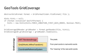
![Jiffle Example
nir = src[7];
vir = src[3];
dest = (nir-vir)/(nir+vir);
Sentinel 2 dataset, 13
bands
Jiffle script On the fly NDVI index display](https://image.slidesharecdn.com/stateofjai-181101011057/85/Java-Image-Processing-for-Geospatial-Community-11-320.jpg)
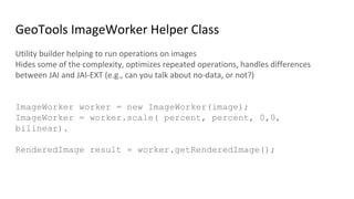
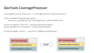


![JAI ParameterBlock Example
FileSeekableStream stream = new FileSeekableStream(args[0]);
RenderedOp image1 = JAI.create(“stream”, stream);
ParameterBlock params = new ParameterBlock();
params.addSource(image1);
params.add(2.0F); // x scale factor
params.add(2.0F); // y scale factor
params.add(0.0F); // x translate
params.add(0.0F); // y translate
params.add(Interpolation.INTERP_BILINEAR);
/* Create an operator to scale image1. */
RenderedOp image2 = JAI.create(“scale”, params, hints);](https://image.slidesharecdn.com/stateofjai-181101011057/85/Java-Image-Processing-for-Geospatial-Community-42-320.jpg)
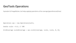
![FileSeekableStream stream = new FileSeekableStream(args[0]);
RenderedOp image1 = JAI.create(“stream”, stream);
RenderedOp image2 =
ScaleDescriptor.create(image1,2.0F, 2.0F, 0.0F, 0.0F,Interpolate.INTERP_BILINEAR, hints);
JAI Descriptor Example](https://image.slidesharecdn.com/stateofjai-181101011057/85/Java-Image-Processing-for-Geospatial-Community-43-320.jpg)
![Raster Processing Engine Example
FileSeekableStream stream = new FileSeekableStream(args[0]);
Operation image1 = ImageRead.stream(fileSeekableStream)
Operation image2 = Affine.source(image1)
.scale(2.0F,2.0F)
.interpolation(Interpolation.BILINEAR).create();](https://image.slidesharecdn.com/stateofjai-181101011057/85/Java-Image-Processing-for-Geospatial-Community-44-320.jpg)

![JAI Descriptor Example
FileSeekableStream stream =
new FileSeekableStream(args[0]);
RenderedOp image1 =
JAI.create(“stream”, stream);
RenderedOp image2 = ScaleDescriptor.create(
image,
2.0F, 2.0F, 0.0F, 0.0F,
Interpolate.INTERP_BILINEAR,
null);
JAI and RPE Compared
RPE Operation Example
FileSeekableStream stream =
new FileSeekableStream(args[0]);
Operation image1 =
ImageRead.stream(fileSeekableStream);
Operation image2 =
Affine.source(image1)
.scale(2.0F,2.0F)
.interpolation(Interpolation.BILINEAR)
.create();](https://image.slidesharecdn.com/stateofjai-181101011057/85/Java-Image-Processing-for-Geospatial-Community-50-320.jpg)
![JAI and RPE Compared
JAI ParameterBlock Example
FileSeekableStream stream =
new FileSeekableStream(args[0]);
RenderedOp image1 =
JAI.create(“stream”, stream);
ParameterBlock params = new ParameterBlock();
params.addSource(image1);
params.add(2.0F); // x scale factor
params.add(2.0F); // y scale factor
params.add(0.0F); // x translate
params.add(0.0F); // y translate
params.add(Interpolation.INTERP_BILINEAR);
RenderedOp image2 = JAI.create(“scale”, params);
RPE Operation Example
FileSeekableStream stream =
new FileSeekableStream(args[0]);
Operation image1 =
ImageRead.stream(fileSeekableStream)
Operation image2 =
Affine.source(image1)
.scale(2.0F,2.0F)
.interpolation(Interpolation.BILINEAR)
.create();](https://image.slidesharecdn.com/stateofjai-181101011057/85/Java-Image-Processing-for-Geospatial-Community-51-320.jpg)

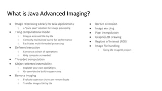
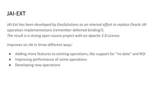
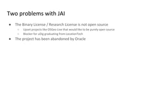
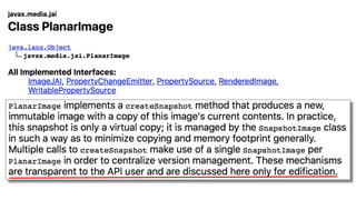
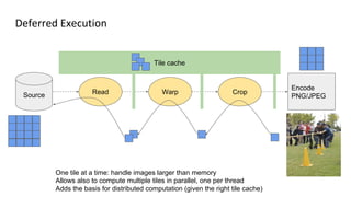
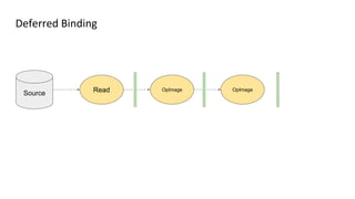
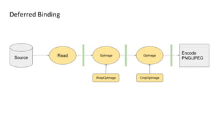
The document discusses Java Advanced Imaging (JAI) and its use in geospatial applications, highlighting JAI's features such as image processing, tiling, and deferred execution. It introduces jai-ext, an open-source alternative that enhances JAI by adding functionalities and improving performance, as well as other tools like Jiffle and Geotools. The discussion also touches on licensing issues, the limitations of current solutions, and the ongoing evolution of image processing technologies within the Java ecosystem.


![谷歌留痕技术教程[ 𝙩𝙤𝙥 𝟮𝟯𝟯. 𝙘 𝙤𝙢 ]](https://cdn.slidesharecdn.com/ss_thumbnails/top233-260130173900-2eb784f9-thumbnail.jpg?width=640&height=640&fit=bounds)


