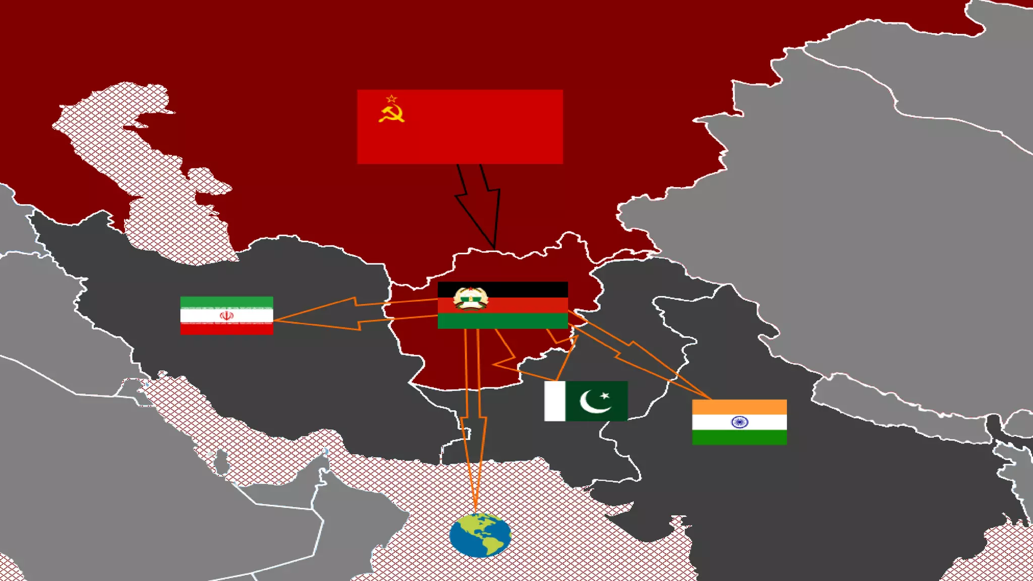
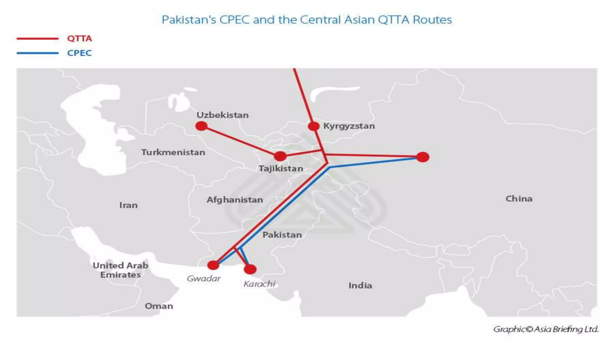
Geo-Political Status
of
Pakistan
Presented by:
Fahad Farooq
Osama Waheed
Hamza Iltaf
Huzaifa Ejaz Minhas
CONTENTS:
 Geo-Politics
 Geo-political value of Asia
 Geo-political Realities of South Asia
 Geo-political Value of Pakistan in South Asia
 Pakistan as a FRONT-LINE STATE
 Containment of china Via Pakistan
 Borders of Pakistan
 Natural Resources in Pakistan
 Conclusion
Geo-Political Significance
of
Pakistan
GEO-POLITICS:
• Analysis of the geographic influences on power relationships in international
relations.
• The word geopolitics was originally coined by the Swedish political scientist Rudolf
Kjellén.
• In contemporary discourse, geopolitics has been widely employed as a loose
synonym for international politics.
• At the level of international relations, geopolitics is a method of studying foreign
policy.
• Geopolitics focuses on political power linked to geographic space.
GEO-POLITICAL VALUE OF ASIA:
• Covers an area of 17,256,000 square miles. 1/3 of Earth’s land mass.
• World’s Largest continent with the population of 4.561 Billion.
• It is consist of 48 Countries.
• Asia is home to the world’s earliest civilizations.
• It is surrounded by 38 countries on the coast.
• sea-lanes in the Indian Ocean regulate roughly 80 to 90 percent of total world
trade.
• The social and political geography of the continent continues to inform and
influence the rest of the world.
GEO-POLITICAL REALITIES OF SOUTH ASIA:
• Region's history is shaped by its terrain. Foreign policy and national interests are
also impacted.
• South Asia is considered as the "Fulcrum" of Asia because of its location.
• The countries of Central Asia, China, the Gulf States, and Southeast Asia all meet
in South Asia.
• Inter-regional conflicts based on ideological differences, conflicting national
objectives.
• territorial disagreements, and political rivalry characterize the politics of this region.
GEO-POLITICAL VALUE OF PAKISTAN IN SOUTH
ASIA:
• Pakistan is a bridge connecting South Asia, South West Asia, and Central Asia.
• Iran and CARS have abundant energy resources, whereas India and China are energy
deficient.
• Through Afghanistan, Pakistan provides a direct land access to Iran and the CARs.
• Pakistan also offers a more cost-effective path to India for the IPI line project.
• During the Cold War, the Soviets conquered Afghanistan in order to gain access to
warm water via Pakistan's strategic location.
PAKISTAN AS A FRONT-LINE STATE:
• In her surrogate war against the Soviet Union, the United States exploited
Pakistan as a front-line state.
• Pakistan had payed high price in the war of terror (GWOT) because of its border
with Afghanistan.
• Pakistan is once again being used as a front-line state in the global war on terror.
• Now USA wants to use Pakistan to restrict china’s Economic Activities.
• USA is also interested for bases in Pakistan to keep an eye on whole region after
the exit from Afghanistan in Aug, 2021.
CONTAINMENT OF CHINA VIA PAKISTAN:
• The United States' objectives in the region are to restrict China's emerging influence.
• USA wants to stop Iran's nuclear ambitions, fight terrorism through Afghanistan, and
expand India as a balance to China.
• The United States is aiming to gain economic dominance in the Rest of Asia, which are
rich in petroleum resources.
• USA is not happy with CPEC Project in Pakistan.
• United States is achieving its security goals of maintaining its standing as the sole
superpower by restricting China's rise.
IMPORTANCE OF PAKISTAN FOR CENTRAL ASIAN
STATES
• With the disintegration of the Soviet Union, five important landlocked countries called Central
Asian Republics (CARs), emerged in Asia.
• They need Pakistan to conduct its transit trade towards South Asia and beyond.
• Pakistan and the Central Asian Republics are linked by several trade agreements.
• The $8 billion Turkmenistan, Afghanistan, Pakistan, and India (TAPI) gas pipeline project.
• CASA 1000 is another project under construction that would fill the energy sector gap
between the two regions.
• will provide a gateway to Indian Ocean waters to China and the Central Asian states.
BORDERS OF PAKISTAN:
• Pakistan is bordered by India to the east, Afghanistan to the northwest and Iran to
the west while China borders the country in the northeast.
• The nation is geopolitically situated within some of the most controversial regional
boundaries.
• share disputes and have many-a-times escalated military tensions between the
nations.
• Dispute of Kashmir with India and the Durand Line with Afghanistan.
• Its western borders include the Khyber Pass and Bolan Pass.
AFGHANISTAN–PAKISTAN BORDER:
• The border with Afghanistan which is known as the Durand Line, 2,670 km.
• Runs from the Hindu Kush and the Pamir Mountains.
• Southwestern Chaman border – one of the two main crossings between the two
neighbors.
• Pakistan and landlocked Afghanistan share 18 crossing points.
• most frequently used are northwestern Torkham and Chaman. Torkham border
was reopened on Sep,14, 2020.
• According to Pakistan Customs authorities, the border will remain open 24 hours
for trade activities.
CHINA–PAKISTAN BORDER:
• The eastern tip of the Wakhan Corridor starts the Sino-Pak border between the
People's Republic of China and Pakistan.
• The border length between both countries is 559 Km.
• It carries on south-eastward and ends near the Karakoram Pass.
• This line was determined from 1961 to 1965 in a series of agreements between
China and Pakistan.
• It is understood that if the dispute over Kashmir is resolved, the border would need
to be discussed again.
INDIA–PAKISTAN BORDER:
• The India–Pakistan border continues irregularly southward for about 1,280
kilometers, following the Radcliffe line.
• The international border-line has been a matter of pivotal dispute between
Pakistan and India ever since 1947.
• The Pakistan-India ceasefire line runs from the Karakoram Pass to northwest of
Lahore.
• This line, about 770 kilometers long, was arranged with United Nations.
• the Shimla Agreement was signed on 2 July 1972 between Indira Gandhi and
Zulfikar Ali Bhutto.
• Since then, it has been generally known as the Line of Control or the (LoC).
INDIA–PAKISTAN BORDER CONT…..
• The southern borders are far less contentious than those in northern Pakistan
(Kashmir).
• Wagha border connects Pakistan’s Lahore with India’s Amritsar.
• Independent and free Pakistan contested the southern boundary of Sindh, and a
succession of border incidents resulted.
• They were less dangerous and less widespread, however, than the conflict that
erupted in Kashmir in the Indo-Pakistani War of August 1965.
• Final stretch of Pakistan's border with India is about 80 kilometers long, running
east and southeast of Sindh to an inlet of the Arabian Sea.
IRAN–PAKISTAN BORDER:
• The boundary with Iran, 959 km (595.9 mi).
• first delimited by a British commission in the same year as the Durand Line was
demarcated.
• Separating Iran from what was then British India's Baluchistan province.
• Modern Iran has a province named Sistan va Baluchistan that borders Pakistan
and has Balochis in an ethnic majority.
• In 1957 Pakistan signed a frontier agreement with Iran in Rawalpindi according to
which the border was officially declared.
• Two countries haven't had this border as a subject of serious dispute at all.
NATURAL RESOURCES IN PAKISTAN:
Water Resources:
• Hydrological power is a renewable resource which benefits Pakistan a lot.
• After the Indus Water Treaty in 1960 World Bank decided that River Sutlej, Ravi
and Beas water will be used by India.
• River Indus, Jhelum and Chenab water will be used by Pakistan.
• Pakistan was told to build two dams, one tarbela and second Mangla, 5 barrages,
8 link canals, and 1 gated siphon.
• Pakistan largest river is known as the Indus River which flows from Tibet/China
and enters Pakistan through Gilgit Baltistan.
Fuel Resources:
• Pakistan has extensive energy resources in fairly sizable amount.
• Natural gas reserves, petroleum oil reserves, coal fields and large hydropower
potential.
Agriculture:
• About 26% of Pakistan's total land area is under cultivation and is watered by one
of the largest irrigation systems in the world.
• cotton, wheat, rice, sugarcane, maize, sorghum, millets, pulses, oil
seeds, barley, fruits and vegetables.
Fishery:
• Fishery and fishing industry plays an important role in the national economy of
Pakistan.
• With a coastline of about 1046 km, Pakistan has enough fishery resources that
remain to be fully developed.
Forestry:
• About only 4.1% of land in Pakistan is covered with forests.
• The forests of Pakistan are a main source of food, lumber, paper, fuel
wood, latex, medicine.
• as well as used for purposes of wildlife conservation and Eco tourism.
Mining:
• Salt Range in the Potwar Plateau has large deposits of rock salt.
• Pakistan has extensive mineral resources.
• reserves of gypsum, limestone, chromite, iron ore, rock salt, silver, gold.
• precious stones, gems, marbles, tiles, copper, sulfur, fire clay and silica sand.
Climate:
• All four seasons exist in Pakistan.
• Some Area are pleasant, some are hot and some are humid.
CONCLUSION:
• Pakistan's geostrategic, ideological, and political concerns are numerous, diverse,
nuanced, and compelling.
• encouraging self-reliance and austerity, which may be the foundation of our
national strategy in the future.
• Besides geopolitical and historical facts, maps, charts and data proving and
confirming this oneness were used.
• As has been often said, the unity is under risk from outsiders because of its
geographical location.
GEO-political Significance of Pakistan.pptx

GEO-political Significance of Pakistan.pptx

  • 1.
    Geo-Political Status of Pakistan Presented by: FahadFarooq Osama Waheed Hamza Iltaf Huzaifa Ejaz Minhas
  • 2.
    CONTENTS:  Geo-Politics  Geo-politicalvalue of Asia  Geo-political Realities of South Asia  Geo-political Value of Pakistan in South Asia  Pakistan as a FRONT-LINE STATE  Containment of china Via Pakistan  Borders of Pakistan  Natural Resources in Pakistan  Conclusion
  • 3.
  • 5.
    GEO-POLITICS: • Analysis ofthe geographic influences on power relationships in international relations. • The word geopolitics was originally coined by the Swedish political scientist Rudolf Kjellén. • In contemporary discourse, geopolitics has been widely employed as a loose synonym for international politics. • At the level of international relations, geopolitics is a method of studying foreign policy. • Geopolitics focuses on political power linked to geographic space.
  • 7.
    GEO-POLITICAL VALUE OFASIA: • Covers an area of 17,256,000 square miles. 1/3 of Earth’s land mass. • World’s Largest continent with the population of 4.561 Billion. • It is consist of 48 Countries. • Asia is home to the world’s earliest civilizations. • It is surrounded by 38 countries on the coast. • sea-lanes in the Indian Ocean regulate roughly 80 to 90 percent of total world trade. • The social and political geography of the continent continues to inform and influence the rest of the world.
  • 9.
    GEO-POLITICAL REALITIES OFSOUTH ASIA: • Region's history is shaped by its terrain. Foreign policy and national interests are also impacted. • South Asia is considered as the "Fulcrum" of Asia because of its location. • The countries of Central Asia, China, the Gulf States, and Southeast Asia all meet in South Asia. • Inter-regional conflicts based on ideological differences, conflicting national objectives. • territorial disagreements, and political rivalry characterize the politics of this region.
  • 11.
    GEO-POLITICAL VALUE OFPAKISTAN IN SOUTH ASIA: • Pakistan is a bridge connecting South Asia, South West Asia, and Central Asia. • Iran and CARS have abundant energy resources, whereas India and China are energy deficient. • Through Afghanistan, Pakistan provides a direct land access to Iran and the CARs. • Pakistan also offers a more cost-effective path to India for the IPI line project. • During the Cold War, the Soviets conquered Afghanistan in order to gain access to warm water via Pakistan's strategic location.
  • 13.
    PAKISTAN AS AFRONT-LINE STATE: • In her surrogate war against the Soviet Union, the United States exploited Pakistan as a front-line state. • Pakistan had payed high price in the war of terror (GWOT) because of its border with Afghanistan. • Pakistan is once again being used as a front-line state in the global war on terror. • Now USA wants to use Pakistan to restrict china’s Economic Activities. • USA is also interested for bases in Pakistan to keep an eye on whole region after the exit from Afghanistan in Aug, 2021.
  • 15.
    CONTAINMENT OF CHINAVIA PAKISTAN: • The United States' objectives in the region are to restrict China's emerging influence. • USA wants to stop Iran's nuclear ambitions, fight terrorism through Afghanistan, and expand India as a balance to China. • The United States is aiming to gain economic dominance in the Rest of Asia, which are rich in petroleum resources. • USA is not happy with CPEC Project in Pakistan. • United States is achieving its security goals of maintaining its standing as the sole superpower by restricting China's rise.
  • 17.
    IMPORTANCE OF PAKISTANFOR CENTRAL ASIAN STATES • With the disintegration of the Soviet Union, five important landlocked countries called Central Asian Republics (CARs), emerged in Asia. • They need Pakistan to conduct its transit trade towards South Asia and beyond. • Pakistan and the Central Asian Republics are linked by several trade agreements. • The $8 billion Turkmenistan, Afghanistan, Pakistan, and India (TAPI) gas pipeline project. • CASA 1000 is another project under construction that would fill the energy sector gap between the two regions. • will provide a gateway to Indian Ocean waters to China and the Central Asian states.
  • 20.
    BORDERS OF PAKISTAN: •Pakistan is bordered by India to the east, Afghanistan to the northwest and Iran to the west while China borders the country in the northeast. • The nation is geopolitically situated within some of the most controversial regional boundaries. • share disputes and have many-a-times escalated military tensions between the nations. • Dispute of Kashmir with India and the Durand Line with Afghanistan. • Its western borders include the Khyber Pass and Bolan Pass.
  • 22.
    AFGHANISTAN–PAKISTAN BORDER: • Theborder with Afghanistan which is known as the Durand Line, 2,670 km. • Runs from the Hindu Kush and the Pamir Mountains. • Southwestern Chaman border – one of the two main crossings between the two neighbors. • Pakistan and landlocked Afghanistan share 18 crossing points. • most frequently used are northwestern Torkham and Chaman. Torkham border was reopened on Sep,14, 2020. • According to Pakistan Customs authorities, the border will remain open 24 hours for trade activities.
  • 24.
    CHINA–PAKISTAN BORDER: • Theeastern tip of the Wakhan Corridor starts the Sino-Pak border between the People's Republic of China and Pakistan. • The border length between both countries is 559 Km. • It carries on south-eastward and ends near the Karakoram Pass. • This line was determined from 1961 to 1965 in a series of agreements between China and Pakistan. • It is understood that if the dispute over Kashmir is resolved, the border would need to be discussed again.
  • 26.
    INDIA–PAKISTAN BORDER: • TheIndia–Pakistan border continues irregularly southward for about 1,280 kilometers, following the Radcliffe line. • The international border-line has been a matter of pivotal dispute between Pakistan and India ever since 1947. • The Pakistan-India ceasefire line runs from the Karakoram Pass to northwest of Lahore. • This line, about 770 kilometers long, was arranged with United Nations. • the Shimla Agreement was signed on 2 July 1972 between Indira Gandhi and Zulfikar Ali Bhutto. • Since then, it has been generally known as the Line of Control or the (LoC).
  • 28.
    INDIA–PAKISTAN BORDER CONT….. •The southern borders are far less contentious than those in northern Pakistan (Kashmir). • Wagha border connects Pakistan’s Lahore with India’s Amritsar. • Independent and free Pakistan contested the southern boundary of Sindh, and a succession of border incidents resulted. • They were less dangerous and less widespread, however, than the conflict that erupted in Kashmir in the Indo-Pakistani War of August 1965. • Final stretch of Pakistan's border with India is about 80 kilometers long, running east and southeast of Sindh to an inlet of the Arabian Sea.
  • 30.
    IRAN–PAKISTAN BORDER: • Theboundary with Iran, 959 km (595.9 mi). • first delimited by a British commission in the same year as the Durand Line was demarcated. • Separating Iran from what was then British India's Baluchistan province. • Modern Iran has a province named Sistan va Baluchistan that borders Pakistan and has Balochis in an ethnic majority. • In 1957 Pakistan signed a frontier agreement with Iran in Rawalpindi according to which the border was officially declared. • Two countries haven't had this border as a subject of serious dispute at all.
  • 32.
    NATURAL RESOURCES INPAKISTAN: Water Resources: • Hydrological power is a renewable resource which benefits Pakistan a lot. • After the Indus Water Treaty in 1960 World Bank decided that River Sutlej, Ravi and Beas water will be used by India. • River Indus, Jhelum and Chenab water will be used by Pakistan. • Pakistan was told to build two dams, one tarbela and second Mangla, 5 barrages, 8 link canals, and 1 gated siphon. • Pakistan largest river is known as the Indus River which flows from Tibet/China and enters Pakistan through Gilgit Baltistan.
  • 34.
    Fuel Resources: • Pakistanhas extensive energy resources in fairly sizable amount. • Natural gas reserves, petroleum oil reserves, coal fields and large hydropower potential. Agriculture: • About 26% of Pakistan's total land area is under cultivation and is watered by one of the largest irrigation systems in the world. • cotton, wheat, rice, sugarcane, maize, sorghum, millets, pulses, oil seeds, barley, fruits and vegetables.
  • 36.
    Fishery: • Fishery andfishing industry plays an important role in the national economy of Pakistan. • With a coastline of about 1046 km, Pakistan has enough fishery resources that remain to be fully developed. Forestry: • About only 4.1% of land in Pakistan is covered with forests. • The forests of Pakistan are a main source of food, lumber, paper, fuel wood, latex, medicine. • as well as used for purposes of wildlife conservation and Eco tourism.
  • 38.
    Mining: • Salt Rangein the Potwar Plateau has large deposits of rock salt. • Pakistan has extensive mineral resources. • reserves of gypsum, limestone, chromite, iron ore, rock salt, silver, gold. • precious stones, gems, marbles, tiles, copper, sulfur, fire clay and silica sand. Climate: • All four seasons exist in Pakistan. • Some Area are pleasant, some are hot and some are humid.
  • 40.
    CONCLUSION: • Pakistan's geostrategic,ideological, and political concerns are numerous, diverse, nuanced, and compelling. • encouraging self-reliance and austerity, which may be the foundation of our national strategy in the future. • Besides geopolitical and historical facts, maps, charts and data proving and confirming this oneness were used. • As has been often said, the unity is under risk from outsiders because of its geographical location.