The document provides information on weather and climate in the UK. It discusses five main reasons for fluctuating temperatures: depressions that form in the Atlantic and bring rain; latitude affecting sunlight; prevailing southwest winds; proximity to seas; and pressure systems from the west. It also covers anticyclones that form high pressure and cause dry weather. The document notes the UK climate is becoming more extreme with more floods and higher temperatures, and discusses reducing impacts through preparation, planning, and warning systems.
CAMBRIDGE AS GEOGRAPHY REVISION: ATMOSPHERE AND WEATHER - 2.2 THE GLOBAL ENER...George Dumitrache
A comprehensive presentation of subchapter 2.2 The Global Energy Budget, from the second chapter of Physical Geography, AS Cambridge, Atmosphere and Weather.
CAMBRIDGE AS GEOGRAPHY REVISION: ATMOSPHERE AND WEATHER - 2.1 LOCAL ENERGY BU...George Dumitrache
A comprehensive presentation of subchapter 2.1 Local Energy Budgets, from the second chapter of Physical Geography, AS Cambridge, Atmosphere and Weather.
CAMBRIDGE AS GEOGRAPHY REVISION: ATMOSPHERE AND WEATHER - 2.3 WEATHER PROCESS...George Dumitrache
A comprehensive presentation of subchapter 2.3 Weather Processes and Phenomena, from the second chapter of Physical Geography, AS Cambridge, Atmosphere and Weather.
CAMBRIDGE GEOGRAPHY AS ULTRA REVISION TEST 2 ATMOSPHERE AND WEATHERGeorge Dumitrache
Cambridge Geography AS Ultra Revision Test 2, with questions and answers for chapter 2 Atmosphere and Weather. This is a test with 30 questions, 2 minutes each.
This presentation encompasses what cyclones (tropical and midlatitude) are and how they form even where they occur. Even though almost all types of cyclones are highlighted in the slide the main focus is on Tropical and Mid-latitude cyclones. This is very helpful when one is searching for specifically the two types of cyclones.
GEOGRAPHY IGCSE: WEATHER MEASUREMENTS. It contains: difference between weather and climate, measuring the weather, what do we measure, temperature, precipitation, wind direction, Beaufort scale, cloud cover, air pressure, glossary.
AS Level Physical Geography - Rocks and WeatheringArm Punyathorn
The earth's surface is an ever-changing entity. With the forces of weather and climate and tectonic variability, the rocks and minerals that make up the earth are always changing in size, shape and forms - a fascinating, ancient, never-ending process.
GEOGRAPHY IGCSE: TROPICAL STORMS. It contains: hurricanes, how hurricanes form, preparation and prediction, effects of tropical storms, case study hurricane Katrina 2005, impacts, responses, glossary.
CAMBRIDGE GEOGRAPHY A2 REVISION - PRODUCTION, LOCATION AND CHANGE: 11.1 AGRICULTURAL SYSTEMS AND FOOD PRODUCTION. It contains: ley terms and definitions, topic summary, additional work and suggested websites.
CAMBRIDGE AS GEOGRAPHY REVISION: HYDROLOGY AND FLUVIAL GEOMORPHOLOGY - 1.2 RA...George Dumitrache
A presentation of the second subchapter (Rainfall Discharge Relationships) from the first chapter (Fluvial Geomorphology) of Revision for Geography AS Cambridge exams.
Geography notes Hydrology, Atmosphere, Weathering, Population and Migration
Casestudies aren't included - sorry. Hope these are helpful. Good luck everyone with your exams.
This activity helps you to revise the types of rainfall. Drag the labels to appropriate points on the slide then custom animate to help you explain the processes of relief, convectional and frontal rainfall.
Global Warming and Climate Change Group-7.pptxSN Showrov
This is was a simple presentation task assigned in a B.Sc. civil engineering course of AUST.
Different information and necessary pictures from different sites were included and combined presentation slide was formed on topic of "Global Warming and Its reasons:Man made or otherwise".
This slide is only for study purpose and a sample one on how to make a similar slide regarding global warming highlighting other reasons.
a change in global or regional climate patterns, in particular a change apparent from the mid to late 20th century onwards and attributed largely to the increased levels of atmospheric carbon dioxide produced by the use of fossil fuels.
The causes and effects of climate changeColin Mattis
The document gives an introduction to climate change. it gives a definition for weather, climate and climate change. it gives the causes and effects of climate change and strategies that can be implemented to mitigate climate change.
Few global trends have been as controversial as climate change and the Earth’s warming. The Earth has gone through many shifts in cooling and warming driven by natural factors like the sun’s energy or variations in its orbit, but the trend scientists have seen over the past 50 years is unmistakable.
(May 29th, 2024) Advancements in Intravital Microscopy- Insights for Preclini...Scintica Instrumentation
Intravital microscopy (IVM) is a powerful tool utilized to study cellular behavior over time and space in vivo. Much of our understanding of cell biology has been accomplished using various in vitro and ex vivo methods; however, these studies do not necessarily reflect the natural dynamics of biological processes. Unlike traditional cell culture or fixed tissue imaging, IVM allows for the ultra-fast high-resolution imaging of cellular processes over time and space and were studied in its natural environment. Real-time visualization of biological processes in the context of an intact organism helps maintain physiological relevance and provide insights into the progression of disease, response to treatments or developmental processes.
In this webinar we give an overview of advanced applications of the IVM system in preclinical research. IVIM technology is a provider of all-in-one intravital microscopy systems and solutions optimized for in vivo imaging of live animal models at sub-micron resolution. The system’s unique features and user-friendly software enables researchers to probe fast dynamic biological processes such as immune cell tracking, cell-cell interaction as well as vascularization and tumor metastasis with exceptional detail. This webinar will also give an overview of IVM being utilized in drug development, offering a view into the intricate interaction between drugs/nanoparticles and tissues in vivo and allows for the evaluation of therapeutic intervention in a variety of tissues and organs. This interdisciplinary collaboration continues to drive the advancements of novel therapeutic strategies.
A brief information about the SCOP protein database used in bioinformatics.
The Structural Classification of Proteins (SCOP) database is a comprehensive and authoritative resource for the structural and evolutionary relationships of proteins. It provides a detailed and curated classification of protein structures, grouping them into families, superfamilies, and folds based on their structural and sequence similarities.
Seminar of U.V. Spectroscopy by SAMIR PANDASAMIR PANDA
Spectroscopy is a branch of science dealing the study of interaction of electromagnetic radiation with matter.
Ultraviolet-visible spectroscopy refers to absorption spectroscopy or reflect spectroscopy in the UV-VIS spectral region.
Ultraviolet-visible spectroscopy is an analytical method that can measure the amount of light received by the analyte.
Professional air quality monitoring systems provide immediate, on-site data for analysis, compliance, and decision-making.
Monitor common gases, weather parameters, particulates.
Multi-source connectivity as the driver of solar wind variability in the heli...Sérgio Sacani
The ambient solar wind that flls the heliosphere originates from multiple
sources in the solar corona and is highly structured. It is often described
as high-speed, relatively homogeneous, plasma streams from coronal
holes and slow-speed, highly variable, streams whose source regions are
under debate. A key goal of ESA/NASA’s Solar Orbiter mission is to identify
solar wind sources and understand what drives the complexity seen in the
heliosphere. By combining magnetic feld modelling and spectroscopic
techniques with high-resolution observations and measurements, we show
that the solar wind variability detected in situ by Solar Orbiter in March
2022 is driven by spatio-temporal changes in the magnetic connectivity to
multiple sources in the solar atmosphere. The magnetic feld footpoints
connected to the spacecraft moved from the boundaries of a coronal hole
to one active region (12961) and then across to another region (12957). This
is refected in the in situ measurements, which show the transition from fast
to highly Alfvénic then to slow solar wind that is disrupted by the arrival of
a coronal mass ejection. Our results describe solar wind variability at 0.5 au
but are applicable to near-Earth observatories.
Multi-source connectivity as the driver of solar wind variability in the heli...
Geography revision weather and climate
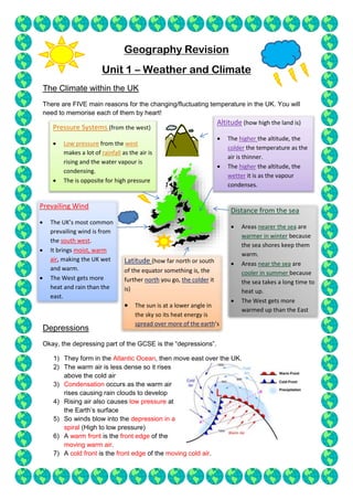
1. Geography Revision
Unit 1 – Weather and Climate
The Climate within the UK
There are FIVE main reasons for the changing/fluctuating temperature in the UK. You will
need to memorise each of them by heart!
Depressions
Okay, the depressing part of the GCSE is the “depressions”.
1) They form in the Atlantic Ocean, then move east over the UK.
2) The warm air is less dense so it rises
above the cold air
3) Condensation occurs as the warm air
rises causing rain clouds to develop
4) Rising air also causes low pressure at
the Earth’s surface
5) So winds blow into the depression in a
spiral (High to low pressure)
6) A warm front is the front edge of the
moving warm air.
7) A cold front is the front edge of the moving cold air.
Latitude (how far north or south
of the equator something is, the
further north you go, the colder it
is)
The sun is at a lower angle in
the sky so its heat energy is
spread over more of the earth’s
surface.
Prevailing Wind
The UK’s most common
prevailing wind is from
the south west.
It brings moist, warm
air, making the UK wet
and warm.
The West gets more
heat and rain than the
east.
Distance from the sea
Areas nearer the sea are
warmer in winter because
the sea shores keep them
warm.
Areas near the sea are
cooler in summer because
the sea takes a long time to
heat up.
The West gets more
warmed up than the East
due to the North Atlantic
Pressure Systems (from the west)
Low pressure from the west
makes a lot of rainfall as the air is
rising and the water vapour is
condensing.
The is opposite for high pressure
Altitude (how high the land is)
The higher the altitude, the
colder the temperature as the
air is thinner.
The higher the altitude, the
wetter it is as the vapour
condenses.
2. People’s homes and lives
Floods damaged homes and prized
possessions
Businesses were flooded
Contaminated water supplies
In drought, a lack of water supplies. E.g.
the “hose pipe ban”
Health
Flood can cause deaths by drowning
Heat waves can cause death by heat
exhaustion
Milder winters may reduce cold-related
deaths
Transport
Floods can block roads and railways,
disrupting transport systems
High temperatures can cause railway lines
to buckle so trains can’t run properly
People will become anti-social and
isolated due to a lack of transport
Agriculture
Droughts will cause crop failures
Increased rainfall could be good and
increase production
A warmer climate means farmers can
grow a wider variety of crops
Anticyclones
These are almost the opposite of a depression. They cause clear skies and dry weather.
1) These also form in the Atlantic Ocean and move east over the UK.
2) These create high pressure as the warm air is
falling
3) This warm air can hold more water so there is NO
RAIN.
4) Creates clear skies in summer, however, it’s very
different in winter
5) In winter, anticyclones give long periods of cold,
foggy weather. Heat is lost from the earth’s surface at
night because there are no clouds to reflect it back. The
temperature drops and condensation occurs near the
surface.
Extreme UK weather
The weather in the UK is getting more extreme. In other words, there is more rain; more
floods and temperatures are increasing. The impacts of this changing climate are as follows:
Reducing Negative Impacts
1) Preparing – flood defences and better education of the issue
2) Planning – emergency services should know all the procedures
3) Warning – warning systems give people time to prepare for extreme weather
3. Threat of Global Climate Change
Climate change is any change in the weather of an area over a long period. Global warming
is the increase in global temperature over the last century.
1) Global temperature has been measured using thermometers for the last 150 years.
During the last 100 years, average global temperature has risen by about 0.9*c.
2) Scientists have also reconstructed the climate over the last 1000 years using things
like historical records, tree rings and cores taken from ice sheets.
3) This shows that global temperature is rising sharply now compared to how it was in
the past
4) There’s some other evidence too:
Ice sheets are melting
Sea level is rising
Causes
1) An increase in human activities like burning fossil fuels and deforestation has caused
an increase in the concentration of carbon dioxide and methane
2) These are greenhouse gases – they trap heat reflected off the Earth’s surface
3) Greenhouse gages keep the Earth warm because they trap heat. Increasing the
concentration of greenhouse gasses in the atmosphere means the Earth heats up
too much – causing global warming.
Impacts
Economic Impacts – Climate change will affect farming in different ways round the world. In
higher latitudes, warmer weather will mean some farmers can make more money – some
crop yields will be increase, and they’ll be able to grow new types of crops to sell.
Social Impacts – People won’t be able to grow as much food in lower latitudes. This could
lead to malnutrition, ill health and death from starvation.
Environmental Impacts – Global warming is causing sea level to rise, so some habitats will
be lost as low-lying coastal environments are submerged. Rising temperature and
decreased rainfall will mean some environments will turn into deserts.
Political Impacts – Water will become scarcer in some places. Competition over water could
lead to war between countries. Climate change may cause people to move, therefore
increased immigration.
Reponses
International – Kyoto Protocol, their aim is to reduce global greenhouse gas emissions by
5% below 1990 levels by 2012. Each country is set a target and there are meetings to make
sure countries are keeping to their target. America is not included in this.
National - Transport strategies can be improved upon, making sure less people use the car.
Taxation on high polluting vehicles and factories could also reduce emissions.
Local – Conserving energy, recycling and congestion charging will all reduce emissions.
4. Tropical Storms
Tropical storms create quite a lot of havoc. This is where the hurricanes come in. Most
people will be doing hurricane Katrina as an MEDC and Burma as an LEDC. Tropical storms
are called a variety of things such as hurricanes or typhoons, but they are all basically the
same thing.
This is how they are formed:
1) Only formed when sea water is 27*c or higher.
2) Happen in late summer or autumn
3) Warm moist air rises and condenses
4) They move west because of the easterly winds near the equator
5) They lose strength when they move over land because the energy supply from the
water is cut off
6) Most tropical storms happen between 5* and 30* degrees north and south of the
equator, any further north and the water isn’t hot enough
7) The Earth’s rotation deflects the path of the winds which causes the storms to spin
Characteristics
Anti-clockwise spin and move north west.
They’re circular in shape and usually last between 7 and 14 days
The lose their strength when they move over land
They are extremely powerful due to their consistent
spirally of hot air
The Eye
Low pressure
High temperature
No clouds
No rain
The Eye wall
Low temperature
Spiralling rising air
Strong winds
Torrential rain
The Edge
Low pressure
High temperature
No clouds
No rain