Puget Sound is feeling the heat! Starting in October, temperatures are the highest on our record since 1989. Salinity and oxygen are much lower. Recent rains have rivers flowing high. Aerial views show dramatic sediment loads from rivers mixing into otherwise blue water. But don’t be fooled – by summer, snow-fed rivers are expected to run significantly below normal, with implications for Puget Sound water quality. For details, explore the special Drought Effects segment. Spring blooms are visible only in some confined bays. Jellyfish are going strong in finger inlets of South Sound. Glimpse Puget Sound’s glacial history.
Unusually warm water temperatures continue in central and south Puget Sound. River flows remain lower than normal, especially the Fraser and Skagit rivers. Thus, with estuarine circulation much weaker, Puget Sound waters stay put. Mats of organic debris persist in Central Sound near Port Madison. Red-brown and brown blooms are now very strong in southern inlets and jellyfish patches are exceptionally numerous and large. Explore media coverage of unusual Puget Sound conditions including jellyfish.
Air temperatures are warm and Puget Sound continues to show record high water temperatures. Some rain has returned to our region, yet river flows remain unusually low. Puget Sound is saltier than normal allowing oxygen-rich surface waters to more easily mix to greater depths. Lower oxygen was measured only in the Coastal Bays, Hood Canal, and South Sound. Large jellyfish aggregations continue in South Sound, the Kitsap Peninsula, and East Sound (Orcas Island). Sediment plumes in Bellingham Bay form unique patterns. Warm waters and sunny conditions fostered green tides, raising a stink along some local beaches.
Puget Sound is starting to normalize in response to fall conditions with cooler air temperatures, rain, and recovering river flows. We are seeing fewer algal blooms, jellyfish, and macro-algae as salinities become more normal. Yet warm waters persist and El Nino and the Blob are likely to affect Puget Sound throughout the winter. The Nisqually River fared better through the drought than other rivers and best management practices have been improving its water quality. EOPS and ferry monitoring gain recognition with a national award for innovation!
Warm waters from “The Blob” in Puget Sound combine with drought conditions as warm air has left little snow to feed the rivers. Water temperatures throughout Puget Sound are the highest in 25 years and oxygen is exhibiting record lows. High suspended sediment in the north is still coming in from the Fraser River. Otherwise, the surface waters appear very clear due to recent low river flows and weak blooming activity. A red bloom is present in Sinclair Inlet and in some confined bays. Patches of jellyfish, however, are going strong in inlets of South Sound and Sinclair Inlet. What does this all mean for salmon? Get to know some intertidal critters!
EOPS_July_20_2016,
Through June, air temperatures and sunlight were higher than normal. Recent rain generally improved river flows. However, the Fraser river flow remains extremely low, reducing water exchange with the ocean. Water temperatures are still breaking records, yet dissolved oxygen levels are normal. Coastal bays are influenced by upwelling and exhibit lower oxygen and higher salinities. Puget Sound algae are thriving with blooms observed in many South Sound inlets. Macro-algae is seen piling up on beaches and drifting in Central Sound. Jellyfish smacks are numerous in Eld and Budd Inlets. Our fliers notice seals hanging out at the beach!
Ecology Publication No. 16-03-075
After a dry and sunny summer extending well into October, air temperatures are cooler than normal and precipitation has increased allowing rivers to regain strength. Despite a dry summer, Puget Sound is fresher this year than the past 17 years. As of September, warmer temperatures remained in South Sound. In October, surface water in the Straits however began to cool and the influence of rivers can be seen in our ferry data. Leaves drift on the water in South Sound and smaller blooms are confined to inlets as the productive season winds down. Meet our new intern and discover if Puget Sound really has sea spiders.
The ocean and air remain warm with sunshine and dry weather across the region. As a result, Puget Sound is a lot warmer going into the new year. Hood Canal is responding with temperatures warmer than previous measurements, breaking its low temperature stint. First signs of growing phytoplankton are coloring the water green. Patches of jellyfish are overwintering in finger inlets of South Sound. Tidal fronts and suspended sediment are visible amidst the stunning San Juan Islands scenery. A sediment-rich water mass is trapped in Rosario Strait. Check out the South Sound Estuarium and the many reasons we love Puget Sound!
EOPS_September_26_2016,
September is jellyfish season and they are everywhere in southern Puget Sound! Sunny, warm, and dry conditions promoted strong late-summer plankton blooms in colors of red, green, and brown, now widespread in many bays. In contrast, Central Sound looks clear with low algal activity. Southern Puget Sound has large floating mats of organic material and developed lower oxygen in August. Meet the Critter of the Month - The Sweet Potato Sea Cucumber.
Publication No. 16-03-077
EOPS_July_24_2017,
July had warm air temperatures, sunshine, and an abundant snowpack. Previous months had higher river flows (bringing freshwater) and weak upwelling (low delivery of saltier water) which resulted in very low salinities in Puget Sound, especially in the South Sound. Water temperatures are expected and warmer in Central Sound. Above normal sunshine has made Puget Sound biologically very active! Intense and unusual blooms color Hood Canal (coccolithophores) and south sound inlets. Large mats of organic material containing macro-algae drift at the surface. Many schools of fish are visible though jellyfish were absent.
Ecology Publication No. 17-03-071
EOPS_February_8_2016,
January air temperatures and precipitation were above normal as El Nino conditions prevail. This winter our snowpack is in much better shape, though we’ve lost some snow from the stint of warm weather. More rain and higher river flows have lowered salinities in Puget Sound and coastal bays. Nonetheless, water temperatures in Puget Sound remain at record-breaking highs. Jellyfish patches are numerous in finger inlets of South Sound and signs of phytoplankton blooms are visible in coastal bays. When conditions limit flying, Ecology’s research vessel gets the job done.
Publication No. 16-03-070
EOPS_May_2_2016,
Spring air temperatures are higher - it has been sunny and dry. The snowpack is quickly disappearing as temperatures are up to 7 °F warmer at higher elevations. Snowmelt-fed rivers are running very high. How does this affect water quality in Puget Sound? A strong spring phytoplankton bloom extends across Puget Sound and the Strait of Juan de Fuca. Water temperatures are still higher than normal and jellyfish are already numerous in southern inlets. The high biological activity is causing organic material to drift at the surface and wash onto beaches. Do you know how fast a Sand Star can move?
Ecology Publication No. 16-03-073
EOPS_August_24_2016,
In July, conditions were normalizing, yet river flows remained lower, continuing into August. July also saw lower oxygen appearing in southern Puget Sound. By August, jellyfish are occurring in high numbers in Eld and Budd Inlet. South Puget Sound has Noctiluca drifting at the surface in large orange lines in many places and red-brown blooms widespread in finger inlets, as well as in Sinclair Inlet. Central Sound surface-water temperatures are high, still in the 60s, and algae are abundant. See what we are measuring to understand ocean acidification in Puget Sound.
Publication No. 16-03-076
A stunning view of a second large Noctiluca bloom captures the attention of many living near Puget Sound. Favorable conditions support several regional phytoplankton blooms. Red-brown blooms in Port Townsend, Discovery Bay and Bellingham Bay. Large algal mats or organic material particularly in Samish Bay. Jellyfish patches increasing in Budd, Totten and Eld Inlets.
EOPS_March_16_2016,
In response to warm and wet conditions, rivers have been running high. Salinity in Puget Sound is notably lower. Below a cooler surface, water temperatures remain high, especially in Hood Canal. We still see numerous jellyfish patches in Puget Sound inlets. Phytoplankton blooms are going strong in Hood Canal and Henderson Inlet, and picking up elsewhere. Many places showed long stretches of suspended sediments nearshore, a sign of potential shore erosion. Check out the critters inhabiting the sediments of Puget Sound.
Ecology Publication No. 16-03-071
Puget Sound conditions are normalizing after seven months of lower oxygen. Calm, dry, cool, and foggy mornings abruptly changed on October 28 to sun and strong northerly winds. Red-brown blooms and abundant jellyfish in south Puget Sound inlets appeared as we flew to the coast. Blooms were still visible near ocean beaches and inner bays. Grays Harbor had abundant surface debris with green algae in North Bay. We spotted red-brown blooms in rivers and sloughs in Willapa Bay, as well as schooling fish near sandbanks. Many patches of suspended sediment appeared in shallow water unrelated to tidal currents and remain unexplained.
EOPS_November_22_2016,
ENSO is in a cold phase (La Niña) and it is wetter and warmer than normal. Strong precipitation in October greatly improved Puget Sound streamflows. At the coast, we had strong downwelling. As a result, water temperatures, salinities, and oxygen in Puget Sound are returning to normal. While surface water in Puget Sound has cooled, it is still warmer than in the Straits. Surprisingly, masses of suspended sediment occurred east of Steamboat Island in Totten Inlet. We continue to see large jellyfish aggregations in finger Inlets of South Sound and slowly fading red-brown blooms.
Publication No. 16-03-078
Abundant sunshine gives rise to large algal mats in South Sound, Hood Canal, and Sinclair Inlet. Red-brown algal blooms dominate in Budd, Totten, and Eld Inlets and jellyfish begin to increase. Northerly winds push algal blooms from Whidbey and Central Basins past Seattle and a bloom in northern Hood Canal southward. Satellite thermal imagery shows patterns of near-surface mixing and injection of nutrients into the surface layer. Glacial-fed rivers deliver glacial flour into Commencement Bay, stratifying the water and supporting different colored phytoplankton blooms (green, brown, and red). Since the beginning of 2013, dissolved oxygen is dropping below expected values.
EOPS_June_5_2017,
Cooler and wetter conditions early in 2017 have set the stage for a favorable supply of freshwater. River flows are all above normal due to melting of the abundant snowpack from warmer May air temperatures. This is creating significantly fresher conditions in Puget Sound surface waters. Algae blooms are limited to some yellow-green blooms growing in bays near the Kitsap Peninsula and blooms near estuaries of the Skagit, Stillaguamish, and Puyallup Rivers. Red blooms are present in rivers feeding into Willapa Bay. Also see what is “blooming” in the sediments of Puget Sound.
Ecology Publication No. 17-03-070
EOPS_June_27_2016,
Record-breaking warmer and fresher water in Puget Sound. May-June conditions are more unusual than last year. Recent rain brought river flows close to normal but water exchange in Puget Sound remains weak due to low Fraser River flow. Phytoplankton blooms and organic material are visible in some areas of Central and South Sound but not in others. Noctiluca, while absent in Central Basin, was reported in unusual places. Jelly fish occur only in some south sound bays. Follow our BEACH program kick off, discover the Stinkworm, and find good underwater visibility for diving.
Ecology Publication No. 16-03-074
EOPS_December_14_2015,
As coastal and regional conditions gradually normalize in response to a fading Blob and increased rain, the big question remains. Will the snow in the mountains stay there or come down prematurely and lower salinity in Puget Sound like last winter? Cascade snowpack is currently below normal. The El Niño at the equator is still brewing! Major rivers transport large amounts of suspended sediments and soil into Puget Sound, also seen in our ferry sensor data. Our flight team gets in the pool for safety training.
Ecology Publication No. 15-03-079
A recent cold spell hits Puget Sound lowlands, interrupting this year’s warmer air temperatures. The warm ocean coincides with new maximum water temperatures observed throughout Puget Sound in October! Hood Canal’s higher dissolved oxygen and cold water anomalies are disappearing. November brings cold water from Whidbey Basin into Puget Sound with moderate levels of chlorophyll fluorescence. Abundant smacks of jellyfish in finger inlets of South Sound observed from our flight. Red-brown blooms remain strong in smaller bays of South Sound. Visible suspended sediments in the coastal estuaries from rain, wind, and waves. Playing in the water? Visit our BEACH program.
EOPS_December_30_2015,
The year 2015 in pictures: Jellyfish patches persisted through the entire year in response to the exceptionally warm water caused by the Blob. Sediment loads are high as snow melts fast in the winter of 2015. Unexpected phytoplankton species occur in some bays in spring. Noctiluca, jellyfish and macro-algae appear in high numbers when rivers drop to record-low flows in early summer. Low river flows slow the renewal of in Puget Sound throughout summer and fall and jellyfish patches reach record highs.
Ecology Publication No. 15-03-080
Warmer and sunnier days result in higher than normal river flows from the Skagit and Nisqually. Biological activity in the water column is high. Abundant organic surface debris in Hood Canal, Padilla Bay, and many Inlets. Red-brown blooms in South Sound, Discovery Bay, and regions of Bellingham Bay. Different blooms in Skagit Bay, Padilla Bay, and Sinclair Inlet. Jelly fish are numerous in all southernmost South Sound Bays. Hood Canal remains cold but Puget Sound-wide temperatures are now warmer and less salty. Data from the Victoria Clipper and our sampling in the Strait provides important information on water exchange with the ocean.
River flows are above normal and air temperatures are increasing slowly. The spring phytoplankton bloom is slow to develop with visible blooms limited to smaller bays such as Sequim and Bellingham Bays. Noctiluca observed in East Sound on Orcas Island, coinciding with high numbers of jellyfish. Debris lines are mostly confined to Hood Canal. Pockets of colder water observed in Central Sound and Hood Canal, likely from the colder, saltier conditions that developed during the winter in the northern regions. Oxygen is variable yet close to expected ranges. Sizable oil sheens were sighted in Gig Harbor and Carr Inlet.
Eyes Over Puget Sound (EOPS) is a news report, and is made available within two days of observation.
http://www.ecy.wa.gov/programs/eap/mar_wat/eops/
We inform on current surface conditions in Puget Sound and links several scales of observation together. The report contains condition summaries, personal flight observations, aerial photographs, en route ferry data, satellite images, and mooring data collected by the Marine Monitoring Unit at Ecology.
Ecology's Marine Monitoring Unit conducts several marine observations with a sampling frequency of minutes to 1 month. We use our routine commute flight between Kenmore Airbase and Olympia to document current marine water conditions by camera and supplement the information with satellite images and en route ferry data between Seattle WA and Victoria BC. This program is an example to optimize monitoring resources. You may subscribe or unsubscribe to the Eyes Over Puget Sound email listserv by going to this link:
http://listserv.wa.gov/cgi-bin/wa?A0=ECOLOGY-EYES-OVER-PUGET-SOUND
The pattern of colder and fresher Puget Sound water persists. Jellyfish aggregations continue to persist in Budd Inlet. Debris lines are numerous and long. There are multiple oil sheens in Seattle waterways. CDOM (colored dissolved organic matter) sensor and en route ferry thermosalinograph provide an important tracer for freshwater entering Puget Sound from Whidbey Basin.
The year 2014 in pictures: In 2014, Puget Sound and Hood Canal behaved distinctly different in temperature and dissolved oxygen. In Puget Sound, generally warmer conditions, abundant and diverse algal blooms, and large pools of organic material persisted along with lower oxygen, high jellyfish abundances, and a lot of suspended sediment. On the other hand, Hood Canal was colder, more oxygenated, and algae blooms were rare. People and planes: past and present.
Sunshine and warmth continue into September. Upwelling is higher, yet low Fraser River flow reduces the likelihood of low-oxygen water moving into Puget Sound. Dissolved oxygen remains relatively high in Hood Canal and is lower elsewhere. Satellites show relatively warm water in the Strait of Georgia and Whidbey Basin and an extensive offshore bloom. Water temperatures also remain high in South Sound were red-brown plankton blooms and large smacks of jellyfish adorn the water surface. Explore what frequent blooms in smaller bays can tell us.
Sunshine and warm temperatures return after last week’s intense rain. The Puyallup and Nisqually Rivers are flowing high. Red-brown blooms and numerous patches of jellyfish remain strong in South Sound, Sinclair and Dyes Inlets, and Bellingham Bay, with brown-green blooms in Whidbey Basin. Macro-algae surface debris is very high in South and Central Sound. Hood Canal remains cooler but Puget Sound-wide temperatures are now warmer and less salty. Sea surface temperatures are above 15 °C, conditions favorable for some pathogens, and harmful algae blooms. Read about super colonies of by-the-wind sailors washing up on our shores.
Eyes Over Puget Sound (EOPS) is a news report, and is made available within two days of observation.
http://www.ecy.wa.gov/programs/eap/mar_wat/eops/
We inform on current surface conditions in Puget Sound and links several scales of observation together. The report contains condition summaries, personal flight observations, aerial photographs, en route ferry data, satellite images, and mooring data collected by the Marine Monitoring Unit at Ecology.
Ecology's Marine Monitoring Unit conducts several marine observations with a sampling frequency of minutes to 1 month. We use our routine commute flight between Kenmore Airbase and Olympia to document current marine water conditions by camera and supplement the information with satellite images and en route ferry data between Seattle WA and Victoria BC. This program is an example to optimize monitoring resources. You may subscribe or unsubscribe to the Eyes Over Puget Sound email listserv by going to this link:
http://listserv.wa.gov/cgi-bin/wa?A0=ECOLOGY-EYES-OVER-PUGET-SOUND
At the end of summer, water temperatures are still high, and salinities and dissolved oxygen are low in Puget Sound. Both sea surface temperature and upwelling off the coast are elevated (PDO and Upwelling indices) and the the Fraser River flow is low. This combination makes it an interesting fall. Very dense and large patches of jellyfish appear in finger inlets of South Sound. Red-brown blooms also remain strong in South Sound.
Air temperatures are warm and Puget Sound continues to show record high water temperatures. Some rain has returned to our region, yet river flows remain unusually low. Puget Sound is saltier than normal allowing oxygen-rich surface waters to more easily mix to greater depths. Lower oxygen was measured only in the Coastal Bays, Hood Canal, and South Sound. Large jellyfish aggregations continue in South Sound, the Kitsap Peninsula, and East Sound (Orcas Island). Sediment plumes in Bellingham Bay form unique patterns. Warm waters and sunny conditions fostered green tides, raising a stink along some local beaches.
Dr. Christopher Krembs, with the marine monitoring unit of the Department of Ecology, presented on the warm water conditions in Puget Sound. He discussed the impacts on marine food webs and potential scenarios in 2015. He presented at the June 2015 NRC meeting.
El 12 de noviembre de 2015 dedicamos una jornada en la Fundación Ramón Areces a analizar la actual situación del Ártico. El Simposio Internacional se ocupó de las oportunidades y riesgos derivados del cambio climático. En este encuentro participaron expertos de Canadá, Estados Unidos, Finlandia, Noruega, Suecia, Alemania, Portugal y España.
EOPS_August_28_2017,
Warm air temperatures, abundant sunshine, and drier conditions persisted. River flows are lower in the north. Puget Sound waters are still fresher than in the past 17 years from the combination of abundant spring rain and weak upwelling bringing less salty water from the ocean. July upwelling was stronger, however. Warmer water temperatures are notable in parts of Central Sound, accompanied by large rafts of drifting macroalgae. Diverse blooms in colors of green, orange and red-brown are present in many inlets. Jellyfish abundance is lower this year. Find out how we assess if the benthos is changing.
Ecology Publication No. 17-03-072
After 2-years of conditions favorable for water quality, with colder temperatures and higher oxygen, Puget Sound water conditions are closer to expected again. This year phytoplankton blooms and seasonal oxygen maxima are notable, while extensive Noctiluca blooms showed up early following a period high freshwater inputs and milder weather conditions. The Fraser River sediment influence is very strong north of San Juan Islands and warm, fresh water is entering Central Puget Sound from Whidbey Basin. In the past few weeks river flows and air temperatures have been higher than normal and now are decreasing.
Unusually warm water temperatures continue in central and south Puget Sound while Willapa Bay returns to expected water temperatures as a result of stronger coastal upwelling. Extensive mats of organic debris develop in many places, particularly in Central Sound overlapping with a fading Noctiluca bloom. King County confirms Noctiluca and shares plankton species information. Red-brown and brown blooms are going strong in southern inlets and around the San Juan Islands. Our inspiring WCC Intern gets on boats, into the air, and to the lab.
Record warm water temperatures and low oxygen continue in Ecology’s Puget Sound marine monitoring station network. Record low stream flows result in visibly low river discharge into Puget Sound, in particular for the Puyallup River. Abundant sun and unusually warm water temperatures fuel phytoplankton blooms in many areas. Bright orange Noctiluca blooms are surfacing in the Commencement Bay area and around Port Madison. Finger inlets of South Sound support extensive patches of jellyfish.
Warm air and water temperatures and offshore winds have persisted since fall. Numerous and sizable jelly fish patches are still present in southern inlets of Puget Sound. Coastal waters were colored in shades of gray to brown by sediment and humic substances. Phytoplankton blooms were restricted to the surf zone. We were treated to artful views of meandering sloughs and gullies on exposed mud flats during low tide in Willapa Bay, interspersed with the geometry of shellfish management. Brown pelicans: a story of recovery.
After weeks of clouds and warmer air, blue skies and cold temperatures set in. Strong tidal fronts and sediment-rich brackish plumes leave Whidbey Basin and move into Admiralty Reach. A pod of Orcas follows the edge of the plume heading north! Red-brown blooms continue in Henderson, Eld, and northern Budd Inlets. Long organic debris lines are numerous in northern Budd Inlet, Hood Canal, and in Central Sound north of Edmonds (Triple Junction). Conditions in the water column in Puget Sound continue to normalize after seven months of lower oxygen. Water is very clear for this time of the year, particularly in the north.
Sun and high air temperatures warrant en route ozone measurements for model validations. A furry visitor takes a rest on the float plane. Spotlight on our pilot, Joe Leatherman. High river flows lead to striking fronts of turquoise-colored water carrying glacial flour in many northeastern regions. Satellite and aerial images show widespread phytoplankton blooms in Whidbey Basin, Hood Canal, South Puget Sound, and West Bay of Orcas Island. Numerous large debris patches in Hood Canal, Central Sound, and South Sound Inlets. After two years of colder temperatures and higher oxygen, Puget Sound waters are returning to expected or lower dissolved oxygen levels.
The year 2013 in pictures: Low oxygen conditions persisted from January into August and broke a two year anomaly of more favorable water quality conditions (lower temperature and salinity and higher dissolved oxygen). Dramatic Noctiluca blooms appeared one month earlier than normal (May), lasted for two months and coincided with lower oxygen. Large jellyfish patches persisted over the winter but then were less visible for the rest of the year. Large drifting algal mats appeared in August.
The weather changed from cool, cloudy and southerlies, to sunny warm conditions and light northerly winds on Mother’s Day. At the water surface, blooms and large debris lines occur in Bellingham, Padilla, and Samish Bays, Hood Canal, East Sound, and the Straits, as well as the finger inlets of South Sound. Large amounts of sediment-laden water from Port Susan are flowing into Central Basin. Turquoise water mixing to the surface in places around the San Juan Islands. After some trouble-shooting of the hardware and communication system, we will resume collecting Victoria Clipper data next week. Meet Eyes Under Puget Sound: Sediment Monitoring Program at Ecology.
Air temperatures have been slightly warmer and river flows are higher. Blooms are present only in Whidbey Basin and isolated bays. The water column otherwise is relatively clear. Sediment rich water is entering from the Stillaguamish River. Debris lines were visible in Hood Canal and North Sound. Multiple reported oil sheens seen in Lake Washington Ship Canal. Generally, the year 2014 started colder and saltier throughout Puget Sound. Oxygen is lower in Whidbey Basin, Central and South Sound, but higher in Hood Canal. Upwelling favorable conditions stimulate a spring phytoplankton bloom off the Washington coast.
A stunning view of a second large Noctiluca bloom captures the attention of many living near Puget Sound. Favorable conditions support several regional phytoplankton blooms. Red-brown blooms in Port Townsend, Discovery Bay and Bellingham Bay. Large algal mats or organic material particularly in Samish Bay. Jellyfish patches increasing in Budd, Totten and Eld Inlets.
The French Revolution, which began in 1789, was a period of radical social and political upheaval in France. It marked the decline of absolute monarchies, the rise of secular and democratic republics, and the eventual rise of Napoleon Bonaparte. This revolutionary period is crucial in understanding the transition from feudalism to modernity in Europe.
For more information, visit-www.vavaclasses.com
Introduction to AI for Nonprofits with Tapp NetworkTechSoup
Dive into the world of AI! Experts Jon Hill and Tareq Monaur will guide you through AI's role in enhancing nonprofit websites and basic marketing strategies, making it easy to understand and apply.
June 3, 2024 Anti-Semitism Letter Sent to MIT President Kornbluth and MIT Cor...Levi Shapiro
Letter from the Congress of the United States regarding Anti-Semitism sent June 3rd to MIT President Sally Kornbluth, MIT Corp Chair, Mark Gorenberg
Dear Dr. Kornbluth and Mr. Gorenberg,
The US House of Representatives is deeply concerned by ongoing and pervasive acts of antisemitic
harassment and intimidation at the Massachusetts Institute of Technology (MIT). Failing to act decisively to ensure a safe learning environment for all students would be a grave dereliction of your responsibilities as President of MIT and Chair of the MIT Corporation.
This Congress will not stand idly by and allow an environment hostile to Jewish students to persist. The House believes that your institution is in violation of Title VI of the Civil Rights Act, and the inability or
unwillingness to rectify this violation through action requires accountability.
Postsecondary education is a unique opportunity for students to learn and have their ideas and beliefs challenged. However, universities receiving hundreds of millions of federal funds annually have denied
students that opportunity and have been hijacked to become venues for the promotion of terrorism, antisemitic harassment and intimidation, unlawful encampments, and in some cases, assaults and riots.
The House of Representatives will not countenance the use of federal funds to indoctrinate students into hateful, antisemitic, anti-American supporters of terrorism. Investigations into campus antisemitism by the Committee on Education and the Workforce and the Committee on Ways and Means have been expanded into a Congress-wide probe across all relevant jurisdictions to address this national crisis. The undersigned Committees will conduct oversight into the use of federal funds at MIT and its learning environment under authorities granted to each Committee.
• The Committee on Education and the Workforce has been investigating your institution since December 7, 2023. The Committee has broad jurisdiction over postsecondary education, including its compliance with Title VI of the Civil Rights Act, campus safety concerns over disruptions to the learning environment, and the awarding of federal student aid under the Higher Education Act.
• The Committee on Oversight and Accountability is investigating the sources of funding and other support flowing to groups espousing pro-Hamas propaganda and engaged in antisemitic harassment and intimidation of students. The Committee on Oversight and Accountability is the principal oversight committee of the US House of Representatives and has broad authority to investigate “any matter” at “any time” under House Rule X.
• The Committee on Ways and Means has been investigating several universities since November 15, 2023, when the Committee held a hearing entitled From Ivory Towers to Dark Corners: Investigating the Nexus Between Antisemitism, Tax-Exempt Universities, and Terror Financing. The Committee followed the hearing with letters to those institutions on January 10, 202
Embracing GenAI - A Strategic ImperativePeter Windle
Artificial Intelligence (AI) technologies such as Generative AI, Image Generators and Large Language Models have had a dramatic impact on teaching, learning and assessment over the past 18 months. The most immediate threat AI posed was to Academic Integrity with Higher Education Institutes (HEIs) focusing their efforts on combating the use of GenAI in assessment. Guidelines were developed for staff and students, policies put in place too. Innovative educators have forged paths in the use of Generative AI for teaching, learning and assessments leading to pockets of transformation springing up across HEIs, often with little or no top-down guidance, support or direction.
This Gasta posits a strategic approach to integrating AI into HEIs to prepare staff, students and the curriculum for an evolving world and workplace. We will highlight the advantages of working with these technologies beyond the realm of teaching, learning and assessment by considering prompt engineering skills, industry impact, curriculum changes, and the need for staff upskilling. In contrast, not engaging strategically with Generative AI poses risks, including falling behind peers, missed opportunities and failing to ensure our graduates remain employable. The rapid evolution of AI technologies necessitates a proactive and strategic approach if we are to remain relevant.
Acetabularia Information For Class 9 .docxvaibhavrinwa19
Acetabularia acetabulum is a single-celled green alga that in its vegetative state is morphologically differentiated into a basal rhizoid and an axially elongated stalk, which bears whorls of branching hairs. The single diploid nucleus resides in the rhizoid.
Read| The latest issue of The Challenger is here! We are thrilled to announce that our school paper has qualified for the NATIONAL SCHOOLS PRESS CONFERENCE (NSPC) 2024. Thank you for your unwavering support and trust. Dive into the stories that made us stand out!
The Roman Empire A Historical Colossus.pdfkaushalkr1407
The Roman Empire, a vast and enduring power, stands as one of history's most remarkable civilizations, leaving an indelible imprint on the world. It emerged from the Roman Republic, transitioning into an imperial powerhouse under the leadership of Augustus Caesar in 27 BCE. This transformation marked the beginning of an era defined by unprecedented territorial expansion, architectural marvels, and profound cultural influence.
The empire's roots lie in the city of Rome, founded, according to legend, by Romulus in 753 BCE. Over centuries, Rome evolved from a small settlement to a formidable republic, characterized by a complex political system with elected officials and checks on power. However, internal strife, class conflicts, and military ambitions paved the way for the end of the Republic. Julius Caesar’s dictatorship and subsequent assassination in 44 BCE created a power vacuum, leading to a civil war. Octavian, later Augustus, emerged victorious, heralding the Roman Empire’s birth.
Under Augustus, the empire experienced the Pax Romana, a 200-year period of relative peace and stability. Augustus reformed the military, established efficient administrative systems, and initiated grand construction projects. The empire's borders expanded, encompassing territories from Britain to Egypt and from Spain to the Euphrates. Roman legions, renowned for their discipline and engineering prowess, secured and maintained these vast territories, building roads, fortifications, and cities that facilitated control and integration.
The Roman Empire’s society was hierarchical, with a rigid class system. At the top were the patricians, wealthy elites who held significant political power. Below them were the plebeians, free citizens with limited political influence, and the vast numbers of slaves who formed the backbone of the economy. The family unit was central, governed by the paterfamilias, the male head who held absolute authority.
Culturally, the Romans were eclectic, absorbing and adapting elements from the civilizations they encountered, particularly the Greeks. Roman art, literature, and philosophy reflected this synthesis, creating a rich cultural tapestry. Latin, the Roman language, became the lingua franca of the Western world, influencing numerous modern languages.
Roman architecture and engineering achievements were monumental. They perfected the arch, vault, and dome, constructing enduring structures like the Colosseum, Pantheon, and aqueducts. These engineering marvels not only showcased Roman ingenuity but also served practical purposes, from public entertainment to water supply.
Operation “Blue Star” is the only event in the history of Independent India where the state went into war with its own people. Even after about 40 years it is not clear if it was culmination of states anger over people of the region, a political game of power or start of dictatorial chapter in the democratic setup.
The people of Punjab felt alienated from main stream due to denial of their just demands during a long democratic struggle since independence. As it happen all over the word, it led to militant struggle with great loss of lives of military, police and civilian personnel. Killing of Indira Gandhi and massacre of innocent Sikhs in Delhi and other India cities was also associated with this movement.
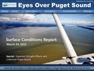
1. Eyes Over Puget Sound
Fieldlog Climate Water column Aerial photos Ferry andSatellite Moorings
Publication No. 15-03-072
Start here
Up-to-date observations of visiblewater quality conditions in Puget Sound and the Strait of Juan de Fuca
Surface Conditions Report
March 24, 2015
Special: Expected Drought Effects and
a Warmer Puget Sound
2. Personalfieldlog p.4
How was Puget Soundformed?
Climateconditions p.6
Air temperature andoceanconditions remainwarm. Rivers are
above normal,especially to the north. There has beenalmost
four inches (10 cm)of rainduring the past two weeks.
Watercolumn p.7
Starting inOctober,temperatures are the highest onour record
since 1989. Oxygenandsalinities are becoming lower.
Moorings p.38
Water aroundthe mooring continues to be warmer and
generally fresher thanpast several years. Seasonally,variability
of eachparameter remains minimal fromJanuary to March.
Aerialphotography p.10
Patches of jellyfishare still present infinger inlets of South
Sound. Water show signs of blooms only inconfined,stratified
bays. Otherwise,the surface waters are blue or carry dramatic
loads of suspendedsediment near rivers.
Ferryand satellite p.36
Isothermal conditions appear across Central Basinandthe
Straits withlittle signs of phytoplanktongrowth.
LONG-TERMMARINEMONITORINGUNIT
Mya Keyzers
Laura Hermanson
Brooke McIntyre
Skip Albertson
Dr. Christopher
Krembs
Julia Bos
Suzan Pool
Editorial assistance provided by: Julianne Ruffner, Suzan Pool, CarolMaloy
Marine conditionsfrom 3-24-2015 at a glance
Fieldlog Climate Water column Aerial photos Ferry andSatellite Moorings
Please give us feedback
Suzan Pool
Guest:
Dr. Brandon
Sackmann,
Integral
3. Expected drought effects and a warmer Puget Sound
Eyes Over Puget Sound
Publication No. 15-03-072
EOPS
Up-to-date observations of visiblewater quality conditions in Puget Sound and the Strait of Juan de Fuca
Special Report Insert:
Expected drought effects
and a warmer Puget Sound
March 24, 2015
Returnto Eyes over Puget Sound
Page 1 Page 2 Page 3 Page 4 Page 5 Page 6 Page 7 Page 8 Page 9 Page 10
4. Extreme low snowpack has triggered a drought
GovernorJay Inslee declared a drought on March 13 in three regions of Washington state. State law
allows Ecology to declare a drought emergencyif we determine that all or part of a geographical area
is suffering from drought conditions.
Snowpack is like a frozen reservoir
forriver basins, usually collecting
over the winter and then slowly
melting, providing a water supply for
rivers and streams.
Currently snowpack statewide is 26
percentof normal, with little to no
snowfall predicted into the spring,
and warmer-than-normal
temperatures through the summer.
Read the story on
Ecology’s website
Expected drought effects and a warmer Puget Sound
Page 1 Page 2 Page 3 Page 4 Page 5 Page 6 Page 7 Page 8 Page 9 Page 10
5. Record high winter temperatures mean rain, not snow
Although we’ve had plentiful precipitation, warm temperatures have pushed the snow line to high
elevations and reduced the snowpack in most areas. Some areas that are relatively cold, like the
North Cascades,have avoided this problem.
This year’s warm temperatures follow a long-term trend in warming.
Trends in PNW Climate
Climate change modeling
suggests that this winter’s
weather conditions,
although extreme compared
to the historical record, will
become more commonin
the future.
Future Northwest Climate
Expected drought effects and a warmer Puget Sound
Page 1 Page 2 Page 3 Page 4 Page 5 Page 6 Page 7 Page 8 Page 9 Page 10
6. Puget Sound Snow Pack
Conditions are extreme around the
Sound. All sites are below 50
% of normal, and some locations less
than 10% of normal.
Expected drought effects and a warmer Puget Sound
Page 1 Page 2 Page 3 Page 4 Page 5 Page 6 Page 7 Page 8 Page 9 Page 10
7. Four examples: snowpack tracking lowest on record
Expected drought effects and a warmer Puget Sound
Page 1 Page 2 Page 3 Page 4 Page 5 Page 6 Page 7 Page 8 Page 9 Page 10
8. Hurricane Ridge:
winter snow is gone.
Lowsnow has only occurred
twice since 1960
(1977 & 2005).
Expected drought effects and a warmer Puget Sound
April 2010
Feb2013
March2015
Photo by Bill Baccus,Olympic National Park
Page 1 Page 2 Page 3 Page 4 Page 5 Page 6 Page 7 Page 8 Page 9 Page 10
9. Low snowpack means low flows
Many of the major rivers draining to Puget Sounds are considered snowmelt-dominated.In these
systems,melting snowpack in the upper elevations maintains streamflows well into the summer
and recharges groundwater. Snowpack below normal means that low summer flows will begin
earlier and continue to drop below normal into the fall.
Encyclopediaof Puget Sound:
Section5. Seven-Day Low Flow
Basins moststrongly affected have high
elevation headwaters and no reservoirs.
Examples include:
•Dungeness River
•Nooksack River
•SnohomishRiver
Northwest River ForecastCenter
Flow Volume Projections
as percent of normal
Expected drought effects and a warmer Puget Sound
Page 1 Page 2 Page 3 Page 4 Page 5 Page 6 Page 7 Page 8 Page 9 Page 10
10. Low flows can harm salmon
Hal Beecher of Washington Dept. of Fish and Wildlife:
Low snowpackand consequentsummerlow flow have a variety of
negativeeffects on salmonand trout in rivers flowing to PugetSound:
•Many species spendatleasta yeargrowing in upland waterbodies before going to sea. Lower
flows mean less space to live in and highertemperatures,so that fewer young fish go to the ocean
followinga dry summer,and fewerreturn as adults.
•When low flows extend into the upstream migration season,shallow watermay preventfish from
reachingtheirhome spawning grounds.High temperatures may havethe additionalimpactoflow
oxygen levelsand the spread of disease.
•Low flows may force salmon to spawn nearerthe middle ofthe riverchannel,so that subsequent
winterstorm and high flows may scourredds and kill eggs.
•Several species spawnin the spring. If low flow comes earlierthan normal,someeggs may be left
high and dry before the young can emerge to swim away.
•Mostocean-going salmonand trout migrate downstream in spring. Higherflows from spring
snowmeltusuallyhelp movethose fish.Low spring flows from low snowpack meansthey move
more slowly,putting them atgreaterrisk of predation.
Expected drought effects and a warmer Puget Sound
Page 1 Page 2 Page 3 Page 4 Page 5 Page 6 Page 7 Page 8 Page 9 Page 10
11. Low inflows affect Puget Sound
circulation and quality
•Modeling shows that lower summer inflows change
circulation and reduce net outflows.
•Slower summer circulation can decrease oxygen levels
in the Sound to lower than normal levels.
•Climate change modeling demonstrates the effectof
reduced inflows on the Sound. By 2070,circulation
changes from low flows will significantly reduce oxygen.
These reductions may be as large as reductions from
doubling the population in the Puget Sound watershed.
•EcologyReport:Puget Sound and the Straits
Dissolved OxygenAssessment- Impacts of Current and
Future Nitrogen Sources and Climate Change through
2070
Expected drought effects and a warmer Puget Sound
Page 1 Page 2 Page 3 Page 4 Page 5 Page 6 Page 7 Page 8 Page 9 Page 10
12. This information brought to you by:
•Paul Pickett, low flow trend indicator lead
•Markus Von Prause, water quality indicator lead
•MindyRoberts, Puget Sound modeling lead
•Tyler Burks, stream hydrology lead
•Jeff Marti, Water Resources drought policy lead
•Hal Beecher, WDFW fishery flow lead
Expected drought effects and a warmer Puget Sound
Page 1 Page 2 Page 3 Page 4 Page 5 Page 6 Page 7 Page 8 Page 9 Page 10
13. Personal Field Impression
Fieldlog Weather Water column Aerial photos Ferry andSatellite Moorings
Personal Field Impression
Fieldlog Climate Water column Aerial photos Ferry andSatellite Moorings
VashonGlacier is the last huge glacier that covered Puget
Sound and began to retreat14,000 year ago.
Deepchannels,
passages, andbays –
characteristic of glacial
fjords.
What is a glacier?
Let’s look at some glacial evidence inPuget Sound…
A mass of ice flowing like a very slow river
formed by the compaction of snow.
Howwas PugetSound Formed?
PugetSound is a glacial fjord that was carved by nearly mile-thick glaciers.
Sucia IslandGig Harbor and Fox Island
During the retreat, the
Vashon Glacier left
behind many clues in
the landscape.
14. Erratics –Largeboulders dropped by glaciers.
Glacial layers –Layersof sediment deposited by glaciers in many shoreline bluffs.
Glaciomarine drift –The mud, rocks, sand, silt, clay,
and gravelleft behind as glacial ice melted.
Photograph Credits: Brooke McIntyre 2014, Laura Hermanson 2014, http://www.openhousewhiterock.com/blog/entertainment/ever-been-to-white-rock-21,
http://gravelbeach.blogspot.com/2009_10_01_archive.html , https://evstnaturalhistory.files.wordpress.com/2011/05/bluff.jpg, http://www.ecy.wa.gov/programs/sea/pugetsound/tour/geology.html,
http://www.fhs.d211.org/departments/science/jadcock/glacier_webquest.htm, http://www.marlimillerphoto.com/faves110226-24.html
DiscoveryPark BluffFortEbey State Park
TulalipBay
CommencementBay
NearSan Juan Islands
Granite Erratic
White Rock, BC
Erratic in North
PugetSound
Personal Field Impression
Fieldlog Climate Water column Aerial photos Ferry andSatellite Moorings
15. Fieldlog Climate Water column Aerial photos Ferry andSatellite Moorings
Climateand natural influencesbefore 3-24-2015
Summary:
Air temperatures remain above
normal, continuing an 11-month trend.
Precipitation levels have increased
since January.
Sunshine has been intermittent for the
past week but above normal for the
winter (the inverse of cloud cover).
River flows are higher across the
Puget Sound region, especially to the
north. Normally, the precipitation
would be captured in the snowpack.
PDO remains in the warm phase and
upwelling is above normal.
lowerhigher expected No data
Climate and natural influences are conditions that influence our marine waters, including weather,
rivers, and the adjacent ocean (previously called Weather). For an explanation of the figure, see:
http://www.ecy.wa.gov/programs/eap/mar_wat/weather.html, page 26.
Anomalies
16. We use a chartered float
plane to access our
monthly monitoring
stations.
We communicate data and
environmentalmarine
conditions using:
1. MarineWater
ConditionIndex
(MWCI)
2. EyesOverPuget
Sound (EOPS)
3. Anomaliesand
sourcedata
Fieldlog Weather Water column Aerial photos Ferry andSatellite Moorings
Ourlong-termmarinemonitoringstationsinWashington
Starthere
Isl.
.
17. Physical conditionstracked in statistically historic context
Fieldlog Weather Water column Aerial photos Ferry andSatellite Moorings
Feb. 2015:
Higher Temperature! LowerOxygenLowerSalinity
Redboxesshow
thatthe water
measuredis
warmerthan
anyof our
measurements
since 1989.
Explore profiles
atall stations
Month
Conditions were dominatedby warmwater associatedwiththe NE Pacific Oceanwarmsurfaceanomaly.
Starting inOctober,temperatures are the highest onour recordsince 1989. Oxygenandsalinities are
becoming lower.
18. a) PacificDecadalOscillationIndex(PDO,temperature) (explanation)
b) UpwellingIndex(anomalies)(Upwelling,lowoxygen) (explanation)
c) NorthPacificGyreOscillationIndex(NPGO,productivity) (explanation)
Fieldlog Weather Water column Aerial photos Ferry andSatellite Moorings
Theoceanaffectswaterquality: OceanClimateIndices
NPGO(x10)
PDO/UpwellingIndex
Three-year running average of PDO, Upwelling, and NPGO indices scores
.
-25
-20
-15
-10
-5
0
5
10
15
20
25
-1.5
-1
-0.5
0
0.5
1
1.5
1945 1950 1955 1960 1965 1970 1975 1980 1985 1990 1995 2000 2005 2010 2015
Ocean boundaryconditions are no longer favorable for water qualityin Puget Sound: (a) water is warming
(PDO), (b) upwellingoflow oxygen and high nutrient ocean water is again increasing(UpwellingIndex),
and (c) higher surface productivityalongthe coast (NPGO) is falling. Where are we headingnext?
19. Is the food web changing in Puget Sound?
Follow the experts
WebEx
Hypothesis!
Increasesin
nitrate
concentrations
couldbe caused
by a top-down
controlon
phytoplankton
biomass.
Is Noctiluca
a visible
harbingerof a
food web
change?
Hypothesis for combining a series of recent observations
affecting energy and material transfer to higher trophic levels
Arechangesin highertropic levelspart of a story of the low food web?
20. Summary: Aerial photography3-24-2015
Patchesof jellyfish are still present in finger inlets of South Sound. Waters show signs of
bloomsonly in confined, stratified bays(East Sound, Saratoga Passage). Otherwise, the
surfacewaters appear blue or carry dramatic loads of suspended sediment near rivers.
Fieldlog Weather Water column Aerial photos Ferry andSatellite Moorings
Start here
Mixing andFronts:
Strong tides mobilize nearshore sediment and show dramatic
patternsof mixing of sediment-rich water in the San Juan
Islands.
Debris:
Mostly lines of foamand small debris (eelgrass) forming
along tidal fronts.
Visible blooms:
Green-brown: Saratoga Passage(Whidbey Basin)
Red-brown: EastSound (OrcasIsland)
Jellyfish:
Sizablejellyfish patches still persist in southern inlets of South
Sound (Totten, Eld, and Budd Inlets).BloomDebrisFront
Suspendedsediment:
Largesuspended sediment plumes fromriversall around San
Juan Islands, Rosario Strait, Bellingham Bay, and PortSusan.
Suspended sediment near beaches during strong outgoing
tide.
Plume
DOT andEcology collaborateonmonitoring
1
Tidal flat in Cultus Bay (Whidbey Island)
1 2 10 12 17 18
4 5 6 7 8 9 10 11 12 13 14
16 17 201918
1 2 5 13 17 18
7 8
21. Straitof
Juan de Fuca
San Juan Islands
Padilla Bay
Main Basin
Hood Canal
South Sound
Whidbey Basin
Fieldlog Climate Water column Aerial photos Ferry andSatellite Moorings
Observation Maps:
Afternoonflight,photos 6-20
Sunny,high visibility,locallywindy
and cloudy
Flight Information:
Morningflight,photos 1-5
Sunny,mild,high visibility,clouds
11
10
Aerial photography
and navigation guide
6
Centraland NorthSound
SouthSound
7
12
5
Flight route and fuelingstop
17
9
18
3
2
1
4
13
14
19
16
Tides (Seattle) Feet Stage
2:24 AM 4.13 L
8:11 AM 11.59 H
2:50 PM -0.36 L
9:39 PM 10.81 H
15
20
8
23. 2 NavigateAerial photography 3-24-2015
Fieldlog Climate Water column Aerial photos Ferry andSatellite Moorings
Long tidal front outlined by debris line.
Location: Oakland Bay(South Sound),9:54 AM.
DebrisFishpens
24. 3 NavigateAerial photography 3-24-2015
No noticeable activity.
Location: Mud Bay,Lopez Sound (San Juan Islands),11:21 AM.
Fieldlog Climate Water column Aerial photos Ferry andSatellite Moorings
25. 4 Navigate
Fieldlog Climate Water column Aerial photos Ferry andSatellite Moorings
Aerial photography 3-24-2015
Large sediment-richwater being upwelledby tidal currents.
Location: Bird Rocks (San Juan Islands),11:24 AM.
sediment
26. 5 NavigateAerial photography 3-24-2015
Fieldlog Climate Water column Aerial photos Ferry andSatellite Moorings
Large sediment-richwater coming out of Guemes Channel.
Location: OffFidalgo Head (San Juan Islands),11:25 AM.
sediment
boat
boat
27. Long tidal eddy carrying sediment.
Location: West of BlakelyIsland (San Juan Islands),12:08 PM.
6 NavigateAerial photography 3-24-2015
Fieldlog Climate Water column Aerial photos Ferry andSatellite Moorings
eddy
sediment
28. Distinct front between sediment-richwater and a red-brown bloom at entrance to East Sound.
Location: West of Obstruction Island (San Juan Islands),12:09 PM.
7 NavigateAerial photography 3-24-2015
Fieldlog Climate Water column Aerial photos Ferry andSatellite Moorings
sediment
Bloom
boat
29. Distinct front between sediment-richwater and a red-brown bloom at entrance to East Sound.
Location: West of Obstruction Island (San Juan Islands),12:11 PM.
8 NavigateAerial photography 3-24-2015
Fieldlog Climate Water column Aerial photos Ferry andSatellite Moorings
sediment
Bloom
30. Strong tidal currents outlined by fine suspended sediments show structures of turbulence and shear.
Location: Patos Island (San Juan Islands),12:19 PM.
9 NavigateAerial photography 3-24-2015
Fieldlog Climate Water column Aerial photos Ferry andSatellite Moorings
sediment
31. 10 NavigateAerial photography 3-24-2015
Strong tidal currents outlined by fine suspended sediments show structures of turbulence and shear.
Location: Lookingat GulfIslands in Canada (San Juan Islands),12:20 PM.
Fieldlog Climate Water column Aerial photos Ferry andSatellite Moorings
sediment
32. 11 NavigateAerial photography 3-24-2015
Sediment-richwater from the Nooksack River.
Location: East ofLummi Reservation (Bellingham Bay),1:27 PM.
Fieldlog Climate Water column Aerial photos Ferry andSatellite Moorings
sediment
Plume
33. Sediment-richNooksack River plume with internal waves and ship track.
Location: Bellingham Bay(Bellingham Bay),1:29 PM.
12 Navigate
Fieldlog Climate Water column Aerial photos Ferry andSatellite Moorings
Aerial photography 3-24-2015
Plume
boat
34. Front separating water from Bellingham Bay and Samish Bay.
Location: OffLarrabee State Park (Bellingham Bay),2:01 PM.
13 NavigateAerial photography 3-24-2015
Fieldlog Climate Water column Aerial photos Ferry andSatellite Moorings
sediment
Debris
35. Fine lines of sediment rich water being advected through large gullies without mixing.
Location: PadillaBay(North Sound),2:06 PM.
14 Navigate
Fieldlog Climate Water column Aerial photos Ferry andSatellite Moorings
Aerial photography 3-24-2015
sediment
sediment
ship
36. 15 Navigate
Fieldlog Climate Water column Aerial photos Ferry andSatellite Moorings
Mudflats with gullies and patches of eelgrass.
Location: From above Bay View, (Padilla Bay),2:08 PM.
Aerial photography 3-24-2015
37. 16 Navigate
Sediment-richwater entering the Swinomish Channel flowing southward.
Location: La Conner (WhidbeyBasin),2:11 PM.
Aerial photography 3-24-2015
Fieldlog Climate Water column Aerial photos Ferry andSatellite Moorings
sediment
Plume
38. 17 Navigate
Fieldlog Climate Water column Aerial photos Ferry andSatellite Moorings
Long front of the Skagit River crossing the entire bay.
Location: Skagit Bay(WhidbeyBasin),2:14 PM.
Aerial photography 3-24-2015
Debris
39. Plumes of a murky sediment-richwater showing different tidal fronts.
Location: Across from Warm Beach, Port Susan (WhidbeyBasin),2:47 PM.
18 Navigate
Fieldlog Climate Water column Aerial photos Ferry andSatellite Moorings
Aerial photography 3-24-2015
sediment
sediment
Debris
Debris
40. 19 Navigate
Fieldlog Climate Water column Aerial photos Ferry andSatellite Moorings
Plume of sediment-richwater near beach during outgoing tide.
Location: Stretch Island (Case Inlet),4:52 PM.
Aerial photography 3-24-2015
sediment
sediment
41. 20 Navigate
Sediment-richwater near beach during outgoing tide.
Location: Near Dougall Point on Harstine Island,Case Inlet (South Sound),4:53 PM.
Aerial photography 3-24-2015
Fieldlog Climate Water column Aerial photos Ferry andSatellite Moorings
sediment
sediment
42. NorthSound/SanJuan Islands
Date: 3-24-2015
CentralSound
Aerial photography observations in Central SoundQualitative aerial observer map during transit Navigate
Fieldlog Climate Water column Aerial photos Ferry andSatellite Moorings
5
6
10
9
11
12
4
7
8
13
15
17
14
18
Numbers on map refer to picture numbers for spatial reference
3 16
43. Date: 3-24-2015
Qualitative aerial observer map during transit
Numbers on map refer to picture numbers for spatial reference
Navigate
Fieldlog Climate Water column Aerial photos Ferry andSatellite Moorings
SouthSound
1
2
20
19
44. Legendto map annotations
Comments:
Maps are producedby observers during and
after flights. They are intendedto give an
approximate reconstructionofthe surface
conditions onscales that connect to and
overlapwithsatellite images inthe sectionthat
follows.
Debris:
Debris canbe distinguished into natural and
anthropogenic debris floating at the surface
sensu Moore andAllen(2000). The majority of
organic debris inPuget Soundis natural and
mixedwithdiscardedman-made pieces of
plastic,wood,etc. Fromthe plane,we cannot
differentiatethe quality of debris at the surface
andtherefore,call it for reasons of practicality
just “debris”.
S.L. Moore,M. J. Allen. 2000. Distribution of
Anthropogenicand Natural Debris on the
Mainland Shelf of the Southern California Bight.
Marine Pollution Bulletin,40(1): 83–88.
Navigate
Fieldlog Climate Water column Aerial photos Ferry andSatellite Moorings
45. Current Conditions:
Cold water from WhidbeyBasin moves into Puget
Sound at the Triple Junction;associated with
moderate levels of chlorophyll fluorescence.
Increased turbidityseen throughout the Strait of
Georgia.
23 March 201523 March 2015
Brandon Sackmann
Contact: bsackmann@integral-corp.com
Fieldlog Climate Water column Aerial photos Ferry andSatellite Moorings
Ferry and satelliteobservations3-24-2015
Starthere
Current Conditions:
Isothermalconditions appear across Central Basin
and the Straits with little signs of phytoplankton
growth.
46. A. Phytoplankton started to increase during a mild and sunny period in February, butconcentrationshave
dropped acrossthe main part of Central Basin and the Strait of Juan de Fuca.
B. Isothermalsurfacewater near 10.5 °C persists for more than a month.
Shipyard
TheVictoria Clipper IV carries sensors in its sea chest. The sensors allow us to get
surfacetransects of temperature, chlorophyll, salinity, and other bio-optical
measurements between Seattle and Victoria, BC twice per day.
Fieldlog Climate Water column Aerial photos Ferry andSatellite Moorings
Ferry and satelliteobservations3-24-2015
Shipyard
Maintenance
Maintenance
Maintenance
Maintenance
B.
A.
14 14 14 14
47. Mooring observationsand trends
03-12-2015 to 03-25-2015
Fieldlog Climate Water column Aerial photos Ferry andSatellite Moorings
2-6 m depth
Dissolvedoxygenis not
measured.
12-16 m depth
These plots show the
probability of
observationsover the
pasttwo-week period.
High probability shown in
warmcolors.
Left Panels: Density is
defined by salinity and
temperature.
Right Panel: Dissolved
oxygen concentration in
relation to salinity.
At the Mukilteo mooring,water properties appear somewhat influenced bysoutherlywinds and
river flows until mid-March. This is when a shift in wind direction mayhave contributed to lower
salinityand higher temperature,tidalheight,and river flows. Afterwards,trends in temperature
and salinitycoincide with changes in tidal height and wind speed,but not river flows.
Data are not available
for this time period.
Look for themnext
month.
48. Mooring observationsand trends
01-18-2015 to 03-24-2015
Fieldlog Climate Water column Aerial photos Ferry andSatellite Moorings
Click on icon to view real-time
data of the moorings
Our mooringstation in Mukilteo is located
in WhidbeyBasin near Everett. It is also
located at the transition between
Possession and CentralSounds at a depth
that is influenced bythe Skagit and
Snohomish river discharges,prevailing
winds,and tidal mixing.
As the largest regional contributor of
freshwater to Puget Sound,understanding
the timingand magnitude ofthe Skagit
River flow is important.
We present data ofdailymeans for the
past 31 days. Data are plotted in Pacific
Standard Time. Wind dataare from Paine
Field in Everett. River flow data are from
USGS.
49. Mooring observationsand trends
Mukilteo2010 to 2015
Fieldlog Climate Water column Aerial photos Ferry andSatellite Moorings
Pleasenote that data are provisional. Data are in GMT.
At the Mukilteo mooring,we use the near-bottom
sensor (12-16 m deep) to measure significant inter-
annual variabilityin temperature,salinity,and
dissolved oxygen.
Inter-annual variabilityis shown over a 5-year
period. All three variables showstrongseasonality.
Water around the mooringcontinues to be warmer
and generallyfresher than past several years. The
amount ofdissolved oxygen is roughlysimilar to
2010, 2011, and 2013.
Seasonally,variabilityofeach parameter remains
minimal from Januaryto March.
51. You maysubscribe or unsubscribe to the Eyes Over Puget Sound email listservby going to:
http://listserv.wa.gov/cgi-bin/wa?A0=ECOLOGY-EYES-OVER-PUGET-SOUND
Many thanks to our business partners: Clipper Navigations,SwantownMarina,andKenmore Air.
We are looking forfeedbackto improve ourproducts.
Dr. ChristopherKrembs
christopher.krembs@ecy.wa.gov
Marine Monitoring Unit
EnvironmentalAssessment Program
WA Department of Ecology
Fieldlog Climate Water column Aerial photos Ferry andSatellite Moorings