
Recommended
More Related Content
Similar to EOPS_2020_09_28.pdf
Similar to EOPS_2020_09_28.pdf (20)
More from EOPS EOPS
Recently uploaded
Recently uploaded (20)
EOPS_2020_09_28.pdf
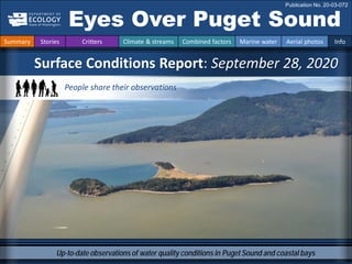
- 1. Up-to-date observations of water quality conditions in Puget Sound and coastal bays Surface Conditions Report: September 28, 2020 Eyes Over Puget Sound Publication No. 20-03-072 Summary Stories Critters Climate & streams Combined factors Marine water Aerial photos Info People share their observations
- 2. The Common Slipper Snail p. 4 Snuggle up and get comfortable with a little snail. Climate & streams p. 5-10 A relatively warm and dry summer leads up to a smoky September in the Puget Sound lowlands, followed by strong rain. People send their observations p. 11 Many great images illustrate that this summer, a lot of organic material was being produced, especially in Central Sound. The images speak for themselves: too much of a good thing can be an indication of eutrophication. Aerial photography p. 13-36 Following rain, river plumes are pronounced, especially near the Nooksack River. A few terminal bays still have red-brown blooms. Schools of fish are very abundant, and jellyfish that typically occur in fall are very sparse. LONG-TERM MARINE MONITORING UNIT Editorial assistance provided by: Elisa Rauschl, Julianne Ruffner, Valerie Partridge. Summary conditions at a glance Summary Stories Critters Climate & streams Combined factors Marine water Aerial photos Info Dr. Christopher Krembs (Editor) Tyler Burks Skip Albertson Dany Burgess Thank you to many
- 3. We now have a focused ocean acidification team! Personal Field Impression Summary Stories Critters Climate & streams Combined factors Marine water Aerial photos Info Personal Field Impression 9-28-2020 Natalie Coleman’s passion for marine science began by falling into a touch tank at the Monterey Bay Aquarium when she was 4. Since then, she worked at the Hatfield Marine Science Center and OSU, studied at Shannon Point Science Center and WWU, and is also our new boat pilot-in-training. Micah Horwith joined us in 2019 as Ocean Acidification Senior Scientist. CO2 emissions are changing the chemistry of Washington waters. Micah is focused on understanding how oysters, crabs, and other animals will respond, and what we can do to protect them. He received his Ph.D. in Biology from the University of Washington in 2011. Her favorite sea slug is Acanthodoris nanaimoensis. His favorite sea slug is Melibe leonina
- 4. Critter of the Month – The Common Slipper Snail Common Slipper Snail Facts • Forms stacked colonies called “chains” • Has an amazing reproductive strategy that you have to see (or at least read about) to believe! Crepidula fornicata Snuggle up and get comfortable with this month’s critter: a little snail that made it all the way to Puget Sound from the east coast. This species may look slipper-like, but it does so much more than just bear the name of our favorite practical footwear. Photo by Angela Johnson, ECY Photo by Ecomare, from Wikimedia Commons Summary Stories Critters Climate & streams Combined factors Marine water Aerial photos Info Eyes Under Puget Sound 9-28-2020 Learn more about the Common Slipper Snail and other critters on Ecology’s EcoConnect blog here Dany Burgess
- 5. How much water did we get and what can we expect? Summary Stories Critters Climate & streams Combined factors Marine water Aerial photos Info During the previous 30 days, Puget Sound air temperatures and precipitation were generally above normal (A). During the next 30 days, temperature forecasts are mixed, while precipitation is expected to be above normal (B). Through the end of the year, both temperature and precipitation have a higher probability to be above normal. A. Northwest Climate Toolbox (Previous 30 days) B. Climate Prediction Center, NOAA Temperature Anomaly from historical mean ranged from 0 to +4°F in the Puget Sound region during the past 30 days. Precipitation Anomaly from historical mean ranged from -2 to +5 inches in the Puget Sound region during the past 30 days. Temperature Precipitation October 2020 Oct-Nov-Dec2020 Precipitation Temperature The maps on the top show higher probability of above-normal precipitation in the NW. The maps on the bottom show a higher probability of higher temperatures in the NW, click here.
- 6. Daily average discharge, in cubic feet per second Select Puget Sound Streamflow Trends Daily average discharge, in cubic feet per second Current Streamflow Conditions as of 9/28/2020 Current conditions: CLICK HERE! USGS WaterWatch: CLICK HERE! Skagit River near Mt. Vernon (12200500) Snohomish River near Monroe (12150800) Puyallup River at Puyallup (12101500) How much water flows into Puget Sound? Summary Stories Critters Climate & streams Combined factors Marine water Aerial photos Info Following relatively normal streamflows in summer, precipitation from a strong atmospheric river increased freshwater inputs to Puget Sound quickly to above normal (trend charts, left). Rainfall during these 72-hour equaled volumes typically seen for the entire month of September and above normal streamflows were observed following the event (map, right). Expect varying conditions until the return of regular precipitation.
- 7. Large wildfires along the west coast brought much smoke to the region. What else did we get that was unexpected? Summary Stories Critters Climate & streams Combined factors Marine water Aerial photos Info Air quality and visibility were very low in the Puget Sound region during September because of wildfire-related smoke. This can lower air and water temperatures and may affect other aspects of water quality. NASA, 09-14-2020
- 8. Climate : How well is the Salish Sea exchanging its water? The Fraser River is the major driver of estuarine circulation and water exchange between the Salish Sea and the ocean. The Fraser River was flowing consistently high this year. Historically, the peaks of coastal upwelling and the freshet are in sync. In early 2020 Fraser R. flows were at expected levels. NPGO (x10) PDO/Upwelling Index How do ocean boundary conditions affect the quality of water we exchange with the ocean? Recent years’ warm water is mostly gone (PDO). Upwelling (Upwelling Index anomaly) is relatively expected. NPGO, which reflects the surface productivity along the coast, has fallen to one of its lowest numbers. Pacific Decadal Oscillation Index (PDO, temperature, explanation). Upwelling Index (anomalies) (Upwelling, low oxygen, explanation). North Pacific Gyre Oscillation Index (NPGO, productivity, explanation). Three-year running average of PDO, Upwelling, and NPGO Indices Summary Stories Critters Climate & streams Combined factors Marine water Aerial photos Info Fraser River (at midnight)
- 9. Climate: How well is Puget Sound exchanging its water? The Skagit River freshet is no longer clearly pronounced, because it is a regulated system. However, drought years and low flows can be seen in the river’s discharge data. This year, flows of the Skagit were close to normal. The Skagit River is the largest freshwater source for Puget Sound. It is a river that is regulated. Summary Stries Critters Climate & streams Combined factors Marine water Aerial photos Info River flows and upwelling in the summer influence our water quality. Rivers strengthen estuarine circulation in the Salish Sea. This is important in the summer. Upwelled ocean water provides cool, nutrient-rich water. For that to happen, we need northerly winds and good river flows (a good snowpack) during periods of water-exchange through Admiralty Reach (neap tides). Normal river flows drive “natural” nutrient inputs and keep the water cool. Low river flows change the nutrient balance and make water warmer. Skagit River (at midnight USGS) Higher than normal Lower than normal Expected
- 10. higher No data lower expected *Upwelling/downwelling Anomalies (PFEL) PDO = Pacific Decadal Oscillation ENSO = El Niño Southern Oscillation All data are from public sources: UW GRAYSKIES; river flows from USGS and Environment Canada; indices from NOAA & UW (PDO). Combined factors influencing water quality Summary Stories Critters Climate & streams Combined factors Marine water Aerial photos Info In the anomaly plot, we want to connect different factors influencing water quality in the context of space and time. We do this with a heat map and anomalies by month for selected regions from north to south. The past year has generally been warmer and drier. For recent river and stream inflow, see page 5. Conditions leading up to September: Air temperatures have generally been warmer this summer, except in June and July. Precipitation was mostly below normal, except in May and June Sunshine (opposite of cloud cover) levels have largely been higher in August. River flows have been expected, except for the higher flows in the Nisqually and Fraser rivers. Upwelling started in early spring during 2020, as in 2018 & 2019. La Nina is gaining strength.
- 11. Navigate Summary Stories Critters Climate & streams Combined factors Marine water Aerial photos Info A big thank-you to people contributing their observations Noctiluca blooms (June and August), pages 13, 14. Central Sound, Holmes Harbor, Chuckanut Bay, and Saddleback Island. Red-brown bloom of Protoceratium (July), page 16. Case Inlet, especially in the north. Mucus and decaying organic material (August and September): In Central Sound from Redondo Beach to Edmonds, pages 17, 18. Decaying shellfish (September): In Carr Inlet, Burley Lagoon, page 19. Bright green bloom in Bowman Bay (July), page 15. We are grateful for the wonderful contributions from so many People who shared their observations on the water with us. EOPS was suspended from April to August due to COVID-19. We could not have had this EOPS without you!
- 12. Central Basin, King County, Marine Monitoring program, 6/10/2020: “We have a ton of Noctiluca in our samples, >1000 cells per L, which is a lot for Central Basin “(Gabriella Hannach). Des Moines Marina, 6/7/20 (Robin Beck) Three Tree Point, 6/7/2020 (Elisa Rauschl) Lincoln Park 6/10/2020 (Ben Budka) Holmes Harbor, 6/16/2020 (Christine Goodwin) Off Redondo Beach, 8/25/2020 (Cliff Coombe) Noctiluca is a putative eutrophication indicator that thrives when excess organic material is present. Navigate Summary Stories Critters Climate & streams Combined factors Marine water Aerial photos Info People contribute their observations ①
- 13. Chuckanut Bay, Bellingham Bay, 8/4/2020 (Steve Tuckerman) Saddlebag Island, 8/11/2020 (Kathryn Sobocinski) Chuckanut Bay, Bellingham Bay, 8/4/2020 (Steve Tuckerman) Noctiluca is a putative eutrophication indicator that thrives when excess organic material is present. Navigate Summary Stories Critters Climate & streams Combined factors Marine water Aerial photos Info People contribute their observations ②
- 14. Bowman Bay, 7/16/2020 (Julie Morse) Bowman Bay, 7/16/2020 (Julie Morse) Algae blooms can come in all colors. Bright yellow-green blooms occasionally occur in some bays. Navigate Summary Stories Critters Climate & streams Combined factors Marine water Aerial photos Info People contribute their observations ③
- 15. Allyn-Grapeview, Case Inlet, 7/29/2020 (Michael Joffe) Sound Toxins: Case Inlet had a wide-spread bloom of Protoceratium reticulatum which started in the middle of June. Bloom was stronger in the north end of Case Inlet all the way south to Joemma State Park and to the Harstine Island bridge (Teri King) Blooms can persist for a long time, as was the case this year in Case Inlet. Fish perhaps benefit from it. Navigate Summary Stories Critters Climate & streams Combined factors Marine water Aerial photos Info People contribute their observations ④
- 16. Redondo 9/1/2020 (Cliff Coomber) Dash Point State Park, 8/30/2020 (Katharine Ellingson) Redondo 9/1/2020 (Cliff Coomber) Sound Toxins monitors determined it was mucus and dead plankton with active Akashiwo, prorocentrum, lazy pleurosigma, striatella and Nematodiums. When organic material and debris from excessive amounts of algae die, it washes onshore as mucus. Navigate Summary Stories Critters Climate & streams Combined factors Marine water Aerial photos Info Tramp Harbor Docton, 8/27/2020 (Karlista Rickerson) People contribute their observations ⑤
- 17. Edmonds 8/17/2020 (unknown) Navigate Summary Stories Critters Climate & streams Combined factors Marine water Aerial photos Info Edmonds underwater park, 8/24/2020 (Tim Ellis ) Edmonds underwater park, 8/24/2020 (Tim Ellis ) Edmonds 8/17/2020 (unknown) Mucus and beach wrack can smother the system and often lead to smells emanating from decaying material People contribute their observations ⑥
- 18. Tens of thousands of clams on the surface of the beach Seaweed matting on top of nets Burley Lagoon, 9/3/2020, when the stench from dying organisms was unbearable (Karen McDonell) Typically, shellfish can bury deeper in the sediment to avoid heat stress at low tide during warm sunny days. Burley Lagoon experienced strong odors of decaying organisms that remained exposed to heat. Navigate Summary Stories Critters Climate & streams Combined factors Marine water Aerial photos Info People contribute their observations ⑦
- 19. Bloom Debris Front Plume Narrow Hammersley Inlet connecting Oakland Bay Mixing and fronts: Tidal eddy in Lopez Sound, tidal fronts, and fronts due to heavy rain and large river plumes. Debris: Some organic debris in Port Madison; otherwise little. Visible blooms: Red-brown blooms in terminal inlets and bays, typical for the season. Jellyfish and fish: Jellyfish very sparse and only seen in Dyes Inlet. Schooling fish, on the other hand, very abundant in Case Inlet, Hood Canal, and western side between Port Madison and Kingston. Suspended sediment: Sediment in suspension covering large regions in Bellingham Bay, and to a lesser extent Commencement Bay, following days of strong precipitation. Red-brownbloom in Port Gamble Following rain, river plumes are pronounced, especially near the Nooksack River. A few terminal bays still have red-brown blooms. Schools of fish are very abundant, and jellyfish that typical occur in fall are very sparse. Lion’s mane in Peale Passage, 7/28/2020 (Katie Remine) Start here Christopher testing N95 mask required on the flight Summary Stories Critters Climate & streams Combined factors Marine water Aerial photos Info What were the conditions at the surface on 9-28-2020?
- 20. Flight Strait of Juan de Fuca San Juan Islands Main Basin Whidbey Basin Sunny, little waves and wind, good visibility Flight Observations Aerial navigation guide South Sound Summary Stories Critters Climate & streams Combined factors Marine water Aerial photos Info Padilla Bay Tide data from 9/28/2020 (Seattle): Time Pred (ft) High/Low 05:11 AM 7.02 L 10:28 AM 10.26 H 05:37 PM 0.24 L 7 15 10 11 12 13 1 3 9 5 2 4 8 6 14 16 People observations ①②③④⑤⑥⑦ ③ ① ② ④ ⑤ ⑦ ⑥ ② ① ⑤
- 21. Red-brown bloom. Location: Budd Inlet (South Sound), 11:28 AM 1 Aerial photography 9-28-2020 Navigate Summary Stories Critters Climate & streams Combined factors Marine water Aerial photos Info boat shoal marker Bloom Priest Point Park
- 22. B. A. D. C. Red-brown bloom. Location: A. Butler Cove, B. West Bay, C. Gull Harbor, D. Priest Point Park, Budd Inlet (South Sound), 11:23 AM 2 Navigate Summary Stories Critters Climate & streams Combined factors Marine water Aerial photos Info Aerial photography 9-28-2020 boat shadow Bloom Bloom Bloom Bloom Debris 2:19 PM
- 23. Red-brown bloom and organic debris floating at surface. Location: Eld Inlet (South Sound), 11:29 AM 3 Navigate Summary Stories Critters Climate & streams Combined factors Marine water Aerial photos Info Aerial photography 9-28-2020 Bloom Cooper Point Flapjack Point Debris
- 24. Isolated red-brown bloom surrounded by schools of fish. Location: North Bay, Case inlet (South Sound) 11:47 AM 4 Navigate Summary Stories Critters Climate & streams Combined factors Marine water Aerial photos Info Aerial photography 9-28-2020 fish fish fish fish fish fish fish Bloom Allyn
- 25. B. A. A. Schools of fish near the surface, likely pushed up by low oxygen front, and B. internal waves. Location: Twanoh State Park, (Hood Canal), 11:58 AM 5 Navigate Summary Stories Critters Climate & streams Combined factors Marine water Aerial photos Info Aerial photography 9-28-2020 Twanoh State Park Twanoh State Park fish fish fish fish fish fish fish fish internal wave Rose Point Debris Debris
- 26. Red-brown blooms in patches. Location: A-B. Sinclair Inlet, C-D Dyes Inlet (Central Sound) 12:12 PM B. A. D. C. 6 Navigate Summary Stories Critters Climate & streams Combined factors Marine water Aerial photos Info Aerial photography 9-28-2020 boat boat Bloom Bloom Bloom ship Port Orchard Madrona Pt
- 27. 7 Navigate Summary Stories Critters Climate & streams Combined factors Marine water Aerial photos Info Aerial photography 9-28-2020 Tidal front and dark unexplained spots (fish submerged vegitation). Location: Foulweather Bluff (Central Sound), 12:26 PM boat ? ? boat Foulweather Bluff
- 28. Water mixing with bloom. Location: Sequim Bay (North Sound), 12:40 PM 8 Navigate Summary Stories Critters Climate & streams Combined factors Marine water Aerial photos Info Aerial photography 9-28-2020 Klapot Point PNNL Marine Science Laboratory marker Bloom
- 29. Two large tidal eddies with sediment-rich water. Location: Across Center Island, Lopez Sound (North Sound), 12:55 PM 9 Navigate Summary Stories Critters Climate & streams Combined factors Marine water Aerial photos Info Aerial photography 9-28-2020 Lopez Island eddy eddy boat boat
- 30. Red-brown bloom in Hale Passage, and sediment-rich plume of the Nooksack River in Bellingham Bay. Location: Hale Passage (North Sound), 1:09 PM 10 Navigate Summary Stories Critters Climate & streams Combined factors Marine water Aerial photos Info Aerial photography 9-28-2020 Bloom boat Plume Lummi Island
- 31. B. A. D. C. A-C. The Nooksack River plume covering a wide area. D. The sediment layer is thin, as seen in the ship wake. Location: Bellingham Bay (North Sound), 1:15 PM 11 Navigate Summary Stories Critters Climate & streams Combined factors Marine water Aerial photos Info Aerial photography 9-28-2020 Plume Plume Plume Plume ship Eliza Is Nooksack
- 32. Potentially schools of fish in sediment-rich water coming from the Skagit River South Fork. Location: Skagit Bay (Whidbey Basin), 1:27 PM 12 Navigate Summary Stories Critters Climate & streams Combined factors Marine water Aerial photos Info Aerial photography 9-28-2020 fish fish fish fish Plume
- 33. B. A. A. Plume of Whidbey Basin spanning across to Kingston. B. Schools of fish in the plume. Location: North of Kingston (Central Sound), 1:46 PM 13 Navigate Summary Stories Critters Climate & streams Combined factors Marine water Aerial photos Info Aerial photography 9-28-2020 Everett fish fish fish fish fish fish fish fish fish fish Plume Debris
- 34. Several large schools of fish around Point Jefferson. Location: Port Madison (Central Sound), 1:49 PM 14 Navigate Summary Stories Critters Climate & streams Combined factors Marine water Aerial photos Info Aerial photography 9-28-2020 fish fish fish fish fish Pt Jefferson
- 35. B. A. A. Sediment from the Puyallup River getting pulled into the Tacoma Narrows. B. Puyallup River plume. Location: Commencement Bay (Central Sound) 2:04 PM 15 Navigate Summary Stories Critters Climate & streams Combined factors Marine water Aerial photos Info Aerial photography 9-28-2020 Plume ship Mount Rainier
- 36. Red-brown bloom and several small fronts from small rivers. Location: Henderson Inlet (South Sound) 2:17 PM 16 Navigate Summary Stories Critters Climate & streams Combined factors Marine water Aerial photos Info Aerial photography 9-28-2020 Bloom Woodard Pt Park
- 37. Contact: Dr. Christopher Krembs Christopher.Krembs@ecy.wa.gov Marine itoring Unit Environmental Assessment Program Washington State Department of Ecology Subscribe to the Eyes Over Puget Sound email listserv. Many thanks to our business partners: Shannon Point Marine Lab (WWU), Swantown Marina, and Kenmore Air. Find past editions of EOPS on the next pages Summary Stories Critters Climate & streams Combined factors Marine water Aerial photos Info We have published 87 editions! Recommended Citation (example for September 2018 edition): Washington State Department of Ecology. 2018. Eyes Over Puget Sound: Surface Conditions Report, September 17, 2018. Publication No. 18-03-075. Olympia, WA. https://fortress.wa.gov/ecy/publications/documents/1803075.pdf. Find all previous Eyes Over Puget Sound editions at the end of this document.
- 38. Month_date_year, Publication No. 20-03-07X Month_date_year, Publication No. 20-03-07X September_28_2020, Publication No. 20-03-072 No coverage due to COVID-19 pandemic from April-September March_16_2020, Publication No. 20-03-071 Jan_10_2020, Publication No. 20-03-070 October_30_2019, Publication No. 19-03-076 September_12_2019, Publication No. 19-03-075 July_29_2019 Publication No. 19-03-074 June_4_2019, Publication No. 19-03-073 March_26_2019, Publication No. 19-03-072 February_21_2019, Publication No. 19-03-071 January_10_2019, Publication No. 19-03-070 November_6_2018, Publication No. 18-03-075 September_17_2018, Publication No. 18-03-074 July_16_2018, Publication No. 18-03-073 June_28_2018, Publication No. 18-03-072 May_22_2018, Publication No. 18-03-025 April_19_2018, Publication No. 18-03-071 Winter_2018, Publication No. 18-03-070
- 39. October_31_2017, Publication No. 17-03-073 August_28_2017, Publication No. 17-03-072 July_24_2017, Publication No. 17-03-071 June_6_2017, Publication No. 17-03-070 December_31_2016, Publication No. 16-03-079 November_22_2016, Publication No. 16-03-078 September_26_2016, Publication No. 16-03-077 August_24_2016, Publication No. 16-03-076 July_20_2016, Publication No. 16-03-075 June_27_2016, Publication No. 16-03-074 May_2_2016, Publication No. 16-03-073 April_6_2016, Publication No. 16-03-072 March_16_2016, Publication No. 16-03-071 February_8_2016, Publication No. 16-03-070 December_30_2015, Publication No. 15-03-080 December_14_2015, Publication No. 15-03-079 October_6_2015, Publication No. 15-03-078 September_21_2015, Publication No. 15-03-077 August_8_2015, Publication No. 15-03-076 July_6_2015, Publication No. 15-03-075
- 40. June_8_2015, Publication No. 15-03-074 April_29_2015, Publication No. 15-03-073 March_24_2015, Publication No. 15-03-072 February_17_2015, Publication No. 15-03-071 January_28_2015, Publication No. 15-03-070 December_30_2014, Publication No. 14-03-080 November_17_2014, Publication No. 14-03-079 October_29_2014, Publication No. 14-03-078 September_16_2014, Publication No. 14-03-077 August_18_2014, Publication No. 14-03-076 July_28_2014, Publication No. 14-03-075 June_23_2014, Publication No. 14-03-074 May_12_2014, Publication No. 14-03-073 April_21_2014, Publication No. 14-03-072 March_24_2014, Publication No. 14-03-071 February_4_2014, Publication No. 14-03-070 December_31_2013, Publication No. 13-03-081 November_21_2013, Publication No. 13-03-080 October_28_2013, Publication No. 13-03-079 September_11_2013, Publication No. 13-03-078
- 41. August_21_2013, Publication No. 13-03-077 July_15_2013, Publication No. 13-03-076 June_17_2013, Publication No. 13-03-075 May_20_2013, Publication No. 13-03-074 April_8_2013, Publication No. 13-03-073 Mar_25_2013, Publication No. 13-03-072 February_26_2013, Publication No. 13-03-071 January_15_2013, Publication No. 13-03-070 December_13_2012, Publication No. 12-03-081 November_8_2012, Publication No. 12-03-080 October_8_2012, Publication No. 12-03-079 September_11_2012, Publication No. 12-03-078 August_27_2012, Publication No. 12-03-077 July_31_2012, Publication No. 12-03-076 June_12_2012, Publication No. 12-03-075 May_14_2012, Publication No. 12-03-074 April_23_2012, Publication No. 12-03-073 March_19_2012, Publication No. 12-03-072 February_27_2012, Publication No. 12-03-071 January_30_2012, Publication No. 12-03-070
- 42. December_5_2011, Publication No. 11-03-082 November_15_2011, Publication No. 11-03-081 October_17_2011, Publication No. 11-03-080 September_12_2011, Publication No. 11-03-079 August_8_2011, Publication No. 11-03-078 July_6_2011, Publication No. 11-03-077 June_20_2011, Publication No. 11-03-076 June_6_2011, Publication No. 11-03-075 May_4_2011, Publication No. 11-03-074 April_27_2011, Publication No. 11-03-073