Unusually warm water temperatures continue in central and south Puget Sound. River flows remain lower than normal, especially the Fraser and Skagit rivers. Thus, with estuarine circulation much weaker, Puget Sound waters stay put. Mats of organic debris persist in Central Sound near Port Madison. Red-brown and brown blooms are now very strong in southern inlets and jellyfish patches are exceptionally numerous and large. Explore media coverage of unusual Puget Sound conditions including jellyfish.
EOPS_July_24_2017,
July had warm air temperatures, sunshine, and an abundant snowpack. Previous months had higher river flows (bringing freshwater) and weak upwelling (low delivery of saltier water) which resulted in very low salinities in Puget Sound, especially in the South Sound. Water temperatures are expected and warmer in Central Sound. Above normal sunshine has made Puget Sound biologically very active! Intense and unusual blooms color Hood Canal (coccolithophores) and south sound inlets. Large mats of organic material containing macro-algae drift at the surface. Many schools of fish are visible though jellyfish were absent.
Ecology Publication No. 17-03-071
EOPS_July_20_2016,
Through June, air temperatures and sunlight were higher than normal. Recent rain generally improved river flows. However, the Fraser river flow remains extremely low, reducing water exchange with the ocean. Water temperatures are still breaking records, yet dissolved oxygen levels are normal. Coastal bays are influenced by upwelling and exhibit lower oxygen and higher salinities. Puget Sound algae are thriving with blooms observed in many South Sound inlets. Macro-algae is seen piling up on beaches and drifting in Central Sound. Jellyfish smacks are numerous in Eld and Budd Inlets. Our fliers notice seals hanging out at the beach!
Ecology Publication No. 16-03-075
EOPS_June_5_2017,
Cooler and wetter conditions early in 2017 have set the stage for a favorable supply of freshwater. River flows are all above normal due to melting of the abundant snowpack from warmer May air temperatures. This is creating significantly fresher conditions in Puget Sound surface waters. Algae blooms are limited to some yellow-green blooms growing in bays near the Kitsap Peninsula and blooms near estuaries of the Skagit, Stillaguamish, and Puyallup Rivers. Red blooms are present in rivers feeding into Willapa Bay. Also see what is “blooming” in the sediments of Puget Sound.
Ecology Publication No. 17-03-070
EOPS_August_28_2017,
Warm air temperatures, abundant sunshine, and drier conditions persisted. River flows are lower in the north. Puget Sound waters are still fresher than in the past 17 years from the combination of abundant spring rain and weak upwelling bringing less salty water from the ocean. July upwelling was stronger, however. Warmer water temperatures are notable in parts of Central Sound, accompanied by large rafts of drifting macroalgae. Diverse blooms in colors of green, orange and red-brown are present in many inlets. Jellyfish abundance is lower this year. Find out how we assess if the benthos is changing.
Ecology Publication No. 17-03-072
EOPS_May_2_2016,
Spring air temperatures are higher - it has been sunny and dry. The snowpack is quickly disappearing as temperatures are up to 7 °F warmer at higher elevations. Snowmelt-fed rivers are running very high. How does this affect water quality in Puget Sound? A strong spring phytoplankton bloom extends across Puget Sound and the Strait of Juan de Fuca. Water temperatures are still higher than normal and jellyfish are already numerous in southern inlets. The high biological activity is causing organic material to drift at the surface and wash onto beaches. Do you know how fast a Sand Star can move?
Ecology Publication No. 16-03-073
EOPS_February_8_2016,
January air temperatures and precipitation were above normal as El Nino conditions prevail. This winter our snowpack is in much better shape, though we’ve lost some snow from the stint of warm weather. More rain and higher river flows have lowered salinities in Puget Sound and coastal bays. Nonetheless, water temperatures in Puget Sound remain at record-breaking highs. Jellyfish patches are numerous in finger inlets of South Sound and signs of phytoplankton blooms are visible in coastal bays. When conditions limit flying, Ecology’s research vessel gets the job done.
Publication No. 16-03-070
The ocean and air remain warm with sunshine and dry weather across the region. As a result, Puget Sound is a lot warmer going into the new year. Hood Canal is responding with temperatures warmer than previous measurements, breaking its low temperature stint. First signs of growing phytoplankton are coloring the water green. Patches of jellyfish are overwintering in finger inlets of South Sound. Tidal fronts and suspended sediment are visible amidst the stunning San Juan Islands scenery. A sediment-rich water mass is trapped in Rosario Strait. Check out the South Sound Estuarium and the many reasons we love Puget Sound!
A stunning view of a second large Noctiluca bloom captures the attention of many living near Puget Sound. Favorable conditions support several regional phytoplankton blooms. Red-brown blooms in Port Townsend, Discovery Bay and Bellingham Bay. Large algal mats or organic material particularly in Samish Bay. Jellyfish patches increasing in Budd, Totten and Eld Inlets.
Unusually warm water temperatures continue in central and south Puget Sound while Willapa Bay returns to expected water temperatures as a result of stronger coastal upwelling. Extensive mats of organic debris develop in many places, particularly in Central Sound overlapping with a fading Noctiluca bloom. King County confirms Noctiluca and shares plankton species information. Red-brown and brown blooms are going strong in southern inlets and around the San Juan Islands. Our inspiring WCC Intern gets on boats, into the air, and to the lab.
Puget Sound conditions are normalizing after seven months of lower oxygen. Calm, dry, cool, and foggy mornings abruptly changed on October 28 to sun and strong northerly winds. Red-brown blooms and abundant jellyfish in south Puget Sound inlets appeared as we flew to the coast. Blooms were still visible near ocean beaches and inner bays. Grays Harbor had abundant surface debris with green algae in North Bay. We spotted red-brown blooms in rivers and sloughs in Willapa Bay, as well as schooling fish near sandbanks. Many patches of suspended sediment appeared in shallow water unrelated to tidal currents and remain unexplained.
River flows are above normal and air temperatures are increasing slowly. The spring phytoplankton bloom is slow to develop with visible blooms limited to smaller bays such as Sequim and Bellingham Bays. Noctiluca observed in East Sound on Orcas Island, coinciding with high numbers of jellyfish. Debris lines are mostly confined to Hood Canal. Pockets of colder water observed in Central Sound and Hood Canal, likely from the colder, saltier conditions that developed during the winter in the northern regions. Oxygen is variable yet close to expected ranges. Sizable oil sheens were sighted in Gig Harbor and Carr Inlet.
EOPS_August_24_2016,
In July, conditions were normalizing, yet river flows remained lower, continuing into August. July also saw lower oxygen appearing in southern Puget Sound. By August, jellyfish are occurring in high numbers in Eld and Budd Inlet. South Puget Sound has Noctiluca drifting at the surface in large orange lines in many places and red-brown blooms widespread in finger inlets, as well as in Sinclair Inlet. Central Sound surface-water temperatures are high, still in the 60s, and algae are abundant. See what we are measuring to understand ocean acidification in Puget Sound.
Publication No. 16-03-076
A recent cold spell hits Puget Sound lowlands, interrupting this year’s warmer air temperatures. The warm ocean coincides with new maximum water temperatures observed throughout Puget Sound in October! Hood Canal’s higher dissolved oxygen and cold water anomalies are disappearing. November brings cold water from Whidbey Basin into Puget Sound with moderate levels of chlorophyll fluorescence. Abundant smacks of jellyfish in finger inlets of South Sound observed from our flight. Red-brown blooms remain strong in smaller bays of South Sound. Visible suspended sediments in the coastal estuaries from rain, wind, and waves. Playing in the water? Visit our BEACH program.
"Understanding the Carbon Cycle: Processes, Human Impacts, and Strategies for...MMariSelvam4
The carbon cycle is a critical component of Earth's environmental system, governing the movement and transformation of carbon through various reservoirs, including the atmosphere, oceans, soil, and living organisms. This complex cycle involves several key processes such as photosynthesis, respiration, decomposition, and carbon sequestration, each contributing to the regulation of carbon levels on the planet.
Human activities, particularly fossil fuel combustion and deforestation, have significantly altered the natural carbon cycle, leading to increased atmospheric carbon dioxide concentrations and driving climate change. Understanding the intricacies of the carbon cycle is essential for assessing the impacts of these changes and developing effective mitigation strategies.
By studying the carbon cycle, scientists can identify carbon sources and sinks, measure carbon fluxes, and predict future trends. This knowledge is crucial for crafting policies aimed at reducing carbon emissions, enhancing carbon storage, and promoting sustainable practices. The carbon cycle's interplay with climate systems, ecosystems, and human activities underscores its importance in maintaining a stable and healthy planet.
In-depth exploration of the carbon cycle reveals the delicate balance required to sustain life and the urgent need to address anthropogenic influences. Through research, education, and policy, we can work towards restoring equilibrium in the carbon cycle and ensuring a sustainable future for generations to come.
Diabetes is a rapidly and serious health problem in Pakistan. This chronic condition is associated with serious long-term complications, including higher risk of heart disease and stroke. Aggressive treatment of hypertension and hyperlipideamia can result in a substantial reduction in cardiovascular events in patients with diabetes 1. Consequently pharmacist-led diabetes cardiovascular risk (DCVR) clinics have been established in both primary and secondary care sites in NHS Lothian during the past five years. An audit of the pharmaceutical care delivery at the clinics was conducted in order to evaluate practice and to standardize the pharmacists’ documentation of outcomes. Pharmaceutical care issues (PCI) and patient details were collected both prospectively and retrospectively from three DCVR clinics. The PCI`s were categorized according to a triangularised system consisting of multiple categories. These were ‘checks’, ‘changes’ (‘change in drug therapy process’ and ‘change in drug therapy’), ‘drug therapy problems’ and ‘quality assurance descriptors’ (‘timer perspective’ and ‘degree of change’). A verified medication assessment tool (MAT) for patients with chronic cardiovascular disease was applied to the patients from one of the clinics. The tool was used to quantify PCI`s and pharmacist actions that were centered on implementing or enforcing clinical guideline standards. A database was developed to be used as an assessment tool and to standardize the documentation of achievement of outcomes. Feedback on the audit of the pharmaceutical care delivery and the database was received from the DCVR clinic pharmacist at a focus group meeting.
WRI’s brand new “Food Service Playbook for Promoting Sustainable Food Choices” gives food service operators the very latest strategies for creating dining environments that empower consumers to choose sustainable, plant-rich dishes. This research builds off our first guide for food service, now with industry experience and insights from nearly 350 academic trials.
Artificial Reefs by Kuddle Life Foundation - May 2024punit537210
Situated in Pondicherry, India, Kuddle Life Foundation is a charitable, non-profit and non-governmental organization (NGO) dedicated to improving the living standards of coastal communities and simultaneously placing a strong emphasis on the protection of marine ecosystems.
One of the key areas we work in is Artificial Reefs. This presentation captures our journey so far and our learnings. We hope you get as excited about marine conservation and artificial reefs as we are.
Please visit our website: https://kuddlelife.org
Our Instagram channel:
@kuddlelifefoundation
Our Linkedin Page:
https://www.linkedin.com/company/kuddlelifefoundation/
and write to us if you have any questions:
info@kuddlelife.org
UNDERSTANDING WHAT GREEN WASHING IS!.pdfJulietMogola
Many companies today use green washing to lure the public into thinking they are conserving the environment but in real sense they are doing more harm. There have been such several cases from very big companies here in Kenya and also globally. This ranges from various sectors from manufacturing and goes to consumer products. Educating people on greenwashing will enable people to make better choices based on their analysis and not on what they see on marketing sites.
Natural farming @ Dr. Siddhartha S. Jena.pptxsidjena70
A brief about organic farming/ Natural farming/ Zero budget natural farming/ Subash Palekar Natural farming which keeps us and environment safe and healthy. Next gen Agricultural practices of chemical free farming.
Willie Nelson Net Worth: A Journey Through Music, Movies, and Business Venturesgreendigital
Willie Nelson is a name that resonates within the world of music and entertainment. Known for his unique voice, and masterful guitar skills. and an extraordinary career spanning several decades. Nelson has become a legend in the country music scene. But, his influence extends far beyond the realm of music. with ventures in acting, writing, activism, and business. This comprehensive article delves into Willie Nelson net worth. exploring the various facets of his career that have contributed to his large fortune.
Follow us on: Pinterest
Introduction
Willie Nelson net worth is a testament to his enduring influence and success in many fields. Born on April 29, 1933, in Abbott, Texas. Nelson's journey from a humble beginning to becoming one of the most iconic figures in American music is nothing short of inspirational. His net worth, which estimated to be around $25 million as of 2024. reflects a career that is as diverse as it is prolific.
Early Life and Musical Beginnings
Humble Origins
Willie Hugh Nelson was born during the Great Depression. a time of significant economic hardship in the United States. Raised by his grandparents. Nelson found solace and inspiration in music from an early age. His grandmother taught him to play the guitar. setting the stage for what would become an illustrious career.
First Steps in Music
Nelson's initial foray into the music industry was fraught with challenges. He moved to Nashville, Tennessee, to pursue his dreams, but success did not come . Working as a songwriter, Nelson penned hits for other artists. which helped him gain a foothold in the competitive music scene. His songwriting skills contributed to his early earnings. laying the foundation for his net worth.
Rise to Stardom
Breakthrough Albums
The 1970s marked a turning point in Willie Nelson's career. His albums "Shotgun Willie" (1973), "Red Headed Stranger" (1975). and "Stardust" (1978) received critical acclaim and commercial success. These albums not only solidified his position in the country music genre. but also introduced his music to a broader audience. The success of these albums played a crucial role in boosting Willie Nelson net worth.
Iconic Songs
Willie Nelson net worth is also attributed to his extensive catalog of hit songs. Tracks like "Blue Eyes Crying in the Rain," "On the Road Again," and "Always on My Mind" have become timeless classics. These songs have not only earned Nelson large royalties but have also ensured his continued relevance in the music industry.
Acting and Film Career
Hollywood Ventures
In addition to his music career, Willie Nelson has also made a mark in Hollywood. His distinctive personality and on-screen presence have landed him roles in several films and television shows. Notable appearances include roles in "The Electric Horseman" (1979), "Honeysuckle Rose" (1980), and "Barbarosa" (1982). These acting gigs have added a significant amount to Willie Nelson net worth.
Television Appearances
Nelson's char
Summary of the Climate and Energy Policy of Australia
EOPS_2018_05_22.pdf
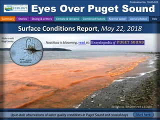
1. Des Moines, Saltwater Park 6-4-2018
Surface Conditions Report, May 22, 2018
Eyes Over Puget Sound
Publication No. 18-03-025
Up-to-date observations of water quality conditions in Puget Sound and coastal bays Start here
Summary Stories Diving & critters Climate & streams Combined factors Marine water Aerial photos Info
Noctiluca is blooming, read at:
Scale
39/10000 in
Photo credit
King County
2. Personal stories p. 2
What is that orange stuff out there? Find out.
Climate & Streams p. 5
Rain levels in May were in the top three lowest ever
recorded. Rivers responded differently whether they
received water from rain or snow.
With projected dryer and warmer conditions, can the
remaining snowpack maintain healthy streamflows this
summer?
Northwest Environmental Moorings p. 9
Meet the team and access real-time anomalies of Puget
Sound's mooring network. Yes, the seawater is getting
saltier in response to low rain.
Aerial photography p. 10
Many blooms in many colors. Large Noctiluca bloom on the
surface from South Sound to Central Sound and into
Whidbey Basin. Large accumulations of organic material in
many parts of Puget Sound and oil sheens east and west of
the Kitsap Peninsula.
LONG-TERM
MARINE
MONITORING
UNIT
Editorial assistance provided by: Allison Brownlee
Summary conditions at a glance
Skip Albertson
Dr. Christopher
Krembs (Editor)
Tyler Burks
Jim Shedd
Summary Stories Diving & critters Climate & streams Combined factors Marine water Aerial photos Info
Mya Keyzers
Allison Brownlee
Guest:
Northwest Environmental
Moorings group
3. The BEACH Program kicks off the 2018 season with a non-toxic algae bloom!
Noctiluca bloom at Saltwater State
Park, June 4 2018
Personal Field Impression
Personal stories and field impressions
Summary Stories Diving & critters Climate & streams Combined factors Marine water Aerial photos Info
• BEACH monitors saltwater beaches for fecal bacteria
• Weekly sampling to ensure water is safe for swimming and
recreational use
• Follow the BEACH team on Facebook and Twitter!
4. find number
May
1 16 92 8 8
2 11 20 4 7
3 16 39 15 98
4 48 89 6 3
5 20 97 12 3
6 34 98 8 10
7 23 75 12 8
8 30 82 17 7
9 36 80 9 7
10 21 15 7 43
11 32 98 15 5
12 28 92 3 23
13 34 94 3 3
14 11 7 7 46
15 18 62 14 21
16 17 98 12 20
17 17 36 15 94
18 19 25 3 3
Best and Worst horizontal visibility
and corresponding depth (ft)
# Best Worst
This is a new feature and we are soliciting feedback
(salb461@ecy.wa.gov). Eventually we will feature the most recent data.
Find depths with high/low visibility
• Best visibility was 48 feet in Saratoga
Passage and quite an improvement over
last month.
• Poor visibility occurred in Oakland Bay
(near Shelton), but also in Bellingham Bay.
• We use transmissometer readings from
our CTD package and convert them into
horizontal visibility. The poster,
Underwater Visibility Maps – a Tool for
Scuba Divers, is available at: Click here
good poor
visibility
What was the visibility in the water for divers?
What can you find underwater?
Summary Stories Diving & critters Climate & streams Combined factors Marine water Aerial photos Info
5. How much water flows into coastal marine waters?
Tyler Burks, Jim Shedd
Near record air temperatures and very low precipitation during the month of May has
resulted in highly variable freshwater inputs to Puget Sound by early June (map, center).
Rivers with headwaters at high elevation remained above normal, generally peaking early,
during the month of May due to rapid snowmelt (map panel, left), while low elevation rivers
declined steadily. Rivers that are fed by rainfall or that rapidly lost snowpack are now below
normal, while the remainder of rivers are flowing at near-normal levels.
Summary Stories Diving & critters Climate & streams Combined factors Marine water Aerial photos Info
Current Streamflow Conditions as of 6/11/2018
Snowpack Conditions May 1st & June 11th
Current conditions: CLICK HERE!
6. WA reservoir levels as are currently well above
average, though river flows have most recently
sharply dropped Click here
The maps on the top show higher probability of
below normal precipitation in the NW. The
maps on the bottom show a higher probability
of higher temperatures in the SW Click here
Climatologists predict drier and warmer conditions this summer. The dwindling La Niña is expected to
transition to ENSO-neutral. Will the current favorable snowpack translate to healthy stream flows in
September? WA reservoirs are still above average, that is good.
Jun 2018 July-Aug-Sep 2018
Precipitation
Temperature
How much water flows into coastal marine waters?
Summary Stories Diving & critters Climate & streams Combined factors Marine water Aerial photos Info
7. Climateinfluences:HowwellisPugetSoundexchangingits water?
The Fraser River is the major driver of
estuarine circulation and water
exchange with the ocean.
Fraser River flows are presently high
and the snowpack in BC is well above
100% (Basin Snow Water Index)
Historically, peaks of coastal upwelling and the freshet are in sync. Will they be this year?
NPGO
(x10)
PDO/Upwelling
Index
How do ocean boundary conditions
affect the quality of water we
exchange with the ocean?
Past years’ warm water is gone (PDO),
upwelling is neutral (Upwelling Index
anomaly), and surface productivity
along the coast is lower (NPGO).
Pacific Decadal Oscillation Index (PDO, temperature, explanation). Upwelling Index (anomalies) (Upwelling, low
oxygen, explanation). North Pacific Gyre Oscillation Index (NPGO, productivity, explanation).
Three-year running average of PDO, Upwelling, and NPGO indices
Summary Stories Diving & critters Climate & streams Combined factors Marine water Aerial photos Info
Higher than normal
Lower than normal
Expected
Fraser River
-25
-15
-5
5
15
25
-1.5
-1
-0.5
0
0.5
1
1.5
1945 1950 1955 1960 1965 1970 1975 1980 1985 1990 1995 2000 2005 2010 2015
8. What’s the story of influences affecting water quality?
higher No data
lower
expected
*Upwelling/downwelling Anomalies (PFEL)
PDO = Pacific Decadal Oscillation
NPGO = North Pacific Gyre Oscillation
ENSO = El Niño Southern Oscillation
Climate and natural influences include weather, river flows, and the adjacent ocean conditions
that affect our marine waters. This graphic provides context for interpreting Puget Sound marine
conditions. All data are from public sources: weather from UW GRAYSKIES; river flows from USGS
and Environment Canada; indices from NOAA, UW (PDO), and E. Di Lorenzo (NPGO).
Summary Stories Diving & critters Climate & streams Combined factors Marine water Aerial photos Info
Summary (May):
Air temperatures were above-
normal for May. SeaTac recorded
its warmest May ever, especially
overnight temperatures.
Precipitation levels were in the
top three lowest ever recorded.
Sunshine levels have been above
normal.
River flows were above normal,
especially to the north.
Upwelling was normal. ENSO
(MEI) was slightly positive,
indicating the end of La Niña.
9. About the Group: Using specialized oceanographic
moorings we design and build, we record long-term,
real-time measurements to track the health and
changes of coastal and inshore waters of the Pacific
Northwest.
http://nwem.ocean.washington.edu/prod_PS_Anomalies.shtml
Anomalies in Puget Sound in real-time
Look at the individual
moorings on the map
and click through to
view the products that
mooring produces.
click
How did water quality respond to recent conditions?
Summary Stories Diving & critters Climate & streams Combined factors Marine water Aerial photos Info
Northwest Environmental Moorings
10. What are conditions at the surface?
Start here
Bloom
Debris
Front
Plume
Narrow Hammersley Inlet connecting Oakland Bay
Mixing and Fronts:
Tidal fronts visible in Colvos Passage and Admiralty Inlet
Debris:
Abundant organic debris in South Sound, Northern Hood
Canal, Central Sound, Colvos Passage, and Saratoga Passage
Visible blooms:
Bright green: Mystery Bay, Oro Bay
Red-brown: Mystery Bay, Port Townsend Bay
Golden brown: Central Sound, Wollochet Bay
Orange green: Budd Inlet, Commencement Bay, Edmond,
Saratoga Passage
Jellyfish:
No visible jellyfish patches, instead lots of schooling fish in
Carr Inlet and Liberty Bay
Suspended sediment:
Suspended sediments entering with rivers is low
Many blooms in many colors. Large bloom in Central Sound supporting a large Noctiluca bloom
particularly in the south. Localized Noctiluca patches also in Budd Inlet and Saratoga Passage. Large
accumulations of organic material in other parts of South Sound, Whidbey Basin and northern Hood
Canal. Oil sheens east and west of the Kitsap Peninsula.
Summary Stories Diving & critters Climate & streams Combined factors Marine water Aerial photos Info
Oils sheen off Pilot Point, 6-4-2018
Lat 48.008269, Long -122.567856
Whale in the shallows, Saratoga Passage, 5-22-2018
Pilot Point
whale
oil sheen
11. Strait of
Juan de Fuca
San Juan Islands
Padilla Bay
Main Basin
Hood Canal
Whidbey Basin
1
Sunny and broken cloud ceiling.
Flight Information:
Aerial photography
and navigation guide
Flight routes
7
3
9
13
15
South Sound
Tide data from May 22, 2018 (Seattle):
Height (ft) High/Low
12:02 AM 11.75 H
6:29 AM 5.28 L
11:13 AM 8.07 H
5:35 PM 0.72 L
2
Summary Stories Diving & critters Climate & streams Combined factors Marine water Aerial photos Info
16
17
18
19
20
5
8
10
11
12
4
6
14
12. A. Noctiluca bloom surfacing near Priest Point Park, low altitude. B. At higher altitude.
Location: Budd Inlet (South Sound), 12:12 PM
Priest Point
A.
B.
1 Aerial photography 5-22-2018 Navigate
Summary Stories Diving & critters Climate & streams Combined factors Marine water Aerial photos Info
Priest Point
Bloom
Debris
Bloom
Debris
13. A. Aquaculture operations in Totten Inlet. B. Organic material accumulating along tidal fronts
Location: Henderson Inlet (South Sound), 12:21 PM
Hope Island
A. B.
2 Navigate
Summary Stories Diving & critters Climate & streams Combined factors Marine water Aerial photos Info
Aerial photography 5-22-2018
Squaxin
Island
Bloom
Debris
Front
sediment
14. Green and patchy bloom.
Location: Carr Inlet (South Sound), 12:33 PM
3 Navigate
Summary Stories Diving & critters Climate & streams Combined factors Marine water Aerial photos Info
Aerial photography 5-22-2018
South Head
McNeil Island
Bloom
15. Many patches of schooling fish
Location: A. near Allen Point, B. near Purdy Sand Spit (South Sound), 12:00 PM
Purdy Sand Spit
Allen Point
A. B.
4 Navigate
Summary Stories Diving & critters Climate & streams Combined factors Marine water Aerial photos Info
Aerial photography 5-22-2018
fish
fish
fish
fish
fish
fish
fish
fish
fish
fish
fish
fish
16. Many patches of schooling fish, bloom in olive-brown present A. At the entrance, and B. in Liberty Bay
Location: Keyport Lagoon (Central Sound), 12:03 PM
Keyport
B.
A.
Point Bolin
5 Navigate
Summary Stories Diving & critters Climate & streams Combined factors Marine water Aerial photos Info
Aerial photography 5-22-2018
Bloom
fish
fish
fish
fish
fish
fish
fish
fish
17. A. Red-brown bloom across Bishops Point. B. Yellow green bloom at the end of Scow Bay
A. Location: Marrowstone Island (Central Basin), 1:07 PM
Bishops Point
A. B.
6 Navigate
Summary Stories Diving & critters Climate & streams Combined factors Marine water Aerial photos Info
Aerial photography 5-22-2018
Bloom
Bloom
boat
18. 7 Navigate
Summary Stories Diving & critters Climate & streams Combined factors Marine water Aerial photos Info
Aerial photography 5-22-2018
Red-brown bloom and blue water entering through Portage Canal
Location: Port Hadlock (Central Basin), 1:08 PM
Port Hadlock
Bloom
Front
boats
19. A. Cloud formation likely due to colder water in Admiralty Reach. B. Organic material at tidal front
Location: A. Admiralty Reach, B. Whidbey Basin, (North Sound), 1:30 PM
Point Partridge
B.
A.
8 Navigate
Summary Stories Diving & critters Climate & streams Combined factors Marine water Aerial photos Info
Aerial photography 5-22-2018
Blowers Bluff
Rodena Beach
Debris
ship
20. A. Large ribbons of organic material, likely Noctiluca. B. Algal bloom extending north
Location: A. Saratoga Passage (Whidbey Basin), 1:44 PM
A. B.
9 Navigate
Summary Stories Diving & critters Climate & streams Combined factors Marine water Aerial photos Info
Aerial photography 5-22-2018
East Point
Camano Island
Bloom
Debris
Front
21. Strong algal bloom in main Basin contrasted against Colvos Passage water. A & B. tidal fronts
Location: Blake Island (Central Basin), 2:40 PM
A. B.
10 Navigate
Summary Stories Diving & critters Climate & streams Combined factors Marine water Aerial photos Info
Aerial photography 5-22-2018
Blake Island
Blake Island
Bloom
Front
Bloom
ferry
ferry
22. Mats of organic material accumulating along tidal fronts.
Location: Colvos Passage (Main Basin), 2:45 PM
Navigate
11
Summary Stories Diving & critters Climate & streams Combined factors Marine water Aerial photos Info
Aerial photography 5-22-2018
Command Point
Debris
boat
23. A. B.
Navigate
A. Green-yellow bloom of Noctiluca at entrance to Quartermaster Harbor, B. Bloom near Dockton
Location: Quartermaster Harbor (Central Basin), 2:50 PM
12
Summary Stories Diving & critters Climate & streams Combined factors Marine water Aerial photos Info
Aerial photography 5-22-2018
Neill Point
Dockton
Bloom
Debris
boat
Bloom
24. Navigate
Noctiluca bloom surfacing two weeks later and accumulating along tidal fronts
Location: North of Commencement Bay (Central Sound), 10:16 AM
13
Summary Stories Diving & critters Climate & streams Combined factors Marine water Aerial photos Info
Aerial photography 6-5-2018
Dash Point
Debris
Front
25. Noctiluca bloom surfacing two weeks later and accumulating along tidal fronts. Patchy sun light
Location: East of Maury Island (Central Sound), 10:16 AM
Navigate
14
Summary Stories Diving & critters Climate & streams Combined factors Marine water Aerial photos Info
Aerial photography 6-5-2018
Maury Island
Debris
26. Green-yellow bloom of Noctiluca with first signs of cells accumulating at the surface
Location: Commencement Bay (Central Basin), 2:55 PM
Navigate
15
Summary Stories Diving & critters Climate & streams Combined factors Marine water Aerial photos Info
Aerial photography 5-22-2018
Vashon Island
Bloom
Debris
ship
boat
boat
Front
27. Water leaving the Tacoma Narrows has minor algal blooms. Tidal fronts make contrast visible
Location: Point Defiance (Central Sound), 2:56 PM
Navigate
16
Summary Stories Diving & critters Climate & streams Combined factors Marine water Aerial photos Info
Aerial photography 5-22-2018
Point Defiance
Gig Harbor
Vashon Island
Bloom
Front
boat
boat
boat
28. Algal bloom at entrance to Wollochet Bay and Hale Passage
Location: Hale Passage (South Sound), 1:48 PM
Navigate
17
Summary Stories Diving & critters Climate & streams Combined factors Marine water Aerial photos Info
Aerial photography 5-22-2018
Cromwell
Fox Island
Cromwell
Bloom
Debris
Front
boat
29. A. Bloom leaving Carr Inlet. B. Organic material 14 days later 6-5-2018. C. Organic material off Sunset Beach
Location: South of the Tacoma Narrows (South Sound), 2:59 PM
A. B.
C.
Navigate
18
Summary Stories Diving & critters Climate & streams Combined factors Marine water Aerial photos Info
Aerial photography 5-22-2018
NcNeil Island NcNeil Island
Sunset Beach
Bloom
Debris
Debris
30. Yellow-green bloom in East Oro and Oro Bay
Location: Anderson Island (South Sound), 3:04 PM
Navigate
19
Summary Stories Diving & critters Climate & streams Combined factors Marine water Aerial photos Info
Aerial photography 5-22-2018
Jacobs Point
Bloom
Bloom
boat
31. Organic material floating south of Dana Passage
Location: Great Bend (South Sound), 3:09 PM
Navigate
20
Summary Stories Diving & critters Climate & streams Combined factors Marine water Aerial photos Info
Aerial photography 5-22-2018
Brisco
Point
Dover
Point
Squaxin
Island
Steamboat
Island
Debris
Front
boat
boat
32. Find past editions of EOPS with images on last pages
Summary Stories Diving & critters Climate & streams Combined factors Marine water Aerial photos Info
We have published 71 editions!
Recommended Citation (example from August 2017):
Washington State Department of Ecology. 2017. Eyes Over Puget Sound, Surface Conditions
Report, August 28, 2017. Ecology Publication No. 17-03-072.
https://fortress.wa.gov/ecy/publications/documents/1703072.pdf
Find all previous Eyes Over Puget Sound editions at the end of this document.
Contact:
Dr. Christopher Krembs,
ckre461@ecy.wa.gov
Marine Monitoring Unit
Environmental Assessment
Program
WA Department of Ecology
You may subscribe or
unsubscribe to the Eyes Over
Puget Sound email listserv by
going to:
http://listserv.ecology.wa.gov/scrip
ts/wa-ECOLOGY.exe?A0=ECOLOGY-
EYES-OVER-PUGET-SOUND
Many thanks to our business partners:
Shannon Point Marine Lab (WWU),
Swantown Marina, and Kenmore Air.