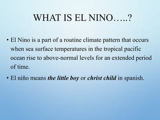
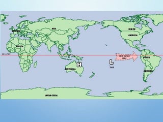
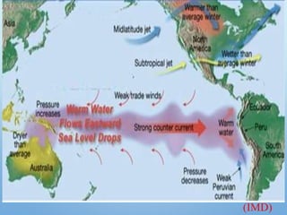
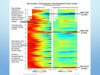
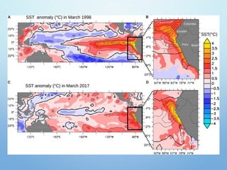
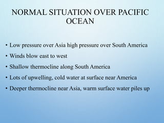
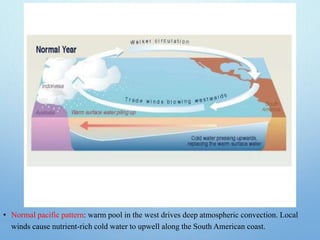
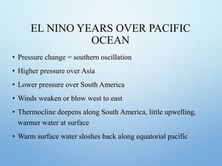
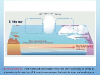
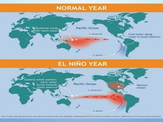
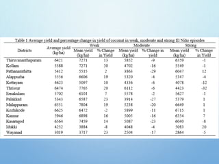
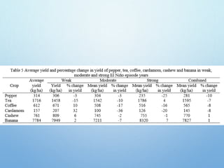
WELCOME
WHAT IS EL NINO…..?
• El Nino is a part of a routine climate pattern that occurs
when sea surface temperatures in the tropical pacific
ocean rise to above-normal levels for an extended period
of time.
• El niño means the little boy or christ child in spanish.
IN SIMPLE WORDS
WHEN & WHERE…?
INTERNATIONAL DATE LINE AND 120°W
• Occurs every 3 – 7 years although they appear to
be getting more regular
• Usually lasts about 1 year
• Warm water arrives at South America around
Christmas – hence El Nino –for the Christ child
NOAA
WHY…?
• Warmer water in the eastern pacific ocean.
• Low pressure in the eastern pacific ocean.
• El Niño results from interaction between the surface
layers of the ocean and the overlying atmosphere in
the tropical pacific.
• Trade winds lessen or reverse their direction
•
(NOAA)
HOW….?
• Winds from the west push warm surface water to the east in the
direction of the continent of South America.
• There is less cold water pulled up from below as a result of this
increase in warmer water.
• Weak Peruvian current and trade winds.
(IMD)
There are a few theories that surround it’s cause and here are few.
• Rossby wave - wave lowers thermocline in w. Pacific reducing the
upwelling of water. Winds then blow towards warmer water and event
starts.
• Tropical storms : if storms are strong enough they can blow water
eastwards and start the event.
• Heat from sea floor by sea floor volcanoes (no evidence)
NORMAL SITUATION OVER PACIFIC
OCEAN
• Low pressure over Asia high pressure over South America
• Winds blow east to west
• Shallow thermocline along South America
• Lots of upwelling, cold water at surface near America
• Deeper thermocline near Asia, warm surface water piles up
• Normal pacific pattern: warm pool in the west drives deep atmospheric convection. Local
winds cause nutrient-rich cold water to upwell along the South American coast.
EL NINO YEARS OVER PACIFIC
OCEAN
• Pressure change = southern oscillation
• Higher pressure over Asia
• Lower pressure over South America
• Winds weaken or blow west to east
• Thermocline deepens along South America, little upwelling,
warmer water at surface
• Warm surface water sloshes back along equatorial pacific
• El nino conditions: warm water and atmospheric convection move eastwards. In strong el
ninos deeper thermocline off S. America means upwelled water is warm and nutrient poor.
EFFECTS
AMERICA
• Upwelling along Peru
• Reduced cold water
• Fisheries decline
• Increased winter Jet streams, Hurricanes over western sides.
• Increased precipitation over parts of South America, western and
southern U.S.
• Above normal temp. in temperate zones of America
(Hussain. et.al)
Peru land sliding
Argentina flood
NOAA
ASIA AND AUSTRALIA
• Can result in severe flooding
• Death of Coral reefs
• Drought in Australia, Indonesia, Phillipines
• Reduction in annual monsoons in India
• Can result in severe crop damage
• Severe property damage and thousands of deaths
(Hussain. et.al)
• High mortality of seabirds in the islands of Pacific ocean.
• Increased case of malaria- S. America, Asia
• Increased frequency of tropical cyclones over Tahiti island.
• The 1982-83 el niño is estimated to have caused more than $10 billion
in weather-related damage worldwide.
• With 2014 and 2015 being two of the warmest years on record. Over
60 million people face hunger, malnutrition in 2016 due to drought
effects influenced by ENSO, with Africa worst hit, Indochina facing
severe drop in food production, and Ethiopia counting 10 million
people at risk.
• Over Indian subcontinent, el nino during winter results in development
of warm conditions. During summer, it leads to dry conditions and
deficient monsoon.
(Cook et al)
• In the recent past, India experienced deficient rainfall during el nino years 2002 and
2009 whereas monsoon was normal during el nino years 1994 and 1997. This so far
implies that in about 50 per cent of the years with el nino during summer, India
experienced droughts during monsoon.
• This implies that el nino is not the only factor that affects monsoon in India. There
are other factors that affect India’s rainfall pattern. These include North Atlantic SST,
equatorial SE Indian ocean SST, east asia mean sea level pressure, North Atlantic
mean sea level pressure and north central pacific wind at 1.5 km above sea level
FORECASTING
• To forecast an El Nino, scientists monitor temperatures in the
upper 656 feet (200 meters) of the ocean. They are watching for
the telltale temperature shift from the western pacific to the
eastern pacific. For example
• They often begin to form in spring, reach peak strength between
december and january, and then decay by may of the following
year.
• The sea-surface temperature is also about 14 degrees fahrenheit
(8 degrees celsius) warmer in the west.
El Nino effect
El Nino effect
El Nino effect
El Nino effect
El Nino effect
El Nino effect
El Nino effect
El Nino effect
El Nino effect
El Nino effect
El Nino effect
El Nino effect
El Nino effect
El Nino effect
El Nino effect
El Nino effect
El Nino effect

El Nino effect

  • 1.
  • 3.
    WHAT IS ELNINO…..? • El Nino is a part of a routine climate pattern that occurs when sea surface temperatures in the tropical pacific ocean rise to above-normal levels for an extended period of time. • El niño means the little boy or christ child in spanish.
  • 4.
  • 5.
    WHEN & WHERE…? INTERNATIONALDATE LINE AND 120°W
  • 6.
    • Occurs every3 – 7 years although they appear to be getting more regular • Usually lasts about 1 year • Warm water arrives at South America around Christmas – hence El Nino –for the Christ child NOAA
  • 7.
    WHY…? • Warmer waterin the eastern pacific ocean. • Low pressure in the eastern pacific ocean. • El Niño results from interaction between the surface layers of the ocean and the overlying atmosphere in the tropical pacific. • Trade winds lessen or reverse their direction • (NOAA)
  • 9.
    HOW….? • Winds fromthe west push warm surface water to the east in the direction of the continent of South America. • There is less cold water pulled up from below as a result of this increase in warmer water. • Weak Peruvian current and trade winds.
  • 10.
  • 13.
    There are afew theories that surround it’s cause and here are few. • Rossby wave - wave lowers thermocline in w. Pacific reducing the upwelling of water. Winds then blow towards warmer water and event starts. • Tropical storms : if storms are strong enough they can blow water eastwards and start the event. • Heat from sea floor by sea floor volcanoes (no evidence)
  • 14.
    NORMAL SITUATION OVERPACIFIC OCEAN • Low pressure over Asia high pressure over South America • Winds blow east to west • Shallow thermocline along South America • Lots of upwelling, cold water at surface near America • Deeper thermocline near Asia, warm surface water piles up
  • 15.
    • Normal pacificpattern: warm pool in the west drives deep atmospheric convection. Local winds cause nutrient-rich cold water to upwell along the South American coast.
  • 16.
    EL NINO YEARSOVER PACIFIC OCEAN • Pressure change = southern oscillation • Higher pressure over Asia • Lower pressure over South America • Winds weaken or blow west to east • Thermocline deepens along South America, little upwelling, warmer water at surface • Warm surface water sloshes back along equatorial pacific
  • 17.
    • El ninoconditions: warm water and atmospheric convection move eastwards. In strong el ninos deeper thermocline off S. America means upwelled water is warm and nutrient poor.
  • 20.
    EFFECTS AMERICA • Upwelling alongPeru • Reduced cold water • Fisheries decline • Increased winter Jet streams, Hurricanes over western sides. • Increased precipitation over parts of South America, western and southern U.S. • Above normal temp. in temperate zones of America (Hussain. et.al)
  • 21.
  • 22.
    ASIA AND AUSTRALIA •Can result in severe flooding • Death of Coral reefs • Drought in Australia, Indonesia, Phillipines • Reduction in annual monsoons in India • Can result in severe crop damage • Severe property damage and thousands of deaths (Hussain. et.al)
  • 23.
    • High mortalityof seabirds in the islands of Pacific ocean. • Increased case of malaria- S. America, Asia • Increased frequency of tropical cyclones over Tahiti island. • The 1982-83 el niño is estimated to have caused more than $10 billion in weather-related damage worldwide. • With 2014 and 2015 being two of the warmest years on record. Over 60 million people face hunger, malnutrition in 2016 due to drought effects influenced by ENSO, with Africa worst hit, Indochina facing severe drop in food production, and Ethiopia counting 10 million people at risk. • Over Indian subcontinent, el nino during winter results in development of warm conditions. During summer, it leads to dry conditions and deficient monsoon. (Cook et al)
  • 24.
    • In therecent past, India experienced deficient rainfall during el nino years 2002 and 2009 whereas monsoon was normal during el nino years 1994 and 1997. This so far implies that in about 50 per cent of the years with el nino during summer, India experienced droughts during monsoon. • This implies that el nino is not the only factor that affects monsoon in India. There are other factors that affect India’s rainfall pattern. These include North Atlantic SST, equatorial SE Indian ocean SST, east asia mean sea level pressure, North Atlantic mean sea level pressure and north central pacific wind at 1.5 km above sea level
  • 27.
    FORECASTING • To forecastan El Nino, scientists monitor temperatures in the upper 656 feet (200 meters) of the ocean. They are watching for the telltale temperature shift from the western pacific to the eastern pacific. For example • They often begin to form in spring, reach peak strength between december and january, and then decay by may of the following year. • The sea-surface temperature is also about 14 degrees fahrenheit (8 degrees celsius) warmer in the west.