Download to read offline


![GIality
GIality n. [jee-al-i-tee]
1. the convergence of geospatial data with
augmented reality technology
2. the integration of real-world sensors for attitude,
orientation, location and imagery with spatial data
and services to provide new 3D visualisation
tools for a mobile equipped workforce and public
@AGINorthGroup @linknode8](https://image.slidesharecdn.com/crispinhoult-131120091934-phpapp01/85/Geospatial-Data-for-Augmented-Reality-Crispin-Hoult-9-320.jpg)


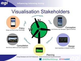


This document discusses using geospatial data and augmented reality technology together. It provides examples of augmented reality being used with location data and maps for applications in utilities, heritage, architecture, planning and entertainment. The document also describes a case study of using these technologies for public consultation during wind farm planning by allowing stakeholders to visualize proposed developments in an immersive way. It argues that augmented reality can make geospatial data more flexible and accessible compared to traditional static maps.


