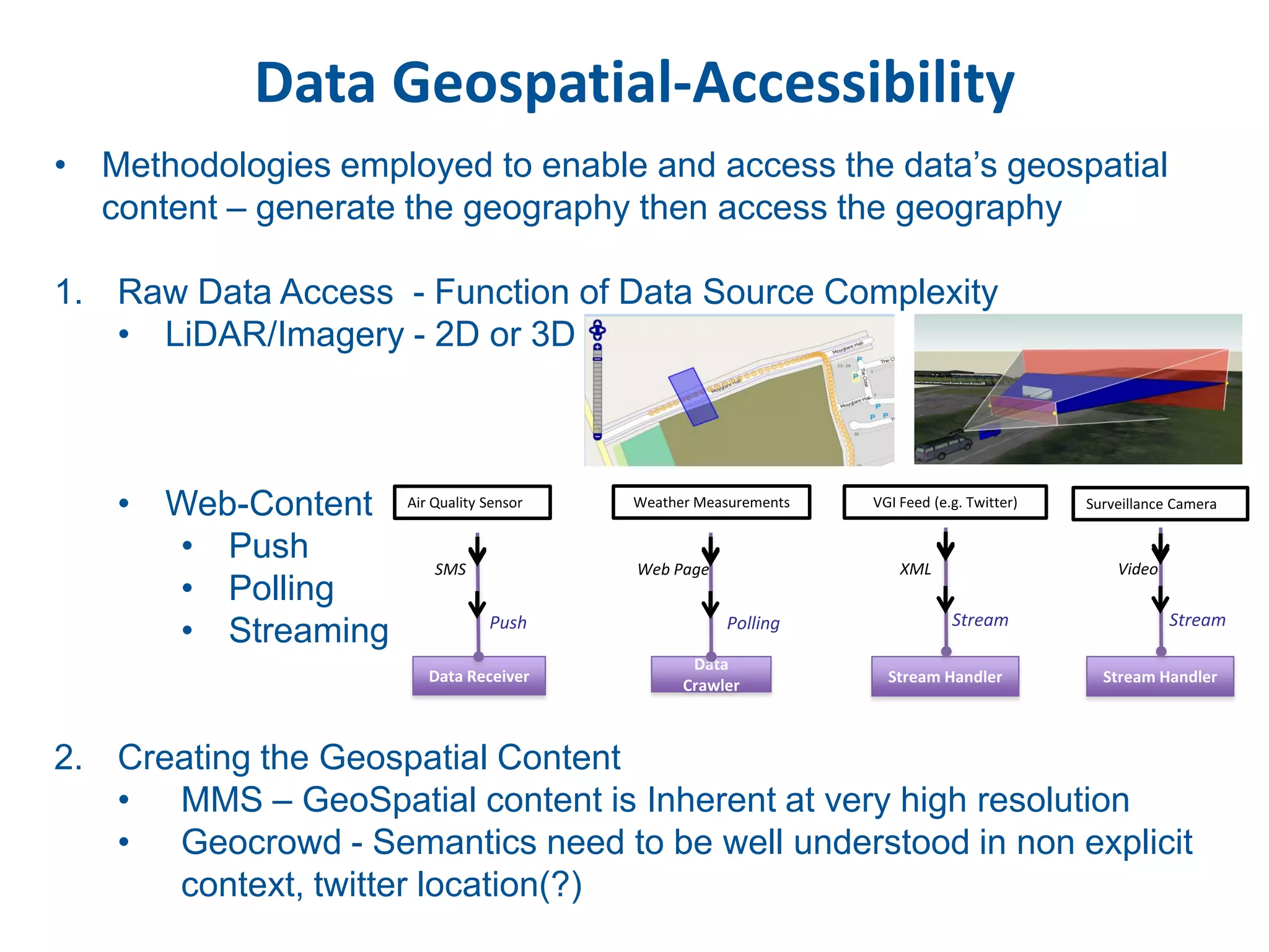
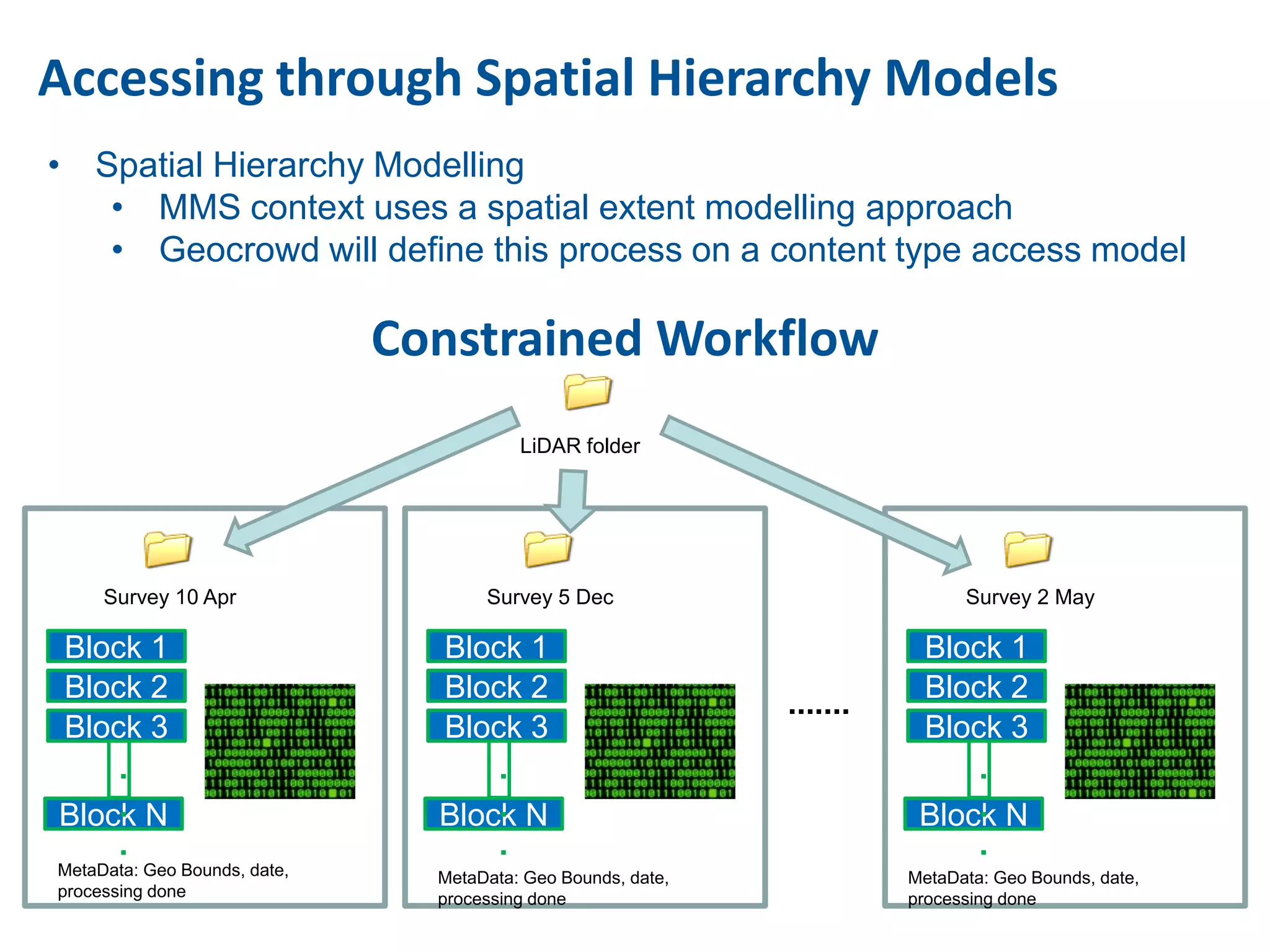
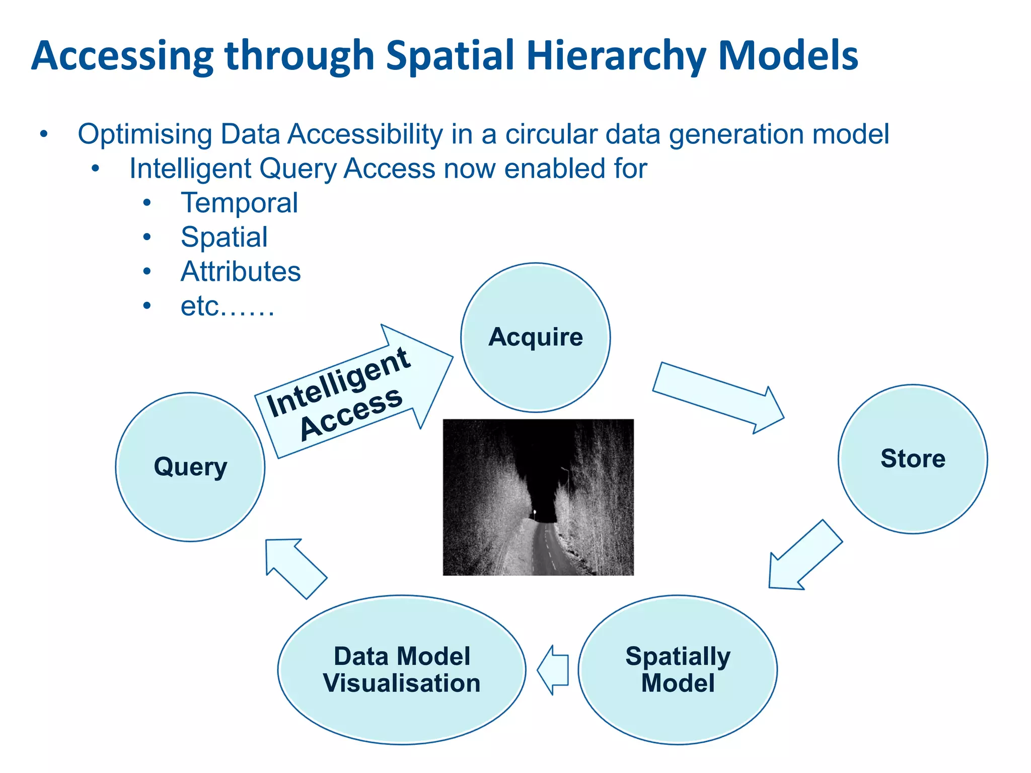
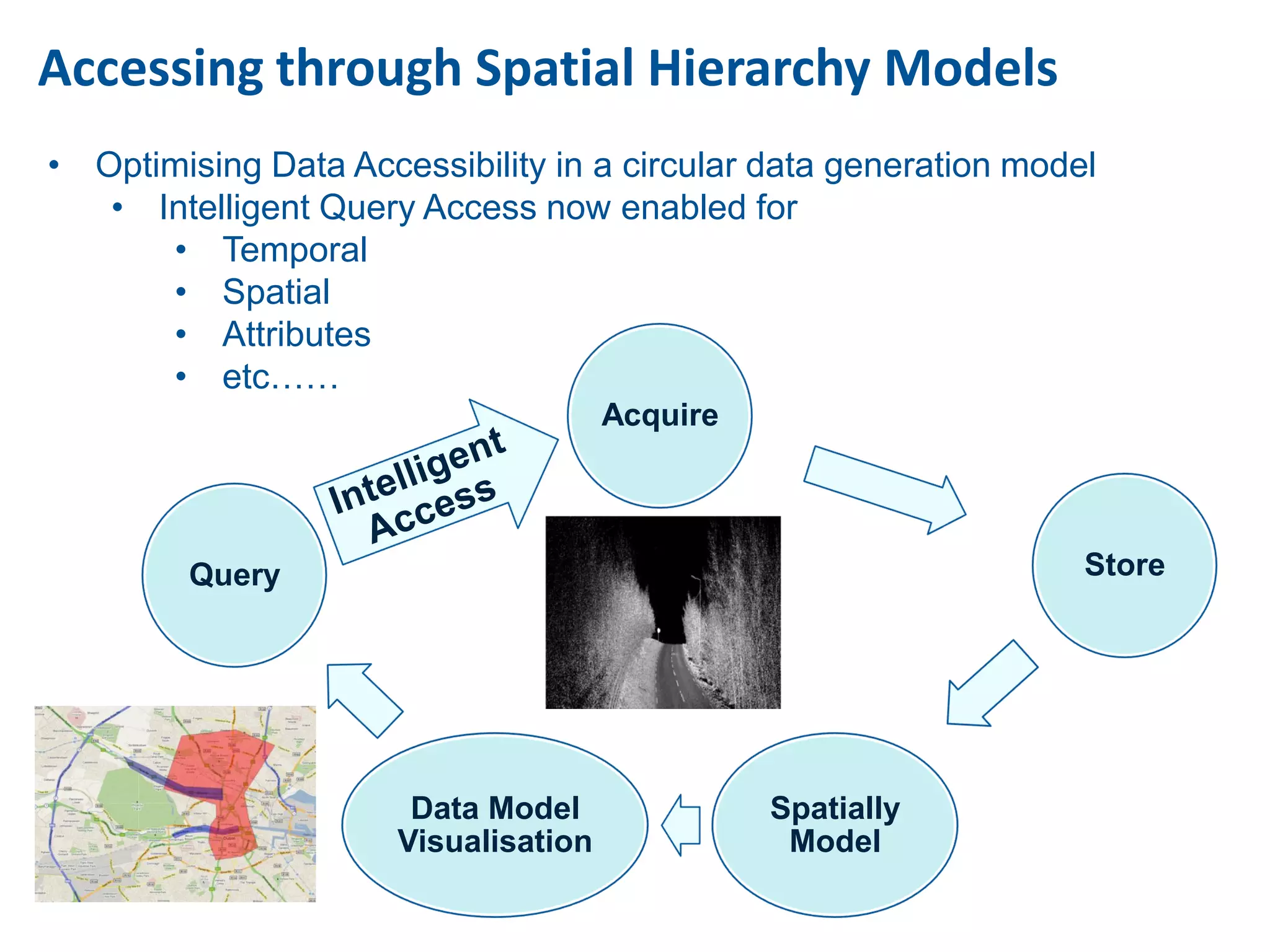
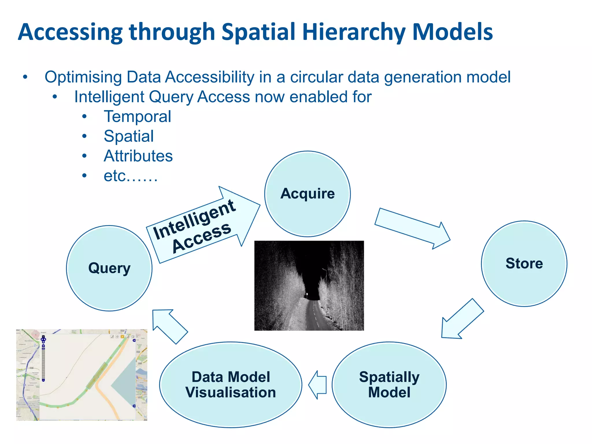
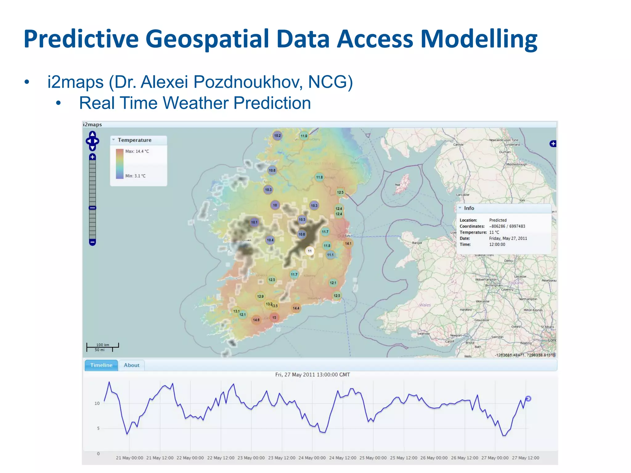
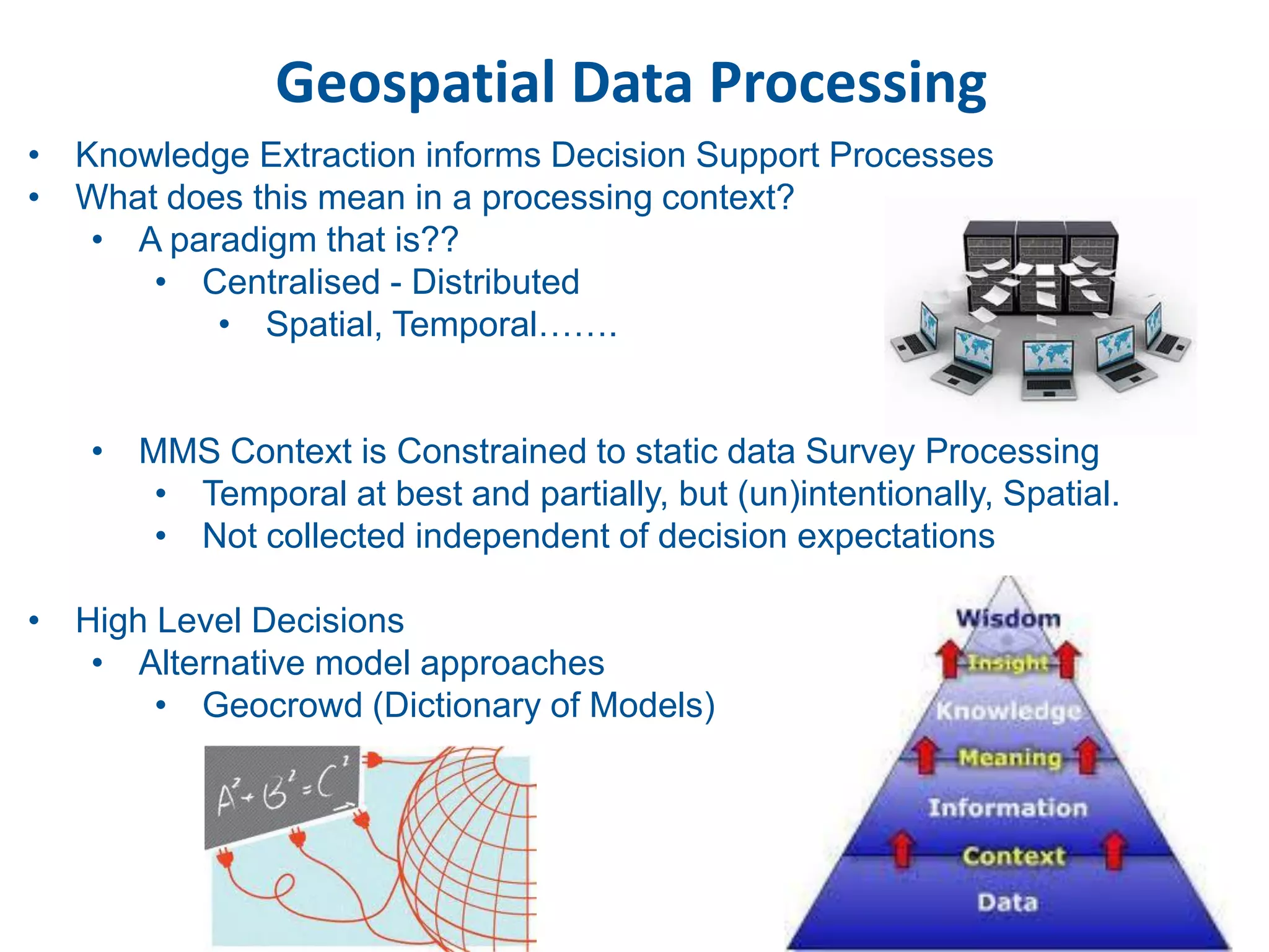
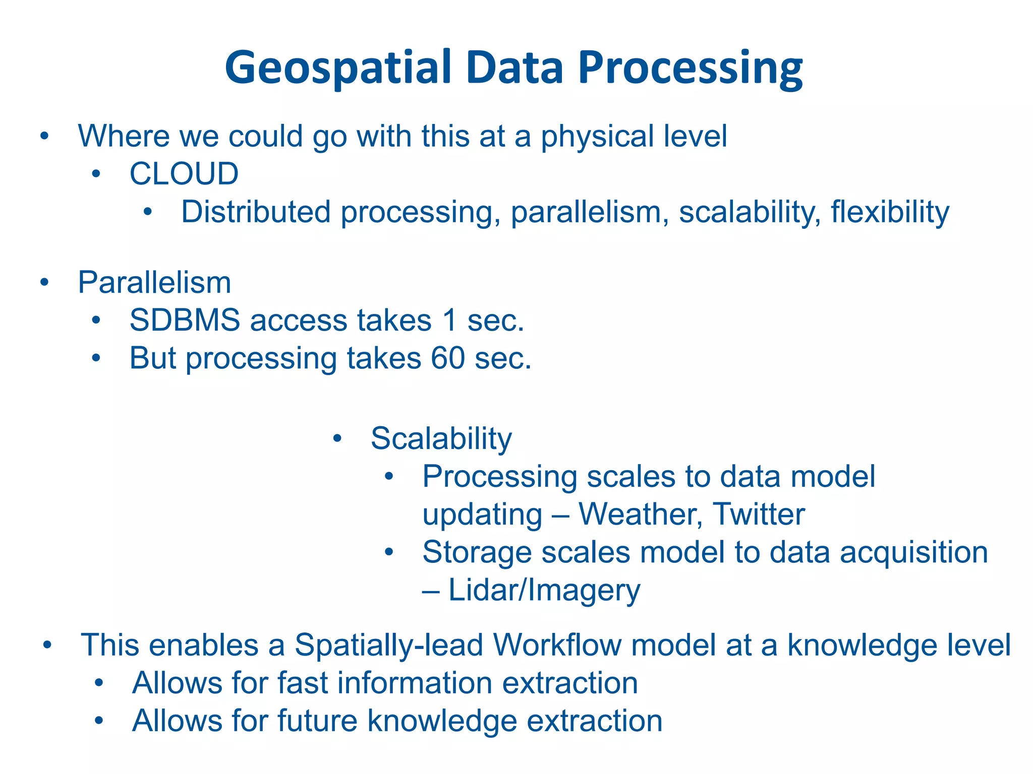
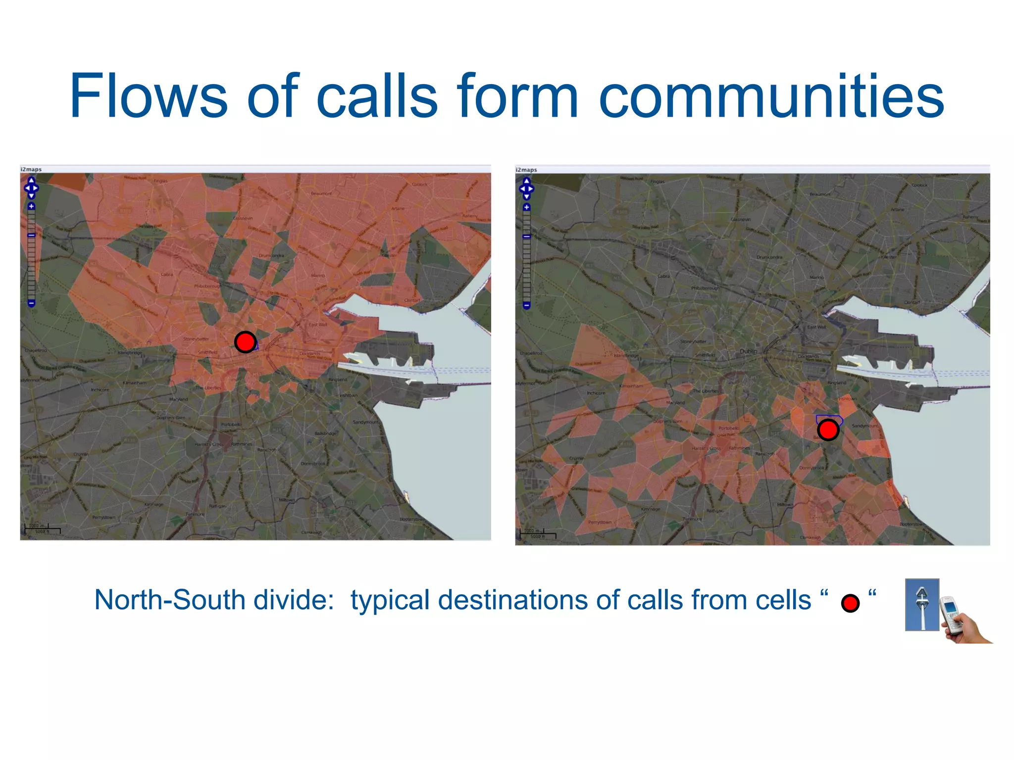
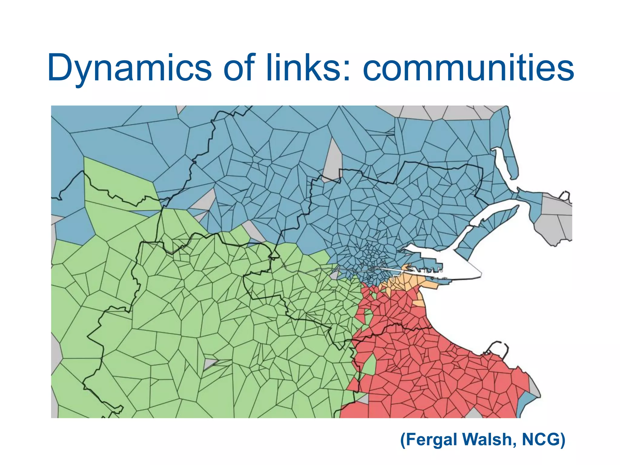
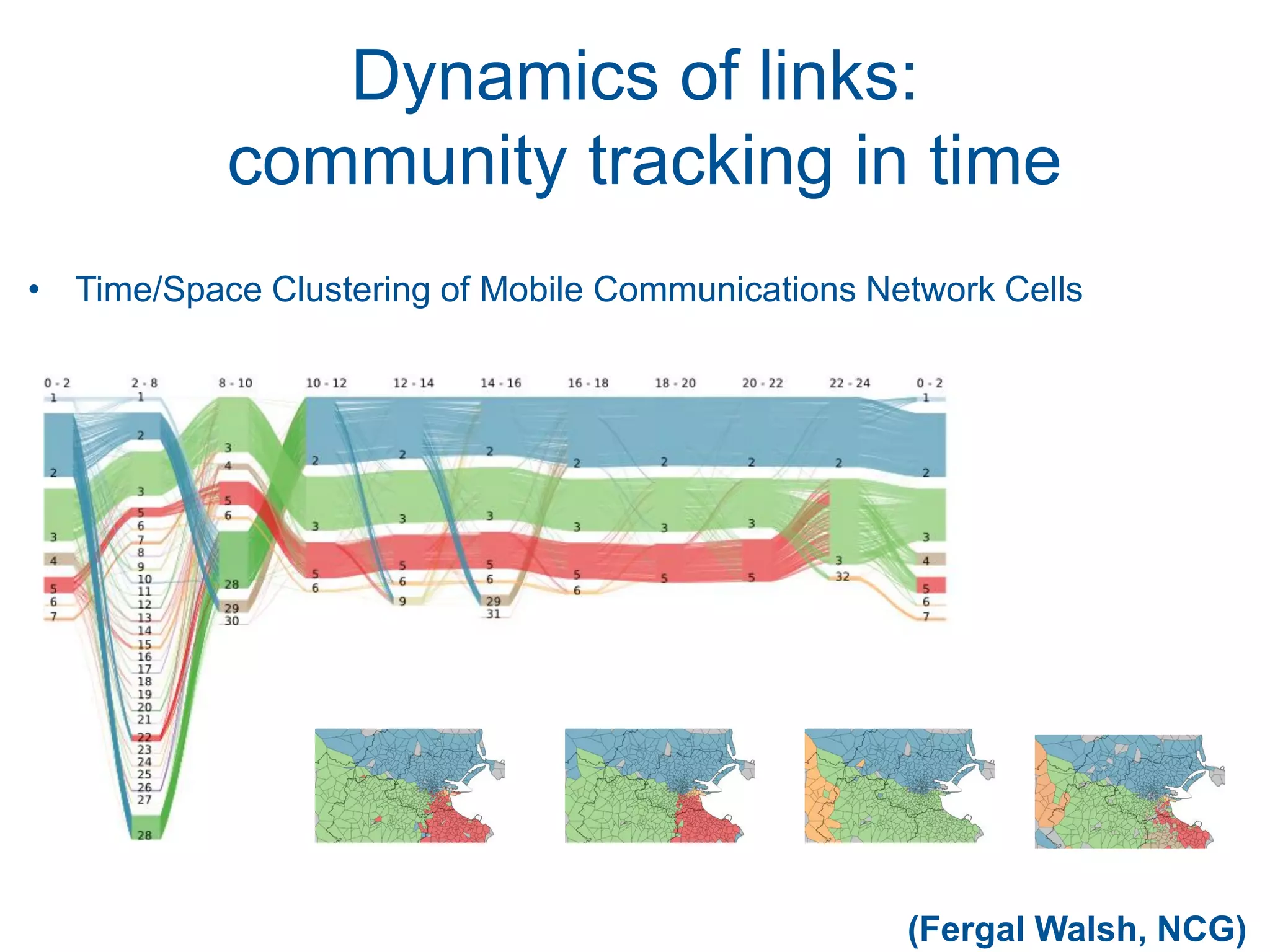
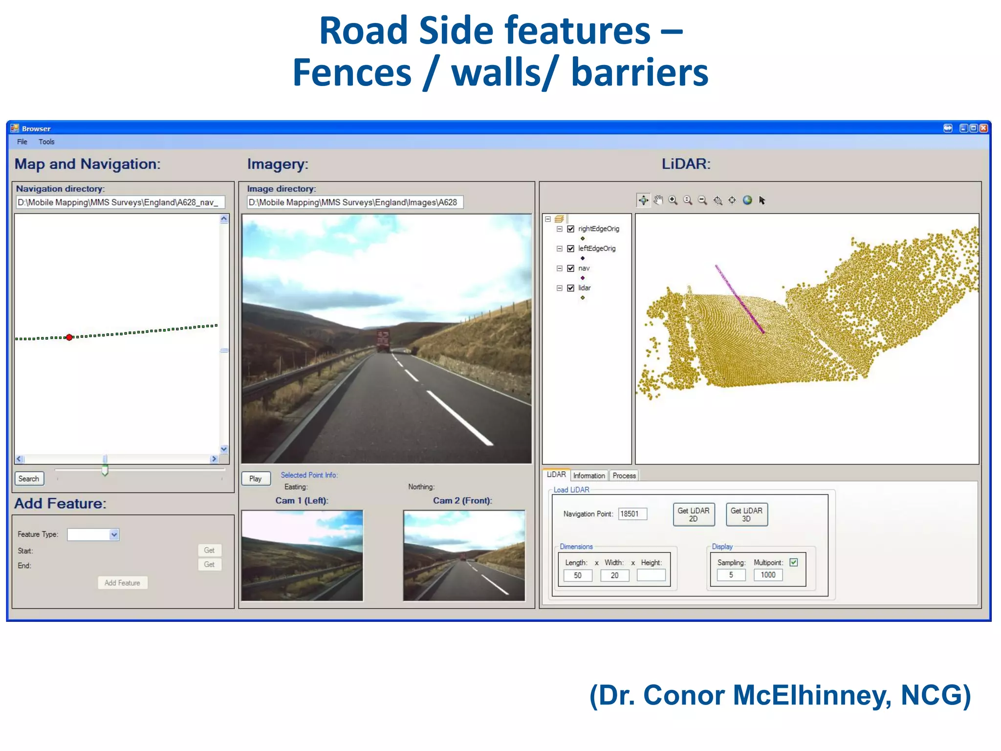
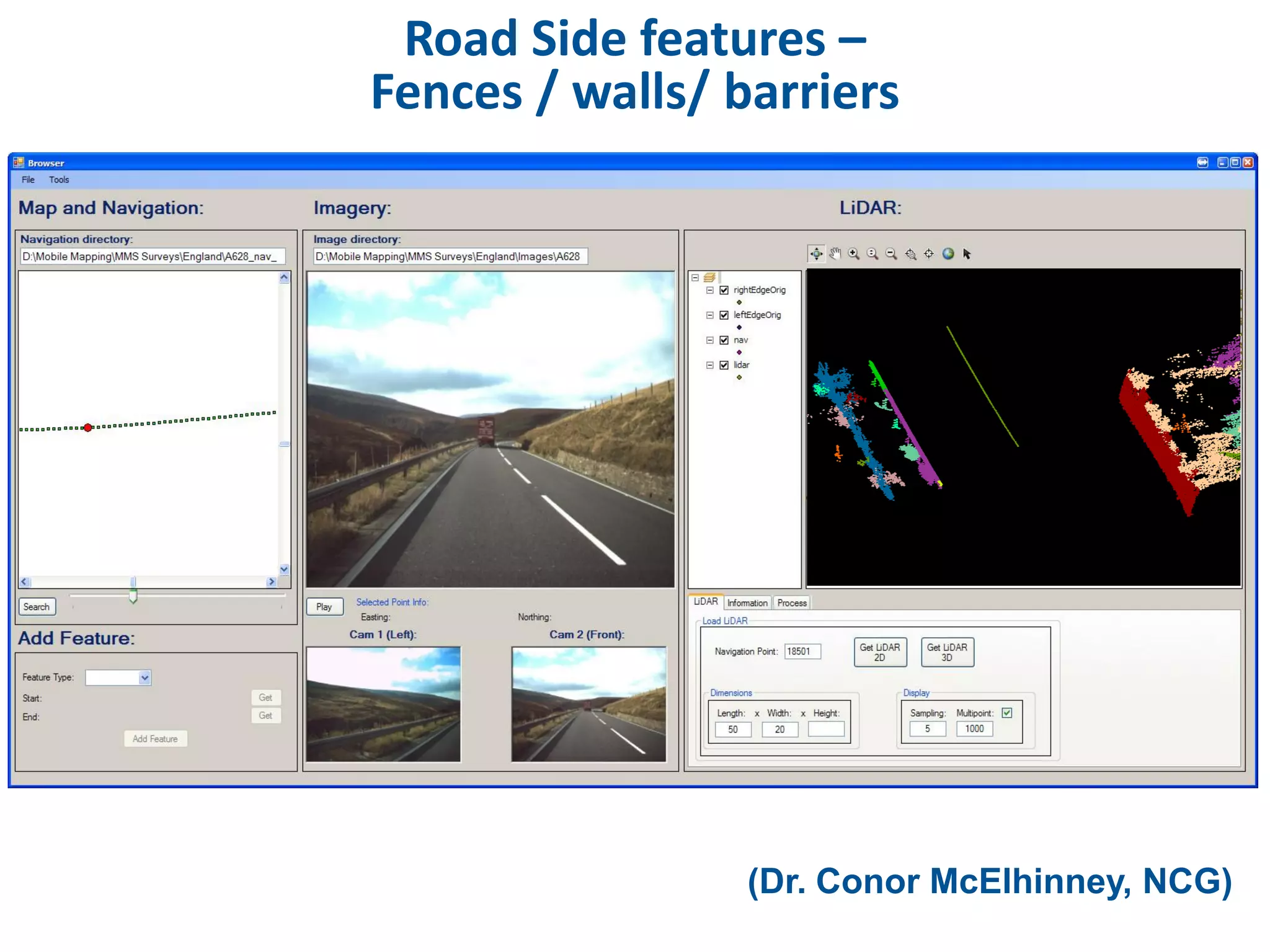
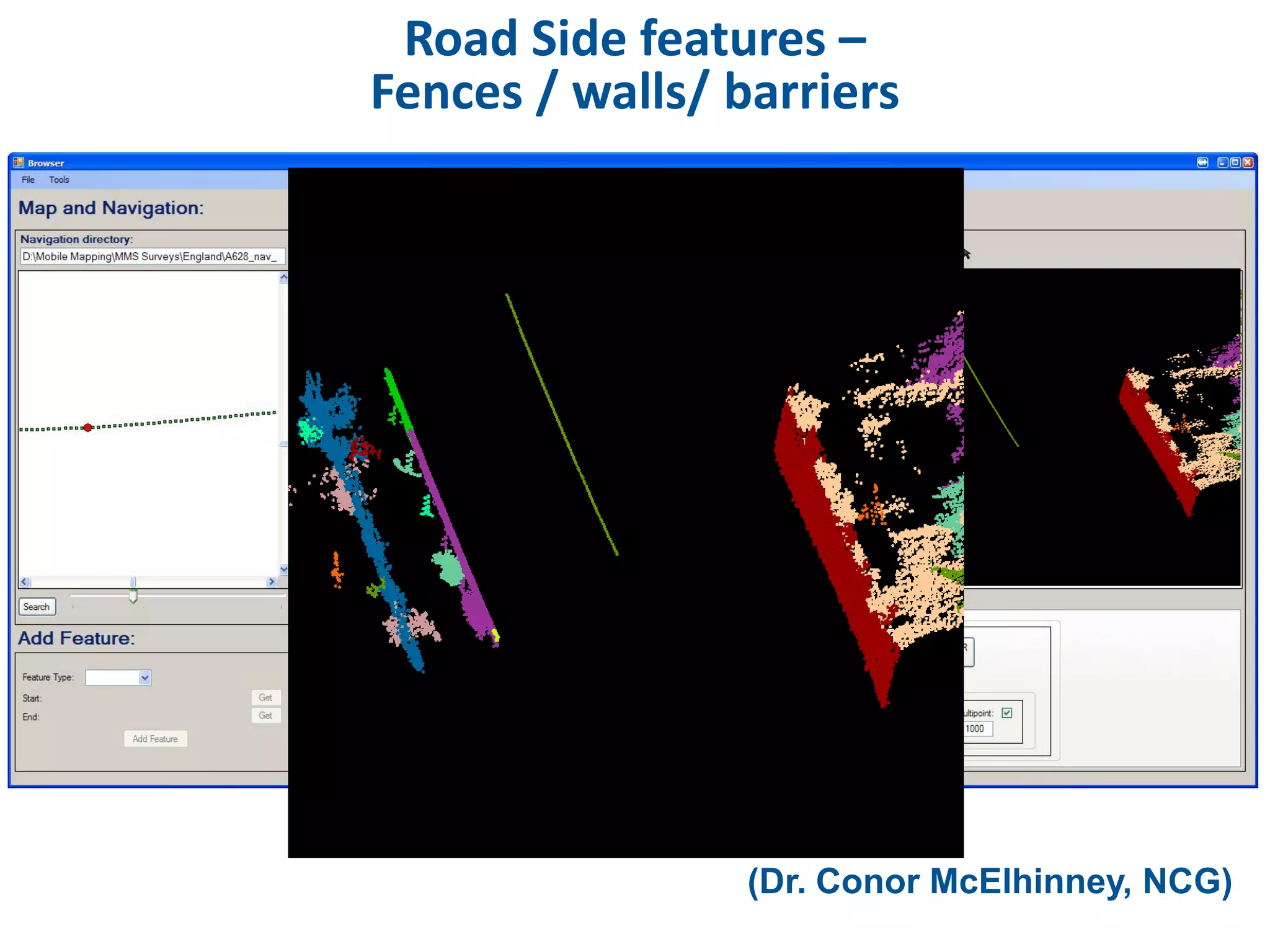
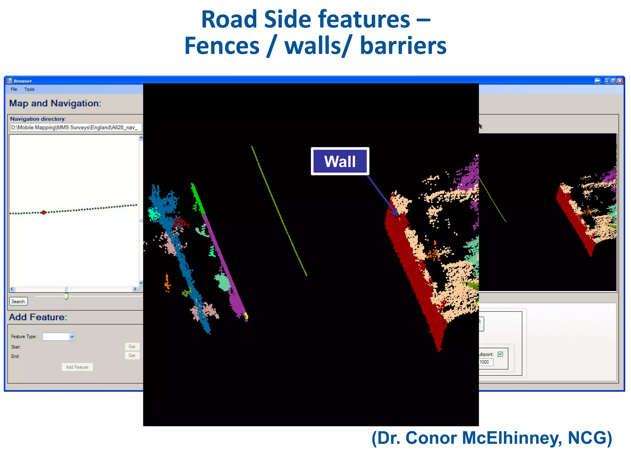
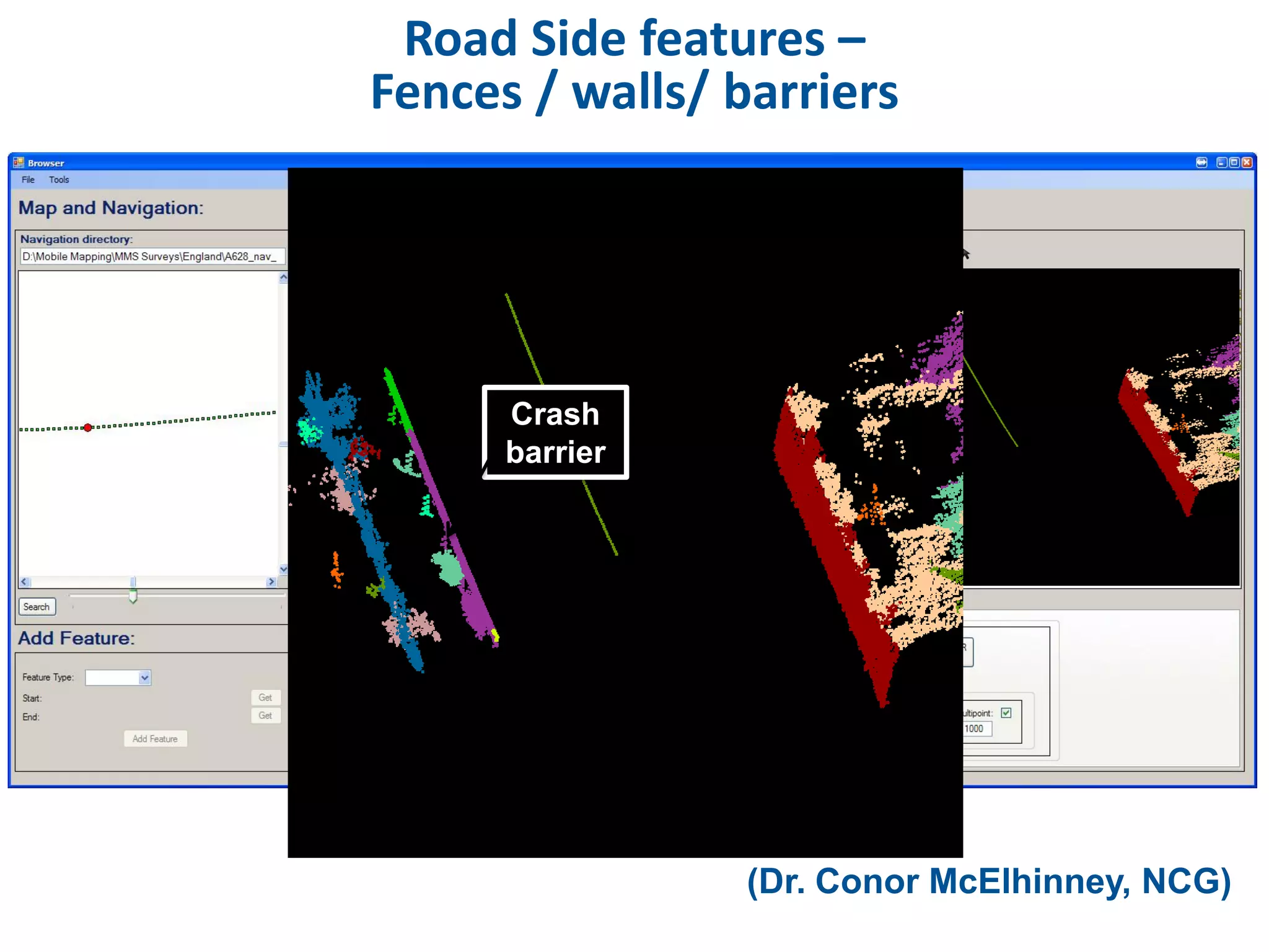
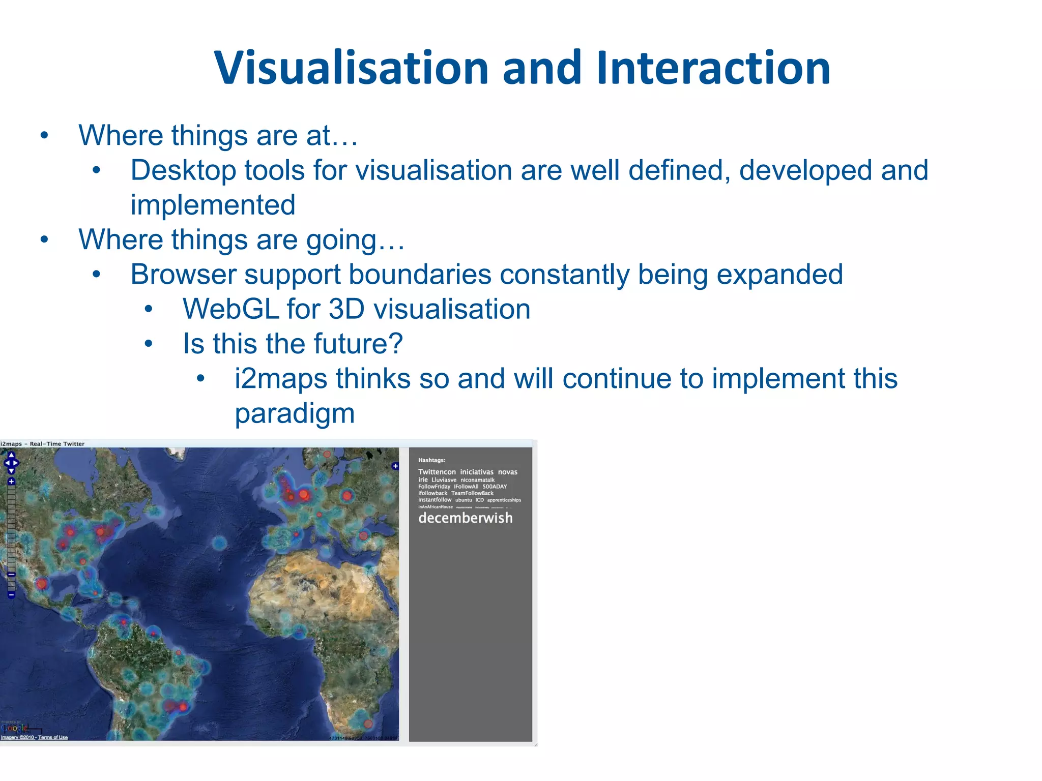
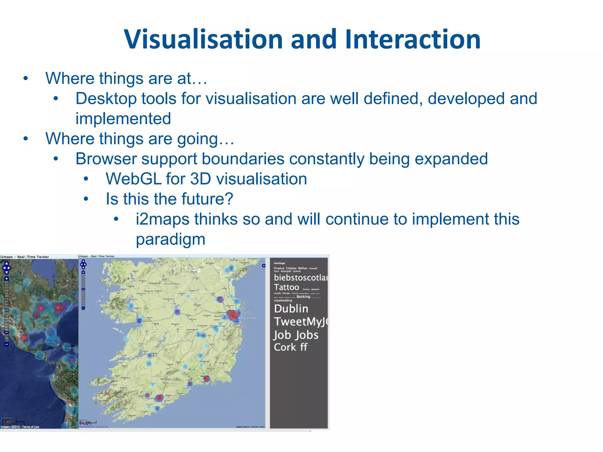
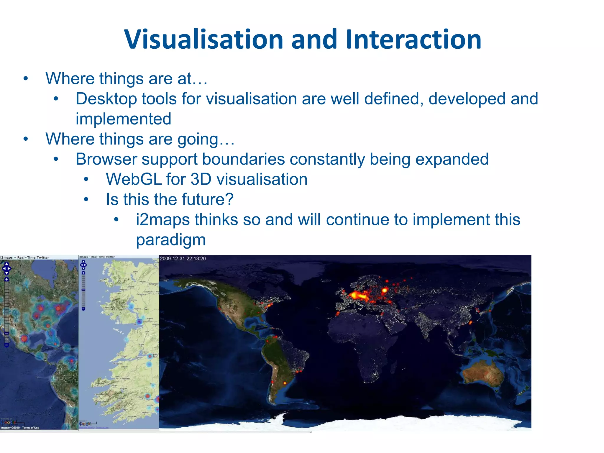
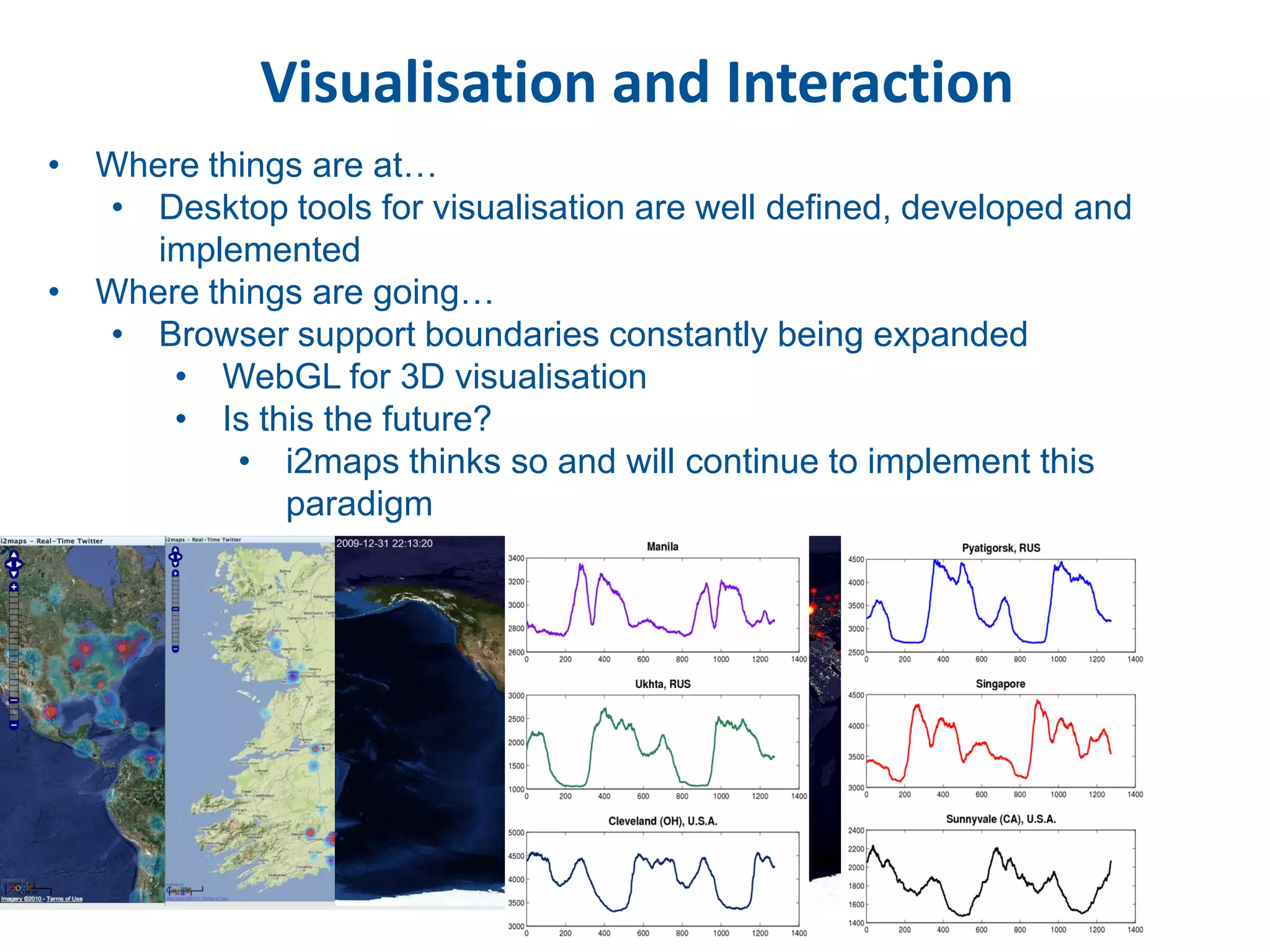
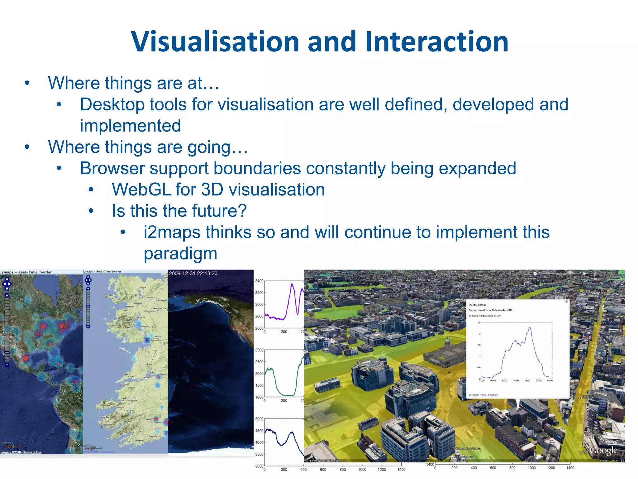
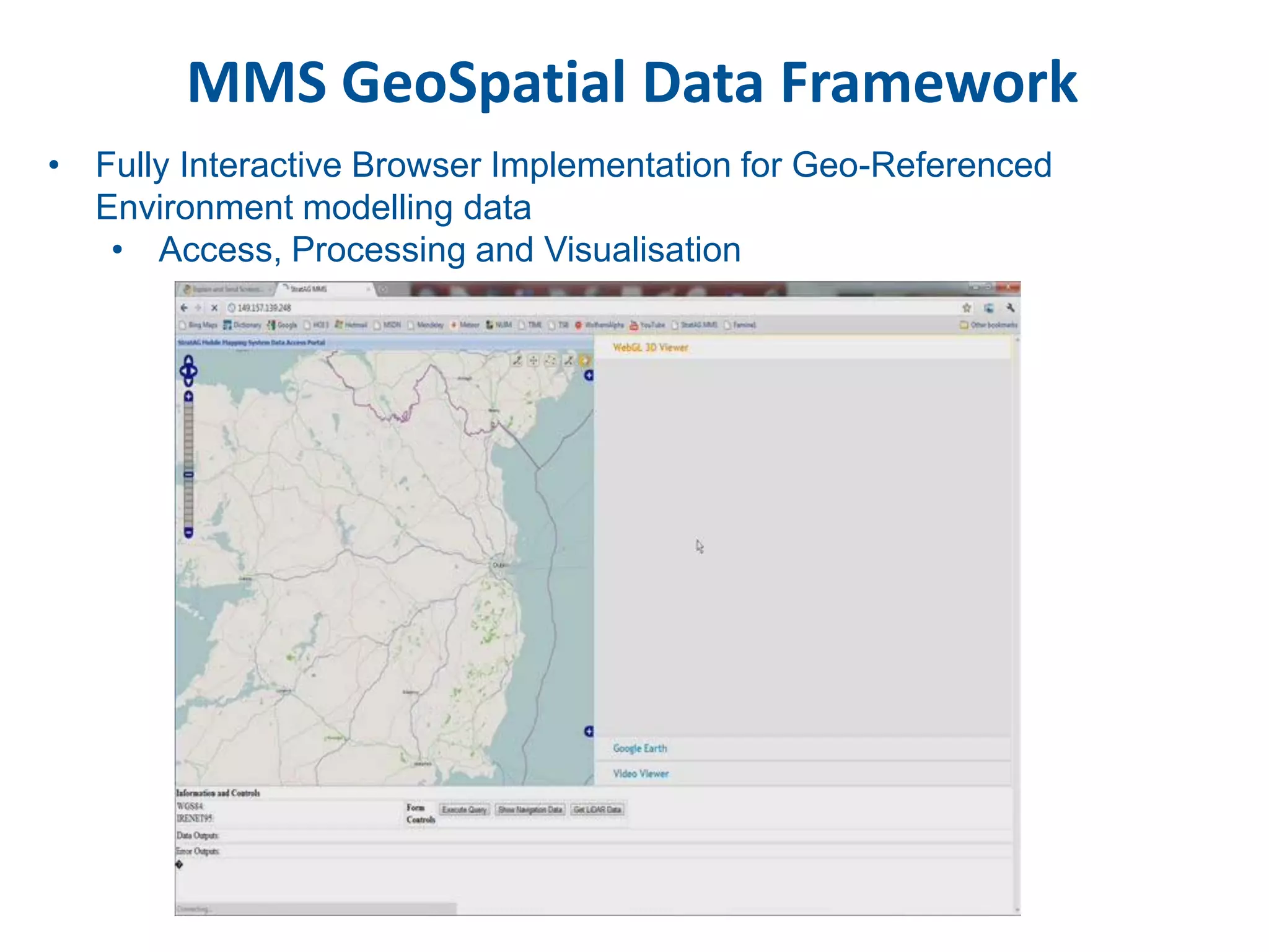
SlideShare a Scribd company logo
Geo-Referenced Human-Activity-Data;
 Access, Processing and Knowledge
             Extraction
              Paul Lewis
              (paul.lewis@nuim.ie)

              Dr. Conor McElhinney,
             Dr. Alexei Pozdnoukhov,
               Dr. Christian Kaiser,
                   Fergal Walsh


             Tuesday 31st May 2011
              University of Bremen
Outline
• Geospatial Data Accessibility
   • Modelling Challenges
   • Spatial Hierarchy Model
   • Access Process Examples

• Processing Paradigms and Knowledge Extraction
   • Knowledge Extraction Decision Processes
   • Spatial Workflow Patterns
   • Temporal Dynamics in Communities
   • Taking on the Tweets
   • Feature extraction informs Risk Assessment Knowledge

• Data and Knowledge Visualisation
   • Web Integration
   • Urban Model Data Extraction
   • Web geospatial knowledge extraction visualisation

• Wrap-Up
Data Geospatial-Accessibility
• Methodologies employed to enable and access the data’s geospatial
  content – generate the geography then access the geography

1. Raw Data Access - Function of Data Source Complexity
   • LiDAR/Imagery - 2D or 3D


   • Web-Content     Air Quality Sensor   Weather Measurements   VGI Feed (e.g. Twitter)   Surveillance Camera


     • Push              SMS              Web Page                   XML                       Video
     • Polling
     • Streaming                 Push                Polling                 Stream                    Stream

                                                 Data
                        Data Receiver                              Stream Handler            Stream Handler
                                                Crawler


2. Creating the Geospatial Content
   • MMS – GeoSpatial content is Inherent at very high resolution
   • Geocrowd - Semantics need to be well understood in non explicit
      context, twitter location(?)
Accessing through Spatial Hierarchy Models
• Spatial Hierarchy Modelling
   • MMS context uses a spatial extent modelling approach
   • Geocrowd will define this process on a content type access model

                              Constrained Workflow
                                         LiDAR folder


     Survey 10 Apr                   Survey 5 Dec                             Survey 2 May

Block 1                         Block 1                                  Block 1
Block 2                         Block 2                                  Block 2
                                                              .......
Block 3                         Block 3                                  Block 3
    .                               .                                        .
    .
Block N                             .
                                Block N                                      .
                                                                         Block N
    .                               .                                        .
MetaData: Geo Bounds, date,     MetaData: Geo Bounds, date,             MetaData: Geo Bounds, date,
processing done                 processing done                         processing done
Accessing through Spatial Hierarchy Models
• Optimising Data Accessibility in a circular data generation model
   • Intelligent Query Access now enabled for
      • Temporal
      • Spatial
      • Attributes
      • etc……
                                      Acquire


         Query                                                    Store


                       Data Model               Spatially
                      Visualisation              Model
Predictive Geospatial Data Access Modelling
• i2maps (Dr. Alexei Pozdnoukhov, NCG)
   • Real Time Weather Prediction
Geospatial Data Processing
• Knowledge Extraction informs Decision Support Processes
• What does this mean in a processing context?
   • A paradigm that is??
      • Centralised - Distributed
          • Spatial, Temporal…….


   • MMS Context is Constrained to static data Survey Processing
      • Temporal at best and partially, but (un)intentionally, Spatial.
      • Not collected independent of decision expectations

• High Level Decisions
   • Alternative model approaches
       • Geocrowd (Dictionary of Models)
Geospatial Data Processing
• Where we could go with this at a physical level
  • CLOUD
     • Distributed processing, parallelism, scalability, flexibility

• Parallelism
   • SDBMS access takes 1 sec.
   • But processing takes 60 sec.

                     • Scalability
                        • Processing scales to data model
                          updating – Weather, Twitter
                        • Storage scales model to data acquisition
                          – Lidar/Imagery
• This enables a Spatially-lead Workflow model at a knowledge level
   • Allows for fast information extraction
   • Allows for future knowledge extraction
Flows of calls form communities


North-South divide: typical destinations of calls from cells “   “
Dynamics of links: communities


                    (Fergal Walsh, NCG)
Dynamics of links:
           community tracking in time
• Time/Space Clustering of Mobile Communications Network Cells


                                                   (Fergal Walsh, NCG)
First steps: Twitter at NCG
Preliminary work on the content-rich data streams:
   • Real-time Twitter feed is monitored
   • Geo-referencing is done by tweet, user, or location
   • Activity levels processed and visualised with heat maps
   • Tags and messages are saved

Natural language processing:
some experience in NER task with NLTK, SENNA packages


 More work needed to get messages semantics and relate
                  topics to activities.
First steps: Twitter at NCG


                  (Dr. Christian Kaiser, NCG)
Road Side features –
Fences / walls/ barriers


                 (Dr. Conor McElhinney, NCG)
Road Side features –
Fences / walls/ barriers


                 (Dr. Conor McElhinney, NCG)
Road Side features –
Fences / walls/ barriers


                 (Dr. Conor McElhinney, NCG)
Road Side features –
Fences / walls/ barriers


            Wall


                   (Dr. Conor McElhinney, NCG)
Road Side features –
Fences / walls/ barriers


      Crash
      barrier


                 (Dr. Conor McElhinney, NCG)
Road Side features –
Fences / walls/ barriers


     Fence
Visualisation and Interaction
• Where things are at…
  • Desktop tools for visualisation are well defined, developed and
     implemented
• Where things are going…
  • Browser support boundaries constantly being expanded
      • WebGL for 3D visualisation
      • Is this the future?
          • i2maps thinks so and will continue to implement this
             paradigm
MMS GeoSpatial Data Framework
• Fully Interactive Browser Implementation for Geo-Referenced
  Environment modelling data
   • Access, Processing and Visualisation
To Wrap-Up
• MMS Work completed in 1.5 years
   • With 1.5 people years

• i2maps is a long-term open source project.
  Next releases: July 31st, for OSGeo LiveDVD and a FOSS4G
  workshop at Denver, on September 13th.

                     Going Forward


Research problems we’d like to solve within Geocrowd at NCG:

   1) Relate activity levels to content-rich data sources to enhance
      interpretability

   2) Make it computationally efficient and scalable (Internet-scale)

More Related Content

Similar to Geo-referenced human-activity-data; access, processing and knowledge extraction

Statistical Analysis of Web of Data Usage
Statistical Analysis of Web of Data UsageStatistical Analysis of Web of Data Usage
Statistical Analysis of Web of Data Usage
Markus Luczak-Rösch
 
About Scanning and Metadata Standards - NEMO 2010
About Scanning and Metadata Standards - NEMO 2010About Scanning and Metadata Standards - NEMO 2010
Situation driven development: a methodology for the development of context-aw...
Situation driven development: a methodology for the development of context-aw...Situation driven development: a methodology for the development of context-aw...
Situation driven development: a methodology for the development of context-aw...
damarcant
 
Advancements In Visualization Of Remotely Sensed 3D Data
Advancements In Visualization Of Remotely Sensed 3D DataAdvancements In Visualization Of Remotely Sensed 3D Data
Advancements In Visualization Of Remotely Sensed 3D Data
Merrick & Company
 
HiPEAC 2019 Workshop - Real-Time Modelling Visual Scenes with Biological Insp...
HiPEAC 2019 Workshop - Real-Time Modelling Visual Scenes with Biological Insp...HiPEAC 2019 Workshop - Real-Time Modelling Visual Scenes with Biological Insp...
HiPEAC 2019 Workshop - Real-Time Modelling Visual Scenes with Biological Insp...
Tulipp. Eu
 
Geospatial Rectification of Web Transactions and Data Security
Geospatial Rectification of Web Transactions and Data SecurityGeospatial Rectification of Web Transactions and Data Security
Geospatial Rectification of Web Transactions and Data Security
Phoenix TS
 
Large Scale Data Mining using Genetics-Based Machine Learning
Large Scale Data Mining using Genetics-Based Machine LearningLarge Scale Data Mining using Genetics-Based Machine Learning
Large Scale Data Mining using Genetics-Based Machine Learning
jaumebp
 
3D Objects in Wat Makutkasattriyaram's e-Museum: Progress, Experiences, and A...
3D Objects in Wat Makutkasattriyaram's e-Museum: Progress, Experiences, and A...3D Objects in Wat Makutkasattriyaram's e-Museum: Progress, Experiences, and A...
3D Objects in Wat Makutkasattriyaram's e-Museum: Progress, Experiences, and A...
Rachabodin Suwannakanthi
 
How DITA Got Her Groove Back: Going Mapless with Don Day
How DITA Got Her Groove Back: Going Mapless with Don DayHow DITA Got Her Groove Back: Going Mapless with Don Day
How DITA Got Her Groove Back: Going Mapless with Don Day
Information Development World
 
สร้างสรรค์กิจกรรมการเรียนรู้ที่มีความหมาย ด้วยสื่อ Learning Object
สร้างสรรค์กิจกรรมการเรียนรู้ที่มีความหมาย ด้วยสื่อ Learning Object สร้างสรรค์กิจกรรมการเรียนรู้ที่มีความหมาย ด้วยสื่อ Learning Object
สร้างสรรค์กิจกรรมการเรียนรู้ที่มีความหมาย ด้วยสื่อ Learning Object
AngAng_ETC
 
CSC 8101 Non Relational Databases
CSC 8101 Non Relational DatabasesCSC 8101 Non Relational Databases
CSC 8101 Non Relational Databases
sjwoodman
 
Large Scale Data Mining using Genetics-Based Machine Learning
Large Scale Data Mining using   Genetics-Based Machine LearningLarge Scale Data Mining using   Genetics-Based Machine Learning
Large Scale Data Mining using Genetics-Based Machine Learning
Xavier Llorà
 
Hawaii Pacific GIS Conference 2012: LiDAR for Intrastructure and Terrian Mapp...
Hawaii Pacific GIS Conference 2012: LiDAR for Intrastructure and Terrian Mapp...Hawaii Pacific GIS Conference 2012: LiDAR for Intrastructure and Terrian Mapp...
Hawaii Pacific GIS Conference 2012: LiDAR for Intrastructure and Terrian Mapp...
Hawaii Geographic Information Coordinating Council
 
ICS1020CV_2022.pdf
ICS1020CV_2022.pdfICS1020CV_2022.pdf
ICS1020CV_2022.pdf
Vanessa Camilleri
 
Big Data Analysis : Deciphering the haystack
Big Data Analysis : Deciphering the haystack Big Data Analysis : Deciphering the haystack
Big Data Analysis : Deciphering the haystack
Srinath Perera
 
Combining Data Mining and Machine Learning for Effective User Profiling
Combining Data Mining and Machine Learning for Effective User ProfilingCombining Data Mining and Machine Learning for Effective User Profiling
Combining Data Mining and Machine Learning for Effective User Profiling
CodePolitan
 
Tour of Big Data
Tour of Big DataTour of Big Data
Tour of Big Data
Raymond Yu
 
Bertenthal
BertenthalBertenthal
Bertenthal
Jesse Lingeman
 
Project Matsu
Project MatsuProject Matsu
Project Matsu
Collin Bennett
 
Large scale computing
Large scale computing Large scale computing
Large scale computing
Bhupesh Bansal
 

Similar to Geo-referenced human-activity-data; access, processing and knowledge extraction (20)

Statistical Analysis of Web of Data Usage
Statistical Analysis of Web of Data UsageStatistical Analysis of Web of Data Usage
Statistical Analysis of Web of Data Usage
 
About Scanning and Metadata Standards - NEMO 2010
About Scanning and Metadata Standards - NEMO 2010About Scanning and Metadata Standards - NEMO 2010
About Scanning and Metadata Standards - NEMO 2010
 
Situation driven development: a methodology for the development of context-aw...
Situation driven development: a methodology for the development of context-aw...Situation driven development: a methodology for the development of context-aw...
Situation driven development: a methodology for the development of context-aw...
 
Advancements In Visualization Of Remotely Sensed 3D Data
Advancements In Visualization Of Remotely Sensed 3D DataAdvancements In Visualization Of Remotely Sensed 3D Data
Advancements In Visualization Of Remotely Sensed 3D Data
 
HiPEAC 2019 Workshop - Real-Time Modelling Visual Scenes with Biological Insp...
HiPEAC 2019 Workshop - Real-Time Modelling Visual Scenes with Biological Insp...HiPEAC 2019 Workshop - Real-Time Modelling Visual Scenes with Biological Insp...
HiPEAC 2019 Workshop - Real-Time Modelling Visual Scenes with Biological Insp...
 
Geospatial Rectification of Web Transactions and Data Security
Geospatial Rectification of Web Transactions and Data SecurityGeospatial Rectification of Web Transactions and Data Security
Geospatial Rectification of Web Transactions and Data Security
 
Large Scale Data Mining using Genetics-Based Machine Learning
Large Scale Data Mining using Genetics-Based Machine LearningLarge Scale Data Mining using Genetics-Based Machine Learning
Large Scale Data Mining using Genetics-Based Machine Learning
 
3D Objects in Wat Makutkasattriyaram's e-Museum: Progress, Experiences, and A...
3D Objects in Wat Makutkasattriyaram's e-Museum: Progress, Experiences, and A...3D Objects in Wat Makutkasattriyaram's e-Museum: Progress, Experiences, and A...
3D Objects in Wat Makutkasattriyaram's e-Museum: Progress, Experiences, and A...
 
How DITA Got Her Groove Back: Going Mapless with Don Day
How DITA Got Her Groove Back: Going Mapless with Don DayHow DITA Got Her Groove Back: Going Mapless with Don Day
How DITA Got Her Groove Back: Going Mapless with Don Day
 
สร้างสรรค์กิจกรรมการเรียนรู้ที่มีความหมาย ด้วยสื่อ Learning Object
สร้างสรรค์กิจกรรมการเรียนรู้ที่มีความหมาย ด้วยสื่อ Learning Object สร้างสรรค์กิจกรรมการเรียนรู้ที่มีความหมาย ด้วยสื่อ Learning Object
สร้างสรรค์กิจกรรมการเรียนรู้ที่มีความหมาย ด้วยสื่อ Learning Object
 
CSC 8101 Non Relational Databases
CSC 8101 Non Relational DatabasesCSC 8101 Non Relational Databases
CSC 8101 Non Relational Databases
 
Large Scale Data Mining using Genetics-Based Machine Learning
Large Scale Data Mining using   Genetics-Based Machine LearningLarge Scale Data Mining using   Genetics-Based Machine Learning
Large Scale Data Mining using Genetics-Based Machine Learning
 
Hawaii Pacific GIS Conference 2012: LiDAR for Intrastructure and Terrian Mapp...
Hawaii Pacific GIS Conference 2012: LiDAR for Intrastructure and Terrian Mapp...Hawaii Pacific GIS Conference 2012: LiDAR for Intrastructure and Terrian Mapp...
Hawaii Pacific GIS Conference 2012: LiDAR for Intrastructure and Terrian Mapp...
 
ICS1020CV_2022.pdf
ICS1020CV_2022.pdfICS1020CV_2022.pdf
ICS1020CV_2022.pdf
 
Big Data Analysis : Deciphering the haystack
Big Data Analysis : Deciphering the haystack Big Data Analysis : Deciphering the haystack
Big Data Analysis : Deciphering the haystack
 
Combining Data Mining and Machine Learning for Effective User Profiling
Combining Data Mining and Machine Learning for Effective User ProfilingCombining Data Mining and Machine Learning for Effective User Profiling
Combining Data Mining and Machine Learning for Effective User Profiling
 
Tour of Big Data
Tour of Big DataTour of Big Data
Tour of Big Data
 
Bertenthal
BertenthalBertenthal
Bertenthal
 
Project Matsu
Project MatsuProject Matsu
Project Matsu
 
Large scale computing
Large scale computing Large scale computing
Large scale computing
 

Geo-referenced human-activity-data; access, processing and knowledge extraction

  • 1. Geo-Referenced Human-Activity-Data; Access, Processing and Knowledge Extraction Paul Lewis (paul.lewis@nuim.ie) Dr. Conor McElhinney, Dr. Alexei Pozdnoukhov, Dr. Christian Kaiser, Fergal Walsh Tuesday 31st May 2011 University of Bremen
  • 2. Outline • Geospatial Data Accessibility • Modelling Challenges • Spatial Hierarchy Model • Access Process Examples • Processing Paradigms and Knowledge Extraction • Knowledge Extraction Decision Processes • Spatial Workflow Patterns • Temporal Dynamics in Communities • Taking on the Tweets • Feature extraction informs Risk Assessment Knowledge • Data and Knowledge Visualisation • Web Integration • Urban Model Data Extraction • Web geospatial knowledge extraction visualisation • Wrap-Up
  • 3. Data Geospatial-Accessibility • Methodologies employed to enable and access the data’s geospatial content – generate the geography then access the geography 1. Raw Data Access - Function of Data Source Complexity • LiDAR/Imagery - 2D or 3D • Web-Content Air Quality Sensor Weather Measurements VGI Feed (e.g. Twitter) Surveillance Camera • Push SMS Web Page XML Video • Polling • Streaming Push Polling Stream Stream Data Data Receiver Stream Handler Stream Handler Crawler 2. Creating the Geospatial Content • MMS – GeoSpatial content is Inherent at very high resolution • Geocrowd - Semantics need to be well understood in non explicit context, twitter location(?)
  • 4. Accessing through Spatial Hierarchy Models • Spatial Hierarchy Modelling • MMS context uses a spatial extent modelling approach • Geocrowd will define this process on a content type access model Constrained Workflow LiDAR folder Survey 10 Apr Survey 5 Dec Survey 2 May Block 1 Block 1 Block 1 Block 2 Block 2 Block 2 ....... Block 3 Block 3 Block 3 . . . . Block N . Block N . Block N . . . MetaData: Geo Bounds, date, MetaData: Geo Bounds, date, MetaData: Geo Bounds, date, processing done processing done processing done
  • 5. Accessing through Spatial Hierarchy Models • Optimising Data Accessibility in a circular data generation model • Intelligent Query Access now enabled for • Temporal • Spatial • Attributes • etc…… Acquire Query Store Data Model Spatially Visualisation Model
  • 6. Accessing through Spatial Hierarchy Models • Optimising Data Accessibility in a circular data generation model • Intelligent Query Access now enabled for • Temporal • Spatial • Attributes • etc…… Acquire Query Store Data Model Spatially Visualisation Model
  • 7. Accessing through Spatial Hierarchy Models • Optimising Data Accessibility in a circular data generation model • Intelligent Query Access now enabled for • Temporal • Spatial • Attributes • etc…… Acquire Query Store Data Model Spatially Visualisation Model
  • 8. Accessing through Spatial Hierarchy Models • Optimising Data Accessibility in a circular data generation model • Intelligent Query Access now enabled for • Temporal • Spatial • Attributes • etc…… Acquire Query Store Data Model Spatially Visualisation Model
  • 9. Predictive Geospatial Data Access Modelling • i2maps (Dr. Alexei Pozdnoukhov, NCG) • Real Time Weather Prediction
  • 10. Geospatial Data Processing • Knowledge Extraction informs Decision Support Processes • What does this mean in a processing context? • A paradigm that is?? • Centralised - Distributed • Spatial, Temporal……. • MMS Context is Constrained to static data Survey Processing • Temporal at best and partially, but (un)intentionally, Spatial. • Not collected independent of decision expectations • High Level Decisions • Alternative model approaches • Geocrowd (Dictionary of Models)
  • 11. Geospatial Data Processing • Where we could go with this at a physical level • CLOUD • Distributed processing, parallelism, scalability, flexibility • Parallelism • SDBMS access takes 1 sec. • But processing takes 60 sec. • Scalability • Processing scales to data model updating – Weather, Twitter • Storage scales model to data acquisition – Lidar/Imagery • This enables a Spatially-lead Workflow model at a knowledge level • Allows for fast information extraction • Allows for future knowledge extraction
  • 12. Flows of calls form communities North-South divide: typical destinations of calls from cells “ “
  • 13. Dynamics of links: communities (Fergal Walsh, NCG)
  • 14. Dynamics of links: community tracking in time • Time/Space Clustering of Mobile Communications Network Cells (Fergal Walsh, NCG)
  • 15. First steps: Twitter at NCG Preliminary work on the content-rich data streams: • Real-time Twitter feed is monitored • Geo-referencing is done by tweet, user, or location • Activity levels processed and visualised with heat maps • Tags and messages are saved Natural language processing: some experience in NER task with NLTK, SENNA packages More work needed to get messages semantics and relate topics to activities.
  • 16. First steps: Twitter at NCG (Dr. Christian Kaiser, NCG)
  • 17. Road Side features – Fences / walls/ barriers (Dr. Conor McElhinney, NCG)
  • 18. Road Side features – Fences / walls/ barriers (Dr. Conor McElhinney, NCG)
  • 19. Road Side features – Fences / walls/ barriers (Dr. Conor McElhinney, NCG)
  • 20. Road Side features – Fences / walls/ barriers Wall (Dr. Conor McElhinney, NCG)
  • 21. Road Side features – Fences / walls/ barriers Crash barrier (Dr. Conor McElhinney, NCG)
  • 22. Road Side features – Fences / walls/ barriers Fence
  • 23. Visualisation and Interaction • Where things are at… • Desktop tools for visualisation are well defined, developed and implemented • Where things are going… • Browser support boundaries constantly being expanded • WebGL for 3D visualisation • Is this the future? • i2maps thinks so and will continue to implement this paradigm
  • 24. Visualisation and Interaction • Where things are at… • Desktop tools for visualisation are well defined, developed and implemented • Where things are going… • Browser support boundaries constantly being expanded • WebGL for 3D visualisation • Is this the future? • i2maps thinks so and will continue to implement this paradigm
  • 25. Visualisation and Interaction • Where things are at… • Desktop tools for visualisation are well defined, developed and implemented • Where things are going… • Browser support boundaries constantly being expanded • WebGL for 3D visualisation • Is this the future? • i2maps thinks so and will continue to implement this paradigm
  • 26. Visualisation and Interaction • Where things are at… • Desktop tools for visualisation are well defined, developed and implemented • Where things are going… • Browser support boundaries constantly being expanded • WebGL for 3D visualisation • Is this the future? • i2maps thinks so and will continue to implement this paradigm
  • 27. Visualisation and Interaction • Where things are at… • Desktop tools for visualisation are well defined, developed and implemented • Where things are going… • Browser support boundaries constantly being expanded • WebGL for 3D visualisation • Is this the future? • i2maps thinks so and will continue to implement this paradigm
  • 28. Visualisation and Interaction • Where things are at… • Desktop tools for visualisation are well defined, developed and implemented • Where things are going… • Browser support boundaries constantly being expanded • WebGL for 3D visualisation • Is this the future? • i2maps thinks so and will continue to implement this paradigm
  • 29. Visualisation and Interaction • Where things are at… • Desktop tools for visualisation are well defined, developed and implemented • Where things are going… • Browser support boundaries constantly being expanded • WebGL for 3D visualisation • Is this the future? • i2maps thinks so and will continue to implement this paradigm
  • 30. MMS GeoSpatial Data Framework • Fully Interactive Browser Implementation for Geo-Referenced Environment modelling data • Access, Processing and Visualisation
  • 31. To Wrap-Up • MMS Work completed in 1.5 years • With 1.5 people years • i2maps is a long-term open source project. Next releases: July 31st, for OSGeo LiveDVD and a FOSS4G workshop at Denver, on September 13th. Going Forward Research problems we’d like to solve within Geocrowd at NCG: 1) Relate activity levels to content-rich data sources to enhance interpretability 2) Make it computationally efficient and scalable (Internet-scale)