SlideShare a Scribd company logo
1 of 18
Download to read offline
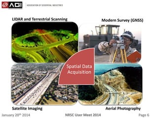
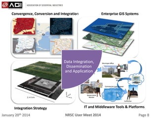
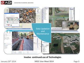
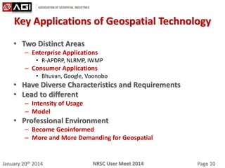
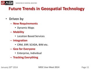
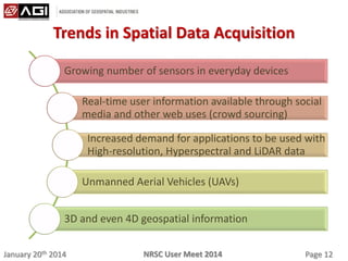
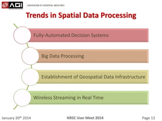
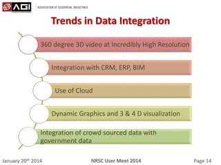
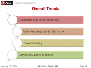
January 20th 2014 Page 1NRSC User Meet 2014
AGI PERSPECTIVE ON FUTURE TRENDS IN
GEOSPATIAL TECHNOLOGIES
Dr. Yogita Shukla
Fellow, AGI
January 20th 2014 Page 2NRSC User Meet 2014
Agenda
• Geospatial Technologies
• Association of Geospatial Industries and Its Role
• Geospatial Workflow
• Key Applications of Geospatial Technology
• Future Trends in Geospatial Technology
• About AGI
January 20th 2014 Page 3NRSC User Meet 2014
Geospatial Technologies
• Include wide ranging technologies
– Spatial Data Acquisition
• Surveying and GNSS
• Remote Sensing
– Spatial Data Processing
• Digital Image Processing
• Photogrammetry
• GIS
– Integration of Spatial and Non-spatial Data
• GIS
January 20th 2014 Page 4NRSC User Meet 2014
Association of Geospatial Industries and Its Role
• Premier body of Geospatial Industries in India
• Promote the usage of Geospatial Technologies across sectors
• Advise and Collaborate with Policy Formulators and
Geospatial Decision Makers for “Right” Geospatial
Technology Adoption
• Build a Vibrant Geospatial Community
• Create Forums to bring together all stakeholders for effective
Geospatial usage
• Research and inform through Whitepapers, Newsletters and
Workshops
• Work towards making Geospatial ubiquitous and integral for
effective management
January 20th 2014 Page 5NRSC User Meet 2014
Geospatial Workflow
Spatial Data
Acquisition
Spatial Data
Processing
Data
Integration,
Dissemination
and
Application
Data Updation
and
Maintenance
January 20th 2014 Page 6NRSC User Meet 2014
Spatial Data
Acquisition
LIDAR and Terrestrial Scanning Modern Survey (GNSS)
Satellite Imaging Aerial Photography
January 20th 2014 Page 7NRSC User Meet 2014
Spatial Data
Processing
LIDAR ProcessingPhotogrammetry
Digital Image Processing Image Interpretation
January 20th 2014 Page 8NRSC User Meet 2014
Convergence, Conversion and Integration Enterprise GIS Systems
Integration Strategy IT and Middleware Tools & Platforms
Data Integration,
Dissemination
and Application
January 20th 2014 Page 9NRSC User Meet 2014
Involve continued use of Technologies
Data Updation
and
Maintenance
January 20th 2014 Page 10NRSC User Meet 2014
Key Applications of Geospatial Technology
• Two Distinct Areas
– Enterprise Applications
• R-APDRP, NLRMP, IWMP
– Consumer Applications
• Bhuvan, Google, Voonobo
• Have Diverse Characteristics and Requirements
• Lead to different
– Intensity of Usage
– Model
• Professional Environment
– Become Geoinformed
– More and More Demanding for Geospatial
January 20th 2014 Page 11NRSC User Meet 2014
Future Trends in Geospatial Technology
• Driven by
– New Requirements
• Dynamic Maps
– Mobility
• Location Based Services
– Integration
• CRM, ERP, SCADA, BIM etc.
– Geo for Everyone
• Enterprise, Individual
– Tracking Everything
January 20th 2014 Page 12NRSC User Meet 2014
Trends in Spatial Data Acquisition
Growing number of sensors in everyday devices
Real-time user information available through social
media and other web uses (crowd sourcing)
Increased demand for applications to be used with
High-resolution, Hyperspectral and LiDAR data
Unmanned Aerial Vehicles (UAVs)
3D and even 4D geospatial information
January 20th 2014 Page 13NRSC User Meet 2014
Trends in Spatial Data Processing
Fully-Automated Decision Systems
Big Data Processing
Establishment of Geospatial Data Infrastructure
Wireless Streaming in Real Time
January 20th 2014 Page 14NRSC User Meet 2014
Trends in Data Integration
360 degree 3D video at Incredibly High Resolution
Integration with CRM, ERP, BIM
Use of Cloud
Dynamic Graphics and 3 & 4 D visualization
Integration of crowd sourced data with
government data
January 20th 2014 Page 15NRSC User Meet 2014
Trends in Legal Aspects
Confusion and lack of clarity over data ownership,
distribution rights, liabilities and other aspects
Legislation will increasingly recognise digital
signatures as digital cadastre/deeds
National Geospatial data infrastructures as
statutory infrastructures
Public policy and law to move into a direction to
protect the interests and rights of people
January 20th 2014 Page 16NRSC User Meet 2014
Trends in Geospatial Education
Tailored Programmes
Spatial literacy will be centred more on
increasing spatial awareness
Multidisciplinary
January 20th 2014 Page 17NRSC User Meet 2014
Overall Trends
Geospatial Becoming Ubiquitous
Volunteer Geographic Information
Crowdsourcing
Community-based mapping
January 20th 2014 Page 18NRSC User Meet 2014
Thanks
Contact details:
• M: +91-9313345486
• e-mail: yogita.shukla@agiindia.com

More Related Content

What's hot

What to expect out of National Centre of Geo-Informatics (NCoG)
What to expect out of National Centre of Geo-Informatics (NCoG)What to expect out of National Centre of Geo-Informatics (NCoG)
What to expect out of National Centre of Geo-Informatics (NCoG)Geospatial Media & Communications
 
FIRA 2017 - SITIA - Fabien Arignon
FIRA 2017 - SITIA - Fabien ArignonFIRA 2017 - SITIA - Fabien Arignon
FIRA 2017 - SITIA - Fabien ArignonFIRA
 
Compass Informatics - Overview
Compass Informatics - OverviewCompass Informatics - Overview
Compass Informatics - Overviewgoriain
 
Role of information technology during disaster
Role of information technology during disasterRole of information technology during disaster
Role of information technology during disasterNirab Pudasaini
 
Mvrpcgis p&z 2016
Mvrpcgis p&z 2016Mvrpcgis p&z 2016
Mvrpcgis p&z 2016MVRPC
 
OpenStreetMap: Open-Local-GeographicalData
OpenStreetMap: Open-Local-GeographicalDataOpenStreetMap: Open-Local-GeographicalData
OpenStreetMap: Open-Local-GeographicalDataPatipat Keng Susumpow
 
dot.rural Slides November 2013 for DE2013
dot.rural Slides November 2013 for DE2013dot.rural Slides November 2013 for DE2013
dot.rural Slides November 2013 for DE2013dotrural
 
Roland Lenain et Jean-Michel Le Bars
Roland Lenain et Jean-Michel Le BarsRoland Lenain et Jean-Michel Le Bars
Roland Lenain et Jean-Michel Le BarsFIRA
 

What's hot (9)

What to expect out of National Centre of Geo-Informatics (NCoG)
What to expect out of National Centre of Geo-Informatics (NCoG)What to expect out of National Centre of Geo-Informatics (NCoG)
What to expect out of National Centre of Geo-Informatics (NCoG)
 
Online GIS platform for Agricultural Development in Ghana
Online GIS platform for Agricultural Development in GhanaOnline GIS platform for Agricultural Development in Ghana
Online GIS platform for Agricultural Development in Ghana
 
FIRA 2017 - SITIA - Fabien Arignon
FIRA 2017 - SITIA - Fabien ArignonFIRA 2017 - SITIA - Fabien Arignon
FIRA 2017 - SITIA - Fabien Arignon
 
Compass Informatics - Overview
Compass Informatics - OverviewCompass Informatics - Overview
Compass Informatics - Overview
 
Role of information technology during disaster
Role of information technology during disasterRole of information technology during disaster
Role of information technology during disaster
 
Mvrpcgis p&z 2016
Mvrpcgis p&z 2016Mvrpcgis p&z 2016
Mvrpcgis p&z 2016
 
OpenStreetMap: Open-Local-GeographicalData
OpenStreetMap: Open-Local-GeographicalDataOpenStreetMap: Open-Local-GeographicalData
OpenStreetMap: Open-Local-GeographicalData
 
dot.rural Slides November 2013 for DE2013
dot.rural Slides November 2013 for DE2013dot.rural Slides November 2013 for DE2013
dot.rural Slides November 2013 for DE2013
 
Roland Lenain et Jean-Michel Le Bars
Roland Lenain et Jean-Michel Le BarsRoland Lenain et Jean-Michel Le Bars
Roland Lenain et Jean-Michel Le Bars
 

Similar to AGI Presentation for NRSC USER MEET- final

ACT 2014 Empowering Travellers with Online Transport Information Gamification...
ACT 2014 Empowering Travellers with Online Transport Information Gamification...ACT 2014 Empowering Travellers with Online Transport Information Gamification...
ACT 2014 Empowering Travellers with Online Transport Information Gamification...Association for Commuter Transportation (ACT)
 
The power of location information for mobile
The power of location information for mobileThe power of location information for mobile
The power of location information for mobileGeorge Percivall
 
David Coleman presentation at SDI Summit 2014, Calgary, Canada, 17-19 Sept 2014
David Coleman presentation at SDI Summit 2014, Calgary, Canada, 17-19 Sept 2014David Coleman presentation at SDI Summit 2014, Calgary, Canada, 17-19 Sept 2014
David Coleman presentation at SDI Summit 2014, Calgary, Canada, 17-19 Sept 2014GSDI Association
 
A step towards e governance - Mr. Vivek Chitale
A step towards e governance - Mr. Vivek ChitaleA step towards e governance - Mr. Vivek Chitale
A step towards e governance - Mr. Vivek ChitaleNeGD Capacity Building
 
EDINA Geoservices: Geological Society Higher Education Network 2015
EDINA Geoservices: Geological Society Higher Education Network 2015EDINA Geoservices: Geological Society Higher Education Network 2015
EDINA Geoservices: Geological Society Higher Education Network 2015Tom Armitage
 
IoT Meets Geo
IoT Meets GeoIoT Meets Geo
IoT Meets GeoRaj Singh
 
Esri Mobility Basics 2013
Esri Mobility Basics 2013Esri Mobility Basics 2013
Esri Mobility Basics 2013Esri South Africa
 
Multi Layer GIS Platform in Digital India - Mr. Vishnu Chandra
Multi Layer GIS Platform in Digital India - Mr. Vishnu ChandraMulti Layer GIS Platform in Digital India - Mr. Vishnu Chandra
Multi Layer GIS Platform in Digital India - Mr. Vishnu ChandraNeGD Capacity Building
 
Designing a Better Planet with Big Data and Sensor Networks (for Intelligent ...
Designing a Better Planet with Big Data and Sensor Networks (for Intelligent ...Designing a Better Planet with Big Data and Sensor Networks (for Intelligent ...
Designing a Better Planet with Big Data and Sensor Networks (for Intelligent ...Rainer Sternfeld
 
URISA, the Geospatial Revolution, and the GIS Management Institute
URISA, the Geospatial Revolution, and the GIS Management InstituteURISA, the Geospatial Revolution, and the GIS Management Institute
URISA, the Geospatial Revolution, and the GIS Management InstituteGreg Babinski
 
Innovation in Geospatial Technology and Standards
Innovation in Geospatial Technology and StandardsInnovation in Geospatial Technology and Standards
Innovation in Geospatial Technology and StandardsGeorge Percivall
 
2015. ICRISAT. GIS and SDI for sustainable development
2015. ICRISAT. GIS and SDI for sustainable development2015. ICRISAT. GIS and SDI for sustainable development
2015. ICRISAT. GIS and SDI for sustainable developmentFOODCROPS
 
Kinexions 2014 Breakout_28Oct2014
Kinexions 2014 Breakout_28Oct2014Kinexions 2014 Breakout_28Oct2014
Kinexions 2014 Breakout_28Oct2014Yogesh Amraotkar
 
2017 Global Trends in Standards
2017 Global Trends in Standards2017 Global Trends in Standards
2017 Global Trends in StandardsPLACE
 
Putting Spatial Information in Customer Hands - Wayne Fry - Dept Natural Reso...
Putting Spatial Information in Customer Hands - Wayne Fry - Dept Natural Reso...Putting Spatial Information in Customer Hands - Wayne Fry - Dept Natural Reso...
Putting Spatial Information in Customer Hands - Wayne Fry - Dept Natural Reso...International Map Industry Association
 
Gis powerpoint
Gis powerpointGis powerpoint
Gis powerpointkaushdave
 
Community Engagement with Open Government Data
Community Engagement with Open Government DataCommunity Engagement with Open Government Data
Community Engagement with Open Government DataData Portal India
 
Building Spatial Data Infrastructures for Spatial Planning in Africa: Lagos e...
Building Spatial Data Infrastructures for Spatial Planning in Africa: Lagos e...Building Spatial Data Infrastructures for Spatial Planning in Africa: Lagos e...
Building Spatial Data Infrastructures for Spatial Planning in Africa: Lagos e...Samuel Dekolo
 

Similar to AGI Presentation for NRSC USER MEET- final (20)

ACT 2014 Empowering Travellers with Online Transport Information Gamification...
ACT 2014 Empowering Travellers with Online Transport Information Gamification...ACT 2014 Empowering Travellers with Online Transport Information Gamification...
ACT 2014 Empowering Travellers with Online Transport Information Gamification...
 
The power of location information for mobile
The power of location information for mobileThe power of location information for mobile
The power of location information for mobile
 
David Coleman presentation at SDI Summit 2014, Calgary, Canada, 17-19 Sept 2014
David Coleman presentation at SDI Summit 2014, Calgary, Canada, 17-19 Sept 2014David Coleman presentation at SDI Summit 2014, Calgary, Canada, 17-19 Sept 2014
David Coleman presentation at SDI Summit 2014, Calgary, Canada, 17-19 Sept 2014
 
A step towards e governance - Mr. Vivek Chitale
A step towards e governance - Mr. Vivek ChitaleA step towards e governance - Mr. Vivek Chitale
A step towards e governance - Mr. Vivek Chitale
 
EDINA Geoservices: Geological Society Higher Education Network 2015
EDINA Geoservices: Geological Society Higher Education Network 2015EDINA Geoservices: Geological Society Higher Education Network 2015
EDINA Geoservices: Geological Society Higher Education Network 2015
 
IoT Meets Geo
IoT Meets GeoIoT Meets Geo
IoT Meets Geo
 
Esri Mobility Basics 2013
Esri Mobility Basics 2013Esri Mobility Basics 2013
Esri Mobility Basics 2013
 
Multi Layer GIS Platform in Digital India - Mr. Vishnu Chandra
Multi Layer GIS Platform in Digital India - Mr. Vishnu ChandraMulti Layer GIS Platform in Digital India - Mr. Vishnu Chandra
Multi Layer GIS Platform in Digital India - Mr. Vishnu Chandra
 
Designing a Better Planet with Big Data and Sensor Networks (for Intelligent ...
Designing a Better Planet with Big Data and Sensor Networks (for Intelligent ...Designing a Better Planet with Big Data and Sensor Networks (for Intelligent ...
Designing a Better Planet with Big Data and Sensor Networks (for Intelligent ...
 
URISA, the Geospatial Revolution, and the GIS Management Institute
URISA, the Geospatial Revolution, and the GIS Management InstituteURISA, the Geospatial Revolution, and the GIS Management Institute
URISA, the Geospatial Revolution, and the GIS Management Institute
 
Innovation in Geospatial Technology and Standards
Innovation in Geospatial Technology and StandardsInnovation in Geospatial Technology and Standards
Innovation in Geospatial Technology and Standards
 
NSDI_ Concepts and Components
NSDI_ Concepts and ComponentsNSDI_ Concepts and Components
NSDI_ Concepts and Components
 
2015. ICRISAT. GIS and SDI for sustainable development
2015. ICRISAT. GIS and SDI for sustainable development2015. ICRISAT. GIS and SDI for sustainable development
2015. ICRISAT. GIS and SDI for sustainable development
 
Kinexions 2014 Breakout_28Oct2014
Kinexions 2014 Breakout_28Oct2014Kinexions 2014 Breakout_28Oct2014
Kinexions 2014 Breakout_28Oct2014
 
2017 Global Trends in Standards
2017 Global Trends in Standards2017 Global Trends in Standards
2017 Global Trends in Standards
 
Putting Spatial Information in Customer Hands - Wayne Fry - Dept Natural Reso...
Putting Spatial Information in Customer Hands - Wayne Fry - Dept Natural Reso...Putting Spatial Information in Customer Hands - Wayne Fry - Dept Natural Reso...
Putting Spatial Information in Customer Hands - Wayne Fry - Dept Natural Reso...
 
Gis powerpoint
Gis powerpointGis powerpoint
Gis powerpoint
 
Augmented Reality (AR) in Urban Heritage Tourism
Augmented Reality (AR) in Urban Heritage TourismAugmented Reality (AR) in Urban Heritage Tourism
Augmented Reality (AR) in Urban Heritage Tourism
 
Community Engagement with Open Government Data
Community Engagement with Open Government DataCommunity Engagement with Open Government Data
Community Engagement with Open Government Data
 
Building Spatial Data Infrastructures for Spatial Planning in Africa: Lagos e...
Building Spatial Data Infrastructures for Spatial Planning in Africa: Lagos e...Building Spatial Data Infrastructures for Spatial Planning in Africa: Lagos e...
Building Spatial Data Infrastructures for Spatial Planning in Africa: Lagos e...
 

AGI Presentation for NRSC USER MEET- final

  • 1. January 20th 2014 Page 1NRSC User Meet 2014 AGI PERSPECTIVE ON FUTURE TRENDS IN GEOSPATIAL TECHNOLOGIES Dr. Yogita Shukla Fellow, AGI
  • 2. January 20th 2014 Page 2NRSC User Meet 2014 Agenda • Geospatial Technologies • Association of Geospatial Industries and Its Role • Geospatial Workflow • Key Applications of Geospatial Technology • Future Trends in Geospatial Technology • About AGI
  • 3. January 20th 2014 Page 3NRSC User Meet 2014 Geospatial Technologies • Include wide ranging technologies – Spatial Data Acquisition • Surveying and GNSS • Remote Sensing – Spatial Data Processing • Digital Image Processing • Photogrammetry • GIS – Integration of Spatial and Non-spatial Data • GIS
  • 4. January 20th 2014 Page 4NRSC User Meet 2014 Association of Geospatial Industries and Its Role • Premier body of Geospatial Industries in India • Promote the usage of Geospatial Technologies across sectors • Advise and Collaborate with Policy Formulators and Geospatial Decision Makers for “Right” Geospatial Technology Adoption • Build a Vibrant Geospatial Community • Create Forums to bring together all stakeholders for effective Geospatial usage • Research and inform through Whitepapers, Newsletters and Workshops • Work towards making Geospatial ubiquitous and integral for effective management
  • 5. January 20th 2014 Page 5NRSC User Meet 2014 Geospatial Workflow Spatial Data Acquisition Spatial Data Processing Data Integration, Dissemination and Application Data Updation and Maintenance
  • 6. January 20th 2014 Page 6NRSC User Meet 2014 Spatial Data Acquisition LIDAR and Terrestrial Scanning Modern Survey (GNSS) Satellite Imaging Aerial Photography
  • 7. January 20th 2014 Page 7NRSC User Meet 2014 Spatial Data Processing LIDAR ProcessingPhotogrammetry Digital Image Processing Image Interpretation
  • 8. January 20th 2014 Page 8NRSC User Meet 2014 Convergence, Conversion and Integration Enterprise GIS Systems Integration Strategy IT and Middleware Tools & Platforms Data Integration, Dissemination and Application
  • 9. January 20th 2014 Page 9NRSC User Meet 2014 Involve continued use of Technologies Data Updation and Maintenance
  • 10. January 20th 2014 Page 10NRSC User Meet 2014 Key Applications of Geospatial Technology • Two Distinct Areas – Enterprise Applications • R-APDRP, NLRMP, IWMP – Consumer Applications • Bhuvan, Google, Voonobo • Have Diverse Characteristics and Requirements • Lead to different – Intensity of Usage – Model • Professional Environment – Become Geoinformed – More and More Demanding for Geospatial
  • 11. January 20th 2014 Page 11NRSC User Meet 2014 Future Trends in Geospatial Technology • Driven by – New Requirements • Dynamic Maps – Mobility • Location Based Services – Integration • CRM, ERP, SCADA, BIM etc. – Geo for Everyone • Enterprise, Individual – Tracking Everything
  • 12. January 20th 2014 Page 12NRSC User Meet 2014 Trends in Spatial Data Acquisition Growing number of sensors in everyday devices Real-time user information available through social media and other web uses (crowd sourcing) Increased demand for applications to be used with High-resolution, Hyperspectral and LiDAR data Unmanned Aerial Vehicles (UAVs) 3D and even 4D geospatial information
  • 13. January 20th 2014 Page 13NRSC User Meet 2014 Trends in Spatial Data Processing Fully-Automated Decision Systems Big Data Processing Establishment of Geospatial Data Infrastructure Wireless Streaming in Real Time
  • 14. January 20th 2014 Page 14NRSC User Meet 2014 Trends in Data Integration 360 degree 3D video at Incredibly High Resolution Integration with CRM, ERP, BIM Use of Cloud Dynamic Graphics and 3 & 4 D visualization Integration of crowd sourced data with government data
  • 15. January 20th 2014 Page 15NRSC User Meet 2014 Trends in Legal Aspects Confusion and lack of clarity over data ownership, distribution rights, liabilities and other aspects Legislation will increasingly recognise digital signatures as digital cadastre/deeds National Geospatial data infrastructures as statutory infrastructures Public policy and law to move into a direction to protect the interests and rights of people
  • 16. January 20th 2014 Page 16NRSC User Meet 2014 Trends in Geospatial Education Tailored Programmes Spatial literacy will be centred more on increasing spatial awareness Multidisciplinary
  • 17. January 20th 2014 Page 17NRSC User Meet 2014 Overall Trends Geospatial Becoming Ubiquitous Volunteer Geographic Information Crowdsourcing Community-based mapping
  • 18. January 20th 2014 Page 18NRSC User Meet 2014 Thanks Contact details: • M: +91-9313345486 • e-mail: yogita.shukla@agiindia.com