This study compares canopy density measurements obtained from unmanned aerial vehicles (UAV) and hemispherical photography, emphasizing their complementary roles in estimating canopy density using Landsat-8 imagery. It finds strong correlations between UAV measurements and satellite-derived vegetation indices, particularly NDVI, making UAV a more reliable tool for canopy density assessment. The research highlights that UAV offers a cost-effective means of covering difficult terrain for environmental monitoring.
![International Journal of Electrical and Computer Engineering (IJECE)
Vol. 11, No. 1, February 2021, pp. 356~364
ISSN: 2088-8708, DOI: 10.11591/ijece.v11i1.pp356-364 356
Journal homepage: http://ijece.iaescore.com
Comparing canopy density measurement from UAV and
hemispherical photography: an evaluation for medium
resolution of remote sensing-based mapping
Deha Agus Umarhadi1
, Projo Danoedoro2
1,2
Remote Sensing Laboratory, Faculty of Geography, Universitas Gadjah Mada, Indonesia
2
Graduate School of Environmental Science, Faculty of Environmental Earth Science, Hokkaido University, Japan
Article Info ABSTRACT
Article history:
Received Mar 30, 2020
Revised Jun 14, 2020
Accepted Jun 27, 2020
UAV and hemispherical photography are common methods used in canopy
density measurement. These two methods have opposite viewing angles
where hemispherical photography measures canopy density upwardly, while
UAV captures images downwardly. This study aims to analyze and compare
both methods to be used as the input data for canopy density estimation when
linked with a lower spatial resolution of remote sensing data i.e. Landsat
image. We correlated the field data of canopy density with vegetation indices
(NDVI, MSAVI, and AFRI) from Landsat-8. The canopy density values
measured from UAV and hemispherical photography displayed a strong
relationship with 0.706 coefficient of correlation. Further results showed that
both measurements can be used in canopy density estimation using satellite
imagery based on their high correlations with Landsat-based vegetation
indices. The highest correlation from downward and upward measurement
appeared when linked with NDVI with a correlation of 0.962 and 0.652,
respectively. Downward measurement using UAV exhibited a higher
relationship compared to hemispherical photography. The strong correlation
between UAV data and Landsat data is because both are captured from
the vertical direction, and 30 m pixel of Landsat is a downscaled image of
the aerial photograph. Moreover, field data collection can be easily
conducted by deploying drone to cover inaccessible sample plots.
Keywords:
Canopy density
Hemispherical photography
Image processing
Landsat-8
Remote sensing
UAV
Vegetation index
This is an open access article under the CC BY-SA license.
Corresponding Author:
Projo Danoedoro,
Remote Sensing Laboratory, Faculty of Geography,
Universitas Gadjah Mada,
Sekip Utara Bulaksumur Yogyakarta 55281, Indonesia.
Email: projo.danoedoro@geo.ugm.ac.id
1. INTRODUCTION
Information on vegetation canopy is essential for many applications such as hydrology, carbon and
nutrient cycle, and global change study [1]. One example of the application is to evaluate the forest status and
degradation which require canopy density data as the indicator for forestry management [2, 3]. In addition,
this biophysical information is also useful to infer the quality of the vegetation stands since the change in
density indicates the degradation even though the extent remains the same [2, 4].
Canopy density estimation using remote sensing data is more efficient than traditional estimation
due to the indirect measurement. Traditional estimation of canopy density requires extensive field surveys
which take a long time and cover a relatively narrow area. There are various methods to estimate canopy
density using remote sensing, such as empirical methods using regression, forest cover density mapper, and](https://image.slidesharecdn.com/3622681ce27jun14jun30mary-210319090031/75/Comparing-canopy-density-measurement-from-UAV-and-hemispherical-photography-an-evaluation-for-medium-resolution-of-remote-sensing-based-mapping-1-2048.jpg)
![Int J Elec & Comp Eng ISSN: 2088-8708
Comparing canopy density measurement from UAV and… (Deha Agus Umarhadi)
357
fractional vegetation cover [5-11]. However, the ground truth data of canopy density is needed to validate
the estimation, also it is used by the empirical methods to build the model.
There are several photographic techniques for canopy description and the most widely used method
is by utilizing hemispherical photography [12, 13]. By using hemispherical photography, various aspects of
vegetation can be obtained based on the geometry distribution of the gap fraction and it is beneficial to
calculate forest light regimes and canopy properties, including canopy openness, leaf area index, and leaf
angle distribution [14]. The upward-based photograph further eliminates the unnecessary vegetation properties,
such as understory canopy information which is not captured by using this type of measurement [15].
The development of unmanned aerial vehicle (UAV) technology with small-format photographs as
a cheap and efficient survey tool has triggered an application in vegetation monitoring. In the case of forestry
and plantation inventory, UAV based mapping costs USD 3.58-4.78 per hectare which is much more
affordable than field surveys [16]. Several studies implemented aerial photography to measure canopy
density data based on the analysis of the objects [17], pixels [18], and point clouds [19]. Although
the deployment is relatively cheap, to cover a larger area, medium resolution satellite imagery is more
effective. Hence, the data derived from UAV is used to construct a canopy density model in medium
resolution remote sensing imagery [20].
Hemispherical photography and aerial photography used in canopy density measurement represent
contrast viewing angles which are upward and downward. It requires further assessment of its applicability
when linked with remote sensing imagery. By comparing the UAV-based method and hemispherical
photography then applying in 10 m resolution of the satellite image, Umarhadi et al. [21] found that the better
canopy density estimation was provided by the upward method. This study used Landsat-8 image which has
a coarser resolution. The continuity and availability of Landsat data series provide the capability for national
scale monitoring purposes [22]. This study aims to examine and compare hemispherical photography and
aerial photography measurement as the input data in canopy density estimation using a medium resolution
image of Landsat-8 OLI. Applied on the 30 m resolution, this study fulfilled the gap of the previous study
which assessed 10 m of Sentinel-2 images.
2. MATERIALS AND METHODS
2.1. Study area
The study site is situated in Menoreh Mountains as shown in Figure 1, where lies in the western part
of Special Region of Yogyakarta Province, as its border with Central Java Province, Indonesia.
The mountainous morphology indicates the complexity of geomorphological processes that have been
occurred. The minimum and maximum elevations are 12 and 988 m respectively, with slope ranges between
0°-68° according to SRTM data. Land use in this area is dominated by a mixed plantation which defined as
the community forest. The vegetation types consist of woods (teak, mahogany, acacia), fruit (banana,
jackfruit), crops (cassava, corn, soybean, peanut), and herbal plants (ginger, turmeric) [23]. This site was
selected because it represents the typical community forest in Java Island, which needs to be monitored its
sustainability to support the economy and the environment as well.
Figure 1. The location of Menoreh Mountains with the background of 654 image composite of Landsat-8
2.2. Dataset
Landsat-8 OLI imagery of 22 February 2015 was chosen for this study due to its cloud-free
condition among other images. Landsat-8 OLI has 30 m spatial resolution and 16 days revisit time. Landsat-8
has been widely used and it is reliable for vegetation studies in medium scale. The image was then
pre-processed to correct the disturbance by mathematical models [24]. We obtained the Landsat data in
the global geometric correction level, hence further geometric correction based on the local topographic map](https://image.slidesharecdn.com/3622681ce27jun14jun30mary-210319090031/75/Comparing-canopy-density-measurement-from-UAV-and-hemispherical-photography-an-evaluation-for-medium-resolution-of-remote-sensing-based-mapping-2-2048.jpg)
![ ISSN: 2088-8708
Int J Elec & Comp Eng, Vol. 11, No. 1, February 2021 : 356 - 364
358
was conducted. The cirrus band in Landsat-8 OLI was used to minimize the haze disturbance and applied at
the digital number (DN) level [25]. Radiometric TOA reflectance, as well as histogram adjustment-
atmospheric correction, were applied after cirrus correction. Due to the mountainous topography,
the topographic correction was also applied to the image by using Sun-Canopy-Sensor+C (SCS+C)
method [26]. Afterward, we transformed the image into vegetation indices.
Several vegetation indices can be applied to the Landsat data, and each index has a unique
characteristic. This study used three vegetation indices, NDVI, MSAVI, and AFRI. Landsat-8 has two shortwave-
infrared so that AFRI consists of 2 indices, AFRI 1.6 and AFRI 2.1. The algorithms as shown in Table 1.
Table 1. Vegetation index algorithms
Vegetation Index Algorithm References
NDVI (rNIR - rRed) / (rNIR + rRed) [27]
MSAVI
((rNIR - rRed) / (rNIR + rRed + L)) x (1+L)
L = 1 – (2s x NDVI x WDVI)
[28]
AFRI 1.6 (rNIR – (0.66 x r1.6)) / (rNIR + (0.66 x r1.6) [29]
AFRI 2.1 (rNIR – (0.5 x r2.1)) / (rNIR + (0.5 x r2.1) [29]
2.3. Canopy density measurement
Canopy density measurement was conducted by using two methods, hemispherical photography and
aerial photography. DJI Phantom 3 Pro quad-copter was used for aerial photography measurement. Instead of
using DJI’s camera, color infrared (CIR) digital camera was mounted on the aerial platform for
the measurement. This camera is the modification from Canon A2500. The measurement was conducted
using Mission Planner software, then mosaicked, and cropped in 45x45 m, with the center coordinate is
the same as the sample coordinate of Landsat-8 image. We considered adding by 15 m to the 30x30 m of
Landsat-8 resolution to accommodate the geometric movement probability according to McCoy [30]. Further
analysis included the distinguishing of canopy and non-canopy object from the aerial photographs by using
decision tree analysis.
Nikon DSLR camera with a fish-eye lens covering 180⁰ view was used for hemispherical
photography measurement. Photos were captured from 170 m height of 5-7 photos upwardly. The captured
area width was fixed to 45 m similar to downward measurement. Five until seven photos captured within
45x45 m, one photo in the center, and the others are in the surrounding. All of the photos were processed in
Can-Eye software.
2.3.1. Downward method
The UAV flew seven times to take aerial photographs. The locations were scattered in the study
area. Each deployment used a flight planner software as shown in Figure 2(a). Several points depicted on
the flight plan are the sample plots that have planned before, and the line is the UAV flight path.
The percentage of endlap and overlap was decided to accommodate the mosaic processing at the minimum
number of 40%. This mosaic was intended to reduce the effect of camera central projection and to generate
orthophoto with orthogonal projection. Then, we processed georeferencing to obtain georeferenced photos.
The orthophoto was sliced into several parts with the size of Landsat-8 pixel which was added by geometry
movement possibility, thus the sample area became 45x45 m. Some of the sample plots that had planned
were changed because of the effect of central projection on the edge of photo mosaic. Figure 2(b) and 2(c)
show one of the photo mosaics and some sample plots for the processing.
The camera used in this study, CIR camera, comprises blue, green, and near-infrared channels [31].
The photos had a contrast value in vegetation objects and were able to be distinguished other objects.
Although containing 3 bands separately, the portion of near-infrared band appeared in the other bands,
and it led the vegetation to obtain higher value in all bands. The results, however, are different from
the multispectral camera which has a single band in each sensor or lens.
The percentage of canopy on aerial photographs was calculated based on the multispectral
classification by using decision tree method. The photomosaics were not calibrated from one to the others.
It affected the inconsistency values of the same object in different images. Therefore, the rule for each tree in
different mosaics was different and derived by taking ROI in each photo mosaic. The number of sample
classes depends on land cover variation in the photo. Basically, the classes were divided into canopy and
non-canopy, but due to the presence of non-canopy objects that appeared at the top of the canopy, such as
the rooftop, the classification class was modified into 3 classes, canopy, non-canopy, and rooftop as ahown in
Figure 3(a) and 3(b). Decision tree classification result is a tree which its stems mean the classification rule
as shown in Figure 3(c). CIR camera can distinguish canopy among the other objects greatly. For instance,
in the sample 4(a), it is proven by the rule has purity over 99% for each class.](https://image.slidesharecdn.com/3622681ce27jun14jun30mary-210319090031/75/Comparing-canopy-density-measurement-from-UAV-and-hemispherical-photography-an-evaluation-for-medium-resolution-of-remote-sensing-based-mapping-3-2048.jpg)
![Int J Elec & Comp Eng ISSN: 2088-8708
Comparing canopy density measurement from UAV and… (Deha Agus Umarhadi)
359
Figure 2. (a) The distribution of sample area locations with the background of NDVI image,
(b) flight plan and (c) orthophoto mosaic in site 3
Figure 3. (a) Cropped image, (b) classification result, and (c) the rule of classification result of sample 4a
2.3.2. Upward method
Measurement and calculation of upward method were conducted by directing vertically upward
using fish-eye lens camera and Can-Eye software, respectively. Before obtaining the photo, we did
calibration first to examine the optical center, center of interest, and projection function, as the parameters of
Can-Eye processing. The Center of interest used in this study is 60°, which means it does not calculate over
60° of camera view due to the mixed pixel [32]. The processing procedure consists of selection, masking, and
classification as shown in Figure 4. All photos which are located in the same sample spot were selected first,
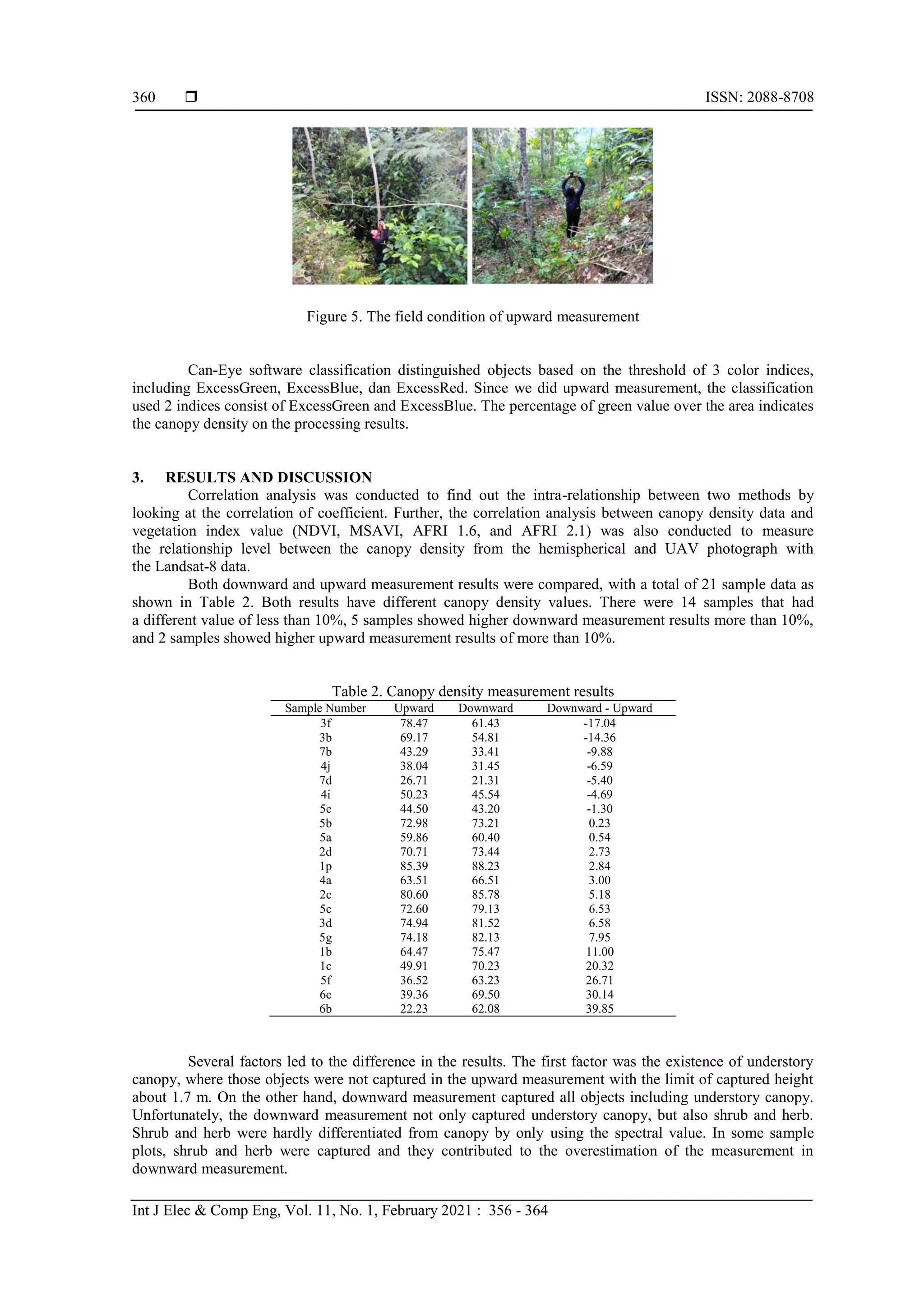
then the noise objects were cropped. The steep slope condition on some spots makes the vertically fish-eye
camera captured the slope as shown in Figure 5. This condition also occurred in the site near the building and
rooftop. As depicted in Figure 4, the building appeared on the photo. Slope and building are considered as
noises and have been cropped on the processing.
Figure 4. Upward classification process including selection, masking, and classification on sample 4a](https://image.slidesharecdn.com/3622681ce27jun14jun30mary-210319090031/75/Comparing-canopy-density-measurement-from-UAV-and-hemispherical-photography-an-evaluation-for-medium-resolution-of-remote-sensing-based-mapping-4-2048.jpg)
![Int J Elec & Comp Eng ISSN: 2088-8708
Comparing canopy density measurement from UAV and… (Deha Agus Umarhadi)
361
The overestimate canopy density measurement due to the involvement of shrub and herb could be
an advantage of the downward method for other applications such as erosion. However, the inclusion of
shrub and herb more likely represented vegetation density, not canopy density. Erosion study considers basal
area vegetation, such as dry leaves, grass, and other plant residues [33]. Downward canopy density
measurement is more reliable to measure vegetation density, although it also can obtain canopy density, and
it can be improved by masking the shrub and herb first.
The higher density in downward method was caused by the difficulty in classifying canopy object
and soil background. Almost all soil backgrounds were covered by canopy layers and shadows, hence most
of the tree crowns were classified as 100% of canopy. On the other hand, upward measurement was sensitive
to distinguish canopy and sky background, as a result, there was no 100% density in each crown.
The downward method term is closer to the definition of crown cover than canopy density [18].
Chianucci et al. [18] used true color (RGB) camera and mentioned that by using this method, and it was
difficult to detect small within-crown gaps that were, much closer to crown cover, although it accurately
quantified canopy cover. In this study, we used CIR camera. Although this camera includes a near-infrared
band, it displayed the same problem to detect small gaps. This pixel-based classification may be improved by
combining with point clouds derived canopy cover proposed by Khokthong et al. [19].
The hemispherical method has a different definition, according to Jennings [34], this method is used
to measure canopy closure which means the proportion of the sky obscured by vegetation when viewed from
a single point hemispherically. This definition is often used as the synonym of canopy density [34]. This term
is different from canopy closure, which used ortho-vertical projection. The results between canopy closure
and canopy cover are not necessarily correlated in the same area, because the height of the tree affects
the amount of canopy proportion.
Although they had different results, both methods, downward and upward constructed a strong
relationship. Correlation analysis showed that the 21 canopy density measurements from both methods
showed a 0.71 correlation coefficient which means they had a strong relationship. On the scatterplot graph as
shown in Figure 6, several samples showed that upward measurement value had a higher correlation of
coefficient than downward measurement, but based on the normal line, more plots were placed in
the proportion which indicates downward measurement results were higher than that of upward dominantly.
Figure 6. Plot of upward and downward measurement results
Canopy density estimation model in this study was constructed from vegetation index
transformation, hence we also compared the correlation of both canopy density methods. Correlation analysis
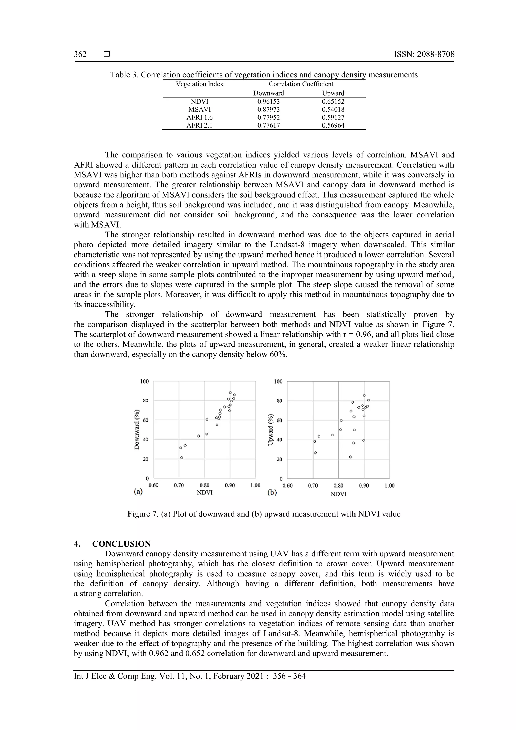
was applied in each method and each vegetation index. The correlation coefficients as shown in Table 3
showed the downward method possessed much stronger correlations on all of the vegetation indices
compared to the upward method. The relationship of both methods with NDVI was the strongest among other
vegetation indices, with the correlation in downward and upward measurements were 0.962 and 0.652,
respectively. This great correlation is mainly because NDVI has proven its capability in classifying land
cover by the approach of vegetation density and estimating canopy density using remote sensing data [35].
We also included other vegetation indices, and all of them indicated that downward method performed better
with higher correlation.](https://image.slidesharecdn.com/3622681ce27jun14jun30mary-210319090031/75/Comparing-canopy-density-measurement-from-UAV-and-hemispherical-photography-an-evaluation-for-medium-resolution-of-remote-sensing-based-mapping-6-2048.jpg)
![Int J Elec & Comp Eng ISSN: 2088-8708
Comparing canopy density measurement from UAV and… (Deha Agus Umarhadi)
363
UAV imagery in this study showed similarity with the Landsat-8 OLI and resembled high
relationships especially when downscaled into the resolution of the Landsat 8. The similar information in
both images resulted in a stronger correlation than the upward method. However, further adjustment by
improving the detection of small gaps between canopies can be used to increase the prediction accuracy of
using upward methods. Future study in improving the gaps detection in the upward method was deemed
necessary to improve the relationship with the remote sensing imagery.
ACKNOWLEDGEMENTS
Authors would like to thank Sanjiwana Arjasakusuma for proofreading the paper. We also thank
Ridho Dwi Dharmawan, Maulana Yudhinugroho, and Anisfa Andiyani for their helps in collecting field data.
REFERENCES
[1] C. Macfarlane, et al., “Estimation of Leaf Area Index in Eucalypt Forest Using Digital Photography,” Agricultural
and Forest Meteorology, vol. 143, no. 3-4, pp. 176-188, 2007.
[2] Z. Azizi, et al., “Forest Canopy Density Estimating, Using Satellite Images,” The International Archives of
the Photogrammetry, Remote Sensing and Spatial Information Sciences. vol. XXXVII, Part B8. Beijing, 2008.
[3] S. Arjasakusuma, et al., “Accuracy and Spatial Pattern Assessment of Forest Cover change Datasets in Central
Kalimantan,” Indonesian Journal of Geography, vol. 50, no. 2, pp. 222-227, 2018.
[4] N. R. Tohir, et al., “Pemetaan Perubahan Kerapatan Kanopi di Hutan Rakyat Kabupaten Kuningan Jawa Barat-
Mapping of Canopy Density Change in Community Forest, Kuningan District, West Java (In Bahasa),” Seminar
Nasional Penginderaan Jauh: Deteksi Parameter Geobiofisik dan Diseminasi Penginderaan Jauh, 322-331, 2014.
[5] F. Taureau, et al., “Mapping the Mangrove Forest Canopy Using Spectral Unmixing of Very High Spatial
Resolution Satellite Images,” Remote Sensing, vol. 11, no. 367, 2019.
[6] M. Kamal, et al., “Assessment of Mangrove Forest Degradation Through Canopy Fractional Cover in Karimunjawa
Island, Central Java, Indonesia,” Geoplanning: Journal of Geomatics and Planning, vol. 3, no. 2, pp. 107-116,
2016.
[7] S. Arjasakusuma, et al., “Local-Scale Accuracy Assessment of Vegetation Cover Change Maps Derived from
Global Forest Change Data, ClasLite, and Supervised Classifications: Case Study at Part of Riau Province,
Indonesia,” Applied Geomatics, vol. 10, no. 3, pp. 205-217, 2018.
[8] C. Li, Mingyang Li, and Yingchang Li, “Improving Estimation of Forest Aboveground Biomass Using Landsat 8
Imagery by Incorporating Forest Crown Density as a Dummy Variable,” Canadian Journal of Forest Research,
vol. 50, no. 4, pp. 390-398, 2020.
[9] R. N. Khairiah, et al., “Agroforestry Tree Density Estimation Based on Hemispherical Photos & Landsat 8
OLI/TIRS Image: a Case Study at Cidanau Watershed, Banten-Indonesia,” The International Archives of
the Photogrammetry, Remote Sensing and Spatial Information Sciences, vol. XLII-3/W7, 2019.
[10] J. C. Jiménez-Muñoz, et al., “Comparison Between Fractional Vegetation Cover Retrievals from Vegetation Indices
and Spectral Mixture Analysis: Case Study of PROBA/CHRIS Data Over an Agricultural Area,” Sensors, vol. 9,
pp. 768-793, 2014.
[11] A. Abdollahnejad, P Dimitrios, S Peter., “Forest Canopy Density Assessment Using Different Approaches –
Review,” Journal of Forest Science, vol. 63, pp. 106-115, 2017.
[12] F. Chianucci, U Chiavetta, A Cutini, “The Estimation of Canopy Attributes from Digital Cover Photography by
Two Different Image Analysis Methods,” iForest, vol. 7, pp. 255-259, 2014.
[13] F. Chianucci, “An Overview of In Situ Digital Canopy Photography in Forestry,” Canadian Journal of Forest
Research, vol. 50, no. 3, pp. 227-242, 2020.
[14] F. Chianucci and A. Cutini, “Digital Hemispherical Photography for Estimating Forest Canopy Properties: Current
Controversies and Opportunities,” iForest, vol. 5, pp. 290-295, 2012.
[15] F. Ashaari, M. Kamal, D. Dirgahayu, “Comparison of Model Accuracy in Tree Canopy Density Estimation Using
Single Band, Vegetation Indices and Forest Canopy Density (FCD) Based on Landsat-8 Imagery (Case Study: Peat
Swamp Forest in Riau Province),” Int. Journal of Remote Sensing and Earth Sciences, vol. 15, pp. 81-92, 2018.
[16] S. A. Suab and R. Avtar, “Unmanned Aerial Vehicle System (UAVS) Applications in Forestry and Plantation
Operations: Experiences in Sabah and Sarawak, Malaysian Borneo,” Unmanned Aerial Vehicle: Application in
Environment and Agriculture, R. Avtar and T. Watanabe (Eds.), Cham: Springer International Publishing, 2020.
[17] Y. Erfanifard and Z. Khodaee, “Canopy Density Mapping on Ultracam-D Aerial Imagery in Zagros Woodlands,
Iran,” International Archives of the Photogrammetry, Remote Sensing and Spatial Information Sciences,
vol. XL-1/W3, 2013 SMPR 2013, 2013.
[18] F. Chianucci, et al., “Estimation of Canopy Attributes in Beech Forests Using True Colour Digital Images from A
Small Fixed Wing UAV,” International Journal of Applied Earth Observation and Geoinformation, vol. 47,
pp. 60-68, 2016.
[19] W. Khokthong, et al., “Drone-Based Assessment of Canopy Cover for Analyzing Tree Mortality in an Oil Palm
Agroforest,” Frontiers in Forests and Global Change, vol. 2, no. 12, 2019.
[20] C. Huang, et al., “A Strategy for Estimating Tree Canopy Density Using Landsat 7 ETM+ and High Resolution
Images Over Large Area,” Third Int. Conference on Geospatial Information in Agriculture and Forestry, 2001.](https://image.slidesharecdn.com/3622681ce27jun14jun30mary-210319090031/75/Comparing-canopy-density-measurement-from-UAV-and-hemispherical-photography-an-evaluation-for-medium-resolution-of-remote-sensing-based-mapping-8-2048.jpg)
![ ISSN: 2088-8708
Int J Elec & Comp Eng, Vol. 11, No. 1, February 2021 : 356 - 364
364
[21] D. A. Umarhadi, et al., “The Comparison of Canopy Density Measurement Using UAV and Hemispherical
Photography for Remote Sensing Based Mapping,” 4th International Conference on Science and Technology
(ICST), pp. 1-5, 2018.
[22] R. D. Dimyati, et al., “A Minimum Cloud Cover Mosaic Image Model of the Operational Land Imager Landsat-8
Multitemporal Data using Tile based,” International Journal of Electrical and Computer Engineering (IJECE),
vol. 8, no. 1, pp. 360-371, 2018.
[23] M. Palmolina, “Pengelolaan Hutan Rakyat pada Lahan Sempit-Community Forest Management in Narrow Land
(in Bahasa),” Prosiding Seminar Nasional Masyarakat Biodiversitas Indonesia, pp. 732-737, 2015.
[24] S. Dhingra and D. Kumar, “A Review of Remotely Sensed Satellite Image Classification,” International Journal of
Electrical and Computer Engineering (IJECE), vol. 9, no. 3, pp. 1720-1731, 2019.
[25] M. Xu, X Jia, M Pickering., “Automatic Cloud Removal for Landsat 8 OLI Images Using Cirrus Band,” IEEE
Geoscience and Remote Sensing Symposium, pp. 2511-2514, 2014.
[26] D. A. Umarhadi and P. Danoedoro, "Correcting topographic effect on Landsat-8 images: an evaluation of using
different DEMs in Indonesia," Proc. SPIE 11311, Sixth Geoinformation Science Symposium, 2019.
[27] W. Rouse, et al., “Monitoring Vegetation Systems in the Great Plains with ERTS,” Proc. Third Earth Resources
Technology Satellite-1 Symposium, SP-351, 3010-3017, 1974.
[28] J. Qi, et al., “A Modified Soil Adjusted Vegetation Index,” Remote Sensing of Environment, vol. 48, no. 2,
pp. 119-126, 1994.
[29] A. Karnieli, et al., “AFRI-Aerosol Free Vegetation Index,” Remote Sensing of Environment, vol. 77, no. 1,
pp. 10-21, 2001.
[30] R. M. McCoy, “Field Methods in Remote Sensing,” The Guilford Press A Division of Guilford Publications, 2005.
[31] H. Zheng, et al., “Evaluation of RGB, Color-Infrared and Multispectral Images Acquired from Unmanned Aerial
Systems for the Estimation of Nitrogen Accumulation in Rice,” Remote Sensing, vol. 10, no. 6, 2018.
[32] M. Weiss and F. Baret, “Can Eye V6.4.91 User Manual,” INRA Science & Impact, 2017.
[33] D. D. Gupita and S. H. M. B. Santosa, “Soil Erosion and Its Correlation with Vegetation Cover: An Assessment
Using Multispectral Imagery and Pixel-Based Geographic Information System in Gesing Sub-Watershed, Central
Java, Indonesia,” IOP Conf. Series: Earth and Environmental Science, vol. 54, no. 1, 2017.
[34] S. B. Jennings, ND Brown, D Sheil., “Assessing Forest Canopies and Understorey Illumination: Canopy Closure,
Canopy Cover and Other Measures,” Forestry, vol. 72, no. 1, pp. 59-74, 1999.
[35] M. Kamal, S Phinn, K Johansen, “Characterizing the Spatial Structure of Mangrove Features for Optimizing
Image-Based Mangrove Mapping,” Remote Sensing, vol. 6, no. 2, pp. 984-1006, 2014.
BIOGRAPHIES OF AUTHORS
Deha Agus Umarhadi, was born in Yogyakarta. He obtained his B.Sc of Cartography and
Remote Sensing in Faculty of Geography, Universitas Gadjah Mada in 2017. He was a research
assistant at Center for Remote Sensing and Integrated Surveys (PUSPICS), Faculty of
Geography, Universitas Gadjah Mada (2017-2019). Currently, he is a master’s student at
Graduate School of Environmental Science, Faculty of Environmental Earth Science, Hokkaido
University.
Projo Danoedoro, was born in Yogyakarta. He obtained his B.Sc in the field of Technical
Geography/Remote Sensing in Faculty of Geography, Universitas Gadjah Mada in 1989, and
M.Sc from the Department of Land Resources and Urban Science (LARUS), Rural Land
Ecology Survey Division, ITC in 1993. He obtained his Ph.D in Centre for Remote Sensing and
Spatial Information Science (CRSSIS), The University of Queensland (UQ), Australia (2007).
He was the Director of Center for Remote Sensing and Integrated Surveys (PUSPICS) (2008-
2017). Currently, he is the Head of Remote Sensing Laboratory, and the Head of Remote
Sensing and GIS Graduate Program, Faculty of Geography, Universitas Gadjah Mada.](https://image.slidesharecdn.com/3622681ce27jun14jun30mary-210319090031/75/Comparing-canopy-density-measurement-from-UAV-and-hemispherical-photography-an-evaluation-for-medium-resolution-of-remote-sensing-based-mapping-9-2048.jpg)


![Earth Science and Remote Sensing Applications [Book]](https://cdn.slidesharecdn.com/ss_thumbnails/earthscienceandremotesensingapplicationsvol432018springer-180222222235-thumbnail.jpg?width=640&height=640&fit=bounds)