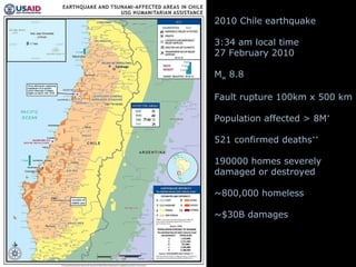
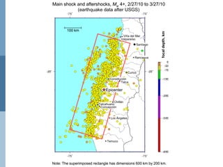
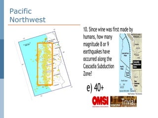
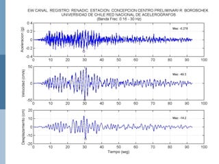
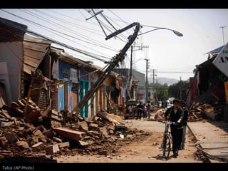
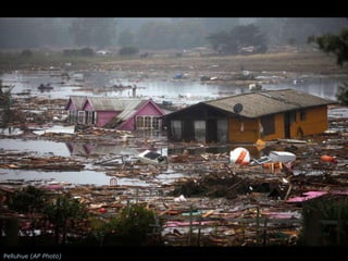
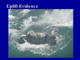
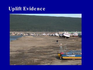
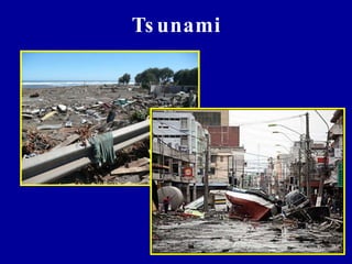
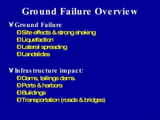
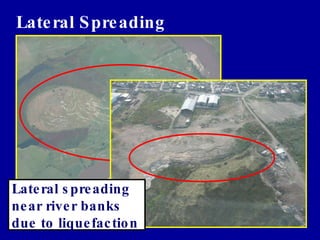
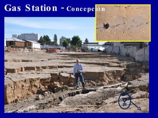
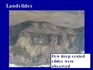
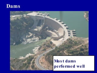
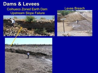
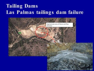
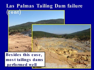
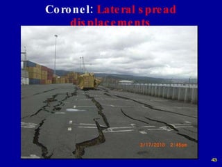
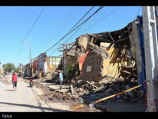
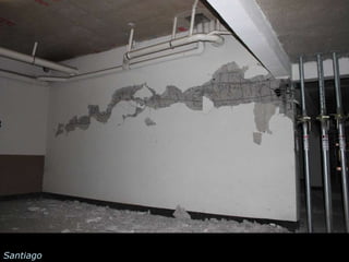
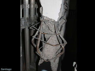
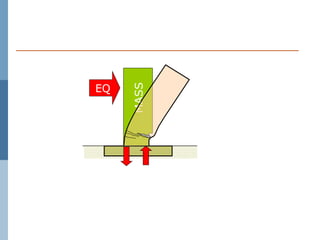
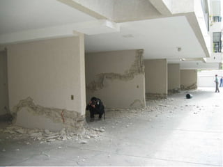
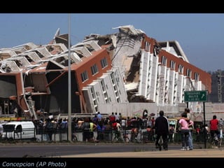
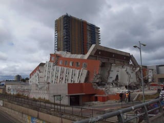
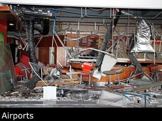
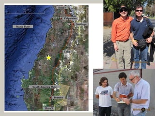
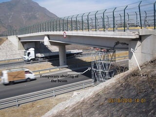
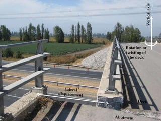
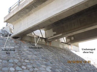
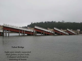
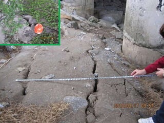
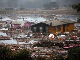
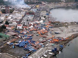
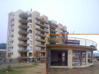
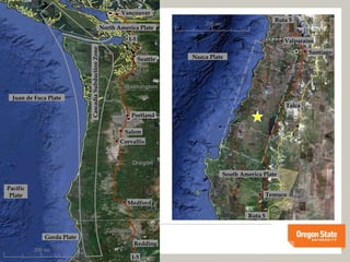
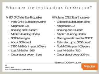
27 February 2010 South Central Chile Earthquake Professor Scott Ashford Oregon State University Professor Jack Moehle University of California at Berkeley Professor Pedro Arduino University of Washington
Acknowledgments for this broad collaborative effort funded primarily by the National Science Foundation Earthquake Engineering Research Institute (EERI) Jack Moehle, Team Leader Geo-Engineering Extreme Events Reconnaissance (GEER) Jon Bray, Team Leader Broad participation from Chilean Faculty and Students Pontifica Universidad Catolica de Chile University de Chile Over 100 other volunteers from around the world
movie
2010 Chile earthquake 3:34 am local time 27 February 2010 M w  8.8 Fault rupture 100km x 500 km Population affected > 8M * 521 confirmed deaths ** 190000 homes severely  damaged or destroyed ~800,000 homeless ~$30B damages *  ACHISINA ** USAID, 3/25/10
 
Pacific Northwest
 
Concepcion
Talca  (AP Photo)
Santiago  (AP PHOTO/Carlos Espinoza)
Pelluhue ( AP Photo)
Learning from Chile Geological and Geotechnical Aspects 27 February 2010 South Central Chile Earthquake June 28, 2010
Typical Subduction Zone
Recent Seismic Events Previous Events - Seismic Gap 1960-M9.5 1985-M8.0
Measured (GPS) Coseismic  Horizontal Displacements Concepcion moved ~3m towards west
Coseismic  Vertical Displacements Uplift up to ~2m was recorded in Lebu
Uplift Evidence
Uplift Evidence
Tsunami
Ground Failure Overview Ground Failure Site effects & strong shaking Liquefaction Lateral spreading Landslides Infrastructure impact: Dams, tailings dams. Ports & harbors Buildings Transportation (roads & bridges)
SITE EFFECTS Ground Failure
Site Effects: Vespucio Norte & Ciudad Empresiarial H/V peaks: 0.5-2sec  (Bonnefoy et al, 2008) Damage to 5 to 20-story buildings Q fno : Silt & Clay Layers Localized Damage – Site Effects? A B A B Gravel, Sandy gravel Silty Clay, Silty Sand Collapse No collapse
LIQUEFACTION & LATERAL SPREADING Ground Failure
Lateral Spreading Lateral spreading near river banks due to liquefaction
Gas Station -  Concepción
LANDSLIDES &  DAMS/TAILING DAMS Ground Failure
Landslides Few deep seated slides were observed
Dams Most dams performed well
Dams & Levees Coihueco Zoned Earth Dam  Upstream Slope Failure Levee Breach
Tailing Dams Las Palmas tailings dam failure Approximate area of failure and flow direction
Las Palmas Tailing Dam failure (cont) Besides this case, most tailings dams  performed well
PORTS & HARBORS CASE STUDIES Impacts of Ground Failure
Ports & Harbors Provide important means for importing & exporting goods in Chile 95% of exports & 90% of imports are conducted through ports Country has 35 operational ports (10 state owned, 25 privately owned). 2 are military ports 4 ports were inspected in the period 3/13 to 3/18 by GEER team: Valparaiso, San Antonio, Talcahuano & Coronel Information & Assistance was provided by EERI team and local engineers.
Valparaiso:  Outward quay wall movement and pavement cracks
San Antonio:  Damaged dock
Talcahuano Port Area St Vincente Port Fishing Wharf Fish Packaging Facility Petroleum Facilities N
Fishing Pier 178m 24m 42m N Documented extent of lateral spread
N Approx extent of lateral spread
Lateral Spreading Effects on Industrial Facilities Fish Packing Facility, San Vicente
Petrobas Gas Facility  N Fish Packaging Facility Petrobas Gas Facility Water rise  Approx extent of lateral spread
Coronel:  Lateral spread displacements
Coronel:  Sinkholes   (2.2m deep, 3.5m in diameter)
Coronel:  Rotation of pile due to lateral spreading (not a raked pile!)
EMBANKMENT FAILURES Impacts of Ground Failure
Embankment Failures along Highway 5 Possible liquefaction  of thin seams in  foundation soils led  to translational  failures of  highway embankments
Talca
Talca
Valparaiso,  UNESCO Heritage City
Talca
 
Festival Viña del Mar, 14 Stories
MASS EQ
Santiago
Santiago
Santiago
MASS EQ
 
Concepcion (AP Photo)
 
Collapsed building in Concepcion openings solid typical unit Plan Tower under construction parking A B Section A Section B
 
Santiago
Santiago
Airports
Hospitals and health care
US$2 billion annual sales Approx. 1 billion liters  70% exported 80,000 full-time workers Chilean Wine Industry
 
Stainless steel tanks
Thank You
Santiago  (AP PHOTO/Carlos Espinoza)
Bridge Team Members Mark Yashinsky, Team Leader Caltrans Rodrigo Oviedo Universidad Catolica de Chile Scott Ashford Oregon State University Luis Fargier-Gabaldon Universidad de los Andes, Merida . Matias Hube Universidad Catolica de Chile Traveled over 2000 km from Santiago to Temuco and back over 5 days Nazca Plate 200 mi Valparaíso South America Plate Temuco Talca Ruta 5 Ruta 5 Santiago
shear key Temporary shoring of the beam
Vertical axis Rotation or twisting of the deck Abutment Deck Lateral displacement
Failed shear key  Seismic bars Undamaged shear key
Tubul Bridge Eight span simply supported steel girders on pier walls. Collapsed attributed to unseating of beams
 
 
Summary of Observations on Bridges Structures with less continuity generally suffered more damage Localized damage suggests the importance of local site effects Significant liquefaction and lateral spreading along coast greatly impacted mobility Widespread fill settlement was easily repaired, but adversely affected traffic.
Summary of other Lifeline Performance Electric Power Immediate blackout to 90% of Chile’s population Transmission capability to provide power within 24 hours Distribution system service restored with two weeks Telecommunication Both landlines and wireless service serverly affected Most cell sites ran out of battery power within 3 hours of quakes, eliminating communications with repair crews and hospitals Most services restored within seven days Water and Wastewater severely impacted along coast
Pelluhue ( AP Photo)
Maximum inundation 10m Maximum run-up 30m Loss of life limited thanks to local awareness and good signing Most tsunami-related deaths from tourists Tsunami
NOAA Tsunami wave heights for Feb. 27, 2010, 8.8 EQ
NOAA Tsunami wave heights, May 22 1960, 9.5 EQ
1500 homes destroyed in Dichato from tsunami; only 17 residents killed


Where do we fit in? The Pacific “Ring of Fire”
200 mi Juan de Fuca Plate Cascadia Subduction Zone Oregon Washington California Gorda Plate Pacific Plate North America Plate Seattle Portland Corvallis Salem Redding Medford Vancouver I-5 I-5 Nazca Plate 200 mi Valparaíso South America Plate Temuco Talca Ruta 5 Ruta 5 Santiago
Comparison of Haiti and Chile earthquakes Haiti was: Magnitude 7.0 Shallow Strike-Slip under urban area Vulnerable infrastructure Chile was: Magnitude 8.8 Subduction Zone EQ  covering huge area Over 500 more powerful Last 6 times as long Less vulnerable infrastructure Chile Haiti Finite fault models by Gavin Hayes, USGS National Earthquake Information Center
What are the implications for Oregon? 2010 Chile Earthquake Peru-Chile Subduction Zone Magnitude 8.8 Shaking and Tsunami Modern Building Codes $30B damages About 500 dead 7 EQ M=8.0+ in past 100 yrs Last M=8.0 in 1995 Occur about every 15 yrs Future CSZ Earthquake Cascadia Subduction Zone Magnitude 9.0 Shaking and Tsunami Modern Building Codes Damages estimated at $30B* Estimated up to 5000 dead* No M=7.0 is past 100 years Last M=9.0 in 1700 Occur about every 300 yrs *Source: DOGAMI 2010
What can you do? Take personal responsibility Have several days of emergency supplies Earthquake proof your home  Have a plan Support earthquake preparedness efforts Participate in earthquake education  Continue to support State efforts DOGAMI tsunami hazard mapping to be completed by 2013 Seismic mitigation of public schools not complete until 2032 ODOT Phase I and II seismic retrofits Support higher education Innovative solutions through research and next-generation engineers
THANK YOU! For more information: Earthquake Engineering Research Institute www.eeri.org Geo-Engineering Extreme Events Reconnaissance www.geerassociation.org Oregon Department of Geology and Mineral Industries www.OregonGeology.org

OMSI Science Pub - Chile Earthquake

  • 1.
    27 February 2010South Central Chile Earthquake Professor Scott Ashford Oregon State University Professor Jack Moehle University of California at Berkeley Professor Pedro Arduino University of Washington
  • 2.
    Acknowledgments for thisbroad collaborative effort funded primarily by the National Science Foundation Earthquake Engineering Research Institute (EERI) Jack Moehle, Team Leader Geo-Engineering Extreme Events Reconnaissance (GEER) Jon Bray, Team Leader Broad participation from Chilean Faculty and Students Pontifica Universidad Catolica de Chile University de Chile Over 100 other volunteers from around the world
  • 3.
  • 4.
    2010 Chile earthquake3:34 am local time 27 February 2010 M w 8.8 Fault rupture 100km x 500 km Population affected > 8M * 521 confirmed deaths ** 190000 homes severely damaged or destroyed ~800,000 homeless ~$30B damages * ACHISINA ** USAID, 3/25/10
  • 5.
  • 6.
  • 7.
  • 8.
  • 9.
    Talca (APPhoto)
  • 10.
    Santiago (APPHOTO/Carlos Espinoza)
  • 11.
  • 12.
    Learning from ChileGeological and Geotechnical Aspects 27 February 2010 South Central Chile Earthquake June 28, 2010
  • 13.
  • 14.
    Recent Seismic EventsPrevious Events - Seismic Gap 1960-M9.5 1985-M8.0
  • 15.
    Measured (GPS) Coseismic Horizontal Displacements Concepcion moved ~3m towards west
  • 16.
    Coseismic VerticalDisplacements Uplift up to ~2m was recorded in Lebu
  • 17.
  • 18.
  • 19.
  • 20.
    Ground Failure OverviewGround Failure Site effects & strong shaking Liquefaction Lateral spreading Landslides Infrastructure impact: Dams, tailings dams. Ports & harbors Buildings Transportation (roads & bridges)
  • 21.
  • 22.
    Site Effects: VespucioNorte & Ciudad Empresiarial H/V peaks: 0.5-2sec (Bonnefoy et al, 2008) Damage to 5 to 20-story buildings Q fno : Silt & Clay Layers Localized Damage – Site Effects? A B A B Gravel, Sandy gravel Silty Clay, Silty Sand Collapse No collapse
  • 23.
    LIQUEFACTION & LATERALSPREADING Ground Failure
  • 24.
    Lateral Spreading Lateralspreading near river banks due to liquefaction
  • 25.
    Gas Station - Concepción
  • 26.
    LANDSLIDES & DAMS/TAILING DAMS Ground Failure
  • 27.
    Landslides Few deepseated slides were observed
  • 28.
    Dams Most damsperformed well
  • 29.
    Dams & LeveesCoihueco Zoned Earth Dam Upstream Slope Failure Levee Breach
  • 30.
    Tailing Dams LasPalmas tailings dam failure Approximate area of failure and flow direction
  • 31.
    Las Palmas TailingDam failure (cont) Besides this case, most tailings dams performed well
  • 32.
    PORTS & HARBORSCASE STUDIES Impacts of Ground Failure
  • 33.
    Ports & HarborsProvide important means for importing & exporting goods in Chile 95% of exports & 90% of imports are conducted through ports Country has 35 operational ports (10 state owned, 25 privately owned). 2 are military ports 4 ports were inspected in the period 3/13 to 3/18 by GEER team: Valparaiso, San Antonio, Talcahuano & Coronel Information & Assistance was provided by EERI team and local engineers.
  • 35.
    Valparaiso: Outwardquay wall movement and pavement cracks
  • 36.
    San Antonio: Damaged dock
  • 37.
    Talcahuano Port AreaSt Vincente Port Fishing Wharf Fish Packaging Facility Petroleum Facilities N
  • 39.
    Fishing Pier 178m24m 42m N Documented extent of lateral spread
  • 40.
    N Approx extentof lateral spread
  • 41.
    Lateral Spreading Effectson Industrial Facilities Fish Packing Facility, San Vicente
  • 42.
    Petrobas Gas Facility N Fish Packaging Facility Petrobas Gas Facility Water rise Approx extent of lateral spread
  • 43.
    Coronel: Lateralspread displacements
  • 44.
    Coronel: Sinkholes (2.2m deep, 3.5m in diameter)
  • 45.
    Coronel: Rotationof pile due to lateral spreading (not a raked pile!)
  • 46.
    EMBANKMENT FAILURES Impactsof Ground Failure
  • 47.
    Embankment Failures alongHighway 5 Possible liquefaction of thin seams in foundation soils led to translational failures of highway embankments
  • 48.
  • 49.
  • 50.
    Valparaiso, UNESCOHeritage City
  • 51.
  • 52.
  • 53.
    Festival Viña delMar, 14 Stories
  • 54.
  • 55.
  • 56.
  • 57.
  • 58.
  • 59.
  • 60.
  • 61.
  • 62.
    Collapsed building inConcepcion openings solid typical unit Plan Tower under construction parking A B Section A Section B
  • 63.
  • 64.
  • 65.
  • 66.
  • 67.
  • 68.
    US$2 billion annualsales Approx. 1 billion liters 70% exported 80,000 full-time workers Chilean Wine Industry
  • 69.
  • 70.
  • 71.
  • 72.
    Santiago (APPHOTO/Carlos Espinoza)
  • 73.
    Bridge Team MembersMark Yashinsky, Team Leader Caltrans Rodrigo Oviedo Universidad Catolica de Chile Scott Ashford Oregon State University Luis Fargier-Gabaldon Universidad de los Andes, Merida . Matias Hube Universidad Catolica de Chile Traveled over 2000 km from Santiago to Temuco and back over 5 days Nazca Plate 200 mi Valparaíso South America Plate Temuco Talca Ruta 5 Ruta 5 Santiago
  • 74.
    shear key Temporaryshoring of the beam
  • 75.
    Vertical axis Rotationor twisting of the deck Abutment Deck Lateral displacement
  • 76.
    Failed shear key Seismic bars Undamaged shear key
  • 77.
    Tubul Bridge Eightspan simply supported steel girders on pier walls. Collapsed attributed to unseating of beams
  • 78.
  • 79.
  • 80.
    Summary of Observationson Bridges Structures with less continuity generally suffered more damage Localized damage suggests the importance of local site effects Significant liquefaction and lateral spreading along coast greatly impacted mobility Widespread fill settlement was easily repaired, but adversely affected traffic.
  • 81.
    Summary of otherLifeline Performance Electric Power Immediate blackout to 90% of Chile’s population Transmission capability to provide power within 24 hours Distribution system service restored with two weeks Telecommunication Both landlines and wireless service serverly affected Most cell sites ran out of battery power within 3 hours of quakes, eliminating communications with repair crews and hospitals Most services restored within seven days Water and Wastewater severely impacted along coast
  • 82.
  • 83.
    Maximum inundation 10mMaximum run-up 30m Loss of life limited thanks to local awareness and good signing Most tsunami-related deaths from tourists Tsunami
  • 84.
    NOAA Tsunami waveheights for Feb. 27, 2010, 8.8 EQ
  • 85.
    NOAA Tsunami waveheights, May 22 1960, 9.5 EQ
  • 86.
    1500 homes destroyedin Dichato from tsunami; only 17 residents killed
  • 87.
  • 88.
  • 89.
  • 90.
    Where do wefit in? The Pacific “Ring of Fire”
  • 91.
    200 mi Juande Fuca Plate Cascadia Subduction Zone Oregon Washington California Gorda Plate Pacific Plate North America Plate Seattle Portland Corvallis Salem Redding Medford Vancouver I-5 I-5 Nazca Plate 200 mi Valparaíso South America Plate Temuco Talca Ruta 5 Ruta 5 Santiago
  • 92.
    Comparison of Haitiand Chile earthquakes Haiti was: Magnitude 7.0 Shallow Strike-Slip under urban area Vulnerable infrastructure Chile was: Magnitude 8.8 Subduction Zone EQ covering huge area Over 500 more powerful Last 6 times as long Less vulnerable infrastructure Chile Haiti Finite fault models by Gavin Hayes, USGS National Earthquake Information Center
  • 93.
    What are theimplications for Oregon? 2010 Chile Earthquake Peru-Chile Subduction Zone Magnitude 8.8 Shaking and Tsunami Modern Building Codes $30B damages About 500 dead 7 EQ M=8.0+ in past 100 yrs Last M=8.0 in 1995 Occur about every 15 yrs Future CSZ Earthquake Cascadia Subduction Zone Magnitude 9.0 Shaking and Tsunami Modern Building Codes Damages estimated at $30B* Estimated up to 5000 dead* No M=7.0 is past 100 years Last M=9.0 in 1700 Occur about every 300 yrs *Source: DOGAMI 2010
  • 94.
    What can youdo? Take personal responsibility Have several days of emergency supplies Earthquake proof your home Have a plan Support earthquake preparedness efforts Participate in earthquake education Continue to support State efforts DOGAMI tsunami hazard mapping to be completed by 2013 Seismic mitigation of public schools not complete until 2032 ODOT Phase I and II seismic retrofits Support higher education Innovative solutions through research and next-generation engineers
  • 95.
    THANK YOU! Formore information: Earthquake Engineering Research Institute www.eeri.org Geo-Engineering Extreme Events Reconnaissance www.geerassociation.org Oregon Department of Geology and Mineral Industries www.OregonGeology.org

Editor's Notes

  • #11 Santiago
  • #19 Lebu ~2m uplift
  • #29 Rapel
  • #32 Las Palmas Tailings dam
  • #40 Fishing pier suffered lateral spread, boats still docking at pier – however fish cleaning and packaging facility totally destroyed, therefore fishing production stopped altogether here – neighboring st vincente international port, damage due to liquefaction and lateral spreading
  • #50 Tower leaning, flying buttresses failed
  • #51 maffei noel nathan lecture 8april2009 eq damage & retrofitmaffei seaonc seminar eq damage and retrofit concrete 07/20/10
  • #63 Highway near Santiago
  • #73 Santiago
  • #74 What are the lessons for Caltrans, for US bridge engineers, and for Chilean bridge engineers?
  • #75 Overcrossing along Route 5 about 43 km south of Santiago
  • #77 The excessive transverse movement at the abutment caused this I-girder to come off the abutment seat. Note that the short abutment results in the girder coming to rest on the embankment slope armor. The effectiveness of seismic bars was not readily apparent. Note the lack of diaphragm between girders.
  • #79 Ground cracking and slope movement towards Rio Bio Bio underneath north abutment of Puente Llacolen shown in previous slide. Liquefaction between bridge shown in inset.
  • #85 This NOAA simulation shows the open ocean maximum wave heights predicted for the February 27, 2010 Chile earthquake. The extreme wave heights are limited to a short section along the Chilean coastline, and dissipate rapidly as the waves travel across the Pacific Ocean. The effects in Hawaii, West Coast USA, and Japan were limited to a series of rapid tidal changes on the order of 3 to 4 feet.
  • #86 For comparison, this NOAA simulation shows the open ocean maximum wave heights predicted for the May 22, 1960 Chile earthquake. This was a considerably larger earthquake, and larger tsunami event. The local tsunami was more widespread, and lead to 2000 deaths in Chile, while the trans-pacific tsunami waves resulted in deaths in Hawaii, Japan and the Philippines.