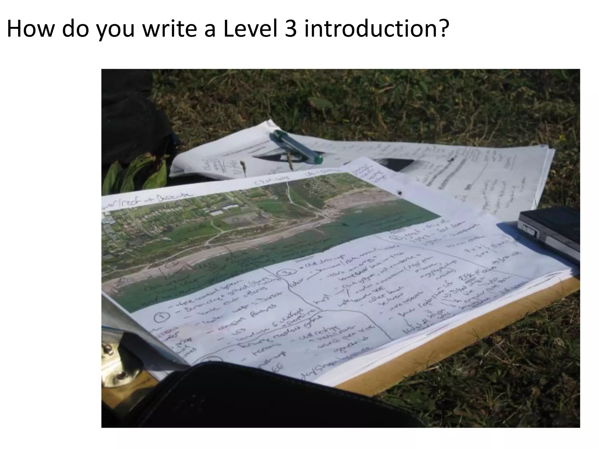
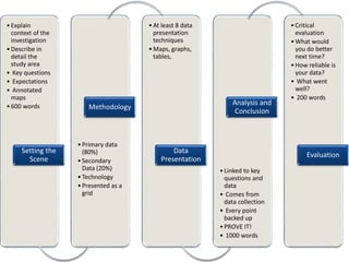
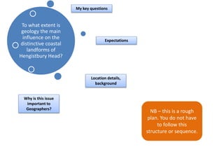
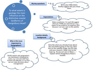
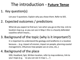
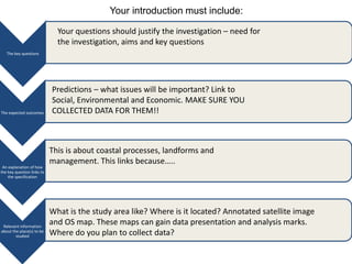
How do you write a Level 3 introduction?
• Explain 
context of the 
investigation 
• Describe in 
detail the 
study area 
• Key questions 
• Expectations 
• Annotated 
maps 
• 600 words 
Setting the 
Scene 
Methodology 
• Primary data 
(80%) 
• Secondary 
Data (20%) 
• Technology 
• Presented as a 
grid 
•At least 8 data 
presentation 
techniques 
•Maps, graphs, 
tables, 
Data 
Presentation 
Analysis and 
Conclusion 
• Linked to key 
questions and 
data 
• Comes from 
data collection 
• Every point 
backed up 
• PROVE IT! 
• 1000 words 
• Critical 
evaluation 
•What would 
you do better 
next time? 
•How reliable is 
your data? 
• What went 
well? 
• 200 words 
Evaluation
To what extent is 
geology the main 
influence on the 
distinctive coastal 
landforms of 
Hengistbury Head? 
My key questions 
Location details, 
background 
Why is this issue 
important to 
Geographers? 
Expectations 
NB – this is a rough 
plan. You do not have 
to follow this 
structure or sequence.
To what extent is 
geology the main 
influence on the 
distinctive coastal 
landforms of 
Hengistbury Head? 
My key questions 
Location details, 
background 
Why is this issue 
important to 
Geographers? 
Expectations 
Write your 5KQs down. 
Briefly suggest why you chose 
them. 
Make a prediction. For each KQ suggest 
what you THINK you will find out. E.g. I 
expect to see evidence of longshore drift 
because I can see a spit on the satellite 
image. 
Describe what you already know about 
the area before going on the trip. Base 
this on the satellite image, the OS map, 
and your research. Make links to the 
map e.g. ‘As you can see on Map 1….’ 
Explain where Hengistbury Head is 
Briefly explain why geographers located. 
are interested in studying the 
coast, e.g. is it to do with how 
humans are effected, is it so that 
we can make decisions about 
management?
The mark scheme; 
Application of Knowledge and Understanding 
Study the mark scheme. 
Identify the points for the introduction 
Identify the difference between L2 + L3
Level 3 criteria: What does the markscheme say? What is that to me? 
AO2 
Application of 
knowledge and 
understanding in 
familiar and 
unfamiliar contexts 
• They have applied their knowledge and understanding of 
the question/hypothesis to describe the enquiry in a wide 
range and variety of contexts. 
• They have applied their knowledge and understanding to 
suggest in detail a range of expected outcomes of their 
enquiry with justifications. 
• They have used detailed and complex information to 
describe the place(s) chosen as a focus for the enquiry. 
• They have used their knowledge and understanding to 
describe and explain their evidence in a consistently detailed 
way. 
SETTING THE SCENE 
• 5 key questions linked to the main enquiry question: ‘What is 
distinctive about Hengistbury Head?’ 
• Setting the Scene gives detailed predictions, linked to theory 
and map / satellite image evidence and knowledge of Barton 
on Sea / Highcliffe. E.g. LSD theory, coastal management, 
land use linked to leisure and tourism. What do you expect 
to find out? 
• HH described in writing, including co-ordinates. Annotated 
OS map and annotated satellite image describing location 
and making predictions. All annotations linked to key 
questions. 
• Distinctive defined and linked to coast. 
Analysis and Conclusion 
• Describe in detail using PEED every piece of data using 
evidence captured on the day to support. 
17-24 marks 
AO3 
Selection and use of 
a variety 
of skills, techniques 
and 
technologies to 
investigate, 
analyse and evaluate 
questions and issues: 
selection, 
investigation and 
presentation 
• They have suggested a wide variety of techniques and 
technologies that are consistently appropriate to undertake 
their enquiry with detailed justification of why these have 
been chosen. 
• They have collected and accurately recorded a range of 
appropriate evidence from a wide range of sources, mainly 
fieldwork. 
• They have presented their data in a wide range of 
appropriate maps, graphs and diagrams. 
• Their written work is legible and spelling, grammar and 
punctuation are accurate. Meaning is communicated clearly. 
• They have written with precision and succinctness, so that 
they do not exceed the prescribed word limit. 
Methodology and Fieldtrip 
• At least 5 techniques used. At least1 uses technology 
(photos. GE, Fotobabble, Photosynth). OWN TECHNIQUE 
PLANNED e.g. car park survey. 
• Methodology grid lists each technique, describes how data 
was collected, describes the problems faced and the 
solutions taken on the day and suggests a way of doing it 
better next time. All techniques are linked to a key question. 
• Field notebook adapted to key questions. 
• Field notebook complete during the field visit and included 
as an appendices. 5-10% secondary evidence to support 
(e.gf. HH shoreline management plan; price of beach huts; 
news reports) 
• At least 8 different, complex, data presentation techniques. 
NO bar or pie charts. 
• 2000 words in total. 
• No waffle – PEEL. No BANNED WORDS, named groups of 
people and geographical terms used. 
13-18 marks 
AO3 
Selection and use of 
a variety 
of skills, techniques 
and 
technologies to 
investigate, 
analyse and evaluate 
questions and issues: 
analysis 
and evaluation 
• They have critically analysed and thoroughly interpreted 
their evidence. 
• They have used this analysis and interpretation to draw an 
appropriate and substantiated conclusion. 
• They have made a critical evaluation of the success and 
usefulness of their enquiry. 
• They have analysed thoroughly the range of limitations to 
their enquiry. 
• They have made reasoned suggestions for possible 
solutions and extensions to their enquiry. 
Analysis 
• The data that you have found is linked back to your key 
questions. Suggest links to your predictions and theory – 
did you find out what you expected or something different? 
• Conclusion answers the main question ‘What is distinctive 
about HH?’ and is supported by the evidence that you 
have presented. 
• What went well with your enquiry? What could be better next 
time? 
• How reliable and accurate is your conclusion? Why? 
• Say how you would make the project (not the methodology) 
better. 
13-18 marks 
Total 60 Marks
What do examiners 
look for? 
Links to theory & 
keywords 
Links to processes 
Importance / 
impacts 
Social 
Economic 
Environmental links
The introduction - Future Tense 
1. Key question(s) 
List your 5 questions. Explain why you chose them. Refer to SEE. 
2. Expected outcomes / predictions 
What do you expect to find out / see when you go on the trip. Link to 
location map e.g. as you can see in Map 1 this is a heavily defended 
coastline which means… 
3. Background of the topic (why is it important?) 
It is important to understand the geology and landforms in a location 
because…. (e.g. impact of erosion, impact on people, planning coastal 
management, influences how people use an area, etc,.) 
4. Background of the place 
SSSI, Headland, Spit, Written location, refer to map evidence, link to 
your maps (e.g. ‘as you can see in map 1…..’)
Your introduction must include: 
The key questions 
The expected outcomes 
An explanation of how 
the key question links to 
the specification 
Relevant information 
about the place(s) to be 
studied 
Your questions should justify the investigation – need for 
the investigation, aims and key questions 
Predictions – what issues will be important? Link to 
Social, Environmental and Economic. MAKE SURE YOU 
COLLECTED DATA FOR THEM!! 
This is about coastal processes, landforms and 
management. This links because….. 
What is the study area like? Where is it located? Annotated satellite image 
and OS map. These maps can gain data presentation and analysis marks. 
Where do you plan to collect data?
Homework 
• Date: 
• Produce your draft introduction 
– Email to me or hand in 
– Attend workshop for support 
– Also bring in 2 photos to annotate

Eggars setting the scene

  • 1.
    How do youwrite a Level 3 introduction?
  • 2.
    • Explain contextof the investigation • Describe in detail the study area • Key questions • Expectations • Annotated maps • 600 words Setting the Scene Methodology • Primary data (80%) • Secondary Data (20%) • Technology • Presented as a grid •At least 8 data presentation techniques •Maps, graphs, tables, Data Presentation Analysis and Conclusion • Linked to key questions and data • Comes from data collection • Every point backed up • PROVE IT! • 1000 words • Critical evaluation •What would you do better next time? •How reliable is your data? • What went well? • 200 words Evaluation
  • 4.
    To what extentis geology the main influence on the distinctive coastal landforms of Hengistbury Head? My key questions Location details, background Why is this issue important to Geographers? Expectations NB – this is a rough plan. You do not have to follow this structure or sequence.
  • 5.
    To what extentis geology the main influence on the distinctive coastal landforms of Hengistbury Head? My key questions Location details, background Why is this issue important to Geographers? Expectations Write your 5KQs down. Briefly suggest why you chose them. Make a prediction. For each KQ suggest what you THINK you will find out. E.g. I expect to see evidence of longshore drift because I can see a spit on the satellite image. Describe what you already know about the area before going on the trip. Base this on the satellite image, the OS map, and your research. Make links to the map e.g. ‘As you can see on Map 1….’ Explain where Hengistbury Head is Briefly explain why geographers located. are interested in studying the coast, e.g. is it to do with how humans are effected, is it so that we can make decisions about management?
  • 6.
    The mark scheme; Application of Knowledge and Understanding Study the mark scheme. Identify the points for the introduction Identify the difference between L2 + L3
  • 7.
    Level 3 criteria:What does the markscheme say? What is that to me? AO2 Application of knowledge and understanding in familiar and unfamiliar contexts • They have applied their knowledge and understanding of the question/hypothesis to describe the enquiry in a wide range and variety of contexts. • They have applied their knowledge and understanding to suggest in detail a range of expected outcomes of their enquiry with justifications. • They have used detailed and complex information to describe the place(s) chosen as a focus for the enquiry. • They have used their knowledge and understanding to describe and explain their evidence in a consistently detailed way. SETTING THE SCENE • 5 key questions linked to the main enquiry question: ‘What is distinctive about Hengistbury Head?’ • Setting the Scene gives detailed predictions, linked to theory and map / satellite image evidence and knowledge of Barton on Sea / Highcliffe. E.g. LSD theory, coastal management, land use linked to leisure and tourism. What do you expect to find out? • HH described in writing, including co-ordinates. Annotated OS map and annotated satellite image describing location and making predictions. All annotations linked to key questions. • Distinctive defined and linked to coast. Analysis and Conclusion • Describe in detail using PEED every piece of data using evidence captured on the day to support. 17-24 marks AO3 Selection and use of a variety of skills, techniques and technologies to investigate, analyse and evaluate questions and issues: selection, investigation and presentation • They have suggested a wide variety of techniques and technologies that are consistently appropriate to undertake their enquiry with detailed justification of why these have been chosen. • They have collected and accurately recorded a range of appropriate evidence from a wide range of sources, mainly fieldwork. • They have presented their data in a wide range of appropriate maps, graphs and diagrams. • Their written work is legible and spelling, grammar and punctuation are accurate. Meaning is communicated clearly. • They have written with precision and succinctness, so that they do not exceed the prescribed word limit. Methodology and Fieldtrip • At least 5 techniques used. At least1 uses technology (photos. GE, Fotobabble, Photosynth). OWN TECHNIQUE PLANNED e.g. car park survey. • Methodology grid lists each technique, describes how data was collected, describes the problems faced and the solutions taken on the day and suggests a way of doing it better next time. All techniques are linked to a key question. • Field notebook adapted to key questions. • Field notebook complete during the field visit and included as an appendices. 5-10% secondary evidence to support (e.gf. HH shoreline management plan; price of beach huts; news reports) • At least 8 different, complex, data presentation techniques. NO bar or pie charts. • 2000 words in total. • No waffle – PEEL. No BANNED WORDS, named groups of people and geographical terms used. 13-18 marks AO3 Selection and use of a variety of skills, techniques and technologies to investigate, analyse and evaluate questions and issues: analysis and evaluation • They have critically analysed and thoroughly interpreted their evidence. • They have used this analysis and interpretation to draw an appropriate and substantiated conclusion. • They have made a critical evaluation of the success and usefulness of their enquiry. • They have analysed thoroughly the range of limitations to their enquiry. • They have made reasoned suggestions for possible solutions and extensions to their enquiry. Analysis • The data that you have found is linked back to your key questions. Suggest links to your predictions and theory – did you find out what you expected or something different? • Conclusion answers the main question ‘What is distinctive about HH?’ and is supported by the evidence that you have presented. • What went well with your enquiry? What could be better next time? • How reliable and accurate is your conclusion? Why? • Say how you would make the project (not the methodology) better. 13-18 marks Total 60 Marks
  • 8.
    What do examiners look for? Links to theory & keywords Links to processes Importance / impacts Social Economic Environmental links
  • 9.
    The introduction -Future Tense 1. Key question(s) List your 5 questions. Explain why you chose them. Refer to SEE. 2. Expected outcomes / predictions What do you expect to find out / see when you go on the trip. Link to location map e.g. as you can see in Map 1 this is a heavily defended coastline which means… 3. Background of the topic (why is it important?) It is important to understand the geology and landforms in a location because…. (e.g. impact of erosion, impact on people, planning coastal management, influences how people use an area, etc,.) 4. Background of the place SSSI, Headland, Spit, Written location, refer to map evidence, link to your maps (e.g. ‘as you can see in map 1…..’)
  • 10.
    Your introduction mustinclude: The key questions The expected outcomes An explanation of how the key question links to the specification Relevant information about the place(s) to be studied Your questions should justify the investigation – need for the investigation, aims and key questions Predictions – what issues will be important? Link to Social, Environmental and Economic. MAKE SURE YOU COLLECTED DATA FOR THEM!! This is about coastal processes, landforms and management. This links because….. What is the study area like? Where is it located? Annotated satellite image and OS map. These maps can gain data presentation and analysis marks. Where do you plan to collect data?
  • 11.
    Homework • Date: • Produce your draft introduction – Email to me or hand in – Attend workshop for support – Also bring in 2 photos to annotate

Editor's Notes

  • #5 Chosen area – hypothesis: The best place to build new houses in Portsmouth would be Commercial Road.
  • #6 Chosen area – hypothesis: The best place to build new houses in Portsmouth would be Commercial Road.