Bitou cape trail (鼻頭角步道)
•Download as PPSX, PDF•
1 like•2,268 views

Famous trails in Taiwan northeast coast

Recommended
More Related Content
What's hot
What's hot (17)
Similar to Bitou cape trail (鼻頭角步道)
Similar to Bitou cape trail (鼻頭角步道) (20)
More from Chung Yen Chang
More from Chung Yen Chang (20)
Recently uploaded
Recently uploaded (18)
Bitou cape trail (鼻頭角步道)
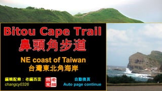
- 1. 編輯配樂:老編西歪 自動換頁 changcy0326 Auto page continue
- 2. From afar, Bitou Cape looks like the nose of a kitten leaning by the sea. 從遠處看起來,鼻頭角像似小貓的鼻子傾向著大海。
- 4. Bitou Cape Trail 鼻頭角步道 From afar, Bitou Cape looks like the nose of a kitten leaning by the sea. The total area of the cape is about 4 to 5 km2, whose tall abrasion caves, platforms and other eroded landforms are clearly in sight on the cape's hanging cliff. With an elevation of about 120m, the famous Bitou Cape Lighthouse is at the end of the trail along which one can enjoy the endless ocean scenes and the eroded landforms. Standing in the lighthouse, waves from the East China Sea and the Pacific are meeting and flapping right in front of you. 從遠處看起來,鼻頭角像似小貓的鼻子傾向著大海。鼻頭角的總面積大約 4到 5 平方公里,在海角懸垂的峭壁處,可以清楚地看到耐磨性的蝕穴,平臺,和其他 侵蝕地貌。海拔大約 120m,沿著享用不盡的海洋風光和侵蝕地貌,著名鼻頭角 燈塔就在步道的末端。站在燈塔附近,海浪從東海和太平洋會合,拍打在你的面 前。
- 5. Bitou fishery port and coastal highway parking lot 鼻頭漁港及濱海公路旁停車場 parking lot Bitou fishery port 停車場 鼻頭漁港
- 6. Bitou Cape Trail entrance 鼻頭角步道入口
- 7. Bitou Cape Trail designed in three parts 鼻頭角步道分為三個段落 1. Lighthouse Trail is main trail on hillside, from Bitou elementary school to Bitou cape lighthouse. 「燈塔步道」為主步道,走於山腰,起自鼻頭國小,終點至鼻頭岬角最突出的鼻 頭角燈塔; 2. Valley Trail cross though the headland on the edge of the Hill, overlooking the northeast corner of the coast; 「稜谷步道」則翻越岬角上的山稜,可眺望東北角海岸; 3. Coastal Trail close to the waterfront, will be able to enjoy more surprising changes in the sea geological landscape. 「海濱步道」貼近海岸,可欣賞變化多奇的海蝕地質景觀。
- 12. Bitou Elementary School 鼻頭國小
- 13. Bitou Elementary School 鼻頭國小
- 21. Coastal Trails 海濱步道 ‧Wave-cut platforms landscape 海蝕平台景觀 ‧Fishermen braved the wind and waves struck holding the pole fishing 釣客冒著風浪吹襲持竿海釣
- 26. Moon-Looking Hillside 望月坡
- 27. Valley Trail 稜谷步道 Lighthouse Trail 鼻頭角燈塔步道 Coastal Trails 海濱步道
- 28. Lighthouse Trail 鼻頭角燈塔步道 Due to landslides, Bitou Cape Lighthouse trails was temporarily closed today. 由於道路坍方鼻頭角燈塔步道今天暫時封閉
- 39. Valley Trail and Scenic Point 稜谷步道及觀景亭
- 48. Seafood Restaurant 海鮮餐廳 鳥瞰鼻頭漁港
- 55. Bitou fishery port 鼻頭漁港
- 59. Music : Morning Has Broken (夢迴晨曦) http://www.slideshare.net/changcy0326