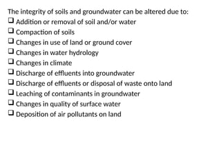
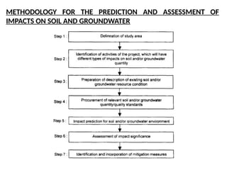
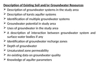
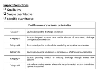
PREDICTION AND ASSESSMENT
OF IMPACTS
K. PAVAN KUMAR
Associate Professor
SCALE VIT University
Prediction and Assessment of
Impacts on Soil and Groundwater
Environment
The integrity of soils and groundwater can be altered due to:
 Addition or removal of soil and/or water
 Compaction of soils
 Changes in use of land or ground cover
 Changes in water hydrology
 Changes in climate
 Discharge of effluents into groundwater
 Discharge of effluents or disposal of waste onto land
 Leaching of contaminants in groundwater
 Changes in quality of surface water
 Deposition of air pollutants on land
METHODOLOGY FOR THE PREDICTION AND ASSESSMENT OF
IMPACTS ON SOIL AND GROUNDWATER
Delineation of Study Area
 The proposed or future land-use map along with committed land-
use policies, zoning, and development projects should be included
in the study area.
 The map should clearly distinguish between developed and
undeveloped land. Categories shown on land-use map, should be
- Residential
- Commercial and industrial
- Institutional and parks or recreation
- Non-urban mixed
 The map could include further divisions, such as separate
commercial and industrial activity centres and public vacant lands
Identification of Impacts
 Landforms
 Soil profile
 Soil composition
 Slope stability
 Seismicity
 Subsidence and compaction
 Flood plains and swamps
 Land use
 Mineral or engineering resources
 Buffer zones
Example of projects causing direct revision of land use:
(a) A highway project with a 300 m right-of-way width converts
whatever the existing land use is to a transportation land- use within
that right-of-way width.
(b) A dam constructed to create a reservoir for water supply and
recreational use directly converts the previous land use to
recreational use.
(c) A regional park constructed on land previously used as pasture
directly changes the number of acres of the park into a different use.
(d) A city block of low-income housing structures is demolished to
construct a shopping mall, directly converting that land to
commercial use.
Examination of Existing and Future Planned Land Use for Delineating
Study Area
 An initial activity is co-ordination with the regional planning
organization and with the local planning officials and zoning
agencies. This early contact is valuable to:
 Determine the existing and planned land- use and zoning for the
area of the proposed project,
 Identify any particular problem,
 Identify goals for land- use and economic development
 Initiate continued review and co-ordination throughout the project
study phase.
Environmental Impacts on Soil and Groundwater – A Typical
Example: Road Construction Project
 Impacts and setting
 Loss or productive soil
 Erosion
 Destabilization of slopes
 Side tipping of spoil materials
 Water flow diversions
 Engineering measures
Preliminary Analysis for General Projects
1. Soil Impacts
• The degradation of soil fertility due to increase in concentration of sodium,
caused by water logging and application of chemical fertilizers
• Physical loss of soil through accelerated erosion due to the action of water and
wind
• Impact of the conversion of good farm lands into reservoirs and dwelling areas
Groundwater Quantity and Quality Impacts
1. Land subsidence – due to over-pumping of groundwater
2. Impacts associated with identification and usage of construction
materials
3. Increased soil erosion in construction area
4. Landslides caused by inappropriate slope stabilities
5. Constructing and operating nuclear power plants
6. Strip-mining operations for coal extractions
7. Projects may create acid rains in localized areas
8. Projects that involve development along coastal regions
9. Construction and operation of surface water reservoir projects
10. Projects associated with agriculture uses
Description of Existing Soil and/or Groundwater Resources
 Description of groundwater systems in the study area
 Description of karsts aquifer systems
 Identification of multiple groundwater systems
 Groundwater potential in study area
 Uses of groundwater in the study area
 A description of interaction between groundwater system and
surface water bodies if any
 Identification of groundwater recharge zones
 Depth of groundwater
 Unsaturated zone permeability
 An existing data on groundwater quality
 Knowledge of aquifer parameters
Impact Predictions
 Qualitative
 Simple quantitative
 Specific quantitative
Possible sources of groundwater contamination
Category I Sources designed to discharge substances
Category II Sources designed to store treat and/or dispose of substances; discharge
through unplanned release
Category III Sources designed to retain substances during transport or transmission
Category IV Sources discharging substances as consequence of other planned activities
Category V
Sources providing conduit or inducing discharge through altered flow
patterns
Category VI
Naturally occurring sources whose discharge is created and/or exacerbated
by human activities

Baseline data collection for Impact Assessment.pptx

  • 1.
    PREDICTION AND ASSESSMENT OFIMPACTS K. PAVAN KUMAR Associate Professor SCALE VIT University
  • 2.
    Prediction and Assessmentof Impacts on Soil and Groundwater Environment
  • 3.
    The integrity ofsoils and groundwater can be altered due to:  Addition or removal of soil and/or water  Compaction of soils  Changes in use of land or ground cover  Changes in water hydrology  Changes in climate  Discharge of effluents into groundwater  Discharge of effluents or disposal of waste onto land  Leaching of contaminants in groundwater  Changes in quality of surface water  Deposition of air pollutants on land
  • 4.
    METHODOLOGY FOR THEPREDICTION AND ASSESSMENT OF IMPACTS ON SOIL AND GROUNDWATER
  • 5.
    Delineation of StudyArea  The proposed or future land-use map along with committed land- use policies, zoning, and development projects should be included in the study area.  The map should clearly distinguish between developed and undeveloped land. Categories shown on land-use map, should be - Residential - Commercial and industrial - Institutional and parks or recreation - Non-urban mixed  The map could include further divisions, such as separate commercial and industrial activity centres and public vacant lands
  • 6.
    Identification of Impacts Landforms  Soil profile  Soil composition  Slope stability  Seismicity  Subsidence and compaction  Flood plains and swamps  Land use  Mineral or engineering resources  Buffer zones
  • 7.
    Example of projectscausing direct revision of land use: (a) A highway project with a 300 m right-of-way width converts whatever the existing land use is to a transportation land- use within that right-of-way width. (b) A dam constructed to create a reservoir for water supply and recreational use directly converts the previous land use to recreational use. (c) A regional park constructed on land previously used as pasture directly changes the number of acres of the park into a different use. (d) A city block of low-income housing structures is demolished to construct a shopping mall, directly converting that land to commercial use.
  • 8.
    Examination of Existingand Future Planned Land Use for Delineating Study Area  An initial activity is co-ordination with the regional planning organization and with the local planning officials and zoning agencies. This early contact is valuable to:  Determine the existing and planned land- use and zoning for the area of the proposed project,  Identify any particular problem,  Identify goals for land- use and economic development  Initiate continued review and co-ordination throughout the project study phase.
  • 9.
    Environmental Impacts onSoil and Groundwater – A Typical Example: Road Construction Project  Impacts and setting  Loss or productive soil  Erosion  Destabilization of slopes  Side tipping of spoil materials  Water flow diversions  Engineering measures
  • 10.
    Preliminary Analysis forGeneral Projects 1. Soil Impacts • The degradation of soil fertility due to increase in concentration of sodium, caused by water logging and application of chemical fertilizers • Physical loss of soil through accelerated erosion due to the action of water and wind • Impact of the conversion of good farm lands into reservoirs and dwelling areas
  • 12.
    Groundwater Quantity andQuality Impacts 1. Land subsidence – due to over-pumping of groundwater 2. Impacts associated with identification and usage of construction materials 3. Increased soil erosion in construction area 4. Landslides caused by inappropriate slope stabilities 5. Constructing and operating nuclear power plants 6. Strip-mining operations for coal extractions 7. Projects may create acid rains in localized areas 8. Projects that involve development along coastal regions 9. Construction and operation of surface water reservoir projects 10. Projects associated with agriculture uses
  • 13.
    Description of ExistingSoil and/or Groundwater Resources  Description of groundwater systems in the study area  Description of karsts aquifer systems  Identification of multiple groundwater systems  Groundwater potential in study area  Uses of groundwater in the study area  A description of interaction between groundwater system and surface water bodies if any  Identification of groundwater recharge zones  Depth of groundwater  Unsaturated zone permeability  An existing data on groundwater quality  Knowledge of aquifer parameters
  • 14.
    Impact Predictions  Qualitative Simple quantitative  Specific quantitative Possible sources of groundwater contamination Category I Sources designed to discharge substances Category II Sources designed to store treat and/or dispose of substances; discharge through unplanned release Category III Sources designed to retain substances during transport or transmission Category IV Sources discharging substances as consequence of other planned activities Category V Sources providing conduit or inducing discharge through altered flow patterns Category VI Naturally occurring sources whose discharge is created and/or exacerbated by human activities