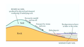
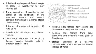
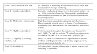
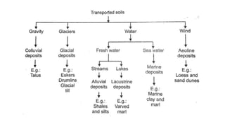
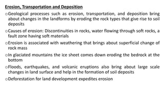
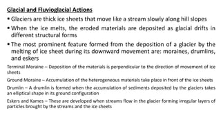
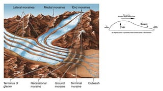
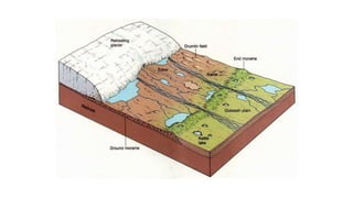
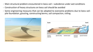
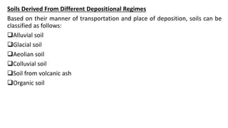
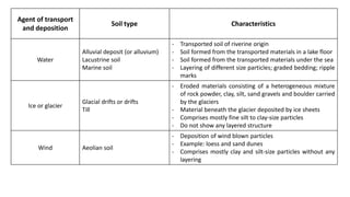
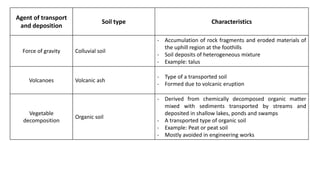
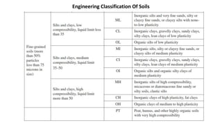
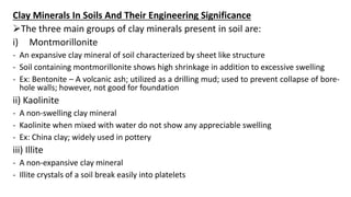
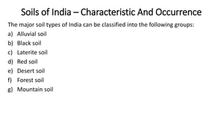
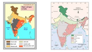
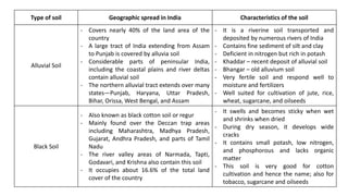
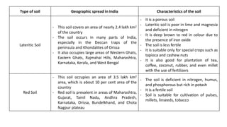
Properties of Soils
Dr. K. Pavan Kumar
Associate Professor
Department of Civil Engineering
Vasavi College of Engineering, Hyderabad
Learning Objectives
Role of geological processes in changing land forms
Geological works of ice and wind
Formation of different types of soils and their engineering uses
Components, structures and descriptive analysis of soils
Classification of soils as per Indian specifications
Indian soils including their origins and places of occurrence
Clay minerals and their effects on the soils
Geological Processes Responsible For Soil Formation
 Processes such as erosion, transportation, and deposition of soil have been
actively associated with changing lands of the earth’s surface since a long
geological time
 Water, wind and ice are the main agents associated with the processes that
produce soils and cause their transportation
 An understanding of these processes that control the land patterns is
necessary to examine the merits and demerits of a site while carrying out an
engineering geological investigation
1. Formation of Soils From Weathering and Decomposition of Rocks
Weathering of rocks of the uppermost crust of the earth is a complex
process of disintegration and decomposition of rock body
Disintegration – Mechanical Weathering
Decomposition – Chemical Weathering
Decomposition of rocks – soils with clay minerals
Expansive soil consisting of swelling type of clay minerals is harmful if
present in the foundation
2. Residual And Transported Soils
Soil covering only the top part of the bedrock from which it has been derived
is known as residual soil
A deposit of residual soil remains in same position capping the parent rock
since its origin
 A bedrock undergoes different stages
or grades of weathering to form
residual soil
 These gradations of weathering are
based on the conditions of the
structure, texture, and mineral
contents from initial to advance stages
of weathering
 Thickness of residual soil deposits – 15
m to 60 m
 Prevalent in hill slopes and plateau
regions
 Occurrence: Black soil mantle of the
Deccan basalts; lateritic soils in
different parts of India
 Residual soils formed from granite and
charnokite – better for foundation
 Residual soils formed from shale,
sandstone and limestone – not good for
foundation
 Storage structure or a reservoir
constructed in such a terrain may lead to
leakage of water
 Transported Soil – Soil formed of materials transported and deposited away
from its original place of formation
 The deposit of a transported soil may be very thick (varying between 100 m to
5000 m)
 Example: Alluvial soil covering the Indo-Gangetic plains
 Transported soil does not retain the ingredients of the parent rock
 Transported soil is a mixture of particles derived from rocks of two or more
regions
 Depending on the manner of transportation and condition of deposition can
be homogeneous or heterogeneous
 Frequently contain lenses or layers of organic matter
Erosion, Transportation and Deposition
oGeological processes such as erosion, transportation, and deposition bring
about changes in the landforms by eroding the rock types that give rise to soil
deposits
oCauses of erosion: Discontinuities in rocks, water flowing through soft rocks, a
fault zone having soft materials
oErosion is associated with weathering that brings about superficial change of
rock mass
oIn glaciated mountains the ice sheet comes down eroding the bedrock at the
bottom
oFloods, earthquakes, and volcanic eruptions also bring about large scale
changes in land surface and help in the formation of soil deposits
oDeforestation for land development expedites erosion
Glacial and Fluvioglacial Actions
 Glaciers are thick ice sheets that move like a stream slowly along hill slopes
 When the ice melts, the eroded materials are deposited as glacial drifts in
different structural forms
 The most prominent feature formed from the deposition of a glacier by the
melting of ice sheet during its downward movement are: moraines, drumlins,
and eskers
Terminal Moraine – Deposition of the materials is perpendicular to the direction of movement of ice
sheets
Ground Moraine – Accumulation of the heterogeneous materials take place in front of the ice sheets
Drumlin – A drumlin is formed when the accumulation of sediments deposited by the glaciers takes
an elliptical shape in its ground configuration
Eskers and Kames – These are developed when streams flow in the glacier forming irregular layers of
particles brought by the streams and the ice sheets
 All the aforementioned glacial structures vary in thickness between 15 m to 60 m and
stretch in length for a few hundred meters to thousands of meters
 In India, glacial deposits can be seen in Himalayan regions
Engineering Problems With Glacial Deposits
• Can encounter problems of permeability and stability
• A foundation of a dam on this type of deposits will lead to differential settlements
• A reservoir may experience leakage
• Construction of highways in such places may encounter frequent slope failures
Data Required For Feasibility Stage Investigation
o Stability and permeability of glacial drift
o Information pertaining to snow line
o Rate of movement of ice sheets
o Volume of load depositing in the downstream parts by melting ice sheets
o Chance of avalanche striking the proposed structure
Wind Action and Windborne Deposits
Wind is an important force causing erosion
Power of a wind to erode depends on:
- Particle size
- Wind strength
- Whether the particles are able to be picked up by the wind
More prevalent in arid regions than humid regions
Different types of windborne deposits are:
Sand dunes
- Created due to wind blown loose sands from plains
- The dunes may form geometric pattern of structures such as crescent or ridge-shaped
Barchans or irregular sand deposits
- May vary in height between a few metres to about 100 metres
- Dunes are characterized by their mobility from one place to another place caused by the
sweeping of the sand due to high winds
- The sands blown from Arabian Sea Coast were deposited in parts of Rajasthan giving rise
to a desert-like land forms with sand dunes
- Stability problems may be encountered in the construction of roads and highways
- Road maintenance can be difficult
- Canals constructed through the areas of sand dunes need to be lined due to the porous
nature of the deposits
Loess
- Loess is a aeolian (windborne) deposit
- Such a soil is porous and permeable in nature, and is constituted of poorly graded fine
sand, silt and clay
- Loess soil consolidates when it comes in contact with water
- Permeability is greater in horizontal direction as compared to vertical direction
- Loess can withstand very steep slope cuts at places even up to vertical angles
- Main structural problem encountered in loess soil – subsidence under wet conditions
- Construction of heavy structures on loess soil should be avoided
- Some engineering measures that can be adopted to overcome problems due to loess soil:
pile foundation, grouting, constructing berms, soil compaction, rolling
Soils Derived From Different Depositional Regimes
Based on their manner of transportation and place of deposition, soils can be
classified as follows:
Alluvial soil
Glacial soil
Aeolian soil
Colluvial soil
Soil from volcanic ash
Organic soil
Agent of transport
and deposition
Soil type Characteristics
Water
Alluvial deposit (or alluvium)
Lacustrine soil
Marine soil
- Transported soil of riverine origin
- Soil formed from the transported materials in a lake floor
- Soil formed from the transported materials under the sea
- Layering of different size particles; graded bedding; ripple
marks
Ice or glacier
Glacial drifts or drifts
Till
- Eroded materials consisting of a heterogeneous mixture
of rock powder, clay, silt, sand gravels and boulder carried
by the glaciers
- Material beneath the glacier deposited by ice sheets
- Comprises mostly fine silt to clay-size particles
- Do not show any layered structure
Wind Aeolian soil
- Deposition of wind blown particles
- Example: loess and sand dunes
- Comprises mostly clay and silt-size particles without any
layering
Agent of transport
and deposition
Soil type Characteristics
Force of gravity Colluvial soil
- Accumulation of rock fragments and eroded materials of
the uphill region at the foothills
- Soil deposits of heterogeneous mixture
- Example: talus
Volcanoes Volcanic ash
- Type of a transported soil
- Formed due to volcanic eruption
Vegetable
decomposition
Organic soil
- Derived from chemically decomposed organic matter
mixed with sediments transported by streams and
deposited in shallow lakes, ponds and swamps
- A transported type of organic soil
- Example: Peat or peat soil
- Mostly avoided in engineering works
Soil Classification For Engineering Constructions
 Soil classification is aimed at describing the various types of soil in a
systematic way and at dividing soils of distinct physical properties into groups
or units
 Unified Soils Classification System (USCS) – Arthur Casagrande (1943)
 Indian Standard (IS) classification of soils is based on USCS
 USCS classification is based on: size of soil particles; texture of the constituent
grains; organic content; plasticity; grading; compressibility
 Soils are grouped into three divisions:
- Coarse grained
- Fine grained
- Organic soil
Coarse Grained Soils
o More than 50% material by weight will be retained above the 75-micron sieve
o Basic components of soils of this division are: boulders, cobbles, gravels, and sand
o IS Classification:
W – Well-graded and clean
C – Well-graded with good clay binding
P – Poorly graded but fairly clean
M – Poorly graded mixed with finer materials
GW, GC, GP, GM – For gravels
SW, SC, SP, SM – For sand
Fine Grained Soils
o More than 50% of the particles by weight are silt and clay that pass through the 75-micron
sieve
o Size of silt particles is 75 microns to 2 microns; and that of clay is < 2 microns
o The fine grained soils are grouped under three sub-divisions: mixed silt and fine sands of
inorganic nature; clay of inorganic type; organic matter with silty and clayey particles
o IS classification of fine grained soils:
ML – Silt of low plasticity
MI – Silt of intermediate or medium plasticity
MH – Silt of high plasticity
CL – Clay of low plasticity
CI – Clay of intermediate or medium plasticity
CH – Clay of high plasticity
Organic Soils
o Contain organic matter including peat (PT) and decomposed vegetable products in large
quantities
o These soils have high compressibility
o The symbols, OL, OI, and OH denote organic soil of low, medium and high plasticity
respectively
Engineering Classification Of Soils
Visual Observation To Identify Soil Types
 Coarse grained soil is identified in a hand specimen with respect to its grain
size, shape, grading and mineral contents
 Identification of fine grained soil is done by estimating its plasticity, dilatancy,
and toughness
 Plasticity can be determined by rolling a small quantity of soil on the palm to
make threads of approximately 3 mm diameter.
- If the thread remains intact the soil is of high plasticity
- If cracks develop it suggests a low plasticity
 Dilatancy is estimated by holding about 1 cm3 soil sample on the palm of one
hand and shaking it with the help of other hand
- If moisture beads are formed quickly on the surface, the soil type is inorganic fine sands,
clayey fine sands, or clayey silts which are non-plastic in nature
- However, when the formation of the moisture bead is slow, the soil type is inorganic,
organic silty, or clayey with medium to low plasticity
- No bead of water is formed in soils type such as inorganic clay, or silt clay with medium to
high plasticity
 Toughness of the clay is roughly estimated by taking a small quantity of wet
soil and using hand pressure
- Soil with substantial clay, good plasticity, and low dilatancy possesses high
toughness
- Fine sandy and silty soil with no plasticity but showing quick dilatancy has no
toughness
Clay Minerals In Soils And Their Engineering Significance
The three main groups of clay minerals present in soil are:
i) Montmorillonite
- An expansive clay mineral of soil characterized by sheet like structure
- Soil containing montmorillonite shows high shrinkage in addition to excessive swelling
- Ex: Bentonite – A volcanic ash; utilized as a drilling mud; used to prevent collapse of bore-
hole walls; however, not good for foundation
ii) Kaolinite
- A non-swelling clay mineral
- Kaolinite when mixed with water do not show any appreciable swelling
- Ex: China clay; widely used in pottery
iii) Illite
- A non-expansive clay mineral
- Illite crystals of a soil break easily into platelets
Soils of India – Characteristic And Occurrence
The major soil types of India can be classified into the following groups:
a) Alluvial soil
b) Black soil
c) Laterite soil
d) Red soil
e) Desert soil
f) Forest soil
g) Mountain soil
Type of soil Geographic spread in India Characteristics of the soil
Alluvial Soil
- Covers nearly 40% of the land area of the
country
- A large tract of India extending from Assam
to Punjab is covered by alluvia soil
- Considerable parts of peninsular India,
including the coastal plains and river deltas
contain alluvial soil
- The northern alluvial tract extends over many
states—Punjab, Haryana, Uttar Pradesh,
Bihar, Orissa, West Bengal, and Assam
- It is a riverine soil transported and
deposited by numerous rivers of India
- Contains fine sediment of silt and clay
- Deficient in nitrogen but rich in potash
- Khaddar – recent deposit of alluvial soil
- Bhangar – old alluvium soil
- Very fertile soil and respond well to
moisture and fertilizers
- Well suited for cultivation of jute, rice,
wheat, sugarcane, and oilseeds
Black Soil
- Also known as black cotton soil or regur
- Mainly found over the Deccan trap areas
including Maharashtra, Madhya Pradesh,
Gujarat, Andhra Pradesh, and parts of Tamil
Nadu
- The river valley areas of Narmada, Tapti,
Godavari, and Krishna also contain this soil
- It occupies about 16.6% of the total land
cover of the country
- It swells and becomes sticky when wet
and shrinks when dried
- During dry season, it develops wide
cracks
- It contains small potash, low nitrogen,
and phosphorous and lacks organic
matter
- This soil is very good for cotton
cultivation and hence the name; also for
tobacco, sugarcane and oilseeds
Type of soil Geographic spread in India Characteristics of the soil
Lateritic Soil
- This soil covers an area of nearly 2.4 lakh km2
of the country
- The soil occurs in many parts of India,
especially in the Deccan traps of the
peninsula and Khondalites of Orissa
- It also occupies large areas of Western Ghats,
Eastern Ghats, Rajmahal Hills, Maharashtra,
Karnataka, Kerala, and West Bengal
- It is a porous soil
- Lateritic soil is poor in lime and magnesia
and deficient in nitrogen
- It is deep brown to red in colour due to
the presence of iron oxide
- The soil is less fertile
- It is suitable only for special crops such as
tapioca and cashew nuts
- It is also good for plantation of tea,
coffee, coconut, rubber, and even millet
with the use of fertilizers
Red Soil
- This soil occupies an area of 3.5 lakh km2
area, which is about 10 per cent area of the
country
- Red soil is prevalent in areas of Maharashtra,
Gujarat, Tamil Nadu, Andhra Pradesh,
Karnataka, Orissa, Bundelkhand, and Chota
Nagpur plateau
- The soil is deficient in nitrogen, humus,
and phosphorous but rich in potash
- It is a fertile soil
- Soil is suitable for cultivation of pulses,
millets, linseeds, tobacco

Properties of Soils.pptx

  • 1.
    Properties of Soils Dr.K. Pavan Kumar Associate Professor Department of Civil Engineering Vasavi College of Engineering, Hyderabad
  • 2.
    Learning Objectives Role ofgeological processes in changing land forms Geological works of ice and wind Formation of different types of soils and their engineering uses Components, structures and descriptive analysis of soils Classification of soils as per Indian specifications Indian soils including their origins and places of occurrence Clay minerals and their effects on the soils
  • 3.
    Geological Processes ResponsibleFor Soil Formation  Processes such as erosion, transportation, and deposition of soil have been actively associated with changing lands of the earth’s surface since a long geological time  Water, wind and ice are the main agents associated with the processes that produce soils and cause their transportation  An understanding of these processes that control the land patterns is necessary to examine the merits and demerits of a site while carrying out an engineering geological investigation
  • 5.
    1. Formation ofSoils From Weathering and Decomposition of Rocks Weathering of rocks of the uppermost crust of the earth is a complex process of disintegration and decomposition of rock body Disintegration – Mechanical Weathering Decomposition – Chemical Weathering Decomposition of rocks – soils with clay minerals Expansive soil consisting of swelling type of clay minerals is harmful if present in the foundation 2. Residual And Transported Soils Soil covering only the top part of the bedrock from which it has been derived is known as residual soil A deposit of residual soil remains in same position capping the parent rock since its origin
  • 6.
     A bedrockundergoes different stages or grades of weathering to form residual soil  These gradations of weathering are based on the conditions of the structure, texture, and mineral contents from initial to advance stages of weathering  Thickness of residual soil deposits – 15 m to 60 m  Prevalent in hill slopes and plateau regions  Occurrence: Black soil mantle of the Deccan basalts; lateritic soils in different parts of India  Residual soils formed from granite and charnokite – better for foundation  Residual soils formed from shale, sandstone and limestone – not good for foundation  Storage structure or a reservoir constructed in such a terrain may lead to leakage of water
  • 8.
     Transported Soil– Soil formed of materials transported and deposited away from its original place of formation  The deposit of a transported soil may be very thick (varying between 100 m to 5000 m)  Example: Alluvial soil covering the Indo-Gangetic plains  Transported soil does not retain the ingredients of the parent rock  Transported soil is a mixture of particles derived from rocks of two or more regions  Depending on the manner of transportation and condition of deposition can be homogeneous or heterogeneous  Frequently contain lenses or layers of organic matter
  • 10.
    Erosion, Transportation andDeposition oGeological processes such as erosion, transportation, and deposition bring about changes in the landforms by eroding the rock types that give rise to soil deposits oCauses of erosion: Discontinuities in rocks, water flowing through soft rocks, a fault zone having soft materials oErosion is associated with weathering that brings about superficial change of rock mass oIn glaciated mountains the ice sheet comes down eroding the bedrock at the bottom oFloods, earthquakes, and volcanic eruptions also bring about large scale changes in land surface and help in the formation of soil deposits oDeforestation for land development expedites erosion
  • 11.
    Glacial and FluvioglacialActions  Glaciers are thick ice sheets that move like a stream slowly along hill slopes  When the ice melts, the eroded materials are deposited as glacial drifts in different structural forms  The most prominent feature formed from the deposition of a glacier by the melting of ice sheet during its downward movement are: moraines, drumlins, and eskers Terminal Moraine – Deposition of the materials is perpendicular to the direction of movement of ice sheets Ground Moraine – Accumulation of the heterogeneous materials take place in front of the ice sheets Drumlin – A drumlin is formed when the accumulation of sediments deposited by the glaciers takes an elliptical shape in its ground configuration Eskers and Kames – These are developed when streams flow in the glacier forming irregular layers of particles brought by the streams and the ice sheets
  • 14.
     All theaforementioned glacial structures vary in thickness between 15 m to 60 m and stretch in length for a few hundred meters to thousands of meters  In India, glacial deposits can be seen in Himalayan regions Engineering Problems With Glacial Deposits • Can encounter problems of permeability and stability • A foundation of a dam on this type of deposits will lead to differential settlements • A reservoir may experience leakage • Construction of highways in such places may encounter frequent slope failures Data Required For Feasibility Stage Investigation o Stability and permeability of glacial drift o Information pertaining to snow line o Rate of movement of ice sheets o Volume of load depositing in the downstream parts by melting ice sheets o Chance of avalanche striking the proposed structure
  • 15.
    Wind Action andWindborne Deposits Wind is an important force causing erosion Power of a wind to erode depends on: - Particle size - Wind strength - Whether the particles are able to be picked up by the wind More prevalent in arid regions than humid regions Different types of windborne deposits are: Sand dunes - Created due to wind blown loose sands from plains - The dunes may form geometric pattern of structures such as crescent or ridge-shaped Barchans or irregular sand deposits - May vary in height between a few metres to about 100 metres
  • 16.
    - Dunes arecharacterized by their mobility from one place to another place caused by the sweeping of the sand due to high winds - The sands blown from Arabian Sea Coast were deposited in parts of Rajasthan giving rise to a desert-like land forms with sand dunes - Stability problems may be encountered in the construction of roads and highways - Road maintenance can be difficult - Canals constructed through the areas of sand dunes need to be lined due to the porous nature of the deposits Loess - Loess is a aeolian (windborne) deposit - Such a soil is porous and permeable in nature, and is constituted of poorly graded fine sand, silt and clay - Loess soil consolidates when it comes in contact with water - Permeability is greater in horizontal direction as compared to vertical direction - Loess can withstand very steep slope cuts at places even up to vertical angles
  • 17.
    - Main structuralproblem encountered in loess soil – subsidence under wet conditions - Construction of heavy structures on loess soil should be avoided - Some engineering measures that can be adopted to overcome problems due to loess soil: pile foundation, grouting, constructing berms, soil compaction, rolling
  • 18.
    Soils Derived FromDifferent Depositional Regimes Based on their manner of transportation and place of deposition, soils can be classified as follows: Alluvial soil Glacial soil Aeolian soil Colluvial soil Soil from volcanic ash Organic soil
  • 19.
    Agent of transport anddeposition Soil type Characteristics Water Alluvial deposit (or alluvium) Lacustrine soil Marine soil - Transported soil of riverine origin - Soil formed from the transported materials in a lake floor - Soil formed from the transported materials under the sea - Layering of different size particles; graded bedding; ripple marks Ice or glacier Glacial drifts or drifts Till - Eroded materials consisting of a heterogeneous mixture of rock powder, clay, silt, sand gravels and boulder carried by the glaciers - Material beneath the glacier deposited by ice sheets - Comprises mostly fine silt to clay-size particles - Do not show any layered structure Wind Aeolian soil - Deposition of wind blown particles - Example: loess and sand dunes - Comprises mostly clay and silt-size particles without any layering
  • 20.
    Agent of transport anddeposition Soil type Characteristics Force of gravity Colluvial soil - Accumulation of rock fragments and eroded materials of the uphill region at the foothills - Soil deposits of heterogeneous mixture - Example: talus Volcanoes Volcanic ash - Type of a transported soil - Formed due to volcanic eruption Vegetable decomposition Organic soil - Derived from chemically decomposed organic matter mixed with sediments transported by streams and deposited in shallow lakes, ponds and swamps - A transported type of organic soil - Example: Peat or peat soil - Mostly avoided in engineering works
  • 21.
    Soil Classification ForEngineering Constructions  Soil classification is aimed at describing the various types of soil in a systematic way and at dividing soils of distinct physical properties into groups or units  Unified Soils Classification System (USCS) – Arthur Casagrande (1943)  Indian Standard (IS) classification of soils is based on USCS  USCS classification is based on: size of soil particles; texture of the constituent grains; organic content; plasticity; grading; compressibility  Soils are grouped into three divisions: - Coarse grained - Fine grained - Organic soil
  • 22.
    Coarse Grained Soils oMore than 50% material by weight will be retained above the 75-micron sieve o Basic components of soils of this division are: boulders, cobbles, gravels, and sand o IS Classification: W – Well-graded and clean C – Well-graded with good clay binding P – Poorly graded but fairly clean M – Poorly graded mixed with finer materials GW, GC, GP, GM – For gravels SW, SC, SP, SM – For sand Fine Grained Soils o More than 50% of the particles by weight are silt and clay that pass through the 75-micron sieve o Size of silt particles is 75 microns to 2 microns; and that of clay is < 2 microns
  • 23.
    o The finegrained soils are grouped under three sub-divisions: mixed silt and fine sands of inorganic nature; clay of inorganic type; organic matter with silty and clayey particles o IS classification of fine grained soils: ML – Silt of low plasticity MI – Silt of intermediate or medium plasticity MH – Silt of high plasticity CL – Clay of low plasticity CI – Clay of intermediate or medium plasticity CH – Clay of high plasticity Organic Soils o Contain organic matter including peat (PT) and decomposed vegetable products in large quantities o These soils have high compressibility o The symbols, OL, OI, and OH denote organic soil of low, medium and high plasticity respectively
  • 24.
  • 25.
  • 26.
    Visual Observation ToIdentify Soil Types  Coarse grained soil is identified in a hand specimen with respect to its grain size, shape, grading and mineral contents
  • 27.
     Identification offine grained soil is done by estimating its plasticity, dilatancy, and toughness  Plasticity can be determined by rolling a small quantity of soil on the palm to make threads of approximately 3 mm diameter. - If the thread remains intact the soil is of high plasticity - If cracks develop it suggests a low plasticity  Dilatancy is estimated by holding about 1 cm3 soil sample on the palm of one hand and shaking it with the help of other hand - If moisture beads are formed quickly on the surface, the soil type is inorganic fine sands, clayey fine sands, or clayey silts which are non-plastic in nature - However, when the formation of the moisture bead is slow, the soil type is inorganic, organic silty, or clayey with medium to low plasticity - No bead of water is formed in soils type such as inorganic clay, or silt clay with medium to high plasticity
  • 28.
     Toughness ofthe clay is roughly estimated by taking a small quantity of wet soil and using hand pressure - Soil with substantial clay, good plasticity, and low dilatancy possesses high toughness - Fine sandy and silty soil with no plasticity but showing quick dilatancy has no toughness
  • 29.
    Clay Minerals InSoils And Their Engineering Significance The three main groups of clay minerals present in soil are: i) Montmorillonite - An expansive clay mineral of soil characterized by sheet like structure - Soil containing montmorillonite shows high shrinkage in addition to excessive swelling - Ex: Bentonite – A volcanic ash; utilized as a drilling mud; used to prevent collapse of bore- hole walls; however, not good for foundation ii) Kaolinite - A non-swelling clay mineral - Kaolinite when mixed with water do not show any appreciable swelling - Ex: China clay; widely used in pottery iii) Illite - A non-expansive clay mineral - Illite crystals of a soil break easily into platelets
  • 30.
    Soils of India– Characteristic And Occurrence The major soil types of India can be classified into the following groups: a) Alluvial soil b) Black soil c) Laterite soil d) Red soil e) Desert soil f) Forest soil g) Mountain soil
  • 32.
    Type of soilGeographic spread in India Characteristics of the soil Alluvial Soil - Covers nearly 40% of the land area of the country - A large tract of India extending from Assam to Punjab is covered by alluvia soil - Considerable parts of peninsular India, including the coastal plains and river deltas contain alluvial soil - The northern alluvial tract extends over many states—Punjab, Haryana, Uttar Pradesh, Bihar, Orissa, West Bengal, and Assam - It is a riverine soil transported and deposited by numerous rivers of India - Contains fine sediment of silt and clay - Deficient in nitrogen but rich in potash - Khaddar – recent deposit of alluvial soil - Bhangar – old alluvium soil - Very fertile soil and respond well to moisture and fertilizers - Well suited for cultivation of jute, rice, wheat, sugarcane, and oilseeds Black Soil - Also known as black cotton soil or regur - Mainly found over the Deccan trap areas including Maharashtra, Madhya Pradesh, Gujarat, Andhra Pradesh, and parts of Tamil Nadu - The river valley areas of Narmada, Tapti, Godavari, and Krishna also contain this soil - It occupies about 16.6% of the total land cover of the country - It swells and becomes sticky when wet and shrinks when dried - During dry season, it develops wide cracks - It contains small potash, low nitrogen, and phosphorous and lacks organic matter - This soil is very good for cotton cultivation and hence the name; also for tobacco, sugarcane and oilseeds
  • 33.
    Type of soilGeographic spread in India Characteristics of the soil Lateritic Soil - This soil covers an area of nearly 2.4 lakh km2 of the country - The soil occurs in many parts of India, especially in the Deccan traps of the peninsula and Khondalites of Orissa - It also occupies large areas of Western Ghats, Eastern Ghats, Rajmahal Hills, Maharashtra, Karnataka, Kerala, and West Bengal - It is a porous soil - Lateritic soil is poor in lime and magnesia and deficient in nitrogen - It is deep brown to red in colour due to the presence of iron oxide - The soil is less fertile - It is suitable only for special crops such as tapioca and cashew nuts - It is also good for plantation of tea, coffee, coconut, rubber, and even millet with the use of fertilizers Red Soil - This soil occupies an area of 3.5 lakh km2 area, which is about 10 per cent area of the country - Red soil is prevalent in areas of Maharashtra, Gujarat, Tamil Nadu, Andhra Pradesh, Karnataka, Orissa, Bundelkhand, and Chota Nagpur plateau - The soil is deficient in nitrogen, humus, and phosphorous but rich in potash - It is a fertile soil - Soil is suitable for cultivation of pulses, millets, linseeds, tobacco