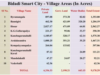
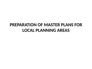
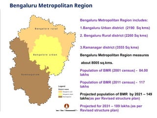
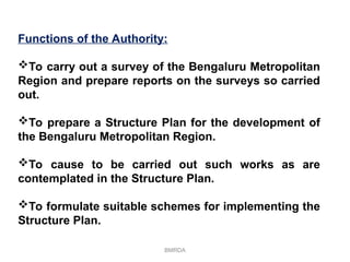
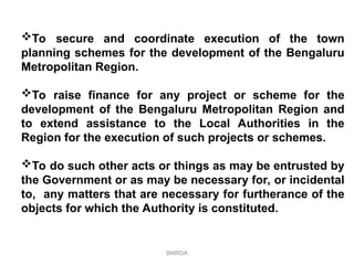
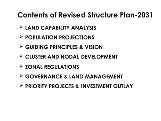
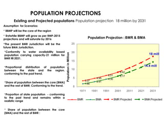
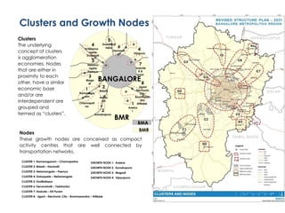
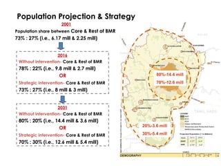
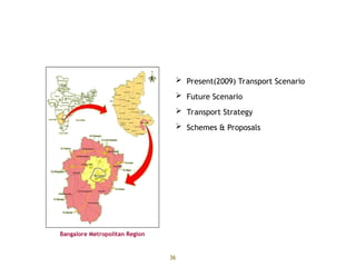
The Bengaluru Metropolitan Region Development Authority (BMRDA) was established on February 1, 1986, to oversee the planned development of the Bengaluru Metropolitan Region, which includes Bengaluru Urban, Bengaluru Rural, and Ramanagara districts, covering approximately 8005 sq.kms. The authority is responsible for creating structure plans, coordinating town planning schemes, and promoting sustainable development through spatial planning while addressing population growth projected to reach 18 million by 2031. The revised structure plan for 2031 aims to manage urbanization, enhance regional accessibility, and support decentralized governance while preserving ecological balance.

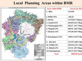


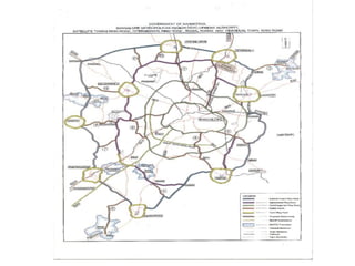


![Bidadi Integrated Township Location
From Bangalore
From Bangalore
City
City
35 Kms
35 Kms
From State
From State
Highway [B’lore-
Highway [B’lore-
Mysore Road]
Mysore Road]
3 Kms
3 Kms
From National
From National
Highway [NH-209]
Highway [NH-209]
15 Kms
15 Kms
Railway Station –
Railway Station –
[Bidadi Station on
[Bidadi Station on
the B’lore-Mysore
the B’lore-Mysore
Railway line]
Railway line]
9 Kms
9 Kms
New International
New International
Airport at
Airport at
Devanahalli
Devanahalli
45 Kms
45 Kms](https://image.slidesharecdn.com/bmrdauthority-240818070340-96297c51/85/bangalore-metropolitan-development-authority-72-320.jpg)
![3.Grater Bengaluru – Bidadi Smart City
• From Bangalore City -35 Kms
• From State Highway [B’lore-Mysore Road] -3 Kms
• From National Highway [NH-209] -15 Kms
• Railway Station – [Bidadi Station on the B’lore-Mysore
Railway line] -9 Kms
• New International Airport at Devanahalli – 65 kms](https://image.slidesharecdn.com/bmrdauthority-240818070340-96297c51/85/bangalore-metropolitan-development-authority-78-320.jpg)