Downloaded 130 times
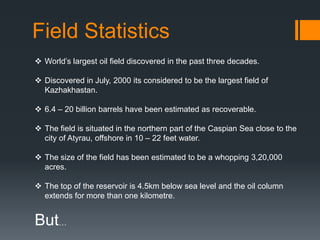


The Kashagan oil field is the largest oil field discovered in the last 30 years. Located in the northern Caspian Sea near Kazakhstan, it contains estimated reserves of 6.4-20 billion barrels of oil. However, production has not begun yet due to the huge costs involved, environmental concerns with drilling, and reluctance of the Kazakh government to involve foreign oil companies. The field's geology involves carbonate reservoir rocks formed from ancient coral reefs trapped beneath salt dome structures. Significant exploration and changes in ownership of the field have occurred over the years as its development challenges have continued.