Autonomous Navigation System
Architecture
Universidad Marítima del Caribe
Maritime Engineering
Maritime English
Compiled by César Rivas
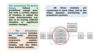
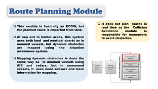
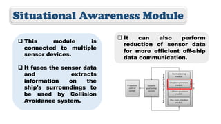
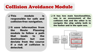
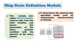
The autonomous
navigation system includes
the route planning
module, situational
awareness module,
collision avoidance
module, and the ship’s
state definition module.
All these modules are
connected to each other, and to the
ship’s dynamic positioning and
propulsion systems.
The Autonomous Navigation
System follows a
predefined voyage plan,
but with a certain degree
of freedom to adjust the
route autonomously, e.g.
due to an arising collision
situation or significant
weather changes.
Route Planning Module
 This module is basically an ECDIS, but
the planned route is imported from land.
 At sea and in harbor areas, this system
uses both land and nautical charts as in
manned vessels, but dynamic obstacles
are mapped using the situation
awareness system.
 Mapping dynamic obstacles is done the
same way as in manned vessels using
AIS and radars, but in unmanned
vessels, it uses more sensors and more
information for mapping.
 It does not plan routes in
real time as the Collision
Avoidance module is
responsible for maneuvers
to avoid obstacles.
Situational Awareness Module
 This module is
connected to multiple
sensor devices.
 It fuses the sensor data
and extracts
information on the
ship’s surroundings to
be used by Collision
Avoidance system.
 It can also perform
reduction of sensor data
for more efficient off-ship
data communication.
Collision Avoidance Module
 This module is
responsible for safe and
collision-free navigation.
 It uses information from
the Route Planning
module to follow a path
that leads to the
destination but can
deviate from the course
if a risk of collision is
detected.
 It has two main functionalities,
one is an assessment of the
collision risk and the other is to
navigate the ship safely both in
the harbor and in the open sea.
Ship State Definition Module
 This module, also
called Virtual Captain,
collects data from the
other modules, and
shares the
information of the
ship’s systems
condition with the
operator at the shore
station.
 It determines the allowed ship
operation mode, such as
autonomous, remote-control
or failsafe.
The ships’ dynamic positioning systems
purpose is to maintain ships adjusted position and
heading with help of GNSS devices, wind sensors,
propulsion systems e.g. Azipod-system, propellers
and rudder and bow/aft thrusters.
Datalink and communication are main components
of the autonomous navigation systems. When voyage
planning is done by the operator, s/he also has to
select the level of autonomy for the vessel. Meaning
that the operator can basically choose if the ship is
only remote-controlled or fully autonomous. Of course,
100% autonomous ships do not exist yet.
There is an area closed
to public ship traffic for
testing autonomous ships in
open waters.
It is an area of about 18
kilometers located near the
coast of Finland. It was
chosen by companies
because of good connectivity
and for autonomous ships to
be also tested in ice
conditions.
The name of this area
is Jaakonmeri test area.
For Your Information
References
Hyvonen, M.; Kolu, A. et all. (2016). Remote and Autonomous Ships. The Next Steps. AWAA project coordination. Online
Document. Retrieved from: https://www.rolls-royce.com/~/media/Files/R/Rolls-Royce/documents/customers/marine/ship-
intel/aawa-whitepaper-210616.pdf

Autonomous Navigation System Architecture

  • 1.
    Autonomous Navigation System Architecture UniversidadMarítima del Caribe Maritime Engineering Maritime English Compiled by César Rivas
  • 2.
    The autonomous navigation systemincludes the route planning module, situational awareness module, collision avoidance module, and the ship’s state definition module. All these modules are connected to each other, and to the ship’s dynamic positioning and propulsion systems. The Autonomous Navigation System follows a predefined voyage plan, but with a certain degree of freedom to adjust the route autonomously, e.g. due to an arising collision situation or significant weather changes.
  • 3.
    Route Planning Module This module is basically an ECDIS, but the planned route is imported from land.  At sea and in harbor areas, this system uses both land and nautical charts as in manned vessels, but dynamic obstacles are mapped using the situation awareness system.  Mapping dynamic obstacles is done the same way as in manned vessels using AIS and radars, but in unmanned vessels, it uses more sensors and more information for mapping.  It does not plan routes in real time as the Collision Avoidance module is responsible for maneuvers to avoid obstacles.
  • 4.
    Situational Awareness Module This module is connected to multiple sensor devices.  It fuses the sensor data and extracts information on the ship’s surroundings to be used by Collision Avoidance system.  It can also perform reduction of sensor data for more efficient off-ship data communication.
  • 5.
    Collision Avoidance Module This module is responsible for safe and collision-free navigation.  It uses information from the Route Planning module to follow a path that leads to the destination but can deviate from the course if a risk of collision is detected.  It has two main functionalities, one is an assessment of the collision risk and the other is to navigate the ship safely both in the harbor and in the open sea.
  • 6.
    Ship State DefinitionModule  This module, also called Virtual Captain, collects data from the other modules, and shares the information of the ship’s systems condition with the operator at the shore station.  It determines the allowed ship operation mode, such as autonomous, remote-control or failsafe.
  • 7.
    The ships’ dynamicpositioning systems purpose is to maintain ships adjusted position and heading with help of GNSS devices, wind sensors, propulsion systems e.g. Azipod-system, propellers and rudder and bow/aft thrusters.
  • 8.
    Datalink and communicationare main components of the autonomous navigation systems. When voyage planning is done by the operator, s/he also has to select the level of autonomy for the vessel. Meaning that the operator can basically choose if the ship is only remote-controlled or fully autonomous. Of course, 100% autonomous ships do not exist yet.
  • 9.
    There is anarea closed to public ship traffic for testing autonomous ships in open waters. It is an area of about 18 kilometers located near the coast of Finland. It was chosen by companies because of good connectivity and for autonomous ships to be also tested in ice conditions. The name of this area is Jaakonmeri test area. For Your Information
  • 10.
    References Hyvonen, M.; Kolu,A. et all. (2016). Remote and Autonomous Ships. The Next Steps. AWAA project coordination. Online Document. Retrieved from: https://www.rolls-royce.com/~/media/Files/R/Rolls-Royce/documents/customers/marine/ship- intel/aawa-whitepaper-210616.pdf