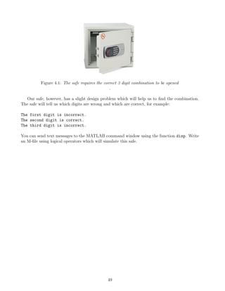
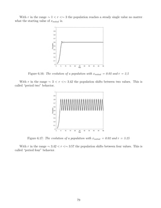
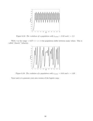
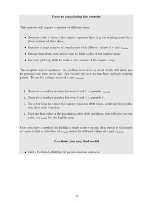
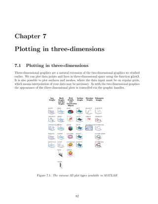
This document provides an introduction to MATLAB for geoscientists. It covers obtaining MATLAB and useful resources, the basic MATLAB interface and commands, working with variables and simple operations, built-in functions, logical operators and flow control, importing and exporting data, 2D and 3D plotting, interpolation, optimization, and image analysis. The goal is to provide geoscientists with the fundamental MATLAB skills needed to perform common scientific tasks.


![2.1.6 Simple Arrays
In many cases we would like to use variables that contain more than a single number, these
are arrays. Arrays can be rows or columns of numbers (called vectors) or higher dimensional
matrices (two-dimensions or higher). To form an array in MATLAB you should use the square
bracket symbols [ and ]. First lets make a row vector which contains the numbers 12, 35.2, and
65.
>> x = [12 , 35.2 , 65]
x =
12.0000 35.2000 65.0000
The , symbol places the numbers in a row. To place the numbers in a column use the ;
symbol:
>> x = [12 ; 35.2 ; 65]
x =
12.0000
35.2000
65.0000
There are a number of shortcuts when making vectors, for example, we can produce a row
vector which contains numbers starting at 0.8 and finishing at 1.4 spaced at 0.15 intervals:
>> x = [0.8 : 0.15 : 1.4]
x =
0.8000 0.9500 1.1000 1.2500 1.4000
Note the use of the : operator to tell MATLAB to make an equal interval array. To make
a column with the same numbers we have to add the transpose command ' after the square
brackets:
>> x = [0.8 : 0.15 : 1.4]'
x =
0.8000
0.9500
1.1000
1.2500
1.4000
18](https://image.slidesharecdn.com/anintroductiontomatlabforgeoscientists-231208112439-be4fa83c/85/An-Introduction-to-MATLAB-for-Geoscientists-pdf-19-320.jpg)
![If we have a long vector we may only be interested in certain parts of it, we can access those
parts using an index number. Index numbers represent specific positions within an array start-
ing from the first position which is given an index of 1. For example if we want to know the
value of x at a given position:
>> x = [0.8 : 0.15 : 1.4];
>> x(3) %return the 3rd element of x
ans =
1.1000
>> x(5) %return the 5th element of x
ans =
1.4000
>> x(1:3) %the 1st through 3rd elements of x
ans =
0.8000 0.9500 1.1000
>> x([1 , 4 , 3]) %return the 1st, 4th and 3rd elements of x
ans =
0.8000 1.2500 1.1000
>> x([1 : 2 : 5]) %return the 1st, 3rd and 5th elements of x
ans =
0.8000 1.1000 1.4000
Currently the variable x holds five elements, so if we ask for the sixth we will get an error
because we are looking for a position which does not exist:
>> x(6) %return the 6th element of x
??? Index exceeds matrix dimensions.
You can also perform arithmetic between vectors and scalars. Construct a column vector,
x, and then perform some simple calculations with it and a scalar, producing an output row
vector y:
19](https://image.slidesharecdn.com/anintroductiontomatlabforgeoscientists-231208112439-be4fa83c/85/An-Introduction-to-MATLAB-for-Geoscientists-pdf-20-320.jpg)
![>> x = [0.8 : 0.15 : 1.4]';
>> y = x + 2 %Addition of 2 to all the elements in x
y =
2.8000
2.9500
3.1000
3.2500
3.4000
>> y = x - 3 %Subtraction of 3 from all the elements in x
y =
-2.2000
-2.0500
-1.9000
-1.7500
-1.6000
>> y = x * 1.2 %Multiply all elements by 1.2
y =
0.9600
1.1400
1.3200
1.5000
1.6800
>> y = x / 2.5 %Divide all the elements by 2.5
y =
0.3200
0.3800
0.4400
0.5000
0.5600
>> y = x(1:2) + 5 %Add five to the first two elements
y =
5.8000
20](https://image.slidesharecdn.com/anintroductiontomatlabforgeoscientists-231208112439-be4fa83c/85/An-Introduction-to-MATLAB-for-Geoscientists-pdf-21-320.jpg)
![5.9500
The last type of array we will consider is the matrix which is a two or high dimensional array.
The two dimensional matrix contains rows and columns. To construct a matrix we can use the
, (row command) and ; (column command) operators. Note the use of the ; symbol to start
a new row.
>> x = [1 , 2 , 3 , 4 ; 5 , 6 , 7 , 8]
x =
1 2 3 4
5 6 7 8
When making a matrix all the rows must have the same number of columns (as above where
each row has 4 elements). If you try to make a matrix with rows of different lengths an error
will be returned.
>> x = [1 , 2 , 3 , 4 ; 5 , 6 , 7 , 8 , 9]
??? Error using ==> vertcat
CAT arguments dimensions are not consistent.
A matrix has both rows and columns, so to select elements we must use both row indices
and column indices. The row index is always specified first, then the column index.
>> x = [5.4 , 7.1 , 3.3 , 2.8 ; 1.4 , 6.9 , 9.2 , 3.4]
x =
5.4000 7.1000 3.3000 2.8000
1.4000 6.9000 9.2000 3.4000
>> x(2,1) %return the element in the 2nd row and 1st column
ans =
1.4000
>> x(1,3) %return the element in the 1st row and 2nd column
ans =
3.3000
>> x(2,:) %return all the elements in the 2nd row
ans =
21](https://image.slidesharecdn.com/anintroductiontomatlabforgeoscientists-231208112439-be4fa83c/85/An-Introduction-to-MATLAB-for-Geoscientists-pdf-22-320.jpg)
![1.4000 6.9000 9.2000 3.4000
>> x(:,4) %return all the elements in the 4th column
ans =
2.8000
3.4000
2.1.7 Array-Scalar and Array-Array Arithmetic
When performing addition and subtraction on arrays you must either use an array and a scalar
together or two arrays of the same size. As a first example we will create a matrix and add a
scalar to each of its entries.
>> x = [5.4 , 7.1 , 3.3 , 2.8 ; 1.4 , 6.9 , 9.2 , 3.4]
x =
5.4000 7.1000 3.3000 2.8000
1.4000 6.9000 9.2000 3.4000
>> x + 1 %add 1 to each entry in x
ans =
6.4000 8.1000 4.3000 3.8000
2.4000 7.9000 10.2000 4.4000
Addition of two arrays of the same size means they are added together element by element:
>> x + [1 , 2 , 3 , 4 ; 5 , 6 , 7 , 8]
ans =
6.4000 9.1000 6.3000 6.8000
6.4000 12.9000 16.2000 11.4000
Of course, subtraction will work in the same way. Addition or subtraction of arrays with
different sizes will cause an error:
>> [1 , 2 , 3 ] + [5 , 6 , 7 , 8]
??? Error using ==> plus
Matrix dimensions must agree.
22](https://image.slidesharecdn.com/anintroductiontomatlabforgeoscientists-231208112439-be4fa83c/85/An-Introduction-to-MATLAB-for-Geoscientists-pdf-23-320.jpg)
![There are two types of multiplication and division; element by element and matrix. With
arrays of the same size element by element multiplication, division and exponentiation uses the
. operator. We’ll form two matrices and then perform some element by element operations.
>> x = [1 , 1 , 1 ; 2 , 2 , 2]
x =
1 1 1
2 2 2
>> y = [1 , 2 , 3 ; 4 , 5 , 6]
y =
1 2 3
4 5 6
>> x.*y %element by element multiplication
ans =
1 2 3
8 10 12
>> x./y %element by element division
ans =
1.0000 0.5000 0.3333
0.5000 0.4000 0.3333
>> x.^y %element by element exponentiation
ans =
1 1 1
16 32 64
If you don’t use the . operator MATLAB will perform matrix multiplication or division, but
the arrays must be of the correct size, for example if we try to multiply the arrays x and y:
>> x*y %matrix multiplication of x and y
??? Error using ==> mtimes
Inner matrix dimensions must agree.
23](https://image.slidesharecdn.com/anintroductiontomatlabforgeoscientists-231208112439-be4fa83c/85/An-Introduction-to-MATLAB-for-Geoscientists-pdf-24-320.jpg)
![>> x = [1 , 1 , 1 ; 2 , 2 , 2]'
x =
1 2
1 2
1 2
>> x * y %matrix multiplication of x and y
ans =
9 12 15
9 12 15
9 12 15
24](https://image.slidesharecdn.com/anintroductiontomatlabforgeoscientists-231208112439-be4fa83c/85/An-Introduction-to-MATLAB-for-Geoscientists-pdf-25-320.jpg)
![compasses = 2 %define number of compasses
magnifiers = 9 %define number of magnifiers
%in the next line sum the total cost
cost = hammers*45.32 + compasses*23.17 + magnifiers*4.99
items = hammers + compasses + magnifiers %number of items
average cost = cost /items %calculate average cost
3.2 Working with “inbuilt” functions
The real power of MATLAB comes from its thousands of inbuilt functions. Each function is
a sequence of MATLAB commands which will perform a specific task. Each function has a
specific set of input and outputs according to the information it requires and the result it will
produce. Later we will look at how we can write our own functions to perform a given task,
but for the time being we will look at inbuilt functions to understand how they work.
3.2.1 Taking the square root
To find the square root of a number is simple and we could use standard MATLAB arithmetic
commands. For example to find the square root of 9:
>> 9^0.5
ans =
3
We can perform the same task on a vector as long as we use the element by element ap-
proach:
>> [9 , 16 , 25].^0.5 %note the use of the dot
ans =
3 4 5
This is easy enough, but MATLAB also contains an inbuilt function called sqrt which can
perform this task for us. To use a function we give its name at the command line and place
the input within brackets. The input can be a series of numbers, a variable or an expression
including other variables, finally the output of the function can also be assigned a specific vari-
able name.
>> sqrt(9)
ans =
26](https://image.slidesharecdn.com/anintroductiontomatlabforgeoscientists-231208112439-be4fa83c/85/An-Introduction-to-MATLAB-for-Geoscientists-pdf-27-320.jpg)
![3
The sqrt function can also be used for vectors, matrices and expressions:
>> x = [9 , 16 , 25]
x =
9 16 25
>> sqrt(x)
ans =
3 4 5
>> y = sqrt(2*x+4) %assign the output to y
y =
4.6904 6.0000 7.3485
3.2.2 The help command
If you want information on what a function does and what its inputs and outputs should be
then you can used MATLAB’s help system. Simply give the help command followed by the
name of the function you are interested in. This will provide detailed information on what the
function does, other related functions which might also be useful, and a link to the function’s
page in the help documentation.
>> help sqrt
SQRT(X) is the square root of the elements of X. Complex
results are produced if X is not positive.
See also sqrtm, realsqrt, hypot.
Overloaded functions or methods (ones with the same name in other directories)
help sdpvar/sqrt.m
help ncvar/sqrt.m
help sym/sqrt.m
Reference page in Help browser
27](https://image.slidesharecdn.com/anintroductiontomatlabforgeoscientists-231208112439-be4fa83c/85/An-Introduction-to-MATLAB-for-Geoscientists-pdf-28-320.jpg)
![doc sqrt
3.2.3 Finding the right function
As I mentioned above, MATLAB has thousands of inbuilt functions and sometimes it can be
difficult to guess the name of the function you need to perform a certain task. In these situa-
tions the lookfor function is useful, because it will search for specific keywords within all the
available functions and return a list of matches. For example, if we want to take the square
root of a number but we don’t know the name of the function to use, we can use the lookfor
function to get a list of possibilities:
>> lookfor('square root')
HYPOT Robust computation of the square root of the sum of squares
REALSQRT Real square root.
SQRT Square root.
SQRTM Matrix square root.
ipexConformalForward1 Forward transformation with positive square root.
ipexConformalForward2 Forward transformation with negative square root.
SQRT Symbolic matrix element-wise square root.
Lets take a slightly more complicated example. We want to generate a matrix with 3 rows and
2 columns that contains random numbers taken from a normal distribution. Our first step is to
search for a function which can perform this task:
>> lookfor('random numbers')
RAND Uniformly distributed pseudo-random numbers.
RANDN Normally distributed random numbers.
RANDG Gamma random numbers (unit scale).
From the list it looks like the function randn will provide us with random numbers from a
normal distribution. Next we’ll look at its help entry to get more details concerning the inputs
we should use:
>> help randn
RANDN Normally distributed random numbers.
R = RANDN(N) returns an N-by-N matrix containing pseudo-random values
drawn from a normal distribution with mean zero and standard deviation
one. RANDN(M,N) or RANDN([M,N]) returns an M-by-N matrix. RANDN(M,N,P,...)
or RANDN([M,N,P,...]) returns an M-by-N-by-P-by-... array. RANDN with
no arguments returns a scalar. RANDN(SIZE(A)) returns an array the
same size as A.
28](https://image.slidesharecdn.com/anintroductiontomatlabforgeoscientists-231208112439-be4fa83c/85/An-Introduction-to-MATLAB-for-Geoscientists-pdf-29-320.jpg)
![This tells us the the function will return a matrix of normally distributed random numbers,
the first input to the function is the number of rows for the matrix and the second is the num-
ber of columns (remember we wanted 3 rows and 2 columns). We’ll name our output from the
function z.
>> z = randn(3,2)
z =
-0.4326 1.1909
-1.6656 -1.1465
0.1253 0.2877
3.2.4 Multiple inputs and outputs
It is also possible for functions to work with multiple inputs and outputs. A good example is
the sortrows function which sorts a matrix of values from lowest to highest based on the values
in one of its columns. The primary output of the function is the sorted matrix, but a secondary
output giving the index of the sorted values is also available. First we will sort the random
numbers in z according to the values in the first column (if we don’t specify which column to
base the sort upon, MATLAB will automatically use the first).
>> y = sortrows(z) %sort the rows according to the first column
y =
-1.6656 -1.1465
-0.4326 1.1909
0.1253 0.2877
Now we’ll also use the second (optional) output of the function that records the original indices
of the sorted values (which we will call idx). Note that in order to obtain multiple outputs we
have to group them together in square brackets when calling the function:
>> [y,idx] = sortrows(z) %sort the rows by the first column and return the indices
y =
-1.6656 -1.1465
-0.4326 1.1909
0.1253 0.2877
idx =
29](https://image.slidesharecdn.com/anintroductiontomatlabforgeoscientists-231208112439-be4fa83c/85/An-Introduction-to-MATLAB-for-Geoscientists-pdf-30-320.jpg)
![2
1
3
Finally, we’ll supply the function with a second (optional input argument) which gives the index
of the column upon which the sort should be based. In this case we will sort according to the
values in the second column:
>> [y,idx] = sortrows(z,2)
y =
-1.6656 -1.1465
0.1253 0.2877
-0.4326 1.1909
idx =
2
3
1
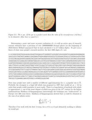
3.3 Exercise: Mmmm, π
Now it’s your turn. Throughout the class we will attempt to solve problems using MATLAB
by applying the topics which have been discussed. Some of you may find them relatively easily
(especially if you have some experience of MATLAB) and others will find them more difficult. I
have specifically designed the exercises to be challenging, so don’t expect to finish them within
a few minutes. It is important to realize that MATLAB is a tool and will only help you to solve
a problem if you know how the problem should be solved. The first question you should ask
yourself is “what method will I used to solve the problem?” and only then should you think
about “how can I implement my method in MATLAB?”. For this first exercise we are going to
look at a simple numerical problem involving π.
Approximating π
The value of π has a very simple definition, “the ratio of a circle’s circumference to its diameter”,
but it is irrational number, meaning its decimal representation never ends or repeats.
30](https://image.slidesharecdn.com/anintroductiontomatlabforgeoscientists-231208112439-be4fa83c/85/An-Introduction-to-MATLAB-for-Geoscientists-pdf-31-320.jpg)
![When you try to save the function, MATLAB will suggest the same name as you defined for the
function (simple.m). When searching for a function MATLAB actually refers to the filename
rather than the defined name inside the function, so it’s essential that they match each other.
Now we can call the function simple in the same way as any other MATLAB function. For
example:
>> x = 5
>> y = simple(x)
y =
6
The the names of the input, x, and output, y, are only used within the function, so when
we are calling the function externally (i.e. from outside) we can use any names we want. For
example:
>> a = 5
>> b = simple(a)
b =
6
One of the advantages of M-functions is that all the variables which may be created by the
intermediate steps of the function will not be stored in the MATLAB memory once the calcula-
tion is complete, only the output is stored. This makes functions a very tidy way of performing
certain tasks because only the output is stored. We can set multiple inputs and outputs sim-
ply by adding them to the first line of the function. The next function we’ll write is called
simple2.m, which takes two inputs c and d and gives two outputs, e which is the difference of c
and d, and f which is the sum of c and d. Note that comments can also be included to explain
the steps of the function.
function [e,f]=simple2(c,d)
e = c - d; %find the difference
f = c + d; %find the sum
Now we must supply two input names and two output names. For example:
>> cats=7;
>> dogs=4;
>> [shirt,socks]=simple2(cats,dogs)
shirt =
3
34](https://image.slidesharecdn.com/anintroductiontomatlabforgeoscientists-231208112439-be4fa83c/85/An-Introduction-to-MATLAB-for-Geoscientists-pdf-35-320.jpg)
![socks =
11
Hopefully this will convince you that you can use any variable names, of course it is always best
to use meaningful names which describe the variable.
Including help and comments
One key aspect of writing functions is including detailed help so that other people can use your
function and comments which show how the calculations are performed. Often you will write
a function and after not looking at it for a few months you will have forgot how it works or
how to use it. In these situations the help information and comments are invaluable. Help is
entered after the first line of the file and is basically a series of comments, however, because of
their position MATLAB can find them whenever you use the help or lookfor functions.
We take an example from probably the worlds most famous equation, the mass-equivalence
relationship:
E = mc2
where E is energy, m is mass and c is the speed of light. We can write a vanilla function (i.e.
the most simple form) without help or comments.
function E=massequiv0(m)
c = 299792458;
E = m*c^2;
In this form the function will work and return the correct answer. It is obvious what is hap-
pening because we are only performing a simple operation. However some functions require
thousands of lines of code, thus it is very easy to become lost and the meanings of different
variable names maybe obscure. Therefore it is always a good idea to include some comments
that describe what is happening in the different lines of code. For an equation such as this it is
also a good idea to state which units are being used.
function E=massequiv1(m)
c = 299792458; %speed of light [m s^-1]
E = m.*c.^2; %calculate the energy in Joules [kg m^2 s^-2]
Things are starting to improve, but we still have to include the help information. The help is
essential because it describes what the function does and what the different inputs and outputs
represent.
35](https://image.slidesharecdn.com/anintroductiontomatlabforgeoscientists-231208112439-be4fa83c/85/An-Introduction-to-MATLAB-for-Geoscientists-pdf-36-320.jpg)
![function E=massequiv2(m)
%massequiv2 - Find energy from mass based on Einstein (1905)
%
% Syntax: energy = massequiv2(mass)
%
% Inputs:
% m - mass [kg]
%
% Outputs:
% E - equivalent energy [Joules or kg m^2 s^-2]
%
% Other m-files required: none
% Subfunctions: none
% MAT-files required: none
%
% Author: Dave Heslop
% Department of Geosciences, University of Bremen
% email address: dheslop@uni-bremen.de
% Last revision: 6-Dec-2008
%------------- BEGIN CODE --------------
c = 299792458; %speed of light [m s^-1]
E = m.*c.^2; %calculate the energy in Joules [kg m^2 s^-2]
%------------- END CODE --------------
With the help information in place we can use the lookfor and help functions:
>> lookfor Einstein
>> help massequiv2
36](https://image.slidesharecdn.com/anintroductiontomatlabforgeoscientists-231208112439-be4fa83c/85/An-Introduction-to-MATLAB-for-Geoscientists-pdf-37-320.jpg)
![>> A ∼= B %test if A does not equal B
ans =
1
>> A >= B %test if A is greater than or equal to B
ans =
0
>> A < B %test if A is less than B
ans =
1
When we work with arrays the relationships are tested on a element-by-element basis. The
output will be the same size as the array being tested, with the position of ones and zeros in
the output corresponding to the elements being tested:
>> A = [1:1:5]
A =
1 2 3 4 5
>> B = [5:-1:1]
B =
5 4 3 2 1
>> A >= 4 %positions where A is greater-than or equal to 4
ans =
0 0 0 1 1
>> A == B %positions where A equals B
ans =
0 0 1 0 0
>> B < A %positions where B is less-than A
41](https://image.slidesharecdn.com/anintroductiontomatlabforgeoscientists-231208112439-be4fa83c/85/An-Introduction-to-MATLAB-for-Geoscientists-pdf-42-320.jpg)
![ans =
0 0 0 1 1
In the case where the two arrays are not the same size, MATLAB will return an error be-
cause it is not possible to perform an element-by-element comparison:
>> A = [1:1:4]
A =
1 2 3 4
>> B = [1:1:3]
B =
1 2 3
>> A == B
??? Error using ==> eq
Matrix dimensions must agree.
A particularly useful function which extends the use of the relational operators is find. This
function returns the indices of positions within an array which return a True from the test
relation. In the following example we’ll use find to locate the numbers in the array which are
greater than or equal to three:
>> A = [5:-1:1]
A =
5 4 3 2 1
>> idx = find(A>=3) %index of values less than or equal to 3
idx =
1 2 3
>> A(idx) %test the result by calling the indexed values
ans =
5 4 3
42](https://image.slidesharecdn.com/anintroductiontomatlabforgeoscientists-231208112439-be4fa83c/85/An-Introduction-to-MATLAB-for-Geoscientists-pdf-43-320.jpg)
![4.1.2 Logical Operators
Logical operators allow us to combine a series of relational expressions. In this way we can
specify in detail a series of relations which a given number must meet or not meet.
Logical Operator Description
& AND
| OR
∼ NOT
As a first example we’ll compare to vectors A and B to find where A is greater than B, with the
added condition that the only results which are acceptable are those where A does not equal 5.
>> A = [1:1:5]
A =
1 2 3 4 5
>> B = [5:-1:1]
B =
5 4 3 2 1
>> A > B & A∼=5 %find A is greater than B and A does not equal 5
ans =
0 0 0 1 0
We can see from this result that the fifth element of A meets the first requirement (>B), but not
the second (∼=5), so a result of False is returned. Only the fourth element of meets both re-
quirements. The logical operators can also be included when using the find function. We’ll work
with the same variable B, and find the values which are less than or equal to 2 or greater than 4.
>> idx = find(B<=2 | B>4)
idx =
1 4 5
>> B(idx) %check the result
ans =
43](https://image.slidesharecdn.com/anintroductiontomatlabforgeoscientists-231208112439-be4fa83c/85/An-Introduction-to-MATLAB-for-Geoscientists-pdf-44-320.jpg)
![1
i =
2
i =
3
i =
4
i =
5
We can see that the loop repeats between the for and end statements for each value of i,
we can set as many i values and in any sequence we want. For example:
>> for i=[3 7 -1]
i %print the value of i on the screen
>> end
i =
3
i =
7
i =
-1
For a more complicated example we will return to our approximation of π. If you remem-
ber we employed the infinite series of Madhava of Sangamagrama who showed that π
4
:
∞
X
n=0
(−1)n
2n + 1
=
π
4
Therefore if we work with the first 4 terms, for n=0 to n=3 and ultimately working to infinity
we would get:
(−1)0
2 ∗ 0 + 1
+
(−1)1
2 ∗ 1 + 1
+
(−1)2
2 ∗ 2 + 1
+
(−1)3
2 ∗ 3 + 1
+ . . .
(−1)∞
2 ∗ ∞ + 1
=
π
4
We can easily perform this calculation within a for loop, which the value of n increasing from
0 to 10000. For each iteration we will simple add the new term to the existing estimate of π.
>> p=0; %set our starting estimate to 0
>> for n=0:1e5 %loop between 0 and 10000
46](https://image.slidesharecdn.com/anintroductiontomatlabforgeoscientists-231208112439-be4fa83c/85/An-Introduction-to-MATLAB-for-Geoscientists-pdf-47-320.jpg)
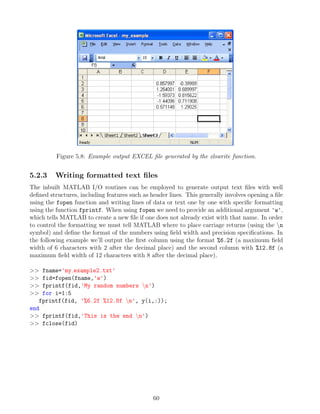
![Figure 5.9: Example of formatted output using the fprintf function.
5.3 Data Management
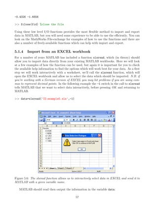
MATLAB is particular useful for managing and storing large data sets. Specific values from
specific variables can be recalled quickly with a single statement rather than the tiring mouse
work which is required with spreadsheets. In order to manage our data in a well organized
manner we can use so-called structural arrays which allow data of varying types and sizes to
be stored in fields. The fields form a hierarchy within the structure with each field representing
a property or attributes that we want to associate data with. Using fields we can build up
layers of data in a logical manner. To see how this would work we’ll now look at an example,
building up a structural array to contain the information for the sediment core MD962094. The
information we want to store concerning the core is as follows.
1. Position (latitude, longitude, water depth)
2. The ship name and date the core was recovered
3. Available data (in this case depth and the color reflectance at 400 and 700 nm)
The first thing we need to decide on is a name for the structural array, it would seem sensible
to use the name of the core: MD962094. The first information we’ll input is the waterdepth of
the core (giving both the value 2280.0 and the units “m”), which we will store in a higher level
field called position. Notice how the path through the hierarchy of fields is controlled by the
dot operator.
>> MD962094.position.waterdepth.value=2280.0
>> MD962094.position.waterdepth.units='m'
Note that when inputting the units a text string is used to store characters rather than numbers.
We can now interrogate the variable at different levels again using the dot operator:
>> MD962094
MD962094 =
position: [1x1 struct]
>> MD962094.position
61](https://image.slidesharecdn.com/anintroductiontomatlabforgeoscientists-231208112439-be4fa83c/85/An-Introduction-to-MATLAB-for-Geoscientists-pdf-62-320.jpg)
![ans =
waterdepth: [1x1 struct]
>> MD962094.position.waterdepth
ans =
value: 2280
units: 'm'
>> MD962094.position.waterdepth.value
ans =
2280
Entering the remainder of the data follows the same pattern and as before the names that
we use are arbitrary (they could be anything but is is always best to choose something mean-
ingful). First we’ll finish the position information by including the latitude and longitude:
>> MD962094.position.latitude.units='degrees'
>> MD962094.position.latitude.value=-20.0
>> MD962094.position.longitude.units='degrees'
>> MD962094.position.longitude.value=9.265
Next we’ll enter the ship name and the date the core was recovered:
>> MD962094.ship = 'Marion Dufresne'
>> MD962094.date = 'Y1996 M10 D13'
Finally we can enter the colour reflectance data itself (we’ll only enter the first few values
to save space on the page) in each case defining both the values of the data and their units:
>> MD962094.data.reflectance.depth.units='m'
>> MD962094.data.reflectance.depth.value=[0.05;0.1;0.15]
>> MD962094.data.reflectance.nm400.units='%'
>> MD962094.data.reflectance.nm400.value=[19.65;21.44;18.40]
>> MD962094.data.reflectance.nm700.units='%'
>> MD962094.data.reflectance.nm700.value=[35.26;36.35;34.08]
If you are working with date sets from a number of a different cores then you can store their data
in a series of structural variables with a consistent structure, then it is simple to call precisely
the data you want for any given core. Lets imagine that we want to find the maximum value of
the 400 nm reflectance data:
>> max(MD962094.data.reflectance.nm400.value)
ans =
36.3500
62](https://image.slidesharecdn.com/anintroductiontomatlabforgeoscientists-231208112439-be4fa83c/85/An-Introduction-to-MATLAB-for-Geoscientists-pdf-63-320.jpg)
![Chapter 6
Plotting in two-dimensions
6.1 Plotting in two-dimensions
MATLAB can be used to produce a wide variety of plots thanks to its comprehensive graphics
libraries. The appearance of plots can be controlled from the command line, which means that
you can include automatic plotting in your script files and M-functions. Many more specialized
types of graphics which are not included in the distributed version of MATLAB are available
on the File-Exchange.
6.1.1 Figure windows
To create a figure window into which a plot can be placed simply give the command:
>> figure
This will produce a blank window. At this point it is important to realize that the figure
windows has certain properties, called Figure Object Properties, which we may want to change
in order to modify the overall appearance of our final graphic. We can look at these properties
using the get function with the gcf specifier which corresponds to the handle of the current
figure.
>> get(gcf)
The text listed on the screen gives the figure’s properties on the left and their current state
on the right. For example, lets look at the color of the figure, we can either look through the
returned list or request only the color property using the get function:
>> get(gcf,'color') %request only the color property
ans =
0.8000 0.8000 0.8000
The returned values correspond to the RGB value of the current figure color (values can range
between 0 and 1, where [0 0 0] would be black and [1 1 1] would be white). If we want to change
64](https://image.slidesharecdn.com/anintroductiontomatlabforgeoscientists-231208112439-be4fa83c/85/An-Introduction-to-MATLAB-for-Geoscientists-pdf-65-320.jpg)
![the color of the figure, for example to red we use the set function and provide the appropriate
color vector (in this case [1 0 0]):
>> set(gca,'color',[1 0 0]) %reset the color property
Now when you look at the figure it should be red (a set of axes may also have appeared).
MATLAB figures and plots are all controlled by adjusting the properties of the handles, just as
in the example we performed.
6.1.2 Using Handles
At first the use of handles can seem like a very complicated way of controlling the appearance
of graphics compared to software such as EXCEL where you just need to double-click to change
items. The advantage of using handles is that we can include adjustments to our figures and
plots in script files, so with a bit of programming the appearance of a graphic can be optimized
automatically. Understanding and using handles takes some time, especially remembering the
specific property names which you may want to adjust. Over time you will remember the
important handle properties and for the more obscure ones the MATLAB help system can tell
you what they do and how they can be adjusted. Throughout the following examples we will
be using handles to modify graphics, so it is important to be familiar with the following simple
specifiers.
• gcf specifies the current figure handle
• gca specifies the current axes handle
• gco specifies the current graphic object handle
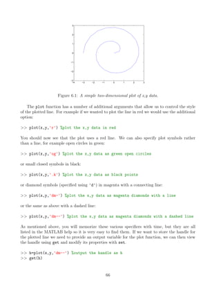
6.2 Simple data plotting
Now we’ll generate some simple x,y data and then plot it using the plot function:
>> t = linspace(0,3*pi,30); %30 point equally spaced vector between 0 and 3pi
>> x = sqrt(t).*cos(t); %calculate the x values
>> y = sqrt(t).*sin(t); %calculate the y values
>> figure %create a new figure window
>> plot(x,y) %plot the x,y data
65](https://image.slidesharecdn.com/anintroductiontomatlabforgeoscientists-231208112439-be4fa83c/85/An-Introduction-to-MATLAB-for-Geoscientists-pdf-66-320.jpg)
![Listed on the screen you’ll see the properties of the plotted data, for example you can see
the LineStyle is '--' just as it was set in the plot command and the Marker is 'diamond'.
As an example of modifying the handle we’ll set the color to red, the symbols to squares, the
size of the symbols to 12 points, the lines to be dot-dashed and to have a thickness of 2 points.
>> set(h,'color',[1 0 0]) %set the color to red
>> set(h,'marker','square') %set the symbols as squares
>> set(h,'markersize',12) %set the symbol size to 12 pts
>> set(h,'linestyle','-.') %set the line to dot-dashed
>> set(h,'linewidth',2) %set the line thickness to 2 pts
−4 −3 −2 −1 0 1 2 3
−3
−2
−1
0
1
2
3
Figure 6.2: A two-dimensional plot of x,y data, the appearance of which has been changed using
its handle.
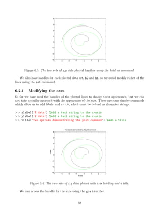
At anytime we can plot additional data onto the graphic. Now we’ll generate a second data
set and add it to the plot.
>> x1=-y; %create a new x array
>> y1=-x; %create a new y array
>> h1=plot(x1,y1,'g') %plot the data as a green line with the handle h1
When we look at the figure we can see that there is a problem, the old line has been re-
moved from the plot and replaced with the new line. If we want to show both lines on the same
plot we need to use the hold on command, which tells MATLAB to add data to the graphic
rather than replacing it.
>> h0=plot(x,y,'k') %plot the data as a black line with the handle h0
>> hold on %tells MATLAB we want to add to the plot
>> h1=plot(x1,y1,'g') %plot the data as a green line with the handle h1
67](https://image.slidesharecdn.com/anintroductiontomatlabforgeoscientists-231208112439-be4fa83c/85/An-Introduction-to-MATLAB-for-Geoscientists-pdf-68-320.jpg)
![>> get(gca)
As you can see there are a large number of properties and we can change any of them using the
set command. As with the other handles it is important to check the MATLAB documentation
to find what the allowable states for any given property are. The following sets of commands
show some of the properties that can be changed, enter them one by one each time checking
the figure to see how things have changed.
>> set(gca,'tickdir','out') %tick marks point outwards rather than inwards
>> set(gca,'yminortick','on') %plot intermediate ticks on the y-axis
>> set(gca,'fontsize',16) %set the text size to 16 points
>> set(gca,'xdir','reverse') %reverse the direction of the x-axis
>> set(gca,'ylim',[-2 2]) % set the y-axis range as -2 to 2
>> set(gca,'yaxislocation','right') %place the y-axis on the right hand side
>> set(gca,'xgrid','on') %plot a grid over the x-axis
>> set(gca,'fontangle','italic') %use italic fonts
>> set(gca,'xtick',[-4 -2 0 1 2.5 3.7]) %plot xticks at specific values
−4
−2
0
1
2.5
3.7
−2
−1
0
1
2
X data
Y
data
Two spirals demonstrating the plot command
Figure 6.5: The two sets of x,y data plotted with a collection of modifications to the axes.
As you can see you can change every aspect of a graphic using the handles, all you need to
know is the name of the property you want to change.
6.2.2 Multiple sets of axes in a single figure
Often you will want to plot and compare a number data sets within a single figure window, this
can be done using the axes command or its extension subplot. When we create a new figure
window we can place axes in a specific position with a specific size. The axes command has
4 numerical inputs entered as a position vector axes('position', RECT), where RECT = [left,
bottom, width, height] specifies the location and size of the side of the axis box, relative to the
lower-left corner of the Figure window, in normalized units where (0,0) is the lower-left corner
69](https://image.slidesharecdn.com/anintroductiontomatlabforgeoscientists-231208112439-be4fa83c/85/An-Introduction-to-MATLAB-for-Geoscientists-pdf-70-320.jpg)
![and (1.0,1.0) is the upper-right. In this first example we’ll make a figure with two sets of axes
and plot our spiral data separately.
>> close all %close the existing figure windows
>> figure %create a new figure window
Now we’ll form a set of axes which have their bottom left corner located at (0.1,0.2) a width of
0.3 and a height of 0.7. We’ll then plot the x,y data inside the axes.
>> axes('position',[0.1 0.2 0.3 0.7]) %create specific axes
>> plot(x,y,'b') %plot x and y in blue
Lets add a second set of axes which have there bottom left corner located at (0.5,0.4) a width
of 0.4 and a height of 0.2. Then we’ll plot the data set x1,y1 inside the axes.
>> axes('position',[0.5 0.4 0.4 0.2]) %create specific axes
>> plot(x1,y1,'r') %plot x1 and y1 in red
−4 −2 0 2 4
−3
−2
−1
0
1
2
3
−4 −2 0 2 4
−5
0
5
Figure 6.6: User specified axes within a single figure window.
If you would like to create a set of regularly sized and spaced axes then you can use the
subplot command. subplot requires 3 inputs, the number of rows of axes, the number of
columns of axes and which set of axes it should make active. This may sound confusing but
hopefully the example will make things clear, we’ll construct 6 sets of axes in a grid with 2
rows and 3 columns. When we specify the active axes (the third input of subplot) they are
numbered in a sequence which runs from left to right along each row from top to bottom. To
demonstrate this concept we’ll use the axes out of their natural sequence. Remember to keep
looking at the figure to see how it evolves with each command.
>> close all %close the existing figure windows
>> figure %create a new figure window
>> subplot(2,3,1) %2 rows & 3 columns of axes, use position 1
70](https://image.slidesharecdn.com/anintroductiontomatlabforgeoscientists-231208112439-be4fa83c/85/An-Introduction-to-MATLAB-for-Geoscientists-pdf-71-320.jpg)
![>> plot(rand(20,1),rand(20,1),'o') %plot some random data
>> title('2 x 3 form, position 1')
>> subplot(2,3,5) %2 rows & 3 columns of axes, use position 5
>> plot(rand(20,1),rand(20,1),'o') %plot some random data
>> title('2 x 3 form, position 5')
As with our previous examples, we can output the handle for a specific set of axes created
by subplot and use it to modify the axes properties.
>> h3=subplot(2,3,3) %2 rows & 3 columns of axes, use position 3, return the handle
>> plot(rand(20,1),rand(20,1),'o') %plot some random data
>> title('2 x 3 form, position 3')
>> set(h3,'color',[1 0 0]) %set these axes to be red
0 0.5 1
0
0.2
0.4
0.6
0.8
1
2 x 3 form, position 1
0 0.5 1
0
0.2
0.4
0.6
0.8
1
2 x 3 form, position 5
0 0.5 1
0
0.2
0.4
0.6
0.8
1
2 x 3 form, position 3
Figure 6.7: A regular sequence of axes formed using the subplot command.
6.2.3 Different types of plots
So far we have only used the plot command, but MATLAB can make many different types of 2D
plots. All these plotting functions work in a similar way (use help or the online documentation
to understand how each is used), form a basic plot of the data and then customize the graphic
using the handles to modify specific properties. Shown below is a graphic displaying the different
types of plots, there are many more on the File-Exchange and of course you can even write your
own plot functions.
71](https://image.slidesharecdn.com/anintroductiontomatlabforgeoscientists-231208112439-be4fa83c/85/An-Introduction-to-MATLAB-for-Geoscientists-pdf-72-320.jpg)
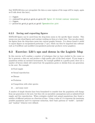
![Figure 6.8: The various 2D plot types available in MATLAB
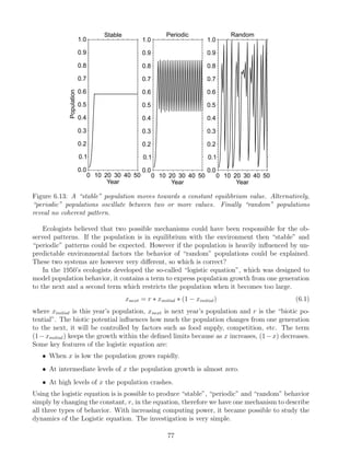
6.2.4 Contour plots
One specific type of plot that as geoscientists we must pay attention to is the contour plot.
MATLAB has inbuilt functions to plot contour maps, but at a first glance the form of the
input data can appear to be a bit confusing. To contour spatial data we must of course have
two location coordinates, for example latitude and longitude, and some measured parameter
such as sea-surface temperate. Most often we collect these kind of data as a series of [x,y,z]
triplets, forming three columns of data. Unfortunately MATLAB does not follow this system
(not surprisingly we need to use a matrix form for data input), so we have to perform some
preprocessing before we can contour data. As an example of the form in which MATLAB can
plot x,y,z data we’ll use peaks which is a function of two variables, obtained by translating and
scaling Gaussian distributions. We’ll generate and plot the peaks function for 20 x 20 data grids.
>> clear all, close all
>> n=20; %number of grid points
>> [x,y,z]=peaks(n); %evaluate peaks on a 20 x 20 grid
>> size(x) %we can see the size of x
ans =
20 20
>> contour(x,y,z,10) %plot data with 10 contours
>> colorbar %add a colorbar to show the z values
72](https://image.slidesharecdn.com/anintroductiontomatlabforgeoscientists-231208112439-be4fa83c/85/An-Introduction-to-MATLAB-for-Geoscientists-pdf-73-320.jpg)
![−3 −2 −1 0 1 2 3
−3
−2
−1
0
1
2
3
−4
−2
0
2
4
6
Figure 6.9: Contour plot of the peaks function evaluated on a 20 x 20 grid.
To understand the form of the matrices MATLAB uses as inputs for its contouring functions
we’ll evaluate the peaks function on a smaller 4 x 4 grid.
>> clear all, close all
>> n=4; %number of grid points
>> [x,y,z]=peaks(n); %evaluate peaks on a 4 x 4 grid
>> x
x =
-3 -1 1 3
-3 -1 1 3
-3 -1 1 3
-3 -1 1 3
>> y
y =
-3 -3 -3 -3
-1 -1 -1 -1
1 1 1 1
3 3 3 3
This shows us how the inputs of the spatial coordinates are organized. The horizontal co-
ordinate, x in this case, has columns of constant value and rows with varying values, while the
vertical coordinate, y, shows the opposite pattern (basically x and y are defining a grid of loca-
tions). Not only do the inputs for the contouring routines need to be in matrix form but they
must be equally spaced in both directions, you can see in the example above that the spacing
is equal to 2 units. So before we can contour our data we must interpolate our collection of
[x,y,z] triplets on to an equally spaced grid of x and y values (this is the same as the gridding
step in SURFER). As an example of how to grid data and plot it we will work with a simple
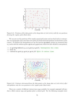
73](https://image.slidesharecdn.com/anintroductiontomatlabforgeoscientists-231208112439-be4fa83c/85/An-Introduction-to-MATLAB-for-Geoscientists-pdf-74-320.jpg)
![topographic data set which is stored in the file dmap.mat with the variables x, y and z.
>> clear all, close all
>> load dmap %load the data file
>> plot(x,y,'or') %plot the positions of the measured data points
>> xlabel('x coordinate') %label the x axis
>> ylabel('y coordinate') %label the y axis
0 1 2 3 4 5 6 7
0
1
2
3
4
5
6
7
x coordinate
y
coordinate
Figure 6.10: Positions of the data points in the dmap data set
The first thing to note is that our data is in columns not matrices and that the points were
not measured on a regular grid. Now we must create some regular grids onto which we can
interpolate the data. To do this we’ll use the meshgrid function which takes equally spaced
vectors and forms them into grids.
>> xi=[0:0.25:6.5]; %equally spaced row vector of x positions
>> yi=[0:0.25:6.5]; %equally spaced column vector of y positions
>> [xi grid,yi grid]=meshgrid(xi,yi);
>> plot(xi grid,yi grid,'.k') %plot the grid positions
74](https://image.slidesharecdn.com/anintroductiontomatlabforgeoscientists-231208112439-be4fa83c/85/An-Introduction-to-MATLAB-for-Geoscientists-pdf-75-320.jpg)
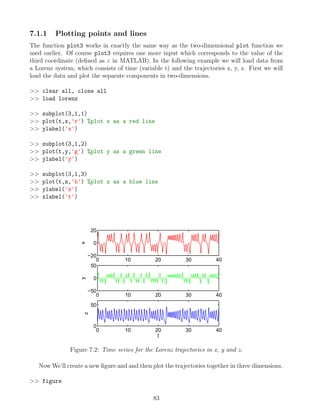
![>> plot3(x,y,z) %plot trajectories together in 3D
>> xlabel('x trajectory') %label the x-axis
>> ylabel('y trajectory') %label the y-axis
>> zlabel('z trajectory') %label the z-axis
>> title('Trajectories for the Lorenz system')
−20
0
20
−40
−20
0
20
40
0
10
20
30
40
50
x trajectory
Trajectories for the Lorenz system
y trajectory
z
trajectory
Figure 7.3: Lorenz trajectories in x, y and z.
We’ve now done the basics but we can use the graphics handles to improve the appearance
of the plot. In particular the default orientation of the plot (termed the camera position) does
not provide the best view of the data structure (you can rotate the data manually using the
Rotate3D button). First we’ll add grids to plot box and then modify the property CameraPo-
sition using the axes handle to provide a better view of the data.
>> set(gca,'xgrid','on','ygrid','on','zgrid','on') %plot grids
>> set(gca,'cameraposition',[200 -200 200]); %change the orientation
84](https://image.slidesharecdn.com/anintroductiontomatlabforgeoscientists-231208112439-be4fa83c/85/An-Introduction-to-MATLAB-for-Geoscientists-pdf-85-320.jpg)
![−20
−10
0
10
20 −40
−20
0
20
40
0
10
20
30
40
50
y trajectory
Trajectories for the Lorenz system
x trajectory
z
trajectory
Figure 7.4: Lorenz trajectories in x, y and z, plotted with grids and rotated to provide a clear
view of the data. Note the values for the CameraPosition were obtained by gradual modification
until a satisfactory position was found.
7.1.2 Surface plots
Earlier we used two-dimensional contour maps to represent topographic data, but MATLAB
also has the capacity to represent such data in a three-dimensional manner using surfaces and
meshes. As with our contour data the input for such plots must be composed of regular grids,
so we need to preprocess our data using meshgrid and griddata.
>> clear all, close all
>> load dmap %load the data file
>> xi=[0:0.25:6.5]; %equally spaced row vector of x positions
>> yi=[0:0.25:6.5]; %equally spaced column vector of y positions
>> [xi grid,yi grid]=meshgrid(xi,yi);
>> zi grid=griddata(x,y,z,xi grid,yi grid); %interpolate the z data
Now we’ll create a surface plot of the data, add the original data on top, rotate the surface
and make it slightly transparent. Feel free to experiment with the handle of the surface (which
will be called hs) to see what effects you can create.
>> h=surf(xi grid,yi grid,zi grid) %create a surface plot
>> hold on %add to the plot
>> hs = plot3(x,y,z,'ok','markerfacecolor','k') %original data points
>> set(h,'facealpha',0.5) %surface is semitransparent
>> xlabel('x') %label the x-axis
>> ylabel('y') %label the y-axis
>> zlabel('Height') %label the z-axis
>> set(gca,'cameraposition',[-21.5 44.2 2691]) %rotate the plot
85](https://image.slidesharecdn.com/anintroductiontomatlabforgeoscientists-231208112439-be4fa83c/85/An-Introduction-to-MATLAB-for-Geoscientists-pdf-86-320.jpg)
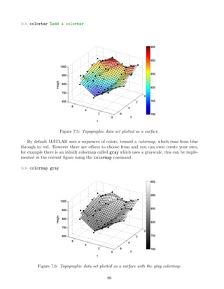
![There are a variety of different ways in which we could have represented the topographic
data in the example, see figure 7.1
7.1.3 Overlaying images
To demonstrate the flexibility of the graphics routines in MATLAB we’ll now look at a more
complicated example, that involves plotting a satellite image of the earth on top of a sphere.
We will read the satellite image (in the form of a jpg) directly from a internet location and store
it as a matrix.
>> clear all, close all
>> filename = 'http://veimages.gsfc.nasa.gov/2430/land ocean ice 2048.jpg';
>> cdata = imread(filename); %read the image from the given location
>> size(cdata) %size of the image data
ans =
1024 2048 3
Note that the size of the image data is 1024 rows (latitude), 2048 columns (longitude) and
3 layers. Each layer provides information on a given color channel, red, green and blue. Now
we will produce a collection of data points which lie on a sphere, which will form the basis of
our Earth:
>> [x, y, z] = sphere(72); %generate data points on a sphere
>> figure %open a new figure window
>> h = surf(x,y,z) %plot a surface from the sphere data
>> axis vis3d %set the axis perspective suitable for 3D
87](https://image.slidesharecdn.com/anintroductiontomatlabforgeoscientists-231208112439-be4fa83c/85/An-Introduction-to-MATLAB-for-Geoscientists-pdf-88-320.jpg)
![−1
0
1
−1
0
1
−1
−0.5
0
0.5
1
Figure 7.7: Surface plot of the data points produced by the sphere function. We will replace the
colors of the panels with those from the downloaded satellite image.
As a final step we use the handle of the plotted surface (our sphere) to replace the existing
colors of the panels with the colors obtained from the downloaded jpg (which are now stored in
the variable cdata):
>> set(h, 'facecolor', 'texturemap') %prepare the panels to be colored
>> set(h,'cdata', cdata); %color the panels with the jpg data
>> set(h,'edgecolor', 'none'); %remove lines between panels
>> set(gca,'visible','off'); %hide the axes box
>> set(gcf,'color',[0 0 0]); %set the background color to black
Figure 7.8: Surface plot of the data points produced by the sphere function with the colors of the
panels based on the downloaded satellite image.
You can now use the Rotate3D and Zoom buttons to navigate around your Earth.
88](https://image.slidesharecdn.com/anintroductiontomatlabforgeoscientists-231208112439-be4fa83c/85/An-Introduction-to-MATLAB-for-Geoscientists-pdf-89-320.jpg)
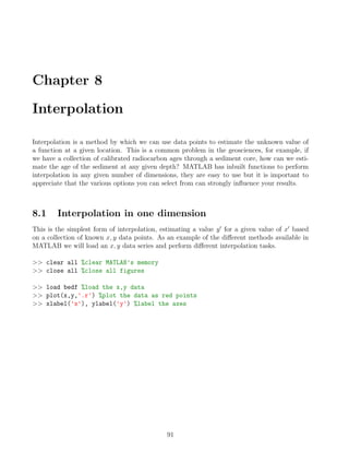
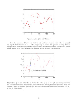
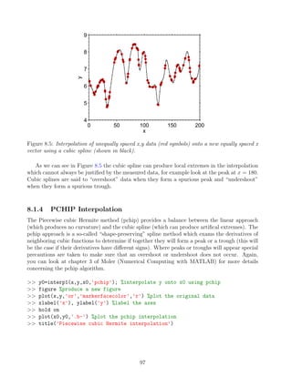
![8.1.1 Piecewise Linear Interpolation
The full name of the approach we have just discussed is “piecewise linear interpolation”, because
the data is split into a series of consecutive pieces and each one is fit with a linear function. The
task can be performed simply in MATLAB using the function interp1, the information we need
to supply is the measured x data (first argument), the measured y data (second argument), the
x0
value for the interpolation (third argument) and the interpolation method to use, which in
this case is 'linear'.
>> y0=interp1(x,y,41,'linear') %using the (x,y) data make a linear estimate of
y at x=41
y0 =
6.3357
It is important to note that when performing interpolation the x-data must be distinct, in
other words you can’t have any repeat points on the x-axis. MATLAB will return an error if
you supply repeat x-values, so in some cases it is necessary to prepare your data before process-
ing. We’ll test this using indexing in order to enter the first values in x and y into the interp1
function twice.
>> y0=interp1(x([1 1:end]),y([1 1:end]),41,'linear')
??? Error using ==> interp1 at 261
The values of X should be distinct.
When performing interpolation with the interp1 function we don’t need to limit ourselves
to determining single values. If we supply the function with a vector of x0
values it will perform
the interpolation for each one. This is very useful for a lot of time series analysis techniques
which assume that you have equally spaced data. If your measured data isn’t equally spaced
then you can simply interpolate it to produce a suitable new data series. Now we’ll work with
the same x, y data as above, but interpolate it onto equally spaced x0
-locations in the range
0 ≤ x0
≤ 200 and with a interval in x0
of 1 unit.
>> figure %produce a new figure
>> plot(x,y,'or','markerfacecolor','r') %plot the original data
>> hold on
>> x0=[0:1:200]'; %generate the equally spaced x array
>> y0=interp1(x,y,x0,'linear'); %interpolate y onto x0
>> plot(x0,y0,'.b-')%plot the linear interpolation
>> xlabel('x'), ylabel('y') %label the axes
93](https://image.slidesharecdn.com/anintroductiontomatlabforgeoscientists-231208112439-be4fa83c/85/An-Introduction-to-MATLAB-for-Geoscientists-pdf-94-320.jpg)
![0 50 100 150 200
4
5
6
7
8
9
x
y
Figure 8.3: Linear interpolation of unequally spaced x,y data onto a new equally spaced x vector.
When we examine the interpolated values we discover that for locations at the start and end
of the interpolated data MATLAB has returned NaN (Not a Number), rather than a real number.
>> [x0(1:3),y0(1:3)] %list the first 3 values of the interpolated data
ans =
0 NaN
1.0000 6.2677
2.0000 6.1500
>> x(1:3) %the first value of the x input data
ans =
0.9268
3.0807
8.6048
We can now see that the interpolation at x0
= 0 is not possible because it is outside the
range of our input data. We can attempt to overcome this problem using extrapolation, which
makes the assumption that the properties at the edges of the x,y data continue unmodified
outside the measured range. Applying extrapolation to interp1 is simple, but as we will see
later the results have to be treated with extreme caution.
>> y0=interp1(x,y,x0,'linear','extrap'); %add a 5th option to perform extrapolation
>> [x0(1:3),y0(1:3)] %we now have predicted y-values outside of the measured x-range
94](https://image.slidesharecdn.com/anintroductiontomatlabforgeoscientists-231208112439-be4fa83c/85/An-Introduction-to-MATLAB-for-Geoscientists-pdf-95-320.jpg)
![0 50 100 150 200
4
5
6
7
8
9
x
y
Figure 8.6: Interpolation of unequally spaced x,y data (red symbols) onto a new equally spaced x
vector using the pchip method (shown in blue).
As you can see each interpolation method produces a different result. As discussed above it
is important not to think of right and wrong in this situation. Each method is right in so far as
it produces a function according to its defined constraints, but they are also all wrong because
they will never form perfect predictions of y0
except under very special circumstances (i.e. when
the function the used in the interpolation matches exactly to the form of the function that the
data follows).
8.2 The dangers of extrapolation
We now going to generate a simple time series which follows a sine function. We will then con-
tinue the time series using extrapolation based on the different techniques we discussed above.
This will hopefully convince you that extrapolation should be performed with extreme caution.
>> x=[0:1:96] % selection of x data sites
>> y=sin(2.*pi.*x./25) %sine function with a period of 25 units
>> plot(x,y,'.r-') %plot the data
>> set(gca,'xlim',[0 106]) %extend the graphic window
>> x0=[96:1:110]'; %x locations for extrapolation
>> y0=interp1(x,y,x0,'linear','extrap'); %linear extrapolation
>> hold on
>> plot(x0,y0,'b') %add linear extrapolation to the figure
>> y0=interp1(x,y,x0,'nn','extrap'); %nn extrapolation
>> plot(x0,y0,'g') %add nn extrapolation to the figure
>> y0=interp1(x,y,x0,'spline','extrap'); %cubic spline extrapolation
>> plot(x0,y0,'k') %add spline extrapolation to the figure
>> y0=interp1(x,y,x0,'pchip','extrap'); %pchip extrapolation
>> plot(x0,y0,'m') %add pchip extrapolation to the figure
98](https://image.slidesharecdn.com/anintroductiontomatlabforgeoscientists-231208112439-be4fa83c/85/An-Introduction-to-MATLAB-for-Geoscientists-pdf-99-320.jpg)
![>> legend('data','linear','nn','spline','pchip',0) %add a legend
0 20 40 60 80 100
−10
−8
−6
−4
−2
0
2
4
x
y
data
linear
nn
spline
pchip
Figure 8.7: Extrapolation of the sine function data (red symbols) with the different methods
available in interp1. Note that the various methods give dramatically different results and none
of them are close to approximating the continuing sine function.
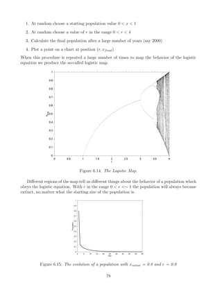
The dangers of extrapolation we put into a geoscience context 125 years ago by Mark Twain
in his memoir Life on the Mississippi (1884):
“In the space of one hundred and seventy six years the Lower Mississippi has shortened it-
self two hundred and forty-two miles. That is an average of a trifle over a mile and a third per
year. Therefore, any calm person, who is not blind or idiotic, can see that in the Old Olitic
Silurian Period, just a million years ago next November, the Lower Mississippi was upwards
of one million three hundred thousand miles long, and stuck out over the Gulf of Mexico like a
fishing-pole. And by the same token any person can see that seven hundred and forty-two years
from now the Lower Mississippi will be only a mile and three-quarters long, and Cairo [Illinois]
and New Orleans will have joined their streets together and be plodding comfortably along under
a single mayor and a mutual board of aldermen. There is something fascinating about science.
One gets such wholesale returns of conjecture out of such a trifling investment of fact.”
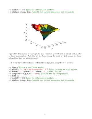
8.3 Interpolation in two dimensions
The ideas of interpolation in one-dimension can be extended into higher dimensions. MATLAB
has a number of inbuilt functions for interpolation in two or more dimensions, but the one most
suitable for most purposes is griddata which fits a grided surface to a collection of data points
(basically the same task as performed in the software package GRAPHER). As before there are
a number of different methods to perform the interpolations, simple ones such as “linear” and
99](https://image.slidesharecdn.com/anintroductiontomatlabforgeoscientists-231208112439-be4fa83c/85/An-Introduction-to-MATLAB-for-Geoscientists-pdf-100-320.jpg)
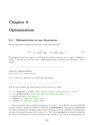
![“nearest neighbor” and more complex ones, such as “cubic” and “v4” which allow the surface
to be curved between the data points. To demonstrate the use of griddata we are going to
load some topographic measurements, plot them as points in three-dimensions and fit different
surfaces to them. Our data has to be interpolated on to regular grids, this can be done using
the meshgrid function.
>> load topo %data containing the variables x, y, z
>> figure %create a new figure window
>> plot3(x,y,z,'ok','markerfacecolor','k') %plot the data as black points
>> xlabel('x'), ylabel('y'), zlabel('z') %label the axes
420
430
440
450
460
470
60
80
100
120
−30
−20
−10
0
10
20
x
y
z
Figure 8.8: Topographic raw data plotted as a collection of points. If you would like to explore
the structure of the data you can use the “Rotate3D” button in the figure window.
Now we must create the regular grids onto which the data will be interpolated. This is done
by defining vectors in the x and y directions and bringing them together using the function
meshgrid.
>> x0=[420:0.25:470]; %define x-locations for grid (201 points)
>> y0=[70:0.25:120]; %define y-locations for grid (201 points)
>> [XI,YI]=meshgrid(x0,y0); %generate x,y grids (201 x 201 points)
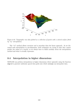
Once the grids are prepared the interpolation can be performed and the results plotted. The
first three inputs for griddata are the x, y, z coordinates of the raw data, the next to inputs
are the XI and YI grids onto which the data will be interpolated, and the final input is a string
defining the interpolation method. First we’ll use linear interpolation:
>> ZI=griddata(x,y,z,XI,YI,'linear'); %perform the linear interpolation
>> hold on
100](https://image.slidesharecdn.com/anintroductiontomatlabforgeoscientists-231208112439-be4fa83c/85/An-Introduction-to-MATLAB-for-Geoscientists-pdf-101-320.jpg)
![-1 -0.5 0 0.5 1 1.5 2
-120
-100
-80
-60
-40
-20
0
x
y
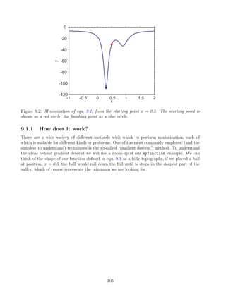
Figure 9.1: Evaluation of equ. 9.1 in the range [-1,2].
this case we will minimize myfunction with a starting value of x = 0.5
>> x0 = fminsearch(@(x) myfunction(x), 0.5)
x0 =
0.3004
The returned value tell us that within a predefined tolerance equ. 9.1 reaches its minimum
value at x = 0.3004. We can add this information to the plot:
>> hold on
>> plot(0.5,myfunction(0.5),'or') % add a red maker at the starting point
>> plot(x0,myfunction(x0),'ob') % add a blue maker at the minimum
In order to minimize equ. 9.1 we wrote a separate function, however, if your expression is
relatively simple you can also use an inline function:
>> f = inline('-1./((x-0.3).∧
2+0.01)-1./((x-0.9).∧
2+0.04)-6')
>> x0 = fminsearch(@(x) f(x), 0.5)
x0 =
0.3004
104](https://image.slidesharecdn.com/anintroductiontomatlabforgeoscientists-231208112439-be4fa83c/85/An-Introduction-to-MATLAB-for-Geoscientists-pdf-105-320.jpg)
![y.
z = f(x, y) =3(1 − x)2
exp(−x2
− (y + 1)2
)
− 1
x
5
− x3
− y5
exp(−x2
− y2
)
−
1
3
exp(−(x + 1)2
− y2
)
(9.2)
This is probably a bit too complicated to write as a single inline function, so again we will write
a separate m-function file, but we have to take into account the manner in which fminsearch
works. The fminsearch function only allows one variable to be changed during the minimiza-
tion, therefore we must input x and y together as a single variable. The easiest way to do this
is to combine x and y for the call to the function, but then split them once they are inside the
function. Therefore we’ll use one input variable xy, the first column of which is the x data and
the second column of which is the y data.
function z=myfunction2(xy)
%function to calculate equ. 9.2
%to make things easier we’ll split the calculation into 3 parts
x=xy(:,1); y=xy(:,2) split the data into its x and y components
A=3.*(1-x).∧
2.*exp(-x.∧
2-(y+1).∧
2);
B=-10.*(x./5-x.∧
3-y.∧
5).*exp(-x.∧
2-y.∧
2);
C=-1./3.*exp(-(x+1).∧
2-y.∧
2);
z = A + B + C;
First we should look at the shape of the function, to act as an input we need matrices rep-
resenting x,y. To do this we can use the meshgrid function that we used previously:
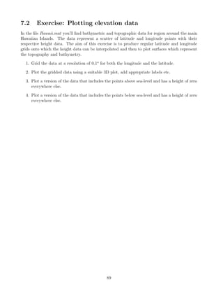
[x,y]=meshgrid(-3:0.1:3,-3:0.1:3); %generate the (x,y) data
z = myfunction2([x(:),y(:)]); % combine x and y, and determine the value
surfc(x,y,z) %plot as a surface with contour lines
colormap gray %use the grayscale color map
xlabel('x') %add a label to the x-axis
ylabel('y') %add a label to the y-axis
zlabel('z') %add a label to the z-axis
109](https://image.slidesharecdn.com/anintroductiontomatlabforgeoscientists-231208112439-be4fa83c/85/An-Introduction-to-MATLAB-for-Geoscientists-pdf-110-320.jpg)
![−2
0
2
−2
0
2
−10
−5
0
5
10
x
y
z
Figure 9.6: The two-dimensional function defined by equ. 9.2. Use the Rotate3D option to
examine the topography, you should see that there are three minima; two local and one global.
We can locate the minima in equ. 9.2 using fminsearch in the same manner as we did for
the one-dimensional case. The only difference is that because we are now working with x and y
coordinates we need to supply a first guess for each one (entered into function as a single array).
Lets start with an initial guess of (1.1,-0.6):
hold on
xy0 = fminsearch(@(xy) myfunction2(xy),[1.1,-0.6])
plot3(1.1,-0.6,myfunction2([1.1 -0.6]),'or') %plot the starting point
plot3(xy0(1),xy0(2),myfunction2(xy0),'ob') %plot the finishing point
−3 −2 −1 0 1 2 3
−2
0
2
−10
−5
0
5
10
x
y
z
Figure 9.7: Minimization of equ. 9.2, using fminsearch from a starting point of (1.1,-0.6). The
starting point is shown as a red circle, the finishing point as a green circle.
As with the one-dimensional case, fminsearch will work downhill towards a minimum, which
may not necessarily be the global minimum.
110](https://image.slidesharecdn.com/anintroductiontomatlabforgeoscientists-231208112439-be4fa83c/85/An-Introduction-to-MATLAB-for-Geoscientists-pdf-111-320.jpg)
![The one and two-dimensional cases that we have examined so far have been very simply where
you could minimize the function quite accurately by eye. Now we will look at more complicated
situations where the power of optimization will hopefully become evident.
9.3 Constrained Optimization
In many cases it is desirable to force our minimization problem to fit certain constraints. For
example, we may fit a curve to data and know from theory that it should be constrained to have
a certain form. Lets start with a curve fitting problem of this form, imagine we are studying a
data set with the which follows the cubic relationship:
f(x) = c1x3
+ c2x2
+ c3x + c4 (9.3)
Now we’ll simulate some experimental data that follows this relationship. To do this we will
calculate the values of the function for different values of x and add some random numbers to
the results to simulate experimental noise.
coef = [1 -2 1 -1]; %coefficients of the cubic curve
x = linspace(-2,4,100); %an array of 100 x values between -2 and 4
y = coef(1).*x.∧
3 + coef(2).*x.∧
2 + coef(3).*x + coef(4); %calculate the curve
y = y + randn(size(y)); % add random numbers to the curve to act as noise
plot(x,y,'.b') %plot the synthetic data as blue points
-2 -1 0 1 2 3 4
-30
-20
-10
0
10
20
30
40
x
y
Figure 9.8: Simulated experimental data following the relationship given in equ. 9.3. Your data
may not look exactly the same because the random numbers used to represent the noise will be
different.
111](https://image.slidesharecdn.com/anintroductiontomatlabforgeoscientists-231208112439-be4fa83c/85/An-Introduction-to-MATLAB-for-Geoscientists-pdf-112-320.jpg)
![We can use minimize the “sum of squared residuals” to find the best fit to the data. In this
case we will fit a cubic polynomial to the data, but of course we won’t get a perfect fit because
we have added a noise component. First we need to calculate the value of the line for a given
set of coefficients (which we will store in the vector, c) and then determine the difference to the
data, i.e. determine the residuals.
function ssr = objfun(c,xdata,ydata)
%objective function to calculate residuals on a cubic fit
%calculate the line given the coefficients in c
yhat=c(1).*xdata.∧
3 + c(2).*xdata.∧
2 + c(3).*xdata + c(4);
%calculate the sum of the squared residuals by comparing to ydata
ssr = sum((ydata-yhat).∧
2);
The optimal fit to the data is found when we minimize the sum of the squared residuals.
We can do this using fminsearch, with a starting guess of c of all zeros. When we have the
optimized version of c we can calculate and plot the best fit line for our different values of x.
c = fminsearch(@(c) objfun(c,x,y),[0 0 0 0]) %minimize the residuals
y0 = c(1).*x.∧
3 + c(2).*x.∧
2 + c(3).*x + c(4); %the fitted cubic curve
hold on
plot(x,y0,'r','linewidth',1) %plot the fitted curve as a red line
-2 -1 0 1 2 3 4
-30
-20
-10
0
10
20
30
40
x
y
Figure 9.9: Optimized cubic fit (red line) to the experimental data (blue dots).
The fit seems to be okay, but imagine the situation where theory tells us the fitted curve has
to obey certain constraints. The function fminsearch can only perform unconstrained mini-
mization, so instead we must use the function fmincon, which has addition inputs which allow
you to add problem constraints. The inputs are quite complex, but they allow us to define
linear inequalities, linear equalities and bounds; they are as follows:
112](https://image.slidesharecdn.com/anintroductiontomatlabforgeoscientists-231208112439-be4fa83c/85/An-Introduction-to-MATLAB-for-Geoscientists-pdf-113-320.jpg)
![c = fmincon(function,c0,A,b,Aeq,beq,lb,ub)
minimize f(c) such that:
A · c ≤ b
Aeq · c = beq
lb ≤ c ≤ ub
(9.4)
So what does all of this mean? The constraints allow us to find a solution to the minimization
problem which meet certain requirements. Lets look at the statements one by one, in all cases
the final solution of the minimization is represented by c:
• A · c ≤ b, we can define a set of values in A that when matrix multiplied by c must be less
than or equal to the defined value b.
• Aeq · c ≤ beq, we can define a set of values in A that when matrix multiplied by c must
be equal to the defined value b.
• lb ≤ c ≤ ub, all the values in c must be greater than or equal to the lower bound, lb, and
less than or equal to the upper bound, ub.
9.3.1 Linear Equalities
We’ll start by enforcing a constraint that the curve must pass through the point (-2,-19). To
do this we must use the linear equalities option, which can be written in the form:
A = [−23
, −22
, −2, 1]
A · c = −19
In MATLAB notation we can set the constraints and call the function in the following way:
xc = -2 %define the constrained x value
yc = -19 %define the constrained y value
Aeq=xc.∧
[3,2,1,0]; %left-hand side of the constraint
beq=yc; %right-hand side of the constraint
c=fmincon(@(c) objfun(c,x,y),[0 0 0 0],[],[],Aeq,beq,[],[]); %call fmincon
y0 = c(1).*x.∧
3 + c(2).*x.∧
2 + c(3).*x + c(4); %the fitted cubic curve
plot(x,y0,'k','linewidth',1) %plot the fitted curve as a black line
113](https://image.slidesharecdn.com/anintroductiontomatlabforgeoscientists-231208112439-be4fa83c/85/An-Introduction-to-MATLAB-for-Geoscientists-pdf-114-320.jpg)
![-2 -1 0 1 2 3 4
-30
-20
-10
0
10
20
30
40
x
y
Figure 9.10: Optimized cubic fit (black line) to the experimental data (blue dots) constrained to
pass through the point (-2,-19).
We can look at the returned coefficients in c, and check that Aeq · c does in fact equal beq.
c'%display the coefficients as a column
ans =
1.0281
-2.0414
0.8203
-0.9689
Aeq*c'%check the equality constraint
ans =
-19
To add more equality constraints is simple, we just need to combine them into a matrix with
one for each constraint. We have our first constraint that the fitted line must pass through the
point (-2,-19), now lets add another constraint to also force the line through (0,-1):
Aeq(1,:)=(-2).∧
[3,2,1,0]; %left-hand side of the 1st constraint
beq(1,1)=-19; %right-hand side of the 1st constraint
Aeq(2,:)=0.∧
[3,2,1,0]; %left-hand side of the 2nd constraint
beq(2,1)=-1; %right-hand side of the 2nd constraint
c=fmincon(@(c) objfun(c,x,y),[0 0 0 0],[],[],Aeq,beq,[],[]); %call fmincon
y2 = c(1).*x.∧
3 + c(2).*x.∧
2 + c(3).*x + c(4); %the fitted cubic curve
plot(x,y2,'g','linewidth',1) %plot the fitted curve as a green line
Aeq*c'%check the inequality constraint
ans =
114](https://image.slidesharecdn.com/anintroductiontomatlabforgeoscientists-231208112439-be4fa83c/85/An-Introduction-to-MATLAB-for-Geoscientists-pdf-115-320.jpg)
![-19.0000
-1.0000
-2 -1 0 1 2 3 4
-30
-20
-10
0
10
20
30
40
x
y
Figure 9.11: Optimized cubic fit (green line) to the experimental data (blue dots) constrained to
pass through the points (-2,-19) and (0,-1).
9.3.2 Linear inequalities
Now lets try a linear inequality, forcing the fitted curve to have a gradient greater than or equal
to 5 when x = 2. First we need an expression for the gradient of the cubic polynomial, a bit of
simple calculus gives us:
f0
(x) = 3c1x2
+ 2c2x + c3 (9.5)
We can now write the constrain on the gradient based on equ. 9.5:
x1=2
y1=5
A=[3.*x1.∧
2, 2.*x1, 1, 0]
b=y1
Before we call the function it is important to note that our constraint demands that the gradient
is greater than or equal to a given value, whilst the function uses linear inequalities of the form
less than or equal to. We can get around this problem very simply by using −A and −b as the
constraints, also keeping our previous linear equality the function call looks like:
c=fmincon(@(c) objfun(c,x,y),[0 0 0 0],-A,-b,Aeq,beq,[],[]);
We can check that the inequality constraint is met and then plot the resulting line:
115](https://image.slidesharecdn.com/anintroductiontomatlabforgeoscientists-231208112439-be4fa83c/85/An-Introduction-to-MATLAB-for-Geoscientists-pdf-116-320.jpg)
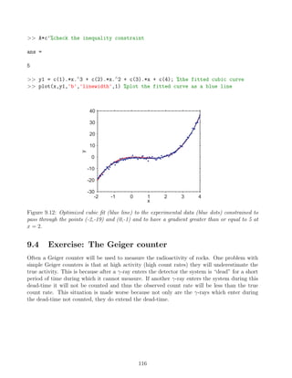
![• [255,0,0] → red
• [0,255,0] → green
• [0,0,255] → blue
• [255,255,255] → white
• [0,0,0] → black
• [127,255,212] → aquamarine
Later when we start loading images into MATLAB we will see how the information on the
different colour channels is stored. The other important colour model for us to consider is
“grayscale” which only carries intensity information, representing a mixture of black and white.
As with the RGB model, grayscale normally ranges between 0 (black) and 1 or 255 (white),
therefore for each pixel we only need to store one unsigned 8-bit integer.
10.1 MATLAB and images
A number of M-functions are available in the standard release of MATLAB with which to read,
display and save images. In this first example we will recover information about an image, then
load it and look how it is structured before finally displaying it. Over the following examples
there will be a number of repeated commands, so it would be a good idea to produce a script
function from which you can easily recall certain tasks. We will clear the memory and close all
existing figures before using the function imfinfo to obtain information on the properties of
the image file thin section1.jpg.
clear all, close all
info=imfinfo('thin section1.jpg')
info =
Filename: 'C:Documents and Settingsthin section1.jpg'
FileModDate: '08-Oct-2009 16:45:58'
FileSize: 413876
Format: 'jpg'
FormatVersion: ''
Width: 640
Height: 449
BitDepth: 24
ColorType: 'truecolor'
FormatSignature: ''
119](https://image.slidesharecdn.com/anintroductiontomatlabforgeoscientists-231208112439-be4fa83c/85/An-Introduction-to-MATLAB-for-Geoscientists-pdf-120-320.jpg)
![NumberOfSamples: 3
CodingMethod: 'Huffman'
CodingProcess: 'Sequential'
Comment: {}
As you can see this provides us with detailed information concerning the properties of the
image. We can load the image into the memory using the imread function and we will store the
numeric data representing the pixel colors in an array called I. We will then look at the size
of I to understand how the data is organized:
I = imread('thin section1.jpg');
size(I)
ans =
449 640 3
The size information reveals that we have a three-dimensional matrix, in the third dimension
we have 3 layers of data. You can think of this structure as a collection of 3 two-dimensional
matrices which are 449 by 640 lying on top of each other. The different layers represent the
different color channels in the sequence; red (first layer), green (second layer) and blue (third
layer). So if we wanted to look at the RGB values for the first pixel in the image (top lefthand
corner) we can simply call it by its index:
I(1,1,:)
ans(:,:,1) =
2
ans(:,:,2) =
2
ans(:,:,3) =
12
which means it has an RGB triplet of [2,2,12]. Finally, we are going to display the im-
age using the function imagesc, once this is plotted we need to adjust the aspect ratio of the
image to ensure the pixels are square (by default MATLAB plots with an xy aspect ratio cor-
respond to the golden section so in the case of images we need to adjust this ratio). As a last
step we will remove the plot axes which are included in the figure by default:
imagesc(I) %diplay image
set(gca,'dataaspectratio',[1 1 1]) %equal xy scaling
set(gca,'visible','off') %remove axes
120](https://image.slidesharecdn.com/anintroductiontomatlabforgeoscientists-231208112439-be4fa83c/85/An-Introduction-to-MATLAB-for-Geoscientists-pdf-121-320.jpg)
![Figure 10.1: The RGB image stored in the file thin section1.jpg.
10.2 Intensity information and Colormaps
One important operation is to be able to convert an image from the RGB color model in the
gray scale color model. This is actually surprisingly easy, all it requires is for us to convert
the RGB triplets into intensity information using a bit of book-keeping (making sure all the
information is stored in the right places) and a matrix multiplication with some predefined
transfer coefficients. We’ll plot the final result and then also look at how we can change the
appearance using MATLAB’s various colormaps. To start with we’ll clear the memory and
reload the original image.
clear all, close all
I = imread('thin section1.jpg'); %load image as 3D RGB array
We’re now going to separate the three-dimensional matrix into a collection of three two-
dimensional matrices, one for each color channel. This means extracting each layer and using
the squeeze function to reduce it from a 3D 449 by 640 by 1 matrix to a 2D 449 by 640 matrix
(as you might of guessed the squeeze function removes singleton dimensions).
R=squeeze(I(:,:,1)); %obtain a 2D copy of red channel information
G=squeeze(I(:,:,2)); %obtain a 2D copy of green channel information
B=squeeze(I(:,:,3)); %obtain a 2D copy of blue channel information
We’ll now recombine the color information in the form of 3 vectors; red, green and blue which
each contains 287360 entries (i.e. the product of 449 and 640) and convert the numbers to
double precision.
RGB=[R(:),G(:),B(:)]; %form RGB into a 3 column matrix
RGB=double(RGB); %convert to double precision
In order to derive the intensity values we now perform a matrix multiplication between the
matrix RGB and some predefined coefficients and then check that no values lie outside the
allowable 0 to 255 range. Once this done we simply need to reorganize the pixels into their
121](https://image.slidesharecdn.com/anintroductiontomatlabforgeoscientists-231208112439-be4fa83c/85/An-Introduction-to-MATLAB-for-Geoscientists-pdf-122-320.jpg)
![original positions thus restoring the structure of the image.
coef=[0.2989; 0.5870; 0.1140] %RGB to intensity transform
GS=RGB*coef; %(matrix) multiply RGB and transform coefficients
GS(GS0)=0; %round up values below 0
GS(GS255)=255; %round down values above 255
[r,c]=size(I(:,:,1)) %rows and columns of original image
GS=reshape(GS,[r c]); %change from a vector to a matrix
We now have a two-dimensional matrix which has the same size and shape as the original
image and contains individual intensity values for each of the pixels. We can plot this intensity
information using the imagesc function and then change its appearance using various colormaps
(a grayscale color model is the most traditional for this kind of data).
imagesc(GS) %diplay intensities with default jet colormap
set(gca,'dataaspectratio',[1 1 1]) %set equal x y scaling
set(gca,'visible','off') %remove axes
colormap gray(256) %change colormap to gray with 256 levels
colormap cool(256) %change colormap to cool with 256 levels
colormap summer(256) %change colormap to summer with 256 levels
Finally, if we can output the image using the function imwrite which has additional argu-
ments to control the type of image, level of compression etc (see the help entry of imwrite for
more information).
imwrite(GS,summer(256),'test.jpg','quality',90) %output image as jpg
Figure 10.2: The intensity image displayed with a variety of different colormaps
122](https://image.slidesharecdn.com/anintroductiontomatlabforgeoscientists-231208112439-be4fa83c/85/An-Introduction-to-MATLAB-for-Geoscientists-pdf-123-320.jpg)
![10.3 Cropping an image
Cropping images is a simple task of identifying the outmost pixels of the region of interest and
producing a copy of the image data up to these boundaries. In the following example we study
how to crop an intensity image and then extend the idea to RGB images. We’ll also define the
limits of the region of interest by interacting with the image directly using the ginput function.
Notice the must of the first part of this exercise is a repeat of previous exercises (loading the
image, converting it to intensity values etc), but it is still included for completeness.
clear all, close all
I = imread('thin section1.jpg'); %load image as 3D RGB array
R=squeeze(I(:,:,1)); %obtain copy of red channel information
G=squeeze(I(:,:,2)); %obtain copy of green channel information
B=squeeze(I(:,:,3)); %obtain copy of blue channel information
RGB=[R(:),G(:),B(:)]; %form RGB into a 3 column matrix
RGB=double(RGB); %convert to double precision
coef=[0.2989; 0.5870; 0.1140] %RGB to intensity transform
GS=RGB*coef; %(matrix) multiply RGB and transform coefficiants
GS(GS0)=0; %round up values below 0
GS(GS255)=255; %round down values above 255
[r,c]=size(I(:,:,1)) %rows and columns of original image
GS=reshape(GS,[r c]); %change from a vector to a matrix
imagesc(GS) %diplay intensities with default jet colormap
set(gca,'dataaspectratio',[1 1 1]) %set equal x y scaling
set(gca,'visible','off') %remove axes
colormap gray(256) %change colormap to gray with 256 levels
At this stage we have loaded the image, converted it to magnitude data and displayed the
results. Next we’ll use the ginput function to display the select the region on interest. When
used in the form ginput(n) the function will bring the active image to the front and using a set
of cross-hairs allow use to define n positions with a click of the mouse. The x and y positions of
these locations will be stored in the output variables. In this case we need to define two posi-
tions which are the opposite corners of the region of interest. Because we will employ the x and
y values as addresses they must be rounded to the nearest integer (using the round function)
and then we will make a copy of the intensity data between these limits. Notice the use of the
min and max functions when defining the addresses, this is necessary because we don’t know in
which order the user selected the corner points.
[xlim,ylim]=ginput(2) %interact with image to define 2 corner points
xlim=round(xlim); %round x to nearest integer (i.e. to nearest pixel)
ylim=round(ylim); %round y to nearest integer (i.e. to nearest pixel)
GSc=GS(min(ylim):max(ylim),min(xlim):max(xlim)); %select rows and columns
123](https://image.slidesharecdn.com/anintroductiontomatlabforgeoscientists-231208112439-be4fa83c/85/An-Introduction-to-MATLAB-for-Geoscientists-pdf-124-320.jpg)
![The cropped version of GS now resides in the variable GSc, which can be plotted
in the same manner as other intensity images:
figure %create new figure window
imagesc(GSc) %diplay cropped image
set(gca,'dataaspectratio',[1 1 1]) %set equal x y scaling
set(gca,'visible','off') %remove axes
colormap gray(256) %change colormap to gray with 256 levels
Figure 10.3: Cropped intensity image displayed with a grayscale colormap
10.4 Cropping a colour image
The ideas behind cropping colour images are exactly the same as intensity images. The key
difference is that now we are working with a three rather than two dimensional matrix and we
must crop each of the red, green and blue layers appropriately. The first part of this is example
follows the ideas introduced above, load the image, display it and select the crop points using
the ginput function.
clear all, close all
I = imread('thin section1.jpg'); %load image as 3D RGB array
imagesc(I) %display image
set(gca,'dataaspectratio',[1 1 1]) %set equal x y scaling
set(gca,'visible','off') %remove axes
[xlim,ylim]=ginput(2) %interact with image to define 2 crop points
xlim=round(xlim); %round x to nearest integer (i.e. to nearest pixel)
ylim=round(ylim); %round y to nearest integer (i.e. to nearest pixel)
We can now use the limits in xlim and ylim to act as addresses to crop the image across
all three layers.
%now select rows and columns of the ROI and all 3 color layers
Ic=I(min(ylim):max(ylim),min(xlim):max(xlim),:);
124](https://image.slidesharecdn.com/anintroductiontomatlabforgeoscientists-231208112439-be4fa83c/85/An-Introduction-to-MATLAB-for-Geoscientists-pdf-125-320.jpg)
![figure %create new figure window
imagesc(Ic) %diplay cropped RGB image
set(gca,'dataaspectratio',[1 1 1]) %set equal x y scaling
set(gca,'visible','off') %remove axes
If we want to output this image using imwrite there are two important differences to the
intensity example we looked at earlier. The first is the data must be converted from double
precision into unsigned 8-bit integers, this can be achieved with the command:
Ic=uint8(Ic);
Secondly when we give the imwrite command we do not need to define a colormap because we
are providing a collection of RGB values (i.e. the colors are defined by the data itself).
imwrite(Ic,'test.jpg','quality',90)
Figure 10.4: Cropped RGB image
10.5 Resizing and Aspect ratios
In this example we will work with an intensity image, but exactly the same procedure could
be applied to an RGB image by processing the individual red, green and blue layers separate
two-dimensional matrices and then recombining them into a three-dimensional matrix. To begin
with we will load the image and convert it into intensity data (using the same commands as
above):
clear all, close all
I = imread('thin section1.jpg'); %load image as 3D RGB array
R=squeeze(I(:,:,1)); %obtain copy of red channel information
G=squeeze(I(:,:,2)); %obtain copy of green channel information
B=squeeze(I(:,:,3)); %obtain copy of blue channel information
RGB=[R(:),G(:),B(:)]; %form RGB into a 3 column matrix
RGB=double(RGB); %convert to double precision
125](https://image.slidesharecdn.com/anintroductiontomatlabforgeoscientists-231208112439-be4fa83c/85/An-Introduction-to-MATLAB-for-Geoscientists-pdf-126-320.jpg)
![coef=[0.2989; 0.5870; 0.1140] %RGB to intensity transform
GS=RGB*coef; %(matrix) multiply RGB and transform coefficiants
GS(GS0)=0; %round up values below 0
GS(GS255)=255; %round down values above 255
[r,c]=size(I(:,:,1)) %rows and columns of original image
GS=reshape(GS,[r c]); %change from a vector to a matrix
imagesc(GS) %diplay intensities with default jet colormap
set(gca,'dataaspectratio',[1 1 1]) %set equal x y scaling
set(gca,'visible','off') %remove axes
colormap gray(256) %change colormap to gray with 256 levels
To consider the problems of resizing and adjusting aspect ratios it is important to think about
how the image data is organized. We have a series of square pixels positioned on a regu-
larly spaced grid, which in this specific case has 449 rows and 640 columns. We can generate
appropriately spatial grids representing the positions using the meshgrid function and assum-
ing the upper-left pixel has a position of [0,0] and the lower-right pixel has a position of [1,1].
% make x and y grids to represent pixel positions
[x,y]=meshgrid(linspace(0,1,size(GS,2)),linspace(0,1,size(GS,1)));
The next step is to define factors in the by which to contract or expand the figure in both
the x and y directions (where values greater than 1 represent expansion and those less than 1
represent contraction).
xf=2.0 %reduce resolution in x axis by 50%
yf=0.5 %increase resolution in x axis by 275%
Now we’ll make two new spatial grids (xn and yn) which again range between [0,0] and
[1,1] but have the increments between points in the x and y directions adjusted by the prede-
fined factors. This means were we want to expand the image we will include more points and
alternatively where we want to contract the image we will include less points. Once these grids
are produced we simply need to interpolate the image data from the original x and y grids onto
the new xn and yn grids.
%change resolution in x and y directions by given factors
[xn,yn]=meshgrid(linspace(0,1,size(GS,2).*xf),linspace(0,1,size(GS,1).*yf));
GSs=griddata(x,y,GS,xn,yn); %interpolate image on to new grid points
Because the spatial information of the image is inherent to the structure of the data (as men-
tioned above, pixels are square and assumed to be equally spaced in the x and y directions)
we have now expanded and compressed the image by adding and removing pixels, respectively.
The last step is to display the rescaled image.
figure %create new figure window
126](https://image.slidesharecdn.com/anintroductiontomatlabforgeoscientists-231208112439-be4fa83c/85/An-Introduction-to-MATLAB-for-Geoscientists-pdf-127-320.jpg)
![imagesc(GSs) %diplay cropped image
set(gca,'dataaspectratio',[1 1 1]) %set equal x y scaling
set(gca,'visible','off') %remove axes
colormap gray(256) %change colormap to gray with 256 levels
Figure 10.5: Intensity image expanded to 200% in the x direction and shrunk to 50% in the y
direction
10.6 Image Rotation
Rotating an image follows the same ideas as the previous example, we manipulate the original
positions of the pixels and then interpolate onto a regular grid. In this example we will look at
an RGB image, so the 3 layers will need to be treated separately. The first task is to load the
image and display it.
clear all, close all
I = imread('thin section1.jpg'); %load image as 3D RGB array
imagesc(I) %diplay image
set(gca,'dataaspectratio',[1 1 1]) %set equal x y scaling
set(gca,'visible','off') %remove axes
Next we will define the angle (in radians) we would like to rotate the image through and
use this to define a two-dimensional rotation matrix of the form:
cos θ − sin θ
sin θ cos θ
In code this looks like:
phi=45./180.*pi; %choose rotation angle and convert to radians
T=[cos(phi) -sin(phi); sin(phi) cos(phi)]; %2D rotation matrix
To perform the rotation we need to define a set of pseudo x,y positions for the pixels. An
important point to consider here is that the rotation matrix we have constructed will rotate
about the point (0, 0), therefore if we want to rotate the image about its center our grids of
positions must range between an upper-left position of [-0.5,-0.5] and a lower-right position
of [0.5,0.5].
[r,c,l]=size(I) %image size (rows, columns, layers)
127](https://image.slidesharecdn.com/anintroductiontomatlabforgeoscientists-231208112439-be4fa83c/85/An-Introduction-to-MATLAB-for-Geoscientists-pdf-128-320.jpg)
![%generate pseudo x,y positions for each of the pixels
[x,y]=meshgrid(linspace(-0.5,0.5,c),linspace(-0.5,0.5,r));
Now we can form the x and y pixel positions into column vectors and combine them into a
matrix. To rotate the positions we simply perform a matrix multiplication with the rotation
matrix.
xy=[x(:),y(:)]; %set positions as vectors and combine into a matrix
xyT=xy*T; %(matrix) multiply position and rotation matrix
xT=xyT(:,1) %rotated x positions
yT=xyT(:,2) %rotated y positions
We now have a rotated position associated with each of the pixels in the original image, this
means that we can take the values for the red, green and blue layers and interpolate them from
the rotated coordinates back onto regular coordinate grids which span the range of the rotated
coordinates, thus completing the rotation.
R=squeeze(I(:,:,1)); %obtain copy of red channel information
G=squeeze(I(:,:,2)); %obtain copy of green channel information
B=squeeze(I(:,:,3)); %obtain copy of blue channel information
RGB=[R(:),G(:),B(:)]; %form RGB into a 3 column matrix
RGB=double(RGB); %convert to double precision
[x,y]=meshgrid(linspace(min(xT),max(xT),c),linspace(min(yT),max(yT),r));
Rr=griddata(xT,yT,RGB(:,1),x,y); %interpolate red on regular grid
Gr=griddata(xT,yT,RGB(:,2),x,y); %interpolate green on regular grid
Br=griddata(xT,yT,RGB(:,3),x,y); %interpolate blue on regular grid
We now need to need to reorganize the data into a three-dimensional matrix and the con-
vert it into unsigned 8-bit integers:
%create a copy of I into which the rotated data will be placed
Ir=double(I);
Ir(:,:,1)=Rr;
Ir(:,:,2)=Gr;
Ir(:,:,3)=Br;
Ir=uint8(Ir) %convert data into unsigned 8bit integers
Finally we can display the image, note the now empty black areas where no image informa-
tion exists.
figure %create new figure window
imagesc(Ir) %diplay image
set(gca,'dataaspectratio',[1 1 1]) %set equal x y scaling
set(gca,'visible','off') %remove axes
128](https://image.slidesharecdn.com/anintroductiontomatlabforgeoscientists-231208112439-be4fa83c/85/An-Introduction-to-MATLAB-for-Geoscientists-pdf-129-320.jpg)
![Figure 10.6: RGB image rotated by 45o
10.7 Histogram Equalization
Histogram equalization provides a method with which to adjust (enhance) the contrast of an
image. This is achieved by flattening and stretching the distribution of pixel intensities across
the range 0 to 255. In the following example we will load our standard image, convert it to
intensities and produce a histogram of the resulting values.
clear all, close all
I = imread('thin section1.jpg'); %load image as 3D RGB array
R=squeeze(I(:,:,1)); %obtain copy of red channel information
G=squeeze(I(:,:,2)); %obtain copy of green channel information
B=squeeze(I(:,:,3)); %obtain copy of blue channel information
RGB=[R(:),G(:),B(:)]; %form RGB into a 3 column matrix
RGB=double(RGB); %convert to double precision
coef=[0.2989; 0.5870; 0.1140] %RGB to intensity transform
GS=RGB*coef; %(matrix) multiply RGB and transform coefficiants
GS(GS0)=0; %round up values below 0
GS(GS255)=255; %round down values above 255
[r,c]=size(I(:,:,1)) %rows and columns of original image
GS=reshape(GS,[r c]); %change from a vector to a matrix
imagesc(GS) %diplay intensities with default jet colormap
set(gca,'dataaspectratio',[1 1 1]) %set equal x y scaling
set(gca,'visible','off') %remove axes
colormap gray(256) %change colormap to gray with 256 levels
129](https://image.slidesharecdn.com/anintroductiontomatlabforgeoscientists-231208112439-be4fa83c/85/An-Introduction-to-MATLAB-for-Geoscientists-pdf-130-320.jpg)
![At this stage we would like to produce a histogram of the intensity values. This can be achieved
using the hist function to count the number of pixels falling into defined bins and the bar
function to plot the result.
N = histc(GS(:),[0:255]); %find number of pixels in each intensity band
figure, bar([0:255],N,'histc') %plot histogram
xlabel('Intensity [0-255]') %add a x-label
ylabel('Number of Pixels') %add a y-label
set(gca,'tickdir','out') %make ticks face outwards
0 50 100 150 200 250 300
0
2000
4000
6000
8000
10000
12000
14000
Intensity [0−255]
Number
of
Pixels
Figure 10.7: Histogram of pixel intensities
We can see that the distribution of intensities is strongly skewed towards darker values,
in this case we may be able to improve the image contrast by flattening the distribution to
give a more uniform spread of intensities. As a first step we will find the empirical cumulative
probability distribution of the number of pixels in each of the intensities bands. This is sim-
ple given that we have already determined N which is the number of pixels in each intensity band.
Nc=cumsum(N)./sum(N); %cumulative sum of number of pixels from 0 to 255
We now have enough information to be able to transform (via interpolation) from intensi-
ties values into cumulative probabilities which will lie within the range 0 and 1. We can then
normalize distribution to have extremes of 0 and 1 and multiply by 255 to the values span the
full range of possible intensities.
Jc=interp1([0:255],Nc,GS); %interpolate pixel intensity onto the cdf
Jc=Jc-min(Jc(:)); %normalize lowest value to zero
Jc=Jc./max(Jc(:)); %normalize largest value to 1
Jc=round(Jc*255); %set data in full range [0-255]
130](https://image.slidesharecdn.com/anintroductiontomatlabforgeoscientists-231208112439-be4fa83c/85/An-Introduction-to-MATLAB-for-Geoscientists-pdf-131-320.jpg)
![The values stored in Jc represent our equalized image. We can look at the histogram of equal-
ized intensities and then display the image.
N = histc(Jc(:),[0:255]); %find number of pixels in each intensity band
figure, bar([0:255],N,'histc') %plot histogram
xlabel('Intensity [0-255]') %add a x-label
ylabel('Number of Pixels') %add a y-label
set(gca,'tickdir','out') %make ticks face outwards
0 50 100 150 200 250 300
0
1000
2000
3000
4000
5000
6000
Intensity [0−255]
Number
of
Pixels
Figure 10.8: Histogram of equalized image intensities
figure, imagesc(Jc) %diplay adjusted image
set(gca,'dataaspectratio',[1 1 1]) %set equal x y scaling
set(gca,'visible','off') %remove axes
colormap gray(256) %change colormap to gray with 256 levels
Figure 10.9: Test image before and after histogram equalization
131](https://image.slidesharecdn.com/anintroductiontomatlabforgeoscientists-231208112439-be4fa83c/85/An-Introduction-to-MATLAB-for-Geoscientists-pdf-132-320.jpg)
![10.8 Blurring
It might seem a strange idea but some image processing methods work better if an image is
slightly out of focus, a technique known as blurring. We’ll return to this idea later, but for
the time being we will look at a basic method with which we can blur images called Gaussian
Blurring. The idea is simple enough, we construct a two-dimensional Gaussian function and
convolve it with the image in order that the intensity of pixels are replaced with a weighted
average of the their own intensity of the intensity of their neighbors (within a specific spatial
extent). This is analogous to forming a weighted moving average of the pixel intensities in both
the vertical and horizontal directions. In a similar manner to the moving average, the wider the
Gaussian function we construct the more smoothing (blurring) will occur. As with our previous
exercises we’ll start by loading the image data and convert the RGB pixels into intensities.
clear all, close all
I = imread('thin section1.jpg'); %load image as 3D RGB array
R=squeeze(I(:,:,1)); %obtain copy of red channel information
G=squeeze(I(:,:,2)); %obtain copy of green channel information
B=squeeze(I(:,:,3)); %obtain copy of blue channel information
RGB=[R(:),G(:),B(:)]; %form RGB into a 3 column matrix
RGB=double(RGB); %convert to double precision
coef=[0.2989; 0.5870; 0.1140] %RGB to intensity transform
GS=RGB*coef; %(matrix) multiply RGB and transform coefficiants
GS(GS0)=0; %round up values below 0
GS(GS255)=255; %round down values above 255
[r,c]=size(I(:,:,1)) %rows and columns of original image
GS=reshape(GS,[r c]); %change from a vector to a matrix
imagesc(GS) %diplay intensities with default jet colormap
set(gca,'dataaspectratio',[1 1 1]) %set equal x y scaling
set(gca,'visible','off') %remove axes
colormap gray(256) %change colormap to gray with 256 levels
Now we’ll construct the Gaussian function with which to perform the smoothing. First the
width (standard deviation) of the function should be defined, this controls the extent of the
blurring because a wider function will average over a larger area of the image for any given
pixel. To make things simpler we’ll always set the width (assigned as sigma) to a positive
integer. We’ll then evaluate the Gaussian function on a regular grid which spans -3*sigma to
3*sigma in both the x and y directions. Once the function is constructed we can visualize it as
a surface.
sigma=2 %standard deviation of the normal distribution
[xf,yf]=meshgrid(-3*sigma:3*sigma,-3*sigma:3*sigma); %xy grid for filter
g=exp(-(xf.^2+yf.^2)./(2*sigma.^2)); %normal distribution
132](https://image.slidesharecdn.com/anintroductiontomatlabforgeoscientists-231208112439-be4fa83c/85/An-Introduction-to-MATLAB-for-Geoscientists-pdf-133-320.jpg)
![g=g./sum(g(:)); %normalized so the sum of the filter is 1
surf(xf,yf,g) %visualize function as a surface
xlabel('x') %label the x-axis
ylabel('y') %label the x-axis
set(gca,'xlim',[-3*sigma 3*sigma],'ylim',[-3*sigma 3*sigma])
−5
0
5
−5
0
5
0
0.01
0.02
0.03
0.04
x
y
Figure 10.10: Two-dimensional Gaussian function with a standard deviation of 2.
To convolve the function and the intensity data is simple using the inbuilt function conv2
(which performs 2D convolution). We will also use the additional 'valid' which truncates the
final image to remove any edge effects where the function did not sit completely on the image.
We can the plot the blurred intensity data in the standard manner.
GSf=conv2(GS,g,'valid'); %convolve image and filter, remove edge effects
figure %create new figure window
imagesc(GSf) %diplay image
set(gca,'dataaspectratio',[1 1 1]) %set equal x y scaling
set(gca,'visible','off') %remove axes
colormap gray(256) %change colormap to gray with 256 levels
133](https://image.slidesharecdn.com/anintroductiontomatlabforgeoscientists-231208112439-be4fa83c/85/An-Introduction-to-MATLAB-for-Geoscientists-pdf-134-320.jpg)
![Figure 10.11: Image after Gaussian blurring by a function with a standard deviation of 2.
10.9 Edge Detection
As the name suggests the method of edge detection helps us identify possible features in images
by isolating regions where the intensity changes rapidly (i.e. where there could be an edge).
There are a number of advanced techniques for edge detection (for example canny edge detec-
tion) and it is an ongoing field of research. The method we will employ is very simple, detecting
sharp changes in intensity by taking the derivative of the image in both the x and y directions.
Where we find regions with gradients of a large magnitude it is possible that we have detected
an edge. As before we will load out image and transform it into intensity data.
clear all, close all
I = imread('thin section1.jpg'); %load image as 3D RGB array
R=squeeze(I(:,:,1)); %obtain copy of red channel information
G=squeeze(I(:,:,2)); %obtain copy of green channel information
B=squeeze(I(:,:,3)); %obtain copy of blue channel information
RGB=[R(:),G(:),B(:)]; %form RGB into a 3 column matrix
RGB=double(RGB); %convert to double precision
coef=[0.2989; 0.5870; 0.1140] %RGB to intensity transform
GS=RGB*coef; %(matrix) multiply RGB and transform coefficiants
GS(GS0)=0; %round up values below 0
GS(GS255)=255; %round down values above 255
[r,c]=size(I(:,:,1)) %rows and columns of original image
GS=reshape(GS,[r c]); %change from a vector to a matrix
imagesc(GS) %diplay intensities with default jet colormap
set(gca,'dataaspectratio',[1 1 1]) %set equal x y scaling
set(gca,'visible','off') %remove axes
colormap gray(256) %change colormap to gray with 256 levels
As mentioned above to detect possible edges we need to take the gradient of the intensity
134](https://image.slidesharecdn.com/anintroductiontomatlabforgeoscientists-231208112439-be4fa83c/85/An-Introduction-to-MATLAB-for-Geoscientists-pdf-135-320.jpg)
![image in both the x and y directions. MATLAB has a function gradient that will perform
the task for us, returning two outputs Lx and Ly, which are the gradients in the x and y di-
rections, respectively. The magnitude of the gradient is then simply obtained from
p
Lx2 + Ly2.
[Lx,Ly] = gradient(GS) %estimate first-order derivatives in both x and y
d=sqrt(Lx.^2+Ly.^2) %gradient magnitudes
Of course we have a wide distribution of gradients and we need to choose a threshold to define
which values could correspond to real edges. We will perform the this task manual but a number
of more advanced techniques can perform it automatically. To make our choice of a cutoff value,
we will plot the cumulative probability of the gradient magnitudes.
cdfplot(d(:)) %plot cumulative distribution of gradient magnitudes
0 50 100 150 200 250
0
0.1
0.2
0.3
0.4
0.5
0.6
0.7
0.8
0.9
1
x
F(x)
Empirical CDF
Figure 10.12: Cumulative distribution of the gradient magnitudes.
Based on this we will say that only points with a gradient magnitude of 30 or greater will
be considered as edges. Therefore we can take our gradient data and set all the values less than
30 to 0 and all those greater than 30 to 255.
cutoff=30% define cutoff value
dc=d; %copy of gradients to which the cutoff will be applied
dc(dccutoff)=0; %values below cutoff are reduced to zero
dc(dc=cutoff)=255; %values above cutoff are set to maximum
We can now visual the edge data as a black and white image.
figure %create new figure window
imagesc(dc) %display image based on gradients
135](https://image.slidesharecdn.com/anintroductiontomatlabforgeoscientists-231208112439-be4fa83c/85/An-Introduction-to-MATLAB-for-Geoscientists-pdf-136-320.jpg)
![set(gca,'dataaspectratio',[1 1 1]) %set equal x y scaling
set(gca,'visible','off') %remove axes
colormap gray(256) %change colormap to gray with 256 levels
Figure 10.13: Edges (white) defined by a cutoff gradient magnitude of 30.
10.10 Exercise: Improved edge detection
In the previous exercise we performed edge detection on a unprocessed image and got a relatively
messy result without clearly defined edges. There are a number of preprocessing steps that can
help improve the performance of our simple edge detection algorithm. The first is to perform
histogram equalization and the second is to blur the image. The idea behind preprocessing
with blurring is that small scale features which don’t represent true edges will be smoothed out
whilst major features (hopefully true edges) will remain. The task of this exercise is to see how
preprocessing can improve edge detection in either our example image or an image of your own.
You will need to complete the following tasks:
1. Load your image.
2. Convert the image into intensity values.
3. Perform histogram equalization.
4. Perform Gaussian blurring.
5. Perform simple edge detection.
136](https://image.slidesharecdn.com/anintroductiontomatlabforgeoscientists-231208112439-be4fa83c/85/An-Introduction-to-MATLAB-for-Geoscientists-pdf-137-320.jpg)
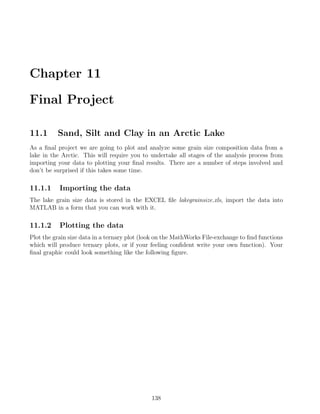
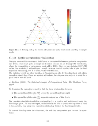
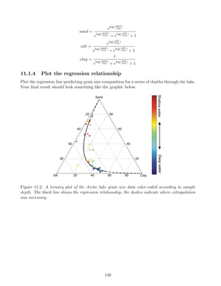
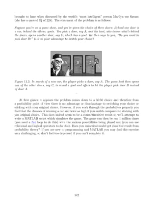
![Chapter 12
Exercise Solutions
It is important to realize that the exercises in this course can be solved in a variety of different
ways, therefore the solutions I will give are by no means the “definitive answer”. I’ve have
attempted to provide solutions which are written in a clear manner in order to help you under-
stand what is happening, this means that the code may be somewhat inefficient and from the
point of view of computation speed can certainly be improved.
12.1 Solution: Mmmm, π
There are three main tasks to solve this exercise:
1. Generating the numbers between 0 and 10000 to act as n.
2. Calculating the terms of the series using the values of n.
3. Finally, summing the series and multiplying by 4 to estimate π.
These three tasks can be performed using simple one-line commands. First we need to generate
a variable n which contains the integers between 0 and 10000:
n = [0:1:10000];
Now we must calculate each term of the series according to expression:
(−1)n
2n + 1
We’ll perform this calculation and place the result in a variable called terms (note, my variable
names are completely arbitrary, you can use any names you want as long as they follow the
rules we discussed earlier).
terms = (-1).^n./(2*n+1);
You’ll notice that the order of evaluation is important here and it is necessary to place brackets
around the -1. Finally, we simply need to add all the terms together using the inbuilt sum
function and multiply by 4 to make our estimate of π.
144](https://image.slidesharecdn.com/anintroductiontomatlabforgeoscientists-231208112439-be4fa83c/85/An-Introduction-to-MATLAB-for-Geoscientists-pdf-145-320.jpg)
![p = sum(terms)*4
Putting this all together our script for estimating π using the method of Madhava of Sangam-
agrama would look like:
n = [0:1:10000];
terms = (-1).^n./(2*n+1);
p = sum(terms)*4
12.1.1 Golf Solution: Mmmm, π
If you remember, MATLAB Golf involves coding a problem in as few characters as possible.
The following lines present one solution in a compact form which takes advantage of a number
of MATLAB’s shortcuts. It uses 30 characters:
n=0:1e4
sum((-1).^n./(2*n+1))*4
12.2 Solution: Mmmm, a second helping of π
To convert our script file into M-function we need to perform three tasks:
1. Add a header line defining the function name (madhava), the input (N) and output (p).
2. Define the values of n to be used as ranging between 0 and N
3. Add suitable help and comments
Our original script file looked like:
n = [0:1:10000];
terms = (-1).^n./(2*n+1);
p = sum(terms)*4
In order to convert this into a M-function we just add an appropriate header line and give
N as the maximum value of n.
function p = madhava(N)
n = [0:1:N];
terms = (-1).^n./(2*n+1);
p = sum(terms)*4;
145](https://image.slidesharecdn.com/anintroductiontomatlabforgeoscientists-231208112439-be4fa83c/85/An-Introduction-to-MATLAB-for-Geoscientists-pdf-146-320.jpg)
![Once the function is saved (make sure the filename is the same as the defined function name)
you can call it from the MATLAB command window with a defined value of N.
p = madhava(10000)
p =
3.1417
We should also add help and comments to explain the purpose of the function and the steps it
makes in the calculation.
function p = madhava(N)
%madhava - Estimate pi using the Madhava-Leibniz series
%
% Syntax: p = madhava(N)
%
% Inputs:
% N - the maximum term to be included
%
% Outputs:
% p - estimate of pi
%
% Other m-files required: none
% Subfunctions: none
% MAT-files required: none
%
% Author: Dave Heslop
% Department of Geosciences, University of Bremen
% email address: dheslop@uni-bremen.de
% Last revision: 6-Dec-2008
%------------- BEGIN CODE --------------
n = [0:1:N]; %form the integer terms
terms = (-1).^n./(2*n+1); %calculate series terms
p = sum(terms)*4; %sum all terms (to give pi/4) and multiply
%------------- END CODE --------------
12.3 Solution: The Geiger counter
This exercise is more complicated than the previous ones. We will solve it in a simple way by
testing a number of possible values of Ntrue then selecting the one which gives a value closest
to our desired Nobs. We’ll start by developing the code in a script file with fixed values of
146](https://image.slidesharecdn.com/anintroductiontomatlabforgeoscientists-231208112439-be4fa83c/85/An-Introduction-to-MATLAB-for-Geoscientists-pdf-147-320.jpg)
![Nobs = 8000 cps and τ = 20 x 10−6
s. The first thing to do is define these values in suitably
named variables:
Nobs=8000;
tau=20e-6;
Now we’ll create an array of Ntrue values to test, in this case ranging between 1 and 100000:
Ntest=[1:1e5];
To calculate the observed count rate which would be produced by each of the values in Ntest
we place them in our equation:
Ncalc=Ntest.*exp(-Ntest.*tau);
We now have an array (Ncalc) which contains the predicted observed count rate for each of the
guessed values in Ntest. To find which produces a prediction which is closest to Nobs we take
the root squared difference between Ncalc and Nobs:
Ndiff=sqrt((Ncalc-Nobs).^2);
The position within Ndiff that has the smallest value tells us the location in Ntest which
provides the best prediction for Nobs. To find this index position we can use the inbuilt func-
tion sort, this takes an array and reorders it from lowest to highest value and gives a second
output with the original index positions of the values before they were sorted.
[Ndiff min,idx]=sort(Ndiff);
We now know that our best guess for Ntrue lies in Ntest at the index given in the first po-
sition of idx:
Ntrue=Ntest(idx(1))
Ntrue =
9716
So, for an observed count rate of 8000 cps and τ = 20 x 10−6
s, we can estimate that Ntrue
= 9716 cps. We now have the basic workings of our code and we need to convert it into an
M-function. This means we need to think about input and output values. The required inputs
will be:
• The observed count rate (called Nobs)
• The dead-time (called tau)
• The array of values to test (called Ntest)
147](https://image.slidesharecdn.com/anintroductiontomatlabforgeoscientists-231208112439-be4fa83c/85/An-Introduction-to-MATLAB-for-Geoscientists-pdf-148-320.jpg)
![We only need a single output, the predicted value of Ntrue, which will be called Ntrue. All this
information, including the desired function name, can then be included in a header line followed
by the commands we developed above.
function Ntrue = geiger(Nobs,tau,Ntest)
Ncalc=Ntest.*exp(-Ntest.*tau);
Ndiff=sqrt((Ncalc-Nobs).^2);
[Ndiff min,idx]=sort(Ndiff);
Ntrue=Ntest(idx(1));
The M-function can be tested with the same problems as we used before, that way we can check
that nothing has gone wrong:
Nobs=8000;
tau=20e-6;
Ntest=[1:1e5];
Ntrue = geiger(Nobs,tau,Ntest)
Ntrue =
9716
Finally we should add help lines and comments to explain how the function works.
function Ntrue = geiger(Nobs,tau,Ntest)
%geiger - Predict the count rate of a Geiger counter
%
% Syntax: Ntrue = geiger(Nobs,tau,Ntest)
%
% Inputs:
% Nobs - Observed count rate [cps]
% tau - dead-time [s]
% Ntest - range of count rates to test [cps]
%
% Outputs:
% Ntrue - Predicted true count rate [cps]
%
% Other m-files required: none
% Subfunctions: none
% MAT-files required: none
%
% Author: Dave Heslop
% Department of Geosciences, University of Bremen
% email address: dheslop@uni-bremen.de
% Last revision: 6-Dec-2008
148](https://image.slidesharecdn.com/anintroductiontomatlabforgeoscientists-231208112439-be4fa83c/85/An-Introduction-to-MATLAB-for-Geoscientists-pdf-149-320.jpg)
![%------------- BEGIN CODE --------------
Ncalc=Ntest.*exp(-Ntest.*tau); %predicted cps
Ndiff=sqrt((Ncalc-Nobs).^2); %rs difference with observed
[Ndiff min,idx]=sort(Ndiff); %locate smallest difference
Ntrue=Ntest(idx(1)); %select best fitting value
%------------- END CODE --------------
12.4 Solution: Classifying sediments
In this exercise you were asked to analyze grain size data from the file grainsize.mat in order to
find how many samples contained certain amounts of sand, silt and clay. Specifically:
1. How many samples contain more than 50% sand?
2. How many samples contain more than 50% silt?
3. How many samples contain more than 30% silt or more than 25% clay?
4. How many samples contain more than 40% sand, less than 40% silt and more than 40%
clay?
The first task is to load the data into MATLAB (plus we will clear the memory before starting:
clear all
load grainsize
The variable gs is now in the memory which contains the data for the sand (first column),
silt (second column) and clay (third column) percentages. Each row of the gs matrix represents
a different sample. We now need to use a combination of relational and logical operators to
answer the questions. Lets start with “How many samples contain more than 50% sand?”. The
first thing we need to consider is that the information on sand content is contained in the first
column of gs, therefore to access the sand content for all the samples we will use the address
gs(:,1). We can now find the number of samples with more than 50% sand in two different
ways, in the first we will return an array of logical values (1s signify samples which meet the
criteria and 0s signify those that don’t) and simply add together all the entries:
output=gs(:,1)50
sum(output)
ans =
19
Alternatively, we can use the find function to provide an array containing the indices of the
samples which met the criteria and then simply find how many entries are in the array using
the function numel:
149](https://image.slidesharecdn.com/anintroductiontomatlabforgeoscientists-231208112439-be4fa83c/85/An-Introduction-to-MATLAB-for-Geoscientists-pdf-150-320.jpg)
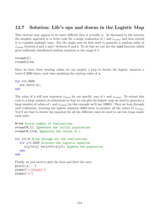
![12.8 Solution: Plotting elevation data
The exercise requires loading and plotting the elevation data from the file Hawaii.mat. The first
task is to load the data and look at the variables:
load Hawaii
The first thing we need to do is make regularly spaced arrays of latitude and longitude, which
pass from their minimum to maximum values in steps of 0.1o
. To do this we can use the func-
tions min and max, we’ll call the arrays X (for the longitude) and Y (for the latitude).
X=[min(longitude):0.1:max(longitude)];
Y=[min(latitude):0.1:max(latitude)];
Now we’ll make regular grids called Xgrid and Ygrid from the X and Y arrays using the meshgrid
function and then interpolate the elevation data onto the grids.
[Xgrid,Ygrid]=meshgrid(X,Y);
Zgrid=griddata(longitude,latitude,elevation,Xgrid,Ygrid);
To plot the topographic surface we need to make a copy of Zgrid, which we’ll call topo,
and the replace all the values below zero with 0. This basically means we are taking all the
points below sealevel and replacing them with zeros. Then we’ll plot the data using surf and
add labels to the axes.
topo=Zgrid; %make a copy of the data
idx=find(topo0); %find the indicies of the points below zero
topo(idx)=0; %replace these points with zeros
figure %create a new figure window
surf(Xgrid,Ygrid,topo) %plot the data grids as a surface
xlabel('Longitude [o]') %add a x-axis label
ylabel('Latitude [o]') %add a y-axis label
zlabel('Height [m]') %add a z-axis label
Producing a bathymetric map follows exactly the same ideas, except this time when we make a
copy of the data we will replace the height values greater than zero with 0.
bath=Zgrid; %make a copy of the data
idx=find(bath0); %find the indicies of the points above zero
bath(idx)=0; %replace these points with zeros
figure %create a new figure window
surf(Xgrid,Ygrid,bath) %plot the data grids as a surface
xlabel('Longitude [o]') %add a x-axis label
ylabel('Latitude [o]') %add a y-axis label
zlabel('Depth [m]') %add a z-axis label
155](https://image.slidesharecdn.com/anintroductiontomatlabforgeoscientists-231208112439-be4fa83c/85/An-Introduction-to-MATLAB-for-Geoscientists-pdf-156-320.jpg)
![first thing to do is form the log-ratios of the grain size components using clay as the denomi-
nator variable:
sand clay=log(sand./clay)
silt clay=log(silt./clay)
Now we must find the straight-line relationship between the log of depth and the log-ratios
of the grain size components. There are many ways to do this but one of the simplest is to
use the function polyfit, which requires 3 inputs, the independent data which in this case is
the log of depth, the dependant data which in this case is the one of the log-ratios, and finally
the order of the polynomial to be fitted (we want a straight-line which is order 1). The output
variables from polyfit store the structure of the polynomial fit, which for a straight-line is the
values of the gradient and the intercept.
p sand clay=polyfit(log(depth),sand clay,1);
p silt clay=polyfit(log(depth),silt clay,1);
In order to draw our regression line representing the relationship between lake depth and grain
size composition we must first define a series of depths that we’ll call D. Then we’ll find the
grain size compositions for the log of these depths according our derived regression relation-
ships. This can be done using the function polyval which will evaluate a polynomial with
known coefficients for a given value. You can see in the commands below we supply polyval
with the polynomial coefficients calculated in the previous step and ask it to determine values
at the logs of the new depth points.
D=[1:1:500]; %series of new depths for the model
sand clay hat=polyval(p sand clay,log(D)); %log(sand/clay) model
silt clay hat=polyval(p silt clay,log(D)); %log(silt/clay) model
Our predictions for the grain sizes are still in the form of log-ratios, but we can convert them
back into sand, silt and clay proportions using the equations given in the exercise:
sand hat=exp(sand clay hat)./(exp(sand clay hat)+exp(silt clay hat)+1);
silt hat=exp(silt clay hat)./(exp(sand clay hat)+exp(silt clay hat)+1);
clay hat=1./(exp(sand clay hat)+exp(silt clay hat)+1);
Finally, we just need to add our new regression points as a line in the ternary plot:
ternplot(clay hat,sand hat,silt hat,'r') %Add the regression to the plot
157](https://image.slidesharecdn.com/anintroductiontomatlabforgeoscientists-231208112439-be4fa83c/85/An-Introduction-to-MATLAB-for-Geoscientists-pdf-158-320.jpg)
![12.11 Solution: Bringing it all together with cars and
goats
The best way to proceed with the problem is to think how we would play the game once and
build that into a repeating process so that we can play millions of times and examine the prob-
ability of the different results. Lets start with the basic mechanics of the game which we can
break down into parts, firstly we need to decide on the combination of goats and car which will
be behind the doors. To make this a bit easier we will always use the sequence car-goat-goat
and randomly generate the door numbers they are behind. This means we need to produce the
numbers 1,2 and 3 in an random order, which can be done by generating three random numbers
and finding the indices which will sort them into ascending (or descending) order, for example:
r=rand(3,1);
[r,door]=sort(r);
door
door =
3
1
2
This means that for this specific game the car would be behind door 3 and goats would be
behind doors 1 and 2. The same process can be combined into a single line:
[door,door]=sort(rand(3,1));
We can perform a similar process to obtain the first guess of the contestant, again we’ll generate
the numbers 1,2 and 3 in a random order and take the first number as the guess:
[guess,guess]=sort(rand(3,1));
guess=guess(1)
guess =
1
So in this case the contestants first guess would be that the car is behind door 1. Now we
can test the first case, did the contestant correctly guess the door in the first instance, if they
did we then have to decide what happens at the next stage, will they stick with their original
choice, in which case they will win the car, or will they switch, in which case they will win a
goat. To represent the choice of wether to switch doors or not we’ll generate a random number
between 0 and 1, if the value is 0.5 the contestant sticks with the original door, of the number
is 0.5 they will switch.
switch door=rand(1);
if guess==doors(1) %the correct door was chosen at the beginning
158](https://image.slidesharecdn.com/anintroductiontomatlabforgeoscientists-231208112439-be4fa83c/85/An-Introduction-to-MATLAB-for-Geoscientists-pdf-159-320.jpg)
![if switch door0.5 %if the number is 0.5 the door isn’t switched
disp('You win a car')
end
end
The opposite situation is a simple extension of this, if the contestant did not originally choose
the correct door then they will only win a car if the value of switch door is greater then 0.5.
Therefore both possibilities to win the car can be written as:
switch door=rand(1);
if guess==doors(1) %the correct door was chosen at the beginning
if switch door0.5 %if the number is 0.5 the door isn’t switched
disp('You win a car')
end
end
if guess∼=doors(1) %an incorrect door was chosen at the beginning
if switch door0.5 %if the number is 0.5 the door is switched
disp('You win a car')
end
end
We now have the structure of the code with which we can play a single game, but we need
to make adjustments so that we can play it repeatedly. If you remember our original question
we wanted to know if we are more likely to win if we switch doors (which we’ll call a type1 win)
rather than sticking with the same door (a type2 win). All we need to do is place the game
simulation within loop so that we can run it a number of times and add up the number of type1
and type2 wins. Finally, we can find the relative probabilities by calculating the total number
of type1 wins compared to the total number of wins.
type1 total=0;
type2 total=0;
for iter=1:1e5
[doors,doors]=sort(rand(3,1));
[guess,guess]=sort(rand(3,1));
guess=guess(1);
switch door=rand(1);
if guess==doors(1) %the correct door was chosen at the beginning
if switch door0.5 %if the number is 0.5 the door isn’t switched
type2 total=type2 total+1;
end
end
159](https://image.slidesharecdn.com/anintroductiontomatlabforgeoscientists-231208112439-be4fa83c/85/An-Introduction-to-MATLAB-for-Geoscientists-pdf-160-320.jpg)