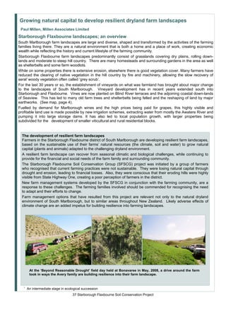
Farmers in the Starborough Flaxbourne region of New Zealand are developing more resilient farm landscapes through sustainable management practices. The Starborough Flaxbourne Soil Conservation Group was formed when farmers realized current practices were unsustainable due to drought and erosion. The group worked with farmers to develop new strategies including matching livestock and feed production to climate and soils, establishing shelterbelts and native vegetation, reducing grazing pressure, and creating farm reserves. These practices aim to grow natural capital through increased plant and tree cover while maintaining viable farming operations.
Remineralize the Earth promotes the regeneration of soils and forests worldwide with finely ground rock dust as an economically and ecologically sustainable alternative to chemical fertilizers and pesticides, creating fertile soils much as the earth does.
Thanks to North American Green BioNet erosion control blankets, Highway 14 the runs through Yellowstone National Park is full of vegetation and erosion free:
Phillip Is, Pacific Ocean: Drivers of landscape degradation and recovery and ...Richard Thackway
We present an assessment of the modification of the vegetation condition found on Phillip Island relative to a fully natural pre-European (1750) reference state and the current land and sea birds recorded on the Island. The island became denuded between the late 1700s and mid-1850s. Introductions of pigs, goats and rabbits were made to feed to penal colony of the nearby Norfolk Island. Almost complete loss of vegetation types, extent and condition is attributed to a deliberate land management regime: used to feed the pigs and goats. Pigs and goats became extinct with the loss of vegetation on the Island. Rabbits persisted on the Island until 1988, when they were eradicated. Changes in the extent of vegetation cover has been remarkable from a very low level up to 1900-1980 (estimated <1%); it now covers large areas of the island including valleys and gulleys and cliffs (estimated 50%). Our analyses show that the condition of the largely passively recovered vegetation extent is not of a high condition relative to an assumed reference state (1750) for Pine – Hardwood Subtropical Rainforest. A reconstructed pre-European settlement (original) list of sea birds shows that sea birds diversity on the island have changed little in three recent bird surveys (1978-2015). A reconstructed pre-European settlement (original) list of land birds shows that land birds have obviously changed, with many of the current species not represented in the pre-European list. The current list of land birds, which make up most of the current list of species recorded on Phillip Island have invaded from the nearby Norfolk Island. We conclude that current bird species diversity and distribution on the island is a not a function of the condition of the indigenous native vegetation, assessed relative to a pre-European reference state, but rather it appears to be a response to the lack of mammalian grazing mammals and the present of open to dense shrubby vegetation.
Development of wasteland under social forestry programmejaimangal tirkey
Development of Wasteland under Social Forestry Programme
The problem of wasteland has become a serious issue and it has increased with the development of technology for increasing the agricultural production (Swaminathan, 1997). The natural disturbances including the man-made problems, i.e. industrialization and urbanization, contribute to increasing trend of wastelands in various ways. The requirement by the increasing human population and cattle population and also the natural disasters cause the loss of natural resources and land degradation (Hegde, 1993).According to Food and Agriculture Organization of the United Nations (FAO, 1992), the various forms of land degradation such as soil erosion, chemical poisoning, stalinization and loss through building or mining is of 5 to 7 million hectares from good cultivable lands
Wasteland
Wastelands include degraded forests, overgrazed pastures, drought-struck pastures, eroded valleys, hilly slopes, waterlogged marshy lands, barren land etc.
Types of Wastelands:
(a) Cultivable Wastelands
(b) Uncultivable Wastelands
Conservation agriculture in the context of climate change in West AfricaRobert Zougmoré
One of CCAFS over-arching objectives is to assess and test pro-poor adaptation and mitigation practices, technologies and policies for food systems, adaptive capacity and rural livelihoods. Conservation agriculture (CA) is one of the promising climate-smart agriculture options as it allows benefiting from the synergies between adaptation and mitigation while also improving the livelihoods of smallholder farmers. As such, CA promotion needs to be tapped into the general framework for a sound and widespread adoption of evidence-based technologies in West Africa. Getting the big pictures to insure millions of farmers will require sound scaling-up approaches of successful CA options for the semi-arid West Africa.
Limiting factors for pasture and cereal production in marginal soils of the s...Agriculture Journal IJOEAR
Abstract— Typical soils of Southwestern Buenos Aires Province were evaluated to determine quality and capability for cereal and forage production having in mind potential improvements due to amendment with organic residual from agroindustrial wastes process. Studied soils from Mollisol order were, Argiudoll and Argiustol suborder, of marginal area of Pampa Argentina. The organic matter content of those soils corresponded to weakly humic soils which shows the transition from the Pampas zone to the semi-arid zone and indicates a major limiting factor. Granulometric analyses were similar, with a sandy loam texture for the Tres Arroyos soil and a borderline sandy silt loam for the Cabildo soil. Anycase the results were below the limit that indicates salinity problems. Low availability of essential micronutrient like Copper and Molibdenum were another limiting factor of the Tres Arroyos soil, where the cultivation of winter grains, such as wheat and barley is very important for regional economy. The availability of the micronutrients Zn and Cu are strongly dependent on the soil pH; therefore, the more alkaline the conditions (such as for the Cabildo soil), as a limiting factor mainly for cereals sensitive to Cinc deficiencies like maize and sorghum. Soils from this marginal areas of the Pampas (Argentina), could be improved with respect to the factors that limit soil quality and productivity.
Soil conservation practices can reduce soil erosion caused by flooding, wind and other agents. As well soil conservation practices restore fertility, fauna and flora and reduce contamination caused by chemicals...
Resilient dryland systems -A brief overview (Asia)ICRISAT
To improve rural livelihoods, increase food security and protect the environment through sustainable intensification adopting holistic participatory research for development (PR4D) to benefit small farm holders in the semi-arid tropics
A closer look at wasteland and their reclamationSagar Chaudhary
The reclamation of wasteland and development measures in general includes land clearing, soil and water conservation, enhancing nutrient status, provision of irrigation facilities and so on. However, the existing status of wastelands shows wide variation across different regions of the country in terms of their suitability for cultivation. Therefore, it is necessary to carry out a scientific assessment of the existing status; fertility, erosion levels, soil conditions, water potential, suitable cropping system, etc. of the waste lands spread over different agro-climatic zones of the state so as to prepare a realistic reclamation-cum-development plan for the wastelands. Thus rehabilitation of the wasteland through the sustainable management serves as a better cover to the soil and aids regeneration of forests.
Hawai‘i Low Land Mesic Forest Restoration Manual (May 2015)HHFplanners
This manual has been produced as part two of a series on Hawaiian native ecosystem restoration. Part one of this series is the "Hawai‘i Native Plant Microbiome Manual."
Rethinking swidden cultivation in myanmar pyoe pyin 2014YMCA Mandalay
Swidden cultivation, also know as shifting cultivation or Shwe Pyaung Taung-ya, describes a spectrum of rotational agro-forestry practices at varying levels of intensity prevalent in Myanmar’s uplands. Swidden cultivation contributes to the livelihoods of millions of citizens, for whom it is a solution to upland food security.
Unit 8 - Information and Communication Technology (Paper I).pdfThiyagu K
This slides describes the basic concepts of ICT, basics of Email, Emerging Technology and Digital Initiatives in Education. This presentations aligns with the UGC Paper I syllabus.
Welcome to TechSoup New Member Orientation and Q&A (May 2024).pdfTechSoup
In this webinar you will learn how your organization can access TechSoup's wide variety of product discount and donation programs. From hardware to software, we'll give you a tour of the tools available to help your nonprofit with productivity, collaboration, financial management, donor tracking, security, and more.
The French Revolution, which began in 1789, was a period of radical social and political upheaval in France. It marked the decline of absolute monarchies, the rise of secular and democratic republics, and the eventual rise of Napoleon Bonaparte. This revolutionary period is crucial in understanding the transition from feudalism to modernity in Europe.
For more information, visit-www.vavaclasses.com
Synthetic Fiber Construction in lab .pptxPavel ( NSTU)
Synthetic fiber production is a fascinating and complex field that blends chemistry, engineering, and environmental science. By understanding these aspects, students can gain a comprehensive view of synthetic fiber production, its impact on society and the environment, and the potential for future innovations. Synthetic fibers play a crucial role in modern society, impacting various aspects of daily life, industry, and the environment. ynthetic fibers are integral to modern life, offering a range of benefits from cost-effectiveness and versatility to innovative applications and performance characteristics. While they pose environmental challenges, ongoing research and development aim to create more sustainable and eco-friendly alternatives. Understanding the importance of synthetic fibers helps in appreciating their role in the economy, industry, and daily life, while also emphasizing the need for sustainable practices and innovation.
The Roman Empire A Historical Colossus.pdfkaushalkr1407
The Roman Empire, a vast and enduring power, stands as one of history's most remarkable civilizations, leaving an indelible imprint on the world. It emerged from the Roman Republic, transitioning into an imperial powerhouse under the leadership of Augustus Caesar in 27 BCE. This transformation marked the beginning of an era defined by unprecedented territorial expansion, architectural marvels, and profound cultural influence.
The empire's roots lie in the city of Rome, founded, according to legend, by Romulus in 753 BCE. Over centuries, Rome evolved from a small settlement to a formidable republic, characterized by a complex political system with elected officials and checks on power. However, internal strife, class conflicts, and military ambitions paved the way for the end of the Republic. Julius Caesar’s dictatorship and subsequent assassination in 44 BCE created a power vacuum, leading to a civil war. Octavian, later Augustus, emerged victorious, heralding the Roman Empire’s birth.
Under Augustus, the empire experienced the Pax Romana, a 200-year period of relative peace and stability. Augustus reformed the military, established efficient administrative systems, and initiated grand construction projects. The empire's borders expanded, encompassing territories from Britain to Egypt and from Spain to the Euphrates. Roman legions, renowned for their discipline and engineering prowess, secured and maintained these vast territories, building roads, fortifications, and cities that facilitated control and integration.
The Roman Empire’s society was hierarchical, with a rigid class system. At the top were the patricians, wealthy elites who held significant political power. Below them were the plebeians, free citizens with limited political influence, and the vast numbers of slaves who formed the backbone of the economy. The family unit was central, governed by the paterfamilias, the male head who held absolute authority.
Culturally, the Romans were eclectic, absorbing and adapting elements from the civilizations they encountered, particularly the Greeks. Roman art, literature, and philosophy reflected this synthesis, creating a rich cultural tapestry. Latin, the Roman language, became the lingua franca of the Western world, influencing numerous modern languages.
Roman architecture and engineering achievements were monumental. They perfected the arch, vault, and dome, constructing enduring structures like the Colosseum, Pantheon, and aqueducts. These engineering marvels not only showcased Roman ingenuity but also served practical purposes, from public entertainment to water supply.
Students, digital devices and success - Andreas Schleicher - 27 May 2024..pptxEduSkills OECD
Andreas Schleicher presents at the OECD webinar ‘Digital devices in schools: detrimental distraction or secret to success?’ on 27 May 2024. The presentation was based on findings from PISA 2022 results and the webinar helped launch the PISA in Focus ‘Managing screen time: How to protect and equip students against distraction’ https://www.oecd-ilibrary.org/education/managing-screen-time_7c225af4-en and the OECD Education Policy Perspective ‘Students, digital devices and success’ can be found here - https://oe.cd/il/5yV
Palestine last event orientationfvgnh .pptxRaedMohamed3
An EFL lesson about the current events in Palestine. It is intended to be for intermediate students who wish to increase their listening skills through a short lesson in power point.
The Indian economy is classified into different sectors to simplify the analysis and understanding of economic activities. For Class 10, it's essential to grasp the sectors of the Indian economy, understand their characteristics, and recognize their importance. This guide will provide detailed notes on the Sectors of the Indian Economy Class 10, using specific long-tail keywords to enhance comprehension.
For more information, visit-www.vavaclasses.com
How to Make a Field invisible in Odoo 17Celine George
It is possible to hide or invisible some fields in odoo. Commonly using “invisible” attribute in the field definition to invisible the fields. This slide will show how to make a field invisible in odoo 17.
This is a presentation by Dada Robert in a Your Skill Boost masterclass organised by the Excellence Foundation for South Sudan (EFSS) on Saturday, the 25th and Sunday, the 26th of May 2024.
He discussed the concept of quality improvement, emphasizing its applicability to various aspects of life, including personal, project, and program improvements. He defined quality as doing the right thing at the right time in the right way to achieve the best possible results and discussed the concept of the "gap" between what we know and what we do, and how this gap represents the areas we need to improve. He explained the scientific approach to quality improvement, which involves systematic performance analysis, testing and learning, and implementing change ideas. He also highlighted the importance of client focus and a team approach to quality improvement.
How to Split Bills in the Odoo 17 POS ModuleCeline George
Bills have a main role in point of sale procedure. It will help to track sales, handling payments and giving receipts to customers. Bill splitting also has an important role in POS. For example, If some friends come together for dinner and if they want to divide the bill then it is possible by POS bill splitting. This slide will show how to split bills in odoo 17 POS.
Growing Natural Capital to Develop Resilient Dryland Farm Landscapes - New Zealand
1. Growing natural capital to develop resilient dryland farm landscapes
Paul Millen, Millen Associates Limited
Starborough Flaxbourne landscapes; an overview
South Marlborough farm landscapes are large and diverse, shaped and transformed by the activities of the farming
families living there. They are a natural environment that is both a home and a place of work, creating economic
wealth while reflecting the history and current lifestyle of the farming community.
Starborough Flaxbourne farm landscapes predominantly consist of grasslands covering dry plains, rolling down-
lands and moderate to steep hill country. There are many homesteads and surrounding gardens in the area as well
as shelterbelts and some farm woodlots.
While on some properties there is extensive erosion, elsewhere there is good vegetation cover. Many farmers have
reduced the clearing of native vegetation in the hill country by fire and machinery, allowing the slow recovery of
seral1 woody vegetation often called ‘grey scrub’.
For the last 30 years or so, the establishment of vineyards on what was farmland has brought about major change
to the landscapes of South Marlborough. Vineyard development has in recent years extended south into
Starborough and Flaxbourne. Vines are now planted on Blind River terraces and the adjoining coastal down-lands
of Seaview. This has led to many old farm trees and shelterbelts being felled and the reshaping of land by major
earthworks. (See map, page 4).
Fuelled by demand for Marlborough wines and the high prices being paid for grapes, this highly visible and
profitable land use is made possible by new irrigation schemes, extracting water from mostly the Awatere River and
pumping it into large storage dams. It has also led to local population growth, with larger properties being
subdivided for the development of smaller viticultural and rural residential blocks.
The development of resilient farm landscapes
Farmers in the Starborough Flaxbourne district of South Marlborough are developing resilient farm landscapes,
based on the sustainable use of their farms’ natural resources (the climate, soil and water) to grow natural
capital (plants and animals) adapted to the challenging dryland environment.
A resilient farm landscape can recover from seasonal climatic and biological challenges, while continuing to
provide for the financial and social needs of the farm family and surrounding community.
The Starborough Flaxbourne Soil Conservation Group (SFSCG) project was initiated by a group of farmers
who recognised that current farming practices were not sustainable. They were losing natural capital through
drought and erosion, leading to financial losses. Also, they were conscious that their eroding hills were highly
visible from State Highway One, creating a poor perception of farmers in the district.
New farm management systems developed by the SFSCG in conjunction with the farming community, are a
response to these challenges. The farming families involved should be commended for recognising the need
to adapt and their efforts to change.
Farm management options that have resulted from this project are relevant not only to the natural dryland
environment of South Marlborough, but to similar areas throughout New Zealand. Likely adverse effects of
climate change are an added impetus for building resilience into farming landscapes.
At the ‘Beyond Reasonable Drought’ field day held at Bonavaree in May, 2008, a drive around the farm
took in ways the Avery family are building resilience into their farm landscape.
1
An intermediate stage in ecological succession
37 Starborough Flaxbourne Soil Conservation Project
2. Farm management options for growing natural capital in South Marlborough
The Starborough Flaxbourne Soil Conservation Project has shown that with innovation and new knowledge, farmers can
utilise their properties’ unique natural resources to create successful dryland farming operations that are sustainable even
in the event of significant climatic challenges. The options outlined below are better suited to some properties than to
others, and to some farmers and not others.
Match feed production to climate and soils, and stock production to feed availability
Increase feed production by establishing plants that are adapted to the climate and soils. Match stock numbers to the
increased feed available.
Potential plants include drought-tolerant grasses and herbaceous plants adapted to the annual seasonal dry, for example
short rotation ryegrasses, cereal greenfeeds, lucerne or sub clover. These plants provide stock with high quality feed to
boost lambing and weaning percentages and ensure stock are finished for sale in early summer as pasture production
declines.
By reducing stock numbers significantly for the main summer period, a good cover can be retained. For more on
managing feed availability, see Chapters 3, 4 and 5 (Moot and Avery, Ogle and Wills).
Irrigate fertile land
Sustainable water sources are being investigated as an option for diversifying farm production by irrigating vineyards,
horticultural crops, or high producing feed species.
Reduce stock pressure and oversow, or plant fodder shrubs to combat erosion with good vegetative cover
Fencing of eroding hill slopes alone, can encourage seeding of grasses and legumes by reducing stock pressure.
Alternatively, plant stock fodder species for example, saltbush and tagasaste. These can grow reasonably fast and
develop deep root systems. Well established plants intercept rainfall and slow surface runoff. They shade the soil, reduce
ground temperatures and minimise evaporation. Over a period of time, leaf litter and soil organic matter build up,
increasing soil moisture holding capacity and stabilising eroding hill slopes. Once established, these plants can be grazed
and provide shelter and shade for stock.
Plant shelterbelts and shade trees
A framework of trees will benefit stock throughout all seasons, offering shelter and shade. Shelter reduces lambing
losses, enhances pasture and crop production and reduces soil loss from wind erosion while shade in summer improves
animal welfare.
Establish permanent shelterbelts and groups of trees using long-living species, for example oaks and ashes, possibly
totara. If fast-growing shelter is required, then tagasaste or eucalypts are an option.
Manage native scrub to provide shelter and shade and protect hill slopes
On some hill country, regenerating native grey scrub and silver tussock can provide valuable stock shelter and shade
while protecting hill slopes from erosion. Where regeneration becomes too extensive, clear areas sensitively and
selectively by methods such as root raking and/or chemical spraying or mechanical mulching, rather than by burning.
Create farm reserves to protect and restore natural biodiversity
South Marlborough’s native vegetation has many special features due to a wide diversity of natural habitats with some
unique endemic plant species that are adapted to surviving dry conditions.
Significant natural areas can be rocky bluffs or coastal cliffs; riverbeds and dunelands; remnant or regenerating gully or
hill forest or riparian regeneration along streams and around wetlands.
These natural areas can be protected and restored by creating farm reserves in partnership with the Marlborough District
Council under the Significant Natural Areas (SNA) project. The Council offers advice and field assistance as well as
financial support. Support for protecting native vegetation can also be sought from Department of Conservation
Biodiversity Fund as well as the QE II National Trust.
Plant woodlots to produce timber suitable for on farm use or sale
Where there is good access and suitable sheltered sites, establish small-scale farm woodlots to produce naturally
durable farm timber that can be sawn on-site. Suitable durable timber species that are adapted to drylands include
stringybarks, ironbarks and box eucalypts. These mature in the medium term (25-50 years). Oak, and possibly totara
could also be planted to mature over a longer term (50+ years).
Woodlots require fencing to protect new plantings. With pruning and thinning, they can produce valuable timber and
once established, will provide shelter and shade.
Develop farm tourism
Tourism offers the wider community an opportunity to diversify its economy and access an alternative income source.
The Starborough Flaxbourne district is readily accessible to tourists, being located on SH 1. This is New Zealand’s driest
district and oldest farm landscape, with unique native plants and an attractive coastline.
Successful farm tourism ventures could be based on telling the stories of the district’s fascinating natural and cultural
history. Opening the doors of historic homesteads and gardens, developing walking and cycling routes and partnering
with others in the community, are all options.
38 Starborough Flaxbourne Soil Conservation Project
3. Renewable energy generation
There are properties in the area with the potential for wind-farming. This could raise issues over the landscape
impact of the turbines and whether the community would regard wind-farms as spoiling the scenery. The potential
for on-farm small-scale wind energy generation could be further investigated.
Starborough Flaxbourne landscape model
The landscape model developed for the project was designed to visually present farm management options, using
the following computer-generated images based on four locations at Bonavaree.
The first two images present landscape changes achievable in the medium to longer term (15-20 years) on a range
of farm sites including:
• Flat valley floor and easy downs;
• Rolling coastal country;
• Moderate to steep north facing hill; and
• Moderate to steep south facing hill.
The major focus of these images is to identify and display woody plants, both native and exotic, with potential for the
Starborough Flaxbourne landscape and to present how these could look once established.
An additional image highlights local features and tourism opportunities within the local landscape.
39 Starborough Flaxbourne Soil Conservation Project