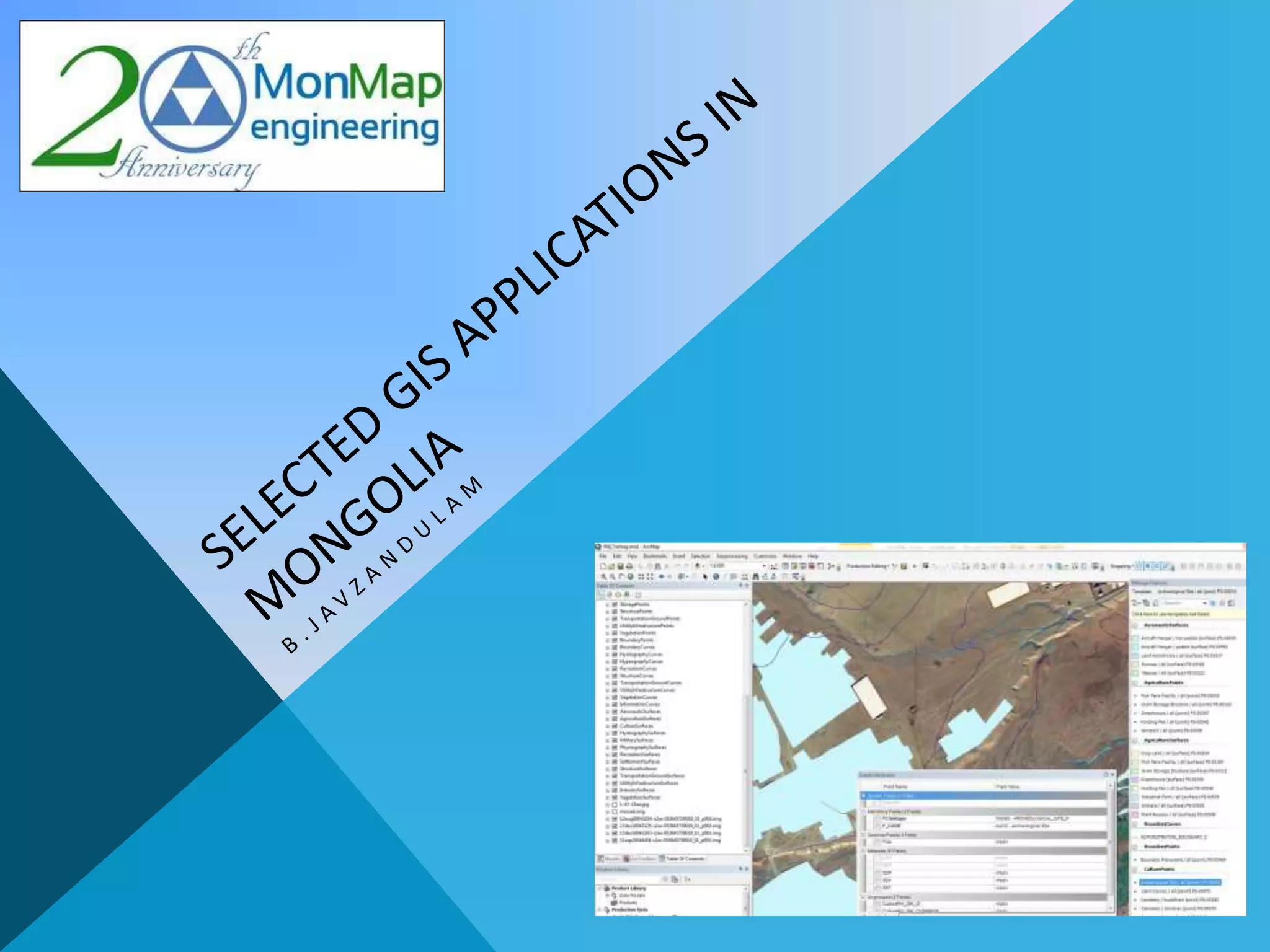
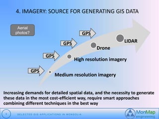
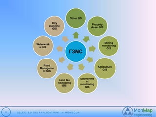
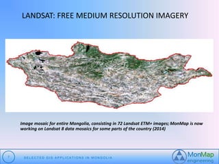
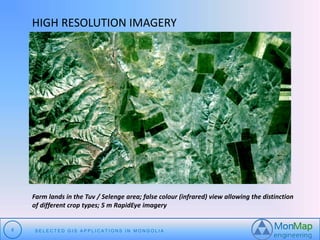
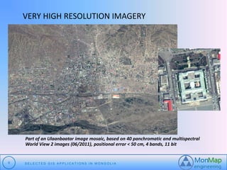
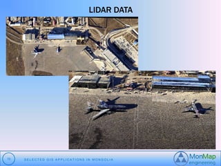
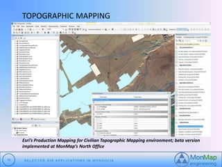
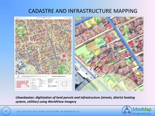
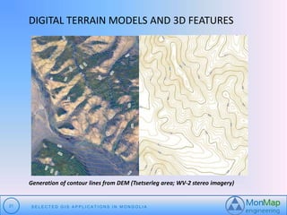
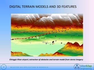
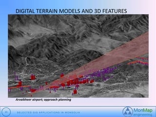
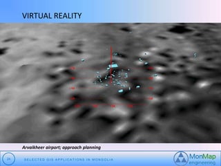
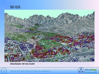
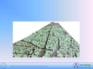
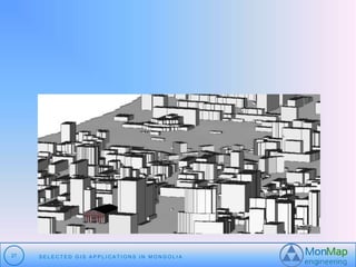
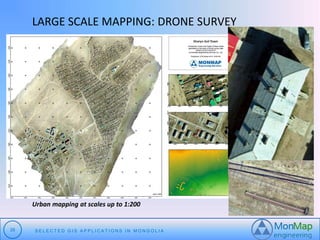
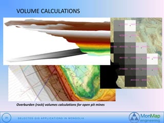
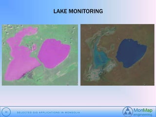
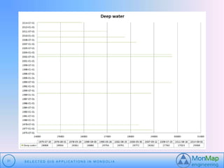
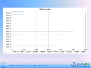
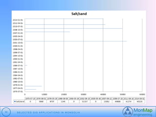
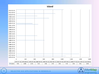
SlideShare a Scribd company logo
1 of 35
АГУУЛГА: 
1. “МонМэп”ХХК-ийн товч танилцуулга 
2. “ESRI” корпорацийн товч танилцуулга 
3. ГМС-ийг бий болгох суурь data 
4. Хэрэглээ 
2 S E L E C T E D G I S A P P L I C A T I O N S I N MO N G O L I A
1. “МОНМЭП”ХХК-ИЙН ТОВЧ ТАНИЛЦУУЛГА 
“МОНМЭП” ХХК нь 1992 оны 11-р сард байгуулагдсан геодезийн 
инженерийн үйлдвэрлэл үйлчилгээ эрхэлдэг хязгаарлагдмал хариуцлагатай 
компани юм. 
Эрхэм зорилго: Гадаад болон дотоодын захиалагч байгууллагын ажлыг 
чадварлаг боловсон хүчин, хамгийн сүүлийн үеийн техник технологиор 
стандартын дагуу геодезийн үйлдвэрлэл, үйлчилгээг үзүүлэн чанартай 
бүтээгдэхүүн болон үйлчилгээг хариуцлагатай гүйцэтгэхэд оршино. 
3 S E L E C T E D G I S A P P L I C A T I O N S I N MO N G O L I A
2.“ESRI” КОРПОРАЦИЙН ТОВЧ ТАНИЛЦУУЛГА 
 350,000 clients 
 3,000 employees 
 10 US offices 
 80 distributors worldwide 1,800+ partners 
4 S E L E C T E D G I S A P P L I C A T I O N S I N MO N G O L I A
4. IMAGERY: SOURCE FOR GENERATING GIS DATA 
High resolution imagery 
Medium resolution imagery 
5 S E L E C T E D G I S A P P L I C A T I O N S I N MO N G O L I A 
Drone 
LIDAR 
GPS 
GPS 
GPS 
GPS 
Aerial 
photos? 
Increasing demands for detailed spatial data, and the necessity to generate 
these data in the most cost-efficient way, require smart approaches 
combining different techniques in the best way
Other GIS 
ГЗМС 
Waterwork 
s GIS 
6 S E L E C T E D G I S A P P L I C A T I O N S I N MO N G O L I A 
Property 
Asset GIS 
Mining 
monitoring 
GIS 
Agriculture 
GIS 
Environme 
nt 
monitoring 
GIS 
Land tax 
monitoring 
GIS 
Road 
Manageme 
nt GIS 
City 
planning 
GIS
LANDSAT: FREE MEDIUM RESOLUTION IMAGERY 
Image mosaic for entire Mongolia, consisting in 72 Landsat ETM+ images; MonMap is now 
working on Landsat 8 data mosaics for some parts of the country (2014) 
7 S E L E C T E D G I S A P P L I C A T I O N S I N MO N G O L I A
HIGH RESOLUTION IMAGERY 
Farm lands in the Tuv / Selenge area; false colour (infrared) view allowing the distinction 
of different crop types; 5 m RapidEye imagery 
8 S E L E C T E D G I S A P P L I C A T I O N S I N MO N G O L I A
VERY HIGH RESOLUTION IMAGERY 
Part of an Ulaanbaatar image mosaic, based on 40 panchromatic and multispectral 
World View 2 images (06/2011), positional error < 50 cm, 4 bands, 11 bit 
9 S E L E C T E D G I S A P P L I C A T I O N S I N MO N G O L I A
LIDAR DATA 
10 S E L E C T E D G I S A P P L I C A T I O N S I N MO N G O L I A
11 S E L E C T E D G I S A P P L I C A T I O N S I N MO N G O L I A
GOING INTO DETAIL: DRONE SURVEY 
 Drone survey data provide even more 
details: 
 Up to 5 cm ground resolution 
 Orthomosaics and Digital Surface Models 
 Precise heights and volumes 
12 S E L E C T E D G I S A P P L I C A T I O N S I N MO N G O L I A
GEOREFERENCING IMAGES 
Co-registration of 2 images: collection of tie points 
13 S E L E C T E D G I S A P P L I C A T I O N S I N MO N G O L I A
EXTRACTING 3D DATA FROM IMAGES 
Ulaanbaatar; measuring building heights and digitizing objects in 3D from a 
stereo satellite image block 
14 S E L E C T E D G I S A P P L I C A T I O N S I N MO N G O L I A
EXTRACTING THEMATIC INFORMATION 
Zaamar gold mines; different sharpening methods: Ehlers Fusion (left side; good representation of 
spectral characteristics) versus Subtractive Resolution Merge (right side; more spatial details) 
15 S E L E C T E D G I S A P P L I C A T I O N S I N MO N G O L I A
EXTRACTING THEMATIC INFORMATION 
Oyu Tolgoi mining area: pan sharpened (hypershperical colour space method), false 
colour World View image 
16 S E L E C T E D G I S A P P L I C A T I O N S I N MO N G O L I A
GIS BASE MAP FOR MINING 
South Gobi; one of more than 200 topographic base maps 1:5000 generated from 
WorldView 2 imagery 
17 S E L E C T E D G I S A P P L I C A T I O N S I N MO N G O L I A
TOPOGRAPHIC MAPPING 
Topographic map at scale 1:1000, generated from WorldView 2 imagery with additional 
drone survey data for parts where highest resolution is required (Dalanzadgad) 
18 S E L E C T E D G I S A P P L I C A T I O N S I N MO N G O L I A
TOPOGRAPHIC MAPPING 
Esri’s Production Mapping for Civilian Topographic Mapping environment; beta version 
implemented at MonMap’s North Office 
19 S E L E C T E D G I S A P P L I C A T I O N S I N MO N G O L I A
CADASTRE AND INFRASTRUCTURE MAPPING 
Ulaanbaatar; digitization of land parcels and infrastructure (streets, district heating 
system, utilities) using WorldView imagery 
20 S E L E C T E D G I S A P P L I C A T I O N S I N MO N G O L I A
DIGITAL TERRAIN MODELS AND 3D FEATURES 
Generation of contour lines from DEM (Tsetserleg area; WV-2 stereo imagery) 
21 S E L E C T E D G I S A P P L I C A T I O N S I N MO N G O L I A
DIGITAL TERRAIN MODELS AND 3D FEATURES 
Chinggis Khan airport; extraction of obstacles and terrain model from stereo imagery 
22 S E L E C T E D G I S A P P L I C A T I O N S I N MO N G O L I A
DIGITAL TERRAIN MODELS AND 3D FEATURES 
Arvaikheer airport; approach planning 
23 S E L E C T E D G I S A P P L I C A T I O N S I N MO N G O L I A
VIRTUAL REALITY 
Arvaikheer airport; approach planning 
24 S E L E C T E D G I S A P P L I C A T I O N S I N MO N G O L I A
3D GIS 
Ulaanbaatar 3D city model 
25 S E L E C T E D G I S A P P L I C A T I O N S I N MO N G O L I A
26 S E L E C T E D G I S A P P L I C A T I O N S I N MO N G O L I A
27 S E L E C T E D G I S A P P L I C A T I O N S I N MO N G O L I A
LARGE SCALE MAPPING: DRONE SURVEY 
Urban mapping at scales up to 1:200 
28 S E L E C T E D G I S A P P L I C A T I O N S I N MO N G O L I A
VOLUME CALCULATIONS 
Overburden (rock) volumes calculations for open pit mines 
29 S E L E C T E D G I S A P P L I C A T I O N S I N MO N G O L I A
LAKE MONITORING 
30 S E L E C T E D G I S A P P L I C A T I O N S I N MO N G O L I A
31 S E L E C T E D G I S A P P L I C A T I O N S I N MO N G O L I A
32 S E L E C T E D G I S A P P L I C A T I O N S I N MO N G O L I A
33 S E L E C T E D G I S A P P L I C A T I O N S I N MO N G O L I A
34 S E L E C T E D G I S A P P L I C A T I O N S I N MO N G O L I A
Happy GIS day! 
35 S E L E C T E D G I S A P P L I C A T I O N S I N MO N G O L I A

More Related Content

What's hot

Land use classification using taxi gps traces
Land use classification using taxi gps tracesLand use classification using taxi gps traces
Land use classification using taxi gps tracesecwayerode
 
Expressive Map Design: OGC SLD/SE extension for expressive mapstyles
Expressive Map Design: OGC SLD/SE extension for expressive mapstylesExpressive Map Design: OGC SLD/SE extension for expressive mapstyles
Expressive Map Design: OGC SLD/SE extension for expressive mapstylesSidonie Christophe
 
Using satellite imagery to track economic change
Using satellite imagery to track economic changeUsing satellite imagery to track economic change
Using satellite imagery to track economic changeRishabh Srivastava
 
Application of remote sensing,population identification
Application of remote sensing,population identificationApplication of remote sensing,population identification
Application of remote sensing,population identificationSATISH KUMAR
 
Global Black Soil distribution map methodology
Global Black Soil distribution map methodology  Global Black Soil distribution map methodology
Global Black Soil distribution map methodology Soils FAO-GSP
 
Using satellite imagery to track economic change
Using satellite imagery to track economic changeUsing satellite imagery to track economic change
Using satellite imagery to track economic changeRishabh Srivastava
 
Characterizing land cover change using multi-temporal remote sensed imagery a...
Characterizing land cover change using multi-temporal remote sensed imagery a...Characterizing land cover change using multi-temporal remote sensed imagery a...
Characterizing land cover change using multi-temporal remote sensed imagery a...Maurizio Pollino
 
CREST DAY_2013_Improving_MODIS_AOD_ATIA_GROSS
CREST DAY_2013_Improving_MODIS_AOD_ATIA_GROSSCREST DAY_2013_Improving_MODIS_AOD_ATIA_GROSS
CREST DAY_2013_Improving_MODIS_AOD_ATIA_GROSSAdam Atia
 
Using OpenStreetMap Building Footprints Data for Population Distribution Mode...
Using OpenStreetMap Building Footprints Data for Population Distribution Mode...Using OpenStreetMap Building Footprints Data for Population Distribution Mode...
Using OpenStreetMap Building Footprints Data for Population Distribution Mode...Feye Andal
 
DSM Generation Using High Resolution UAV Images
DSM Generation Using High Resolution UAV ImagesDSM Generation Using High Resolution UAV Images
DSM Generation Using High Resolution UAV ImagesBiplov Bhandari
 
Texture Generation for Expressive Rock Drawing
Texture Generation for Expressive Rock DrawingTexture Generation for Expressive Rock Drawing
Texture Generation for Expressive Rock DrawingSidonie Christophe
 
Telling Stories with Maps - Esri UK Annual Conference 2016ac
Telling Stories with Maps - Esri UK Annual Conference 2016acTelling Stories with Maps - Esri UK Annual Conference 2016ac
Telling Stories with Maps - Esri UK Annual Conference 2016acEsri UK
 
Spatial analysis sample
Spatial analysis sampleSpatial analysis sample
Spatial analysis sampleAlex Smith
 
Meshing and Simplification of High Resolution Urban Surface Data for UAV Path...
Meshing and Simplification of High Resolution Urban Surface Data for UAV Path...Meshing and Simplification of High Resolution Urban Surface Data for UAV Path...
Meshing and Simplification of High Resolution Urban Surface Data for UAV Path...Florian-Michael Adolf
 
OptimalViewsheds_FairfaxVA
OptimalViewsheds_FairfaxVAOptimalViewsheds_FairfaxVA
OptimalViewsheds_FairfaxVAHatteras Hoops
 

What's hot (20)

Land use classification using taxi gps traces
Land use classification using taxi gps tracesLand use classification using taxi gps traces
Land use classification using taxi gps traces
 
Expressive Map Design: OGC SLD/SE extension for expressive mapstyles
Expressive Map Design: OGC SLD/SE extension for expressive mapstylesExpressive Map Design: OGC SLD/SE extension for expressive mapstyles
Expressive Map Design: OGC SLD/SE extension for expressive mapstyles
 
Using satellite imagery to track economic change
Using satellite imagery to track economic changeUsing satellite imagery to track economic change
Using satellite imagery to track economic change
 
Application of remote sensing,population identification
Application of remote sensing,population identificationApplication of remote sensing,population identification
Application of remote sensing,population identification
 
Global Black Soil distribution map methodology
Global Black Soil distribution map methodology  Global Black Soil distribution map methodology
Global Black Soil distribution map methodology
 
Using satellite imagery to track economic change
Using satellite imagery to track economic changeUsing satellite imagery to track economic change
Using satellite imagery to track economic change
 
Characterizing land cover change using multi-temporal remote sensed imagery a...
Characterizing land cover change using multi-temporal remote sensed imagery a...Characterizing land cover change using multi-temporal remote sensed imagery a...
Characterizing land cover change using multi-temporal remote sensed imagery a...
 
Characterizing land cover change using multi-temporal remote sensed imagery a...
Characterizing land cover change using multi-temporal remote sensed imagery a...Characterizing land cover change using multi-temporal remote sensed imagery a...
Characterizing land cover change using multi-temporal remote sensed imagery a...
 
Shenzhenproj
ShenzhenprojShenzhenproj
Shenzhenproj
 
CREST DAY_2013_Improving_MODIS_AOD_ATIA_GROSS
CREST DAY_2013_Improving_MODIS_AOD_ATIA_GROSSCREST DAY_2013_Improving_MODIS_AOD_ATIA_GROSS
CREST DAY_2013_Improving_MODIS_AOD_ATIA_GROSS
 
Using OpenStreetMap Building Footprints Data for Population Distribution Mode...
Using OpenStreetMap Building Footprints Data for Population Distribution Mode...Using OpenStreetMap Building Footprints Data for Population Distribution Mode...
Using OpenStreetMap Building Footprints Data for Population Distribution Mode...
 
DEMFINAL
DEMFINALDEMFINAL
DEMFINAL
 
DSM Generation Using High Resolution UAV Images
DSM Generation Using High Resolution UAV ImagesDSM Generation Using High Resolution UAV Images
DSM Generation Using High Resolution UAV Images
 
Texture Generation for Expressive Rock Drawing
Texture Generation for Expressive Rock DrawingTexture Generation for Expressive Rock Drawing
Texture Generation for Expressive Rock Drawing
 
Telling Stories with Maps - Esri UK Annual Conference 2016ac
Telling Stories with Maps - Esri UK Annual Conference 2016acTelling Stories with Maps - Esri UK Annual Conference 2016ac
Telling Stories with Maps - Esri UK Annual Conference 2016ac
 
Spatial analysis sample
Spatial analysis sampleSpatial analysis sample
Spatial analysis sample
 
Assignment 2
Assignment 2Assignment 2
Assignment 2
 
Meshing and Simplification of High Resolution Urban Surface Data for UAV Path...
Meshing and Simplification of High Resolution Urban Surface Data for UAV Path...Meshing and Simplification of High Resolution Urban Surface Data for UAV Path...
Meshing and Simplification of High Resolution Urban Surface Data for UAV Path...
 
OptimalViewsheds_FairfaxVA
OptimalViewsheds_FairfaxVAOptimalViewsheds_FairfaxVA
OptimalViewsheds_FairfaxVA
 
Sample Works
Sample WorksSample Works
Sample Works
 

Viewers also liked

3b gan zudtvimer-odbayar
3b   gan zudtvimer-odbayar3b   gan zudtvimer-odbayar
3b gan zudtvimer-odbayarGeoMedeelel
 
1a nsdi 20141118-bayarma_without
1a   nsdi 20141118-bayarma_without1a   nsdi 20141118-bayarma_without
1a nsdi 20141118-bayarma_withoutGeoMedeelel
 
4 хаягын мэдээллийн сан 2 [recovered]
4  хаягын мэдээллийн сан 2 [recovered]4  хаягын мэдээллийн сан 2 [recovered]
4 хаягын мэдээллийн сан 2 [recovered]GeoMedeelel
 
5 open source 3d-project
5   open source 3d-project5   open source 3d-project
5 open source 3d-projectGeoMedeelel
 
1 gis-day 2015-mga
1   gis-day 2015-mga1   gis-day 2015-mga
1 gis-day 2015-mgaGeoMedeelel
 
2 2015 gis-applications_mongolia
2   2015 gis-applications_mongolia2   2015 gis-applications_mongolia
2 2015 gis-applications_mongoliaGeoMedeelel
 
7 bayarjargal uav-environmental_research_nov2015
7   bayarjargal uav-environmental_research_nov20157   bayarjargal uav-environmental_research_nov2015
7 bayarjargal uav-environmental_research_nov2015GeoMedeelel
 
Osm mongolia pdf
Osm mongolia pdfOsm mongolia pdf
Osm mongolia pdfGeoMedeelel
 
0 gis-day opening-14_nov2016
0   gis-day opening-14_nov20160   gis-day opening-14_nov2016
0 gis-day opening-14_nov2016GeoMedeelel
 
2b intro num-cube_sat_v3
2b   intro num-cube_sat_v32b   intro num-cube_sat_v3
2b intro num-cube_sat_v3GeoMedeelel
 
2a nano sat-gis_day2016
2a   nano sat-gis_day20162a   nano sat-gis_day2016
2a nano sat-gis_day2016GeoMedeelel
 
6 geocaching-101
6   geocaching-1016   geocaching-101
6 geocaching-101GeoMedeelel
 
Gartner IT Enterprise Key Metrics Data 2011
Gartner IT Enterprise Key Metrics Data 2011Gartner IT Enterprise Key Metrics Data 2011
Gartner IT Enterprise Key Metrics Data 2011cathylums
 
June geo meeting
June geo meetingJune geo meeting
June geo meetingGeoMedeelel
 

Viewers also liked (20)

3a rs odbayar
3a   rs odbayar3a   rs odbayar
3a rs odbayar
 
3b gan zudtvimer-odbayar
3b   gan zudtvimer-odbayar3b   gan zudtvimer-odbayar
3b gan zudtvimer-odbayar
 
1a nsdi 20141118-bayarma_without
1a   nsdi 20141118-bayarma_without1a   nsdi 20141118-bayarma_without
1a nsdi 20141118-bayarma_without
 
2 batbayar
2   batbayar2   batbayar
2 batbayar
 
0 Intro
0   Intro0   Intro
0 Intro
 
4 хаягын мэдээллийн сан 2 [recovered]
4  хаягын мэдээллийн сан 2 [recovered]4  хаягын мэдээллийн сан 2 [recovered]
4 хаягын мэдээллийн сан 2 [recovered]
 
5 open source 3d-project
5   open source 3d-project5   open source 3d-project
5 open source 3d-project
 
1 gis-day 2015-mga
1   gis-day 2015-mga1   gis-day 2015-mga
1 gis-day 2015-mga
 
2 2015 gis-applications_mongolia
2   2015 gis-applications_mongolia2   2015 gis-applications_mongolia
2 2015 gis-applications_mongolia
 
7 bayarjargal uav-environmental_research_nov2015
7   bayarjargal uav-environmental_research_nov20157   bayarjargal uav-environmental_research_nov2015
7 bayarjargal uav-environmental_research_nov2015
 
Osm mongolia pdf
Osm mongolia pdfOsm mongolia pdf
Osm mongolia pdf
 
3 gis day
3   gis day3   gis day
3 gis day
 
0 gis-day opening-14_nov2016
0   gis-day opening-14_nov20160   gis-day opening-14_nov2016
0 gis-day opening-14_nov2016
 
2b intro num-cube_sat_v3
2b   intro num-cube_sat_v32b   intro num-cube_sat_v3
2b intro num-cube_sat_v3
 
3 sodnomragchaa
3   sodnomragchaa3   sodnomragchaa
3 sodnomragchaa
 
5 odkhuu
5   odkhuu5   odkhuu
5 odkhuu
 
2a nano sat-gis_day2016
2a   nano sat-gis_day20162a   nano sat-gis_day2016
2a nano sat-gis_day2016
 
6 geocaching-101
6   geocaching-1016   geocaching-101
6 geocaching-101
 
Gartner IT Enterprise Key Metrics Data 2011
Gartner IT Enterprise Key Metrics Data 2011Gartner IT Enterprise Key Metrics Data 2011
Gartner IT Enterprise Key Metrics Data 2011
 
June geo meeting
June geo meetingJune geo meeting
June geo meeting
 

Similar to GIS Applications in Mongolia

Applying Machine Learning to Open Data Sets to find new customers
Applying Machine Learning to Open Data Sets to find new customersApplying Machine Learning to Open Data Sets to find new customers
Applying Machine Learning to Open Data Sets to find new customersDavid Stier
 
Geophysics, geotechnisc and topographics exploration
Geophysics, geotechnisc and topographics explorationGeophysics, geotechnisc and topographics exploration
Geophysics, geotechnisc and topographics explorationAndrei Tanasie
 
LocalizationandMappingforAutonomousNavigationin OutdoorTerrains: A StereoVisi...
LocalizationandMappingforAutonomousNavigationin OutdoorTerrains: A StereoVisi...LocalizationandMappingforAutonomousNavigationin OutdoorTerrains: A StereoVisi...
LocalizationandMappingforAutonomousNavigationin OutdoorTerrains: A StereoVisi...Minh Quan Nguyen
 
Analysis on quality of roads using geoinformatics
Analysis on quality of roads using geoinformaticsAnalysis on quality of roads using geoinformatics
Analysis on quality of roads using geoinformaticsSourabh Jain
 
The future is up in the sky
The future is up in the skyThe future is up in the sky
The future is up in the skyAPNIC
 
Bringing Cable TV to VR
Bringing Cable TV to VRBringing Cable TV to VR
Bringing Cable TV to VRArpit Mathur
 
Remco Bron (Inbeacon) op het Cross Media Café Media Xperiences
Remco Bron (Inbeacon) op het Cross Media Café Media XperiencesRemco Bron (Inbeacon) op het Cross Media Café Media Xperiences
Remco Bron (Inbeacon) op het Cross Media Café Media XperiencesMedia Perspectives
 
SSII2018企画: センシングデバイスの多様化と空間モデリングの未来
SSII2018企画: センシングデバイスの多様化と空間モデリングの未来SSII2018企画: センシングデバイスの多様化と空間モデリングの未来
SSII2018企画: センシングデバイスの多様化と空間モデリングの未来SSII
 
Ecosystem assessment and accounting in the context of SDG 15 Hans Dufourmont EEA
Ecosystem assessment and accounting in the context of SDG 15 Hans Dufourmont EEAEcosystem assessment and accounting in the context of SDG 15 Hans Dufourmont EEA
Ecosystem assessment and accounting in the context of SDG 15 Hans Dufourmont EEAThe European GNSS Agency (GSA)
 
IoT_CONASTA64
IoT_CONASTA64IoT_CONASTA64
IoT_CONASTA64garybau
 
TV’s Paradigm Shift
TV’s Paradigm ShiftTV’s Paradigm Shift
TV’s Paradigm ShiftMediaPost
 
Classroom Occupancy Machine Learning Project
Classroom Occupancy Machine Learning ProjectClassroom Occupancy Machine Learning Project
Classroom Occupancy Machine Learning ProjectKristen McIntyre
 
A Solution to Land Area Calculation for Android Phone using GPS-Luwei Yang
A Solution to Land Area Calculation for Android Phone using GPS-Luwei YangA Solution to Land Area Calculation for Android Phone using GPS-Luwei Yang
A Solution to Land Area Calculation for Android Phone using GPS-Luwei YangLuwei Yang
 
Linked Open GeoData for Electric Vehicle Charging Stations by ENEL
Linked Open GeoData for Electric Vehicle Charging Stations by ENELLinked Open GeoData for Electric Vehicle Charging Stations by ENEL
Linked Open GeoData for Electric Vehicle Charging Stations by ENELRedlink GmbH
 
Linked Open GeoData for Enel Drive (W3C LOD2014)
Linked Open GeoData for Enel Drive (W3C LOD2014)Linked Open GeoData for Enel Drive (W3C LOD2014)
Linked Open GeoData for Enel Drive (W3C LOD2014)Andrea Volpini
 
APPLICATION OF GPS IN ORIENTEERING COMPETITIONS
APPLICATION OF GPS IN ORIENTEERING COMPETITIONSAPPLICATION OF GPS IN ORIENTEERING COMPETITIONS
APPLICATION OF GPS IN ORIENTEERING COMPETITIONSijmnct
 

Similar to GIS Applications in Mongolia (20)

Applying Machine Learning to Open Data Sets to find new customers
Applying Machine Learning to Open Data Sets to find new customersApplying Machine Learning to Open Data Sets to find new customers
Applying Machine Learning to Open Data Sets to find new customers
 
Lecture by Prof. Kelly Caylor
Lecture by Prof. Kelly CaylorLecture by Prof. Kelly Caylor
Lecture by Prof. Kelly Caylor
 
Geophysics, geotechnisc and topographics exploration
Geophysics, geotechnisc and topographics explorationGeophysics, geotechnisc and topographics exploration
Geophysics, geotechnisc and topographics exploration
 
Basics in Cartography
Basics in Cartography Basics in Cartography
Basics in Cartography
 
Wireless Past Present Future
Wireless Past Present FutureWireless Past Present Future
Wireless Past Present Future
 
LocalizationandMappingforAutonomousNavigationin OutdoorTerrains: A StereoVisi...
LocalizationandMappingforAutonomousNavigationin OutdoorTerrains: A StereoVisi...LocalizationandMappingforAutonomousNavigationin OutdoorTerrains: A StereoVisi...
LocalizationandMappingforAutonomousNavigationin OutdoorTerrains: A StereoVisi...
 
Analysis on quality of roads using geoinformatics
Analysis on quality of roads using geoinformaticsAnalysis on quality of roads using geoinformatics
Analysis on quality of roads using geoinformatics
 
The future is up in the sky
The future is up in the skyThe future is up in the sky
The future is up in the sky
 
Bringing Cable TV to VR
Bringing Cable TV to VRBringing Cable TV to VR
Bringing Cable TV to VR
 
Remco Bron (Inbeacon) op het Cross Media Café Media Xperiences
Remco Bron (Inbeacon) op het Cross Media Café Media XperiencesRemco Bron (Inbeacon) op het Cross Media Café Media Xperiences
Remco Bron (Inbeacon) op het Cross Media Café Media Xperiences
 
SSII2018企画: センシングデバイスの多様化と空間モデリングの未来
SSII2018企画: センシングデバイスの多様化と空間モデリングの未来SSII2018企画: センシングデバイスの多様化と空間モデリングの未来
SSII2018企画: センシングデバイスの多様化と空間モデリングの未来
 
Ecosystem assessment and accounting in the context of SDG 15 Hans Dufourmont EEA
Ecosystem assessment and accounting in the context of SDG 15 Hans Dufourmont EEAEcosystem assessment and accounting in the context of SDG 15 Hans Dufourmont EEA
Ecosystem assessment and accounting in the context of SDG 15 Hans Dufourmont EEA
 
IoT_CONASTA64
IoT_CONASTA64IoT_CONASTA64
IoT_CONASTA64
 
TV’s Paradigm Shift
TV’s Paradigm ShiftTV’s Paradigm Shift
TV’s Paradigm Shift
 
Classroom Occupancy Machine Learning Project
Classroom Occupancy Machine Learning ProjectClassroom Occupancy Machine Learning Project
Classroom Occupancy Machine Learning Project
 
A Solution to Land Area Calculation for Android Phone using GPS-Luwei Yang
A Solution to Land Area Calculation for Android Phone using GPS-Luwei YangA Solution to Land Area Calculation for Android Phone using GPS-Luwei Yang
A Solution to Land Area Calculation for Android Phone using GPS-Luwei Yang
 
Enel linked open geo data
Enel linked open geo dataEnel linked open geo data
Enel linked open geo data
 
Linked Open GeoData for Electric Vehicle Charging Stations by ENEL
Linked Open GeoData for Electric Vehicle Charging Stations by ENELLinked Open GeoData for Electric Vehicle Charging Stations by ENEL
Linked Open GeoData for Electric Vehicle Charging Stations by ENEL
 
Linked Open GeoData for Enel Drive (W3C LOD2014)
Linked Open GeoData for Enel Drive (W3C LOD2014)Linked Open GeoData for Enel Drive (W3C LOD2014)
Linked Open GeoData for Enel Drive (W3C LOD2014)
 
APPLICATION OF GPS IN ORIENTEERING COMPETITIONS
APPLICATION OF GPS IN ORIENTEERING COMPETITIONSAPPLICATION OF GPS IN ORIENTEERING COMPETITIONS
APPLICATION OF GPS IN ORIENTEERING COMPETITIONS
 

More from GeoMedeelel

Intro mga mon_15mar22
Intro mga mon_15mar22Intro mga mon_15mar22
Intro mga mon_15mar22GeoMedeelel
 
Presentation 20220316 nandia
Presentation 20220316 nandiaPresentation 20220316 nandia
Presentation 20220316 nandiaGeoMedeelel
 
Developer community -remote-sensing.pptx
Developer community -remote-sensing.pptxDeveloper community -remote-sensing.pptx
Developer community -remote-sensing.pptxGeoMedeelel
 
Intro mga mon_18feb22
Intro mga mon_18feb22Intro mga mon_18feb22
Intro mga mon_18feb22GeoMedeelel
 
Agriculture drone intro
Agriculture drone introAgriculture drone intro
Agriculture drone introGeoMedeelel
 
Intro mga 15dec2021 (1)
Intro mga 15dec2021 (1)Intro mga 15dec2021 (1)
Intro mga 15dec2021 (1)GeoMedeelel
 
Unisec global mongolia
Unisec global mongoliaUnisec global mongolia
Unisec global mongoliaGeoMedeelel
 
Bayanmunkh geomeeting
Bayanmunkh geomeetingBayanmunkh geomeeting
Bayanmunkh geomeetingGeoMedeelel
 
Intro mga mon_19jan2021
Intro mga mon_19jan2021Intro mga mon_19jan2021
Intro mga mon_19jan2021GeoMedeelel
 
хиймэл дагуулын мэдээ ашиглан ойн биомассийг тооцох 12 25
хиймэл дагуулын мэдээ ашиглан ойн биомассийг тооцох 12 25хиймэл дагуулын мэдээ ашиглан ойн биомассийг тооцох 12 25
хиймэл дагуулын мэдээ ашиглан ойн биомассийг тооцох 12 25GeoMedeelel
 
Bayanmunkh geomeeting (1)
Bayanmunkh geomeeting (1)Bayanmunkh geomeeting (1)
Bayanmunkh geomeeting (1)GeoMedeelel
 
хиймэл дагуулын мэдээ ашиглан ойн биомассийг тооцох 12 25
хиймэл дагуулын мэдээ ашиглан ойн биомассийг тооцох 12 25хиймэл дагуулын мэдээ ашиглан ойн биомассийг тооцох 12 25
хиймэл дагуулын мэдээ ашиглан ойн биомассийг тооцох 12 25GeoMedeelel
 
Intro mga mon_19jan2021
Intro mga mon_19jan2021Intro mga mon_19jan2021
Intro mga mon_19jan2021GeoMedeelel
 
Chcnav moblie mapping solution2
Chcnav moblie mapping solution2Chcnav moblie mapping solution2
Chcnav moblie mapping solution2GeoMedeelel
 
5 d world_v5-19
5 d world_v5-19 5 d world_v5-19
5 d world_v5-19 GeoMedeelel
 
Intro mga 18may2021
Intro mga 18may2021Intro mga 18may2021
Intro mga 18may2021GeoMedeelel
 
Intro mga 14apr2021
Intro mga 14apr2021Intro mga 14apr2021
Intro mga 14apr2021GeoMedeelel
 
Demonstration of super map ai gis technology
Demonstration of super map ai gis technology  Demonstration of super map ai gis technology
Demonstration of super map ai gis technology GeoMedeelel
 
Supermap gis 10i(2020) ai gis technology v1.0
Supermap gis 10i(2020) ai gis technology v1.0Supermap gis 10i(2020) ai gis technology v1.0
Supermap gis 10i(2020) ai gis technology v1.0GeoMedeelel
 

More from GeoMedeelel (20)

Intro mga mon_15mar22
Intro mga mon_15mar22Intro mga mon_15mar22
Intro mga mon_15mar22
 
Presentation 20220316 nandia
Presentation 20220316 nandiaPresentation 20220316 nandia
Presentation 20220316 nandia
 
Developer community -remote-sensing.pptx
Developer community -remote-sensing.pptxDeveloper community -remote-sensing.pptx
Developer community -remote-sensing.pptx
 
Intro mga mon_18feb22
Intro mga mon_18feb22Intro mga mon_18feb22
Intro mga mon_18feb22
 
Agriculture drone intro
Agriculture drone introAgriculture drone intro
Agriculture drone intro
 
Drone 20201216
Drone 20201216Drone 20201216
Drone 20201216
 
Intro mga 15dec2021 (1)
Intro mga 15dec2021 (1)Intro mga 15dec2021 (1)
Intro mga 15dec2021 (1)
 
Unisec global mongolia
Unisec global mongoliaUnisec global mongolia
Unisec global mongolia
 
Bayanmunkh geomeeting
Bayanmunkh geomeetingBayanmunkh geomeeting
Bayanmunkh geomeeting
 
Intro mga mon_19jan2021
Intro mga mon_19jan2021Intro mga mon_19jan2021
Intro mga mon_19jan2021
 
хиймэл дагуулын мэдээ ашиглан ойн биомассийг тооцох 12 25
хиймэл дагуулын мэдээ ашиглан ойн биомассийг тооцох 12 25хиймэл дагуулын мэдээ ашиглан ойн биомассийг тооцох 12 25
хиймэл дагуулын мэдээ ашиглан ойн биомассийг тооцох 12 25
 
Bayanmunkh geomeeting (1)
Bayanmunkh geomeeting (1)Bayanmunkh geomeeting (1)
Bayanmunkh geomeeting (1)
 
хиймэл дагуулын мэдээ ашиглан ойн биомассийг тооцох 12 25
хиймэл дагуулын мэдээ ашиглан ойн биомассийг тооцох 12 25хиймэл дагуулын мэдээ ашиглан ойн биомассийг тооцох 12 25
хиймэл дагуулын мэдээ ашиглан ойн биомассийг тооцох 12 25
 
Intro mga mon_19jan2021
Intro mga mon_19jan2021Intro mga mon_19jan2021
Intro mga mon_19jan2021
 
Chcnav moblie mapping solution2
Chcnav moblie mapping solution2Chcnav moblie mapping solution2
Chcnav moblie mapping solution2
 
5 d world_v5-19
5 d world_v5-19 5 d world_v5-19
5 d world_v5-19
 
Intro mga 18may2021
Intro mga 18may2021Intro mga 18may2021
Intro mga 18may2021
 
Intro mga 14apr2021
Intro mga 14apr2021Intro mga 14apr2021
Intro mga 14apr2021
 
Demonstration of super map ai gis technology
Demonstration of super map ai gis technology  Demonstration of super map ai gis technology
Demonstration of super map ai gis technology
 
Supermap gis 10i(2020) ai gis technology v1.0
Supermap gis 10i(2020) ai gis technology v1.0Supermap gis 10i(2020) ai gis technology v1.0
Supermap gis 10i(2020) ai gis technology v1.0
 

Recently uploaded

Bluetooth Controlled Car with Arduino.pdf
Bluetooth Controlled Car with Arduino.pdfBluetooth Controlled Car with Arduino.pdf
Bluetooth Controlled Car with Arduino.pdfngoud9212
 
Automating Business Process via MuleSoft Composer | Bangalore MuleSoft Meetup...
Automating Business Process via MuleSoft Composer | Bangalore MuleSoft Meetup...Automating Business Process via MuleSoft Composer | Bangalore MuleSoft Meetup...
Automating Business Process via MuleSoft Composer | Bangalore MuleSoft Meetup...shyamraj55
 
Benefits Of Flutter Compared To Other Frameworks
Benefits Of Flutter Compared To Other FrameworksBenefits Of Flutter Compared To Other Frameworks
Benefits Of Flutter Compared To Other FrameworksSoftradix Technologies
 
Artificial intelligence in the post-deep learning era
Artificial intelligence in the post-deep learning eraArtificial intelligence in the post-deep learning era
Artificial intelligence in the post-deep learning eraDeakin University
 
APIForce Zurich 5 April Automation LPDG
APIForce Zurich 5 April  Automation LPDGAPIForce Zurich 5 April  Automation LPDG
APIForce Zurich 5 April Automation LPDGMarianaLemus7
 
Build your next Gen AI Breakthrough - April 2024
Build your next Gen AI Breakthrough - April 2024Build your next Gen AI Breakthrough - April 2024
Build your next Gen AI Breakthrough - April 2024Neo4j
 
Pigging Solutions in Pet Food Manufacturing
Pigging Solutions in Pet Food ManufacturingPigging Solutions in Pet Food Manufacturing
Pigging Solutions in Pet Food ManufacturingPigging Solutions
 
Making_way_through_DLL_hollowing_inspite_of_CFG_by_Debjeet Banerjee.pptx
Making_way_through_DLL_hollowing_inspite_of_CFG_by_Debjeet Banerjee.pptxMaking_way_through_DLL_hollowing_inspite_of_CFG_by_Debjeet Banerjee.pptx
Making_way_through_DLL_hollowing_inspite_of_CFG_by_Debjeet Banerjee.pptxnull - The Open Security Community
 
SQL Database Design For Developers at php[tek] 2024
SQL Database Design For Developers at php[tek] 2024SQL Database Design For Developers at php[tek] 2024
SQL Database Design For Developers at php[tek] 2024Scott Keck-Warren
 
Scanning the Internet for External Cloud Exposures via SSL Certs
Scanning the Internet for External Cloud Exposures via SSL CertsScanning the Internet for External Cloud Exposures via SSL Certs
Scanning the Internet for External Cloud Exposures via SSL CertsRizwan Syed
 
Snow Chain-Integrated Tire for a Safe Drive on Winter Roads
Snow Chain-Integrated Tire for a Safe Drive on Winter RoadsSnow Chain-Integrated Tire for a Safe Drive on Winter Roads
Snow Chain-Integrated Tire for a Safe Drive on Winter RoadsHyundai Motor Group
 
#StandardsGoals for 2024: What’s new for BISAC - Tech Forum 2024
#StandardsGoals for 2024: What’s new for BISAC - Tech Forum 2024#StandardsGoals for 2024: What’s new for BISAC - Tech Forum 2024
#StandardsGoals for 2024: What’s new for BISAC - Tech Forum 2024BookNet Canada
 
Kotlin Multiplatform & Compose Multiplatform - Starter kit for pragmatics
Kotlin Multiplatform & Compose Multiplatform - Starter kit for pragmaticsKotlin Multiplatform & Compose Multiplatform - Starter kit for pragmatics
Kotlin Multiplatform & Compose Multiplatform - Starter kit for pragmaticsAndrey Dotsenko
 
My Hashitalk Indonesia April 2024 Presentation
My Hashitalk Indonesia April 2024 PresentationMy Hashitalk Indonesia April 2024 Presentation
My Hashitalk Indonesia April 2024 PresentationRidwan Fadjar
 
CloudStudio User manual (basic edition):
CloudStudio User manual (basic edition):CloudStudio User manual (basic edition):
CloudStudio User manual (basic edition):comworks
 
Bun (KitWorks Team Study 노별마루 발표 2024.4.22)
Bun (KitWorks Team Study 노별마루 발표 2024.4.22)Bun (KitWorks Team Study 노별마루 발표 2024.4.22)
Bun (KitWorks Team Study 노별마루 발표 2024.4.22)Wonjun Hwang
 
Are Multi-Cloud and Serverless Good or Bad?
Are Multi-Cloud and Serverless Good or Bad?Are Multi-Cloud and Serverless Good or Bad?
Are Multi-Cloud and Serverless Good or Bad?Mattias Andersson
 
New from BookNet Canada for 2024: BNC BiblioShare - Tech Forum 2024
New from BookNet Canada for 2024: BNC BiblioShare - Tech Forum 2024New from BookNet Canada for 2024: BNC BiblioShare - Tech Forum 2024
New from BookNet Canada for 2024: BNC BiblioShare - Tech Forum 2024BookNet Canada
 
Swan(sea) Song – personal research during my six years at Swansea ... and bey...
Swan(sea) Song – personal research during my six years at Swansea ... and bey...Swan(sea) Song – personal research during my six years at Swansea ... and bey...
Swan(sea) Song – personal research during my six years at Swansea ... and bey...Alan Dix
 
Connect Wave/ connectwave Pitch Deck Presentation
Connect Wave/ connectwave Pitch Deck PresentationConnect Wave/ connectwave Pitch Deck Presentation
Connect Wave/ connectwave Pitch Deck PresentationSlibray Presentation
 

Recently uploaded (20)

Bluetooth Controlled Car with Arduino.pdf
Bluetooth Controlled Car with Arduino.pdfBluetooth Controlled Car with Arduino.pdf
Bluetooth Controlled Car with Arduino.pdf
 
Automating Business Process via MuleSoft Composer | Bangalore MuleSoft Meetup...
Automating Business Process via MuleSoft Composer | Bangalore MuleSoft Meetup...Automating Business Process via MuleSoft Composer | Bangalore MuleSoft Meetup...
Automating Business Process via MuleSoft Composer | Bangalore MuleSoft Meetup...
 
Benefits Of Flutter Compared To Other Frameworks
Benefits Of Flutter Compared To Other FrameworksBenefits Of Flutter Compared To Other Frameworks
Benefits Of Flutter Compared To Other Frameworks
 
Artificial intelligence in the post-deep learning era
Artificial intelligence in the post-deep learning eraArtificial intelligence in the post-deep learning era
Artificial intelligence in the post-deep learning era
 
APIForce Zurich 5 April Automation LPDG
APIForce Zurich 5 April  Automation LPDGAPIForce Zurich 5 April  Automation LPDG
APIForce Zurich 5 April Automation LPDG
 
Build your next Gen AI Breakthrough - April 2024
Build your next Gen AI Breakthrough - April 2024Build your next Gen AI Breakthrough - April 2024
Build your next Gen AI Breakthrough - April 2024
 
Pigging Solutions in Pet Food Manufacturing
Pigging Solutions in Pet Food ManufacturingPigging Solutions in Pet Food Manufacturing
Pigging Solutions in Pet Food Manufacturing
 
Making_way_through_DLL_hollowing_inspite_of_CFG_by_Debjeet Banerjee.pptx
Making_way_through_DLL_hollowing_inspite_of_CFG_by_Debjeet Banerjee.pptxMaking_way_through_DLL_hollowing_inspite_of_CFG_by_Debjeet Banerjee.pptx
Making_way_through_DLL_hollowing_inspite_of_CFG_by_Debjeet Banerjee.pptx
 
SQL Database Design For Developers at php[tek] 2024
SQL Database Design For Developers at php[tek] 2024SQL Database Design For Developers at php[tek] 2024
SQL Database Design For Developers at php[tek] 2024
 
Scanning the Internet for External Cloud Exposures via SSL Certs
Scanning the Internet for External Cloud Exposures via SSL CertsScanning the Internet for External Cloud Exposures via SSL Certs
Scanning the Internet for External Cloud Exposures via SSL Certs
 
Snow Chain-Integrated Tire for a Safe Drive on Winter Roads
Snow Chain-Integrated Tire for a Safe Drive on Winter RoadsSnow Chain-Integrated Tire for a Safe Drive on Winter Roads
Snow Chain-Integrated Tire for a Safe Drive on Winter Roads
 
#StandardsGoals for 2024: What’s new for BISAC - Tech Forum 2024
#StandardsGoals for 2024: What’s new for BISAC - Tech Forum 2024#StandardsGoals for 2024: What’s new for BISAC - Tech Forum 2024
#StandardsGoals for 2024: What’s new for BISAC - Tech Forum 2024
 
Kotlin Multiplatform & Compose Multiplatform - Starter kit for pragmatics
Kotlin Multiplatform & Compose Multiplatform - Starter kit for pragmaticsKotlin Multiplatform & Compose Multiplatform - Starter kit for pragmatics
Kotlin Multiplatform & Compose Multiplatform - Starter kit for pragmatics
 
My Hashitalk Indonesia April 2024 Presentation
My Hashitalk Indonesia April 2024 PresentationMy Hashitalk Indonesia April 2024 Presentation
My Hashitalk Indonesia April 2024 Presentation
 
CloudStudio User manual (basic edition):
CloudStudio User manual (basic edition):CloudStudio User manual (basic edition):
CloudStudio User manual (basic edition):
 
Bun (KitWorks Team Study 노별마루 발표 2024.4.22)
Bun (KitWorks Team Study 노별마루 발표 2024.4.22)Bun (KitWorks Team Study 노별마루 발표 2024.4.22)
Bun (KitWorks Team Study 노별마루 발표 2024.4.22)
 
Are Multi-Cloud and Serverless Good or Bad?
Are Multi-Cloud and Serverless Good or Bad?Are Multi-Cloud and Serverless Good or Bad?
Are Multi-Cloud and Serverless Good or Bad?
 
New from BookNet Canada for 2024: BNC BiblioShare - Tech Forum 2024
New from BookNet Canada for 2024: BNC BiblioShare - Tech Forum 2024New from BookNet Canada for 2024: BNC BiblioShare - Tech Forum 2024
New from BookNet Canada for 2024: BNC BiblioShare - Tech Forum 2024
 
Swan(sea) Song – personal research during my six years at Swansea ... and bey...
Swan(sea) Song – personal research during my six years at Swansea ... and bey...Swan(sea) Song – personal research during my six years at Swansea ... and bey...
Swan(sea) Song – personal research during my six years at Swansea ... and bey...
 
Connect Wave/ connectwave Pitch Deck Presentation
Connect Wave/ connectwave Pitch Deck PresentationConnect Wave/ connectwave Pitch Deck Presentation
Connect Wave/ connectwave Pitch Deck Presentation
 

GIS Applications in Mongolia

  • 1.
  • 2. АГУУЛГА: 1. “МонМэп”ХХК-ийн товч танилцуулга 2. “ESRI” корпорацийн товч танилцуулга 3. ГМС-ийг бий болгох суурь data 4. Хэрэглээ 2 S E L E C T E D G I S A P P L I C A T I O N S I N MO N G O L I A
  • 3. 1. “МОНМЭП”ХХК-ИЙН ТОВЧ ТАНИЛЦУУЛГА “МОНМЭП” ХХК нь 1992 оны 11-р сард байгуулагдсан геодезийн инженерийн үйлдвэрлэл үйлчилгээ эрхэлдэг хязгаарлагдмал хариуцлагатай компани юм. Эрхэм зорилго: Гадаад болон дотоодын захиалагч байгууллагын ажлыг чадварлаг боловсон хүчин, хамгийн сүүлийн үеийн техник технологиор стандартын дагуу геодезийн үйлдвэрлэл, үйлчилгээг үзүүлэн чанартай бүтээгдэхүүн болон үйлчилгээг хариуцлагатай гүйцэтгэхэд оршино. 3 S E L E C T E D G I S A P P L I C A T I O N S I N MO N G O L I A
  • 4. 2.“ESRI” КОРПОРАЦИЙН ТОВЧ ТАНИЛЦУУЛГА  350,000 clients  3,000 employees  10 US offices  80 distributors worldwide 1,800+ partners 4 S E L E C T E D G I S A P P L I C A T I O N S I N MO N G O L I A
  • 5. 4. IMAGERY: SOURCE FOR GENERATING GIS DATA High resolution imagery Medium resolution imagery 5 S E L E C T E D G I S A P P L I C A T I O N S I N MO N G O L I A Drone LIDAR GPS GPS GPS GPS Aerial photos? Increasing demands for detailed spatial data, and the necessity to generate these data in the most cost-efficient way, require smart approaches combining different techniques in the best way
  • 6. Other GIS ГЗМС Waterwork s GIS 6 S E L E C T E D G I S A P P L I C A T I O N S I N MO N G O L I A Property Asset GIS Mining monitoring GIS Agriculture GIS Environme nt monitoring GIS Land tax monitoring GIS Road Manageme nt GIS City planning GIS
  • 7. LANDSAT: FREE MEDIUM RESOLUTION IMAGERY Image mosaic for entire Mongolia, consisting in 72 Landsat ETM+ images; MonMap is now working on Landsat 8 data mosaics for some parts of the country (2014) 7 S E L E C T E D G I S A P P L I C A T I O N S I N MO N G O L I A
  • 8. HIGH RESOLUTION IMAGERY Farm lands in the Tuv / Selenge area; false colour (infrared) view allowing the distinction of different crop types; 5 m RapidEye imagery 8 S E L E C T E D G I S A P P L I C A T I O N S I N MO N G O L I A
  • 9. VERY HIGH RESOLUTION IMAGERY Part of an Ulaanbaatar image mosaic, based on 40 panchromatic and multispectral World View 2 images (06/2011), positional error < 50 cm, 4 bands, 11 bit 9 S E L E C T E D G I S A P P L I C A T I O N S I N MO N G O L I A
  • 10. LIDAR DATA 10 S E L E C T E D G I S A P P L I C A T I O N S I N MO N G O L I A
  • 11. 11 S E L E C T E D G I S A P P L I C A T I O N S I N MO N G O L I A
  • 12. GOING INTO DETAIL: DRONE SURVEY  Drone survey data provide even more details:  Up to 5 cm ground resolution  Orthomosaics and Digital Surface Models  Precise heights and volumes 12 S E L E C T E D G I S A P P L I C A T I O N S I N MO N G O L I A
  • 13. GEOREFERENCING IMAGES Co-registration of 2 images: collection of tie points 13 S E L E C T E D G I S A P P L I C A T I O N S I N MO N G O L I A
  • 14. EXTRACTING 3D DATA FROM IMAGES Ulaanbaatar; measuring building heights and digitizing objects in 3D from a stereo satellite image block 14 S E L E C T E D G I S A P P L I C A T I O N S I N MO N G O L I A
  • 15. EXTRACTING THEMATIC INFORMATION Zaamar gold mines; different sharpening methods: Ehlers Fusion (left side; good representation of spectral characteristics) versus Subtractive Resolution Merge (right side; more spatial details) 15 S E L E C T E D G I S A P P L I C A T I O N S I N MO N G O L I A
  • 16. EXTRACTING THEMATIC INFORMATION Oyu Tolgoi mining area: pan sharpened (hypershperical colour space method), false colour World View image 16 S E L E C T E D G I S A P P L I C A T I O N S I N MO N G O L I A
  • 17. GIS BASE MAP FOR MINING South Gobi; one of more than 200 topographic base maps 1:5000 generated from WorldView 2 imagery 17 S E L E C T E D G I S A P P L I C A T I O N S I N MO N G O L I A
  • 18. TOPOGRAPHIC MAPPING Topographic map at scale 1:1000, generated from WorldView 2 imagery with additional drone survey data for parts where highest resolution is required (Dalanzadgad) 18 S E L E C T E D G I S A P P L I C A T I O N S I N MO N G O L I A
  • 19. TOPOGRAPHIC MAPPING Esri’s Production Mapping for Civilian Topographic Mapping environment; beta version implemented at MonMap’s North Office 19 S E L E C T E D G I S A P P L I C A T I O N S I N MO N G O L I A
  • 20. CADASTRE AND INFRASTRUCTURE MAPPING Ulaanbaatar; digitization of land parcels and infrastructure (streets, district heating system, utilities) using WorldView imagery 20 S E L E C T E D G I S A P P L I C A T I O N S I N MO N G O L I A
  • 21. DIGITAL TERRAIN MODELS AND 3D FEATURES Generation of contour lines from DEM (Tsetserleg area; WV-2 stereo imagery) 21 S E L E C T E D G I S A P P L I C A T I O N S I N MO N G O L I A
  • 22. DIGITAL TERRAIN MODELS AND 3D FEATURES Chinggis Khan airport; extraction of obstacles and terrain model from stereo imagery 22 S E L E C T E D G I S A P P L I C A T I O N S I N MO N G O L I A
  • 23. DIGITAL TERRAIN MODELS AND 3D FEATURES Arvaikheer airport; approach planning 23 S E L E C T E D G I S A P P L I C A T I O N S I N MO N G O L I A
  • 24. VIRTUAL REALITY Arvaikheer airport; approach planning 24 S E L E C T E D G I S A P P L I C A T I O N S I N MO N G O L I A
  • 25. 3D GIS Ulaanbaatar 3D city model 25 S E L E C T E D G I S A P P L I C A T I O N S I N MO N G O L I A
  • 26. 26 S E L E C T E D G I S A P P L I C A T I O N S I N MO N G O L I A
  • 27. 27 S E L E C T E D G I S A P P L I C A T I O N S I N MO N G O L I A
  • 28. LARGE SCALE MAPPING: DRONE SURVEY Urban mapping at scales up to 1:200 28 S E L E C T E D G I S A P P L I C A T I O N S I N MO N G O L I A
  • 29. VOLUME CALCULATIONS Overburden (rock) volumes calculations for open pit mines 29 S E L E C T E D G I S A P P L I C A T I O N S I N MO N G O L I A
  • 30. LAKE MONITORING 30 S E L E C T E D G I S A P P L I C A T I O N S I N MO N G O L I A
  • 31. 31 S E L E C T E D G I S A P P L I C A T I O N S I N MO N G O L I A
  • 32. 32 S E L E C T E D G I S A P P L I C A T I O N S I N MO N G O L I A
  • 33. 33 S E L E C T E D G I S A P P L I C A T I O N S I N MO N G O L I A
  • 34. 34 S E L E C T E D G I S A P P L I C A T I O N S I N MO N G O L I A
  • 35. Happy GIS day! 35 S E L E C T E D G I S A P P L I C A T I O N S I N MO N G O L I A