
Recommended
More Related Content
What's hot
Viewers also liked
Viewers also liked (12)
Similar to 02 Proof of a Global Flood from consideration of South African Gold Mine Geology
Similar to 02 Proof of a Global Flood from consideration of South African Gold Mine Geology (20)
Recently uploaded
Recently uploaded (20)
02 Proof of a Global Flood from consideration of South African Gold Mine Geology
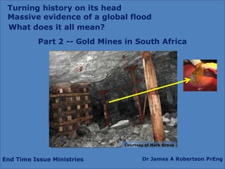
- 1. Turning history on its head Massive evidence of a global flood What does it all mean? Part 2 -- Gold Mines in South Africa Courtesy of Mark Grave End Time Issue Ministries Dr James A Robertson PrEng
- 3. Gold mining, a precision industry
- 4. Gold mining, massive machinery,energy, force
- 6. Locating the Gold is a major activity with exploration drilling from the surface
- 7. The Gold bearing rock (ore) must be kept separate from the waste rock, dilution is a major cost driver
- 8. The ore is crushed very finely and the gold is extracted chemically with a very precise process
- 9. The gold is then extracted from the chemical mix and smelted in a furnace from which rough gold bars are produced
- 10. Fine gold is extracted and then sold for manufacturing of jewellery, electronic circuitry, etc
- 14. Hard metamorphosed rock Northcliff – vitrified (ceramic) Quartzite – intense heat and pressure Gold mine– vitrified (ceramic) Quartzite – intense heat and pressure
- 15. Dipping at about 30 degrees Horizontally deposited under water but now dipping about thirty degrees How did this Happen?
- 16. Dipping at about 30 degrees
- 18. Gold fieldsDispersed and highly faulted
- 21. i.e. The body of water in which this material was deposited was able to receive the discharge of two (2) kilometers vertical depth of sediment
- 22. And there had to be a source of material for two kilometers of deposition
- 24. NOT a stream deposited formation or delta – the ore bodies are of reasonably uniform thickness and wide extent
- 25. A VERY VERYVERY LARGE SEA
- 26. Widespread uniform deposition implies
- 28. high velocity depositionNile Delta
- 29. Massive depth and extent of waterMassive surface vertical displacement Top of Northcliff 1807 m above sea level > 2 km Sea level Proven Gold Deposits > 5 km Halfway House Granite Dome Molten Rock > 2 km Reef 2 km = 7.4 x Hillbrow Tower 5 km = 18.6 x Hillbrow Tower
- 31. Horizontally deposited but now sloping steeply
- 32. Massive faulting
- 33. Can only result from deposition in water over a large area
- 34. Subject to intense pressure and temperature
- 35. Where did it come from?
Editor's Notes
- Add headgear, gold pour, gold barChange line on midline of stope face to yellow and tie in to gold pour, etc
- Gold jewelleryHeadgearsLocating the oreMining at huge depths with safetyMassive coolingPrecision explosionsChemically extracting the gold from the rockMinute quantities, grams per ton – gold ring against tonnes of oreGold plant – ball mill, etcGoldpourSlimes dams
- Gold jewelleryHeadgearsLocating the oreMining at huge depths with safetyMassive coolingPrecision explosionsChemically extracting the gold from the rockMinute quantities, grams per ton – gold ring against tonnes of oreGold plant – ball mill, etcGoldpourSlimes dams
- Gold jewelleryHeadgearsLocating the oreMining at huge depths with safetyMassive coolingPrecision explosionsChemically extracting the gold from the rockMinute quantities, grams per ton – gold ring against tonnes of oreGold plant – ball mill, etcGoldpourSlimes dams
- Gold jewelleryHeadgearsLocating the oreMining at huge depths with safetyMassive coolingPrecision explosionsChemically extracting the gold from the rockMinute quantities, grams per ton – gold ring against tonnes of oreGold plant – ball mill, etcGoldpourSlimes dams
- Same formation as Northcliff and the Magaliesberg – photos of bothGreat extent, map of gold fieldsCollage of headgears
- Very hard rock – same as Northcliff – suggestion of comparable pressure on formationMetamorphosedPressure and heatRoller compacted concrete damPhotos from my thesis – samples – creation of artificial rock
- Horizontally deposited under water but now dipping at about 30 degrees to the South and the West with Northcliff as a pivot point relative to the mines in the East and South and those on the WestVertical section through a shaft showing dip, tunnels, drives, etc
- Horizontally deposited under water but now dipping at about 30 degrees to the South and the West with Northcliff as a pivot point relative to the mines in the East and South and those on the WestVertical section through a shaft showing dip, tunnels, drives, etc
- Same formation as Northcliff and the Magaliesberg – photos of bothGreat extent, map of gold fieldsCollage of headgears
- Same formation as Northcliff and the Magaliesberg – photos of bothGreat extent, map of gold fieldsCollage of headgears
- Faulting to great depthDeepest shafts to / planned to over 5 km under ground, 3 km below sea levelShow tallest building in Johannesburg and tallest in the world stacked against depth of 5 kmMassive faulting, blocks movedDip varies, Depth variesSections from Geology of South Africa and other sourcesJohannesburg Graben – dolerite dyke
- Rough scale drawing – deduce thickness perpendicular to slope from distances on 1:50,000 or find a direct reference to the thickness of the Witwatersrand system – Mark Grave Stratigraphic column about 2,000 m deep – reaches to below sea level and then the deepest ore body is about 6 km underground, 4 km below sea level and the deepest mine is close to 4 km deep, about 2,000 m below sea levelDiagram
- Massive hydraulic actionVery large body of waterNo evidence of delta’s (show Nile or Red Sea – from Google Earth) – diagram of advancing slopeNo evidence of edge of the inland seaMore sedimentary rocks hundreds and even thousands of miles awayMassive tectonic action accompanying the massive hydraulic actionAny explanation must deal precisely with what the miners have foundLook for references to signs of human artefacts in South African mines