SlideShare a Scribd company logo
1 of 9
Download to read offline
1
INRODUCTION
A coastline or seashore is the area where land meets the sea or ocean. Coastal erosion is the
wearing a way of land and the removal of beach or dune sediments by wave action, tidal currents,
wave currents, or drainage.
Every land mass on Earth has miles of coast at the interface between the hydrosphere
and the lithosphere. Natural forces such as wind, waves and currents are constantly shaping the
coastal regions. The combined energy of these forces moves land materials.
The landward displacement of the shoreline caused by the forces of waves and currents
is termed as coastal erosion. It is the loss of sub-aerial landmass into a sea or lake due to natural
processes such as waves, winds and tides, or even due to human interference. While the effects of
waves, currents, tides and wind are primary natural factors that influence the coast the other aspects
eroding the coastline include: the sand sources and sinks, changes in relative sea level,
geomorphological characteristics of the shore and sand, etc. Other anthropological effects that
trigger beach erosion are: construction of artificial structures, mining of beach sand, offshore
dredging, or building of dams or rivers.
SHORELINE
A shore or shoreline is the fringe of land at the edge of a larger body of water, such as an ocean,
sea, or lake.
COASTEL CLASSIFICATION
PRIMARY COAST
Primery coast is coast whitch is essentially in same condition when sea level stabilized after the
last ice age. Primary coast are young coast. Terrestrial (land) influence dominate primary coast
 LAND EROSION COAST
 SUBARIAL DEPOSITION COAST
 VOLCANIC COAST
 ICE COAST
SECONDERY COAST
Secondary coast shaped primarily by marine agents or by marine organism. May or may not have
been primary coast before being shaped by the sea
 Wave erosion coast
 Marine deposition coasts
 Coast build by organism
EROSIONAL AND DEPOSITIONAL COAST
Depending on whether their primary features were created by erosion of land or deposition
of eroded material.
 EROSIONAL COASTS are those that developed where active erosion by wave action
occurs or where rivers or glaciers caused erosion when sea level was lower than it presently
is; these include cliffs or rocky shores
 DEPOSITIONAL COASTS develop where sediments accumulate either from a local source
or after being transported to the area in rivers and glaciers or by ocean currents and waves;
these include deltas, mangrove swamps, salt marshes, barrier islands, and beach-sand dunes
2
A beach is a landform along the shoreline of an ocean, sea, lake or river. It usually consists of loose
particles which are often composed of rock, such as sand, gravel, shingle, pebbles or cobblestones
BEACH
A beach is a landform along the shoreline of an ocean, sea, lake or river. It usually consists of
loose particles which are often composed of rock, such as sand, gravel, shingle, pebbles or
cobblestones
TYPES OF BEACHES
Tropical Beaches
 Formed of fine sand brought to coast by rivers
 Beach rock - cemented sand with calcium carbonate from dissolved shells
Storm Beaches
 At highest point of beach
 Pebbly and steep slope
 Pebbles moved by storm waves
Barrier Beaches
 Elongated sand or pebble banks lying parallel to, but separate from the coastline.
WAVES
Shorelines are dynamic systems involving the energy of waves and currents. Wind-generated
waves provide most of the energy for erosion, transportation, and deposition of sediment. Waves
approaching a shore are bent, or refracted, so that energy is concentrated on headlands and dispersed
in bays.
TIDES
Tidal Tides are produced by the gravitational attraction of the Moon and the centrifugal force of
the Earth–Moon system. They affect coasts in two major ways:
(1) By initiating a rise and fall of the water level and
(2) By generating currents.
OCEAN CURRENTS
An ocean current is a continuous, directed movement of ocean water generated by the forces
acting upon this mean
flow, such as breaking
waves, wind, Carioles
effect, caballing, tempera
ture and salinity
salinity differences
and tides caused by the
gravitational pull of
the Moon and the Sun.
DEPOSITION
Material that is
transported by the waves
along a coastline is
eventually deposited
3
forming distinctive deposition features. There are four main deposition features that you need to
learn the formation of. These are:
1.Beaches
2.Spits
3.Bars
4. Tombolos
LANDFORM CAUSED BY COASTEL EROSION
 BAY
 LAGOON
 SPITS
 BARRIER ISLAND
 TOMBOLO
 PENINSULA
SPITS
Spits are long narrow
ridges of sand and shingle which
project from the coastline into
the sea. The formation of a spit
begins due to a change in the direction of a coastline - the main source of material building up a spit
is from long shore drift which brings
material from further down the coast.
TOMBOLOS
Tombolos are formed where a
spit continues to grow outwards joining
land to an offshore island
BAY
A bay is an area of water mostly
surrounded by land. Bays generally
have calmer waters than the surrounding
sea, due to the surrounding land
blocking some waves and often
reducing winds.
BARRIER ISLAND
Barrier Islands, a coastal landform and a type of barrier system, are relatively narrow strips of
sand that parallel the mainland coast. They usually occur in chains, consisting of anything from a few
islands to more than a dozen
PENINSULA
Peninsula is a piece of land that is bordered by water on three sides but connected to mainland
COASTEL DYNAMICS
Coastal dynamic is the change or movement of coast. Costal dynamics includes erosion,
transportation & deposition by waves, tides, currents, Currents, waves and winds constantly affect
the margins of land adjacent to bodies of water. These processes differ along the various types of
4
coasts and in diverse climates. Coasts are composed of many kinds of materials, including sand,
rocky sediments, mud and biological substances. Because of these variations, coasts respond
differently to the natural forces acting upon them.
In this section deals more about the ways that coasts change and the events that affect them.
Although coasts are unique, all types of coastlines change over time in significant ways.
EROSION
Erosion is the process by which materials are removed from the surface and transported to another
location. Coastal erosion is the wearing of land and the removal of beach or dune sediments by wave
action, tidal current wave currents.
RATE OF DESTRUCTION
Habitat Destruction along the coast and in the ocean results from harmful fishing practices
such as trawling or dynamite fishing , poor land use practices in agricultural, coastal development
and forestry sectors and other human activities such as mining and anchoring. Destroyed habitats
include sea grasses, marshes, corals and mangroves – all of which are important nurseries for fish
and critical for buffering coasts from storm damage. Damaging habitat can lead to increased erosion
and sedimentation, increased impact from storms, fewer nursery grounds and fewer places for
animals and plants to live.
Rate of destruction (weathering) along the coast is due to human activity and also due to natural
agencies. Rate of destruction is not uniform in all coasts. Rate of destruction is controlled by several
factors that are
1. Slope of the coast
2. Intensity of waves tides
3. Wind velocity
4. Topography of coast (sandy, rocky, etc)
RATE OF DESTRUCTION AT DIFFERENT LOCATION IN INDIA
Long shore sediment transport rate (LSTR) reported for different locations along the Indian
coast shows local reversals in the transport direction in a number of locations along the west coast. It
was found that the annual gross sediment transport rate was high along the coast of south Orissa and
south Kerala.
Coastal Erosion in India
The Indian coastline is about 7517 km, about 5423 km along the mainland and2094 km the Andaman
and Nicobar, and Lakshadweep Islands. The coastline comprises of headlands, promontories,
rocky shores, sandy spits, barrier beaches, open beaches, embayment, estuaries, inlets, bays,
marshy land and offshore islands. According to the naval hydrographic charts, the Indian mainland
consists of nearly 43% sandy beaches, 11% rocky coast with cliffs and
46% mud flats and marshy coast. Oscillation of the shoreline along the Indian coast is seasonal.
Some of the beaches regain their original profiles by March/April. Fifty per cent of the beaches that
do not regain their original shape
Over an annual cycle undergo net erosion. Shoreline erosion in the northern regions of Chennai,
Encore, and Visakhapatnam and Para dip ports has resulted duet construction of breakwaters of the
respective port. At present, about 23% of
Shoreline along the Indian main land is affected by erosion.
Erosion Process:
5
Waves start by attacking the main points of weakness in the rock such as the joints and any fault that
there may be in the rock. The point of weakness is increased until it becomes a cave. The waves
continue to attack the cave, which finally results in an arch being formed through the headland. The
arch is then attacked by both coastal and sub - aerial erosion and finally the roof of the arch falls into
the sea. This then leaves behind a stack, which is then slowly eroded down to become a stump.
Low outcrop of rock formed by the erosion of a coastal stack. Unlike a stack, which is exposed at all
times, a stump is exposed only at low tide. Eventually it is worn away completely.
The easiest way of describing the overall effect of coastal erosion is that, if left unchecked, all the
coastlines would be, low wave cut platforms. Most erosion
Takes place around high tide and will be carried out in one of three ways. The first is Hydraulic
erosion which has an effect of a small explosive charge. The sudden impact of a wave on to the cliff
face forces air into any cracks that they might be or along the bedding planes, compressing the air
briefly then releasing the pressure. The changes in pressure causes the cracks to widen and go further
into the cliff, material breaks away and washed out of the cliff by following waves. The material
washed away becomes means for further erosion. The debris is washed against the base of the cliff in
a process known as corrosion and acts in a grinding motion. In this process, not only does erosion
take place at the foot of the cliff but the sediment itself is worn down and rounded in a process
known as attrition. The third type of erosion is chemical, particularly in limestone and chalk cliffs
where chemicals within the sea water attack the rocks eroding the weaker sections and gradually
causing the cliff to collapse.
Coastal lands may experience long-term erosion under some conditions. For instance, if sea level is
rising, the beach may eventually migrate landward or drown. This causes coastal land behind the
beach to erode. Also, if the amount of sand from the seaward side is reduced, a beach will erode the
land behind it to maintain a constant sand supply. This creates a condition called coastal erosion.
Beaches on eroding coasts undergo seasonal profile adjustments, but they slowly shift their position
landward as the land erodes. Hardening a shoreline can interfere with necessary profile adjustments
because the dune can no longer share its sand with the beach. As a retreating beach encounters a
seawall or revetment it can no longer draw upon a landward sand supply and it begins to Waves start
by attacking the main points of weakness in the rock such as the joints and any faults that there may
be in the rock. The point of weakness is increased until it becomes a cave. The waves continue to
attack the cave, which finally results in an arch being formed through the headland. The arch is then
attacked by both coastal and sub - aerial erosion and finally the roof of the arch falls into the sea.
This then leaves behind a stack, which is then slowly eroded down to become a stump.
Low outcrop of rock formed by the erosion of a coastal stack. Unlike a stack, which is exposed at all
times, a stump is exposed only at low tide. Eventually it is worn away completely.
The easiest way of describing the overall effect of coastal erosion is that, if left unchecked, all the
coastlines would be, low wave cut platforms. Most erosion
Takes place around high tide and will be carried out in one of three ways. The first is Hydraulic
erosion which has an effect of a small explosive charge. The sudden impact of a wave on to the cliff
face forces air into any cracks that they might be or along the bedding planes, compressing the air
briefly then releasing the pressure. The changes in pressure causes the cracks to widen and go further
into the cliff, material breaks away and washed out of the cliff by following waves. The material
washed away becomes means for further erosion. The debris is washed against the base of the cliff in
a process known as corrosion and acts in a grinding motion. In this process, not only does erosion
take place at the foot of the cliff but the sediment itself is worn down and rounded in a process
6
known as attrition. The third type of erosion is chemical, particularly in limestone and chalk cliffs
where chemicals within the sea water attack the rocks eroding the weaker sections and gradually
causing the cliff to collapse.
Coastal lands may experience long-term erosion under some conditions. For instance, if sea level is
rising, the beach may eventually migrate landward or drown. This causes coastal land behind the
beach to erode. Also, if the amount of sand from the seaward side is reduced, a beach will erode the
land behind it to maintain a constant sand supply. This creates a condition called coastal erosion.
Beaches on eroding coasts undergo seasonal profile adjustments, but they slowly shift their position
landward as the land erodes. Hardening a shoreline can interfere with necessary profile adjustments
because the dune can no longer share its sand with the beach. As a retreating beach encounters a
seawall or revetment it can no longer draw upon a landward sand supply and it begins erode.
Erosion Rate:
Erosion rates vary over time and space. These variations occur in response to many factors.
Among them are: soil slope and composition
• Credibility of material
• Near shore seabed shoals and slopes
• Storm wave energy and duration
• Precipitation
• Ground water and soil conditions
• Ice cover
• Shoreline orientation
• Beach composition, width and slope
• shore protection structures
It has been observed that sea level rise of 1 mm per year could cause a recession of shoreline in the
order of about 0.5 m per year.
Effects of Coastal Erosion
Coastal erosion, or coastal instability, threatens property and businesses and puts people living
near cliffs and shoreline risk. The great concentration of national resources in coastal zones makes it
imperative that coastal change is well understood.
LANDSLIDES:
The term landslide refers to the downward movement of masses of rock and soil. Landslides are
caused by one or a combination of the following factors: change in slope gradient, increasing the
load the land must bear, shocks and vibrations, change in water content, ground water movement,
frost action, weathering of shocks, removal or, changing the type of vegetation covering slopes.
Landslide hazard areas occur where the land has certain characteristics which contribute to the risk
of the downhill movement of material. These characteristics include:
I A slope greater than 15 percent.
ii Landslide activity or movement occurred during the last 10,000 years.
iii Stream or wave activity which has caused erosion, undercut a bank or cut into a bank to cause the
surrounding land to be unstable.
iv The presence or potential for snow avalanches.
v The presence of an alluvial fan which indicates vulnerability to the flow of debris or sediments.
7
vi The presence of impermeable soils, such as silt or clay, which aremixed with granular soils such
as sand and gravel.
Landslides can also be triggered by other natural hazards such as rains, floods, earthquakes, as well
as human-made causes, such as grading, terrain cutting and filling, excessive development, etc.
Because the factors affecting landslides can be geophysical or human-made, they can occur in
developed areas, undeveloped areas, or any area where the terrain has been altered for roads, houses,
utilities, buildings, etc.
TYPES OF DISASTER:
Natural
 cyclone
,hurricane,
typhoon
 earthquakes
 tsunamis
 landslides
 storms
 floods
Man made
 an airplane
crash,
 a major fire,
 oil spill,
 epidemic,
 terrorism, etc.
Causes of landslides:
 There are
several causes of landslide. Some of the major causes are as follows:
 1. Geological Weak material: Weakness in the composition and structure of rock or soil may
also cause landslides.
 2. Erosion: Erosion of slope toe due to cutting down of vegetation, construction of roads
might increase the vulnerability of the terrain to slide down.
 3. Intense rainfall: Storms that produce intense rainfall for periods as short as several hours or
have a more moderate intensity lasting several days have triggered abundant landslides.
Heavy melting of snow in the hilly terrains also results in landslide.
 Human Excavation of slope and its toe, loading of slope/toe, draw down in reservoir, mining,
deforestation, irrigation, vibration/blast, Water leakage from s
 5. Earthquake shaking has triggered landslides in many different topographic and geologic
settings. Rock falls, soil slides and rockslides rom steep slopes involving relatively thin or
shallow dis-aggregated soils or rock, or both have been the most abundant types of landslides
triggered by historical earthquakes.
 6. Volcanic eruption Deposition of loose volcanic ash on hillsides commonly is followed by
accelerated erosion and frequent mud or debris flows triggered by intense rainfall.
Disaster management:
Is a systematic process (i.e., is based on the key
management principles of planning, organising, and leading which includes coordinating and
Controlling).
8
Aims to reduce the negative impact or consequences of adverse events (i.e., disasters cannot always
be prevented, but the adverse effects can be minimised.
Adverse Effects:
 The most common elements at risk are the settlements built on the steep slopes, built at the
toe and those built at the mouth of the streams emerging from the mountain valley. All those
buildings constructed without appropriate foundation for a given soil and in sloppy areas are
also at risk.Roads, communication lines are vulnerable.
Disaster management cycle:
Steps in disaster management of landslides:
 Pre-disaster studies
 Post disaster
PRE-DISASTER STUDIES:
 Includes landslide hazards zonation mapping are the different parts of the country
 Assessment of the slope stability aspects at the sites of different infra structural facilities
 Landslide hazards zonation on macro (1:50000 or 1:25000 scale) and meso ( 1:10000 or 1:
5000 scale ) has been taken y the geological survey of India.
 Efforts are made to use GIS and data mapping tools are made
 Landslides zonation mapping in parts of Ravi Basin, Himachal Pradesh, Yamuna Basin
Uttrakhand, Imphal, Manipur, Kohima, Nagaland, Cachar , Mezoram,
 Landslides hazard zonation in macro scale includes Guwahati Assam , Kannur
area Idukki Kerala Nilagiri Tamilnadu .
POST DISASTER STUDIES:
 The landslides information reporting preformed was developed for reporting Occurrence
landslides to the DMS Control room GSI New Delhi
 Landslide pre study include reconnoiter studies followed y detailed analysis, preliminary
monitoring of a few landslides and efforts to stabilize the disasters landslides
 The preliminary/ reconnoiter studies of specific slides were carried out – to asses the
magnitude, suggest remedies and identified slides that required detail study
 The work carried out included 34 incidents in HP 65 in Uttarakand, 20 in Jammu Kashmir ,
111 in West Bengal , 4 in Guwahati –
Assam, 6 in Manipur
Possible risk reduction measures:
 Hazard mapping locates areas prone
to slope failures. This will help to
avoid building settlements in such
areas. These maps will also serve as a
tool for mitigation planning.
 Land use practices such as:
 Areas covered by degraded
natural vegetation in upper
slopes are to be afforested with
suitable species.
 Any developmental activity
initiated in the area should be
taken up only after a detailed
9
study of the region has been carried out.
 In construction of roads, irrigation canals etc. proper care is to be taken to avoid
blockage of natural drainage
 Total avoidance of settlement in the risk zone should be made mandatory.
 Relocate settlements and infrastructure that fall in the possible path of the landslide
 No construction of buildings in areas beyond a certain degree of slope
 Retaining Walls can be built to stop landfrom slipping (these walls are commonly seen along
roads in hill stations). These are constructed to prevent smaller sized and secondary
landslides that often occur along the toe portion of the larger landslides.

More Related Content

What's hot (20)

Coastal Erosion And Its Control
Coastal Erosion And Its ControlCoastal Erosion And Its Control
Coastal Erosion And Its Control
 
Distribution of water resources
Distribution of water resourcesDistribution of water resources
Distribution of water resources
 
Tsunami
TsunamiTsunami
Tsunami
 
Tsunami powerpoint
Tsunami  powerpointTsunami  powerpoint
Tsunami powerpoint
 
Coastal Landforms
Coastal  LandformsCoastal  Landforms
Coastal Landforms
 
Ocean circulation
Ocean circulationOcean circulation
Ocean circulation
 
Earthquake
EarthquakeEarthquake
Earthquake
 
Coastal protection
Coastal protectionCoastal protection
Coastal protection
 
Presentaion on natural hazards
Presentaion on natural hazardsPresentaion on natural hazards
Presentaion on natural hazards
 
Coastal erosion
Coastal erosionCoastal erosion
Coastal erosion
 
Coastal processes and landforms
Coastal processes and landformsCoastal processes and landforms
Coastal processes and landforms
 
Gravity Method | Geophysics | Geology
Gravity Method | Geophysics | GeologyGravity Method | Geophysics | Geology
Gravity Method | Geophysics | Geology
 
Vertical distribution of groundwater
Vertical distribution of groundwaterVertical distribution of groundwater
Vertical distribution of groundwater
 
Coastal Erosion Notes
Coastal Erosion NotesCoastal Erosion Notes
Coastal Erosion Notes
 
Fluvial landforms
Fluvial landformsFluvial landforms
Fluvial landforms
 
Coastal Process of Erosion and Deposition
Coastal Process of Erosion and DepositionCoastal Process of Erosion and Deposition
Coastal Process of Erosion and Deposition
 
Tsunami
Tsunami Tsunami
Tsunami
 
Coastal Morphology
Coastal MorphologyCoastal Morphology
Coastal Morphology
 
Ocean motion
Ocean motionOcean motion
Ocean motion
 
Coral reefs
Coral reefsCoral reefs
Coral reefs
 

Similar to Coastal erosion and engineering aspect

COASTS ENM 142 Lecture 7.pptx
COASTS ENM 142 Lecture 7.pptxCOASTS ENM 142 Lecture 7.pptx
COASTS ENM 142 Lecture 7.pptxCheDillon1
 
Coastal Oceanography Notes
Coastal Oceanography NotesCoastal Oceanography Notes
Coastal Oceanography NotesMdIbrahim461538
 
Coastal land-form evoltion
Coastal land-form evoltionCoastal land-form evoltion
Coastal land-form evoltionsalahudintanoli
 
Marine Systems
Marine SystemsMarine Systems
Marine Systemsshoaib1982
 
COASTAL LANDFORMS.pptx
COASTAL LANDFORMS.pptxCOASTAL LANDFORMS.pptx
COASTAL LANDFORMS.pptxKuki Boruah
 
CAMBRIDGE GEOGRAPHY A2 REVISION - COASTAL ENVIRONMENTS: 8.1 WAVES MARINE AND ...
CAMBRIDGE GEOGRAPHY A2 REVISION - COASTAL ENVIRONMENTS: 8.1 WAVES MARINE AND ...CAMBRIDGE GEOGRAPHY A2 REVISION - COASTAL ENVIRONMENTS: 8.1 WAVES MARINE AND ...
CAMBRIDGE GEOGRAPHY A2 REVISION - COASTAL ENVIRONMENTS: 8.1 WAVES MARINE AND ...George Dumitrache
 
Coastal Processes handout
Coastal Processes handoutCoastal Processes handout
Coastal Processes handoutKayceeJ
 
Formation of coastline
Formation of coastlineFormation of coastline
Formation of coastlinePathan Farhan
 
Coastal Geomorphology Landforms Of Wave Erosion & Deposition
Coastal Geomorphology Landforms Of Wave Erosion & DepositionCoastal Geomorphology Landforms Of Wave Erosion & Deposition
Coastal Geomorphology Landforms Of Wave Erosion & DepositionPRasad PK
 
Coastal erosion cliffs etc
Coastal erosion cliffs etcCoastal erosion cliffs etc
Coastal erosion cliffs etcWill Williams
 
Coastal erosion(final presentation)
Coastal erosion(final presentation)Coastal erosion(final presentation)
Coastal erosion(final presentation)Vampire Secret
 
Coastal Processes And Landforms
Coastal Processes And LandformsCoastal Processes And Landforms
Coastal Processes And LandformsMalia Damit
 
CAMBRIDGE GEOGRAPHY A2 REVISION - COASTAL ENVIRONMENTS: 8.2 COASTAL LANDFORMS...
CAMBRIDGE GEOGRAPHY A2 REVISION - COASTAL ENVIRONMENTS: 8.2 COASTAL LANDFORMS...CAMBRIDGE GEOGRAPHY A2 REVISION - COASTAL ENVIRONMENTS: 8.2 COASTAL LANDFORMS...
CAMBRIDGE GEOGRAPHY A2 REVISION - COASTAL ENVIRONMENTS: 8.2 COASTAL LANDFORMS...George Dumitrache
 

Similar to Coastal erosion and engineering aspect (20)

COASTS ENM 142 Lecture 7.pptx
COASTS ENM 142 Lecture 7.pptxCOASTS ENM 142 Lecture 7.pptx
COASTS ENM 142 Lecture 7.pptx
 
Coastal Oceanography Notes
Coastal Oceanography NotesCoastal Oceanography Notes
Coastal Oceanography Notes
 
Coastal and sea erosion
Coastal and sea erosionCoastal and sea erosion
Coastal and sea erosion
 
Coastlines.pptx
Coastlines.pptxCoastlines.pptx
Coastlines.pptx
 
ppt coastal.pptx
ppt coastal.pptxppt coastal.pptx
ppt coastal.pptx
 
Coastal land-form evoltion
Coastal land-form evoltionCoastal land-form evoltion
Coastal land-form evoltion
 
Marine Systems
Marine SystemsMarine Systems
Marine Systems
 
COASTAL LANDFORMS.pptx
COASTAL LANDFORMS.pptxCOASTAL LANDFORMS.pptx
COASTAL LANDFORMS.pptx
 
CAMBRIDGE GEOGRAPHY A2 REVISION - COASTAL ENVIRONMENTS: 8.1 WAVES MARINE AND ...
CAMBRIDGE GEOGRAPHY A2 REVISION - COASTAL ENVIRONMENTS: 8.1 WAVES MARINE AND ...CAMBRIDGE GEOGRAPHY A2 REVISION - COASTAL ENVIRONMENTS: 8.1 WAVES MARINE AND ...
CAMBRIDGE GEOGRAPHY A2 REVISION - COASTAL ENVIRONMENTS: 8.1 WAVES MARINE AND ...
 
3 e coasts (1)
3 e coasts (1)3 e coasts (1)
3 e coasts (1)
 
Costal landforms
Costal landforms Costal landforms
Costal landforms
 
Coastal Processes handout
Coastal Processes handoutCoastal Processes handout
Coastal Processes handout
 
Formation of coastline
Formation of coastlineFormation of coastline
Formation of coastline
 
Coastal Geomorphology Landforms Of Wave Erosion & Deposition
Coastal Geomorphology Landforms Of Wave Erosion & DepositionCoastal Geomorphology Landforms Of Wave Erosion & Deposition
Coastal Geomorphology Landforms Of Wave Erosion & Deposition
 
Coastal erosion cliffs etc
Coastal erosion cliffs etcCoastal erosion cliffs etc
Coastal erosion cliffs etc
 
Coadstal Landforms
Coadstal LandformsCoadstal Landforms
Coadstal Landforms
 
Coastal erosion(final presentation)
Coastal erosion(final presentation)Coastal erosion(final presentation)
Coastal erosion(final presentation)
 
Coastal Processes And Landforms
Coastal Processes And LandformsCoastal Processes And Landforms
Coastal Processes And Landforms
 
CAMBRIDGE GEOGRAPHY A2 REVISION - COASTAL ENVIRONMENTS: 8.2 COASTAL LANDFORMS...
CAMBRIDGE GEOGRAPHY A2 REVISION - COASTAL ENVIRONMENTS: 8.2 COASTAL LANDFORMS...CAMBRIDGE GEOGRAPHY A2 REVISION - COASTAL ENVIRONMENTS: 8.2 COASTAL LANDFORMS...
CAMBRIDGE GEOGRAPHY A2 REVISION - COASTAL ENVIRONMENTS: 8.2 COASTAL LANDFORMS...
 
Coastal Land form
Coastal Land form Coastal Land form
Coastal Land form
 

More from Pramoda Raj

Aerial photography.pptx
Aerial photography.pptxAerial photography.pptx
Aerial photography.pptxPramoda Raj
 
Siwalik- Stratigraphy
Siwalik- StratigraphySiwalik- Stratigraphy
Siwalik- StratigraphyPramoda Raj
 
Waves and their significance
Waves and their significanceWaves and their significance
Waves and their significancePramoda Raj
 
Karst topography
Karst topographyKarst topography
Karst topographyPramoda Raj
 
Glacial processes and their land forms.
Glacial processes and their land forms.Glacial processes and their land forms.
Glacial processes and their land forms.Pramoda Raj
 
Upsc geologist syllabus exam pattern
Upsc geologist syllabus exam patternUpsc geologist syllabus exam pattern
Upsc geologist syllabus exam patternPramoda Raj
 
Role of non government organizations in disaster management
Role of non government organizations in disaster managementRole of non government organizations in disaster management
Role of non government organizations in disaster managementPramoda Raj
 
Disaster Management System in India - Notes
Disaster Management System in India - Notes Disaster Management System in India - Notes
Disaster Management System in India - Notes Pramoda Raj
 
Role of non government organizations in disaster management
Role of non government organizations in disaster managementRole of non government organizations in disaster management
Role of non government organizations in disaster managementPramoda Raj
 
Disaster management system in India
Disaster management system in IndiaDisaster management system in India
Disaster management system in IndiaPramoda Raj
 
International organizations in disaster management
International organizations in disaster managementInternational organizations in disaster management
International organizations in disaster managementPramoda Raj
 
Geological factor for canal alignment
Geological factor for canal alignmentGeological factor for canal alignment
Geological factor for canal alignmentPramoda Raj
 
Major extinction events
Major extinction eventsMajor extinction events
Major extinction eventsPramoda Raj
 
Sampling techniques
Sampling techniquesSampling techniques
Sampling techniquesPramoda Raj
 
National mineral policy - 2018
National mineral policy - 2018National mineral policy - 2018
National mineral policy - 2018Pramoda Raj
 

More from Pramoda Raj (20)

Aerial photography.pptx
Aerial photography.pptxAerial photography.pptx
Aerial photography.pptx
 
Siwalik- Stratigraphy
Siwalik- StratigraphySiwalik- Stratigraphy
Siwalik- Stratigraphy
 
Hydrogeology
HydrogeologyHydrogeology
Hydrogeology
 
Waves and their significance
Waves and their significanceWaves and their significance
Waves and their significance
 
Karst topography
Karst topographyKarst topography
Karst topography
 
Glacial processes and their land forms.
Glacial processes and their land forms.Glacial processes and their land forms.
Glacial processes and their land forms.
 
Dams
Dams Dams
Dams
 
Upsc geologist syllabus exam pattern
Upsc geologist syllabus exam patternUpsc geologist syllabus exam pattern
Upsc geologist syllabus exam pattern
 
Role of non government organizations in disaster management
Role of non government organizations in disaster managementRole of non government organizations in disaster management
Role of non government organizations in disaster management
 
Disaster Management System in India - Notes
Disaster Management System in India - Notes Disaster Management System in India - Notes
Disaster Management System in India - Notes
 
Role of non government organizations in disaster management
Role of non government organizations in disaster managementRole of non government organizations in disaster management
Role of non government organizations in disaster management
 
Disaster management system in India
Disaster management system in IndiaDisaster management system in India
Disaster management system in India
 
International organizations in disaster management
International organizations in disaster managementInternational organizations in disaster management
International organizations in disaster management
 
Geological factor for canal alignment
Geological factor for canal alignmentGeological factor for canal alignment
Geological factor for canal alignment
 
Major extinction events
Major extinction eventsMajor extinction events
Major extinction events
 
Geotextiles
GeotextilesGeotextiles
Geotextiles
 
Hazard mapping
Hazard mappingHazard mapping
Hazard mapping
 
Sampling techniques
Sampling techniquesSampling techniques
Sampling techniques
 
Faults
FaultsFaults
Faults
 
National mineral policy - 2018
National mineral policy - 2018National mineral policy - 2018
National mineral policy - 2018
 

Recently uploaded

Framing an Appropriate Research Question 6b9b26d93da94caf993c038d9efcdedb.pdf
Framing an Appropriate Research Question 6b9b26d93da94caf993c038d9efcdedb.pdfFraming an Appropriate Research Question 6b9b26d93da94caf993c038d9efcdedb.pdf
Framing an Appropriate Research Question 6b9b26d93da94caf993c038d9efcdedb.pdfUjwalaBharambe
 
Judging the Relevance and worth of ideas part 2.pptx
Judging the Relevance  and worth of ideas part 2.pptxJudging the Relevance  and worth of ideas part 2.pptx
Judging the Relevance and worth of ideas part 2.pptxSherlyMaeNeri
 
EPANDING THE CONTENT OF AN OUTLINE using notes.pptx
EPANDING THE CONTENT OF AN OUTLINE using notes.pptxEPANDING THE CONTENT OF AN OUTLINE using notes.pptx
EPANDING THE CONTENT OF AN OUTLINE using notes.pptxRaymartEstabillo3
 
ENGLISH6-Q4-W3.pptxqurter our high choom
ENGLISH6-Q4-W3.pptxqurter our high choomENGLISH6-Q4-W3.pptxqurter our high choom
ENGLISH6-Q4-W3.pptxqurter our high choomnelietumpap1
 
Influencing policy (training slides from Fast Track Impact)
Influencing policy (training slides from Fast Track Impact)Influencing policy (training slides from Fast Track Impact)
Influencing policy (training slides from Fast Track Impact)Mark Reed
 
Gas measurement O2,Co2,& ph) 04/2024.pptx
Gas measurement O2,Co2,& ph) 04/2024.pptxGas measurement O2,Co2,& ph) 04/2024.pptx
Gas measurement O2,Co2,& ph) 04/2024.pptxDr.Ibrahim Hassaan
 
AMERICAN LANGUAGE HUB_Level2_Student'sBook_Answerkey.pdf
AMERICAN LANGUAGE HUB_Level2_Student'sBook_Answerkey.pdfAMERICAN LANGUAGE HUB_Level2_Student'sBook_Answerkey.pdf
AMERICAN LANGUAGE HUB_Level2_Student'sBook_Answerkey.pdfphamnguyenenglishnb
 
Crayon Activity Handout For the Crayon A
Crayon Activity Handout For the Crayon ACrayon Activity Handout For the Crayon A
Crayon Activity Handout For the Crayon AUnboundStockton
 
ECONOMIC CONTEXT - LONG FORM TV DRAMA - PPT
ECONOMIC CONTEXT - LONG FORM TV DRAMA - PPTECONOMIC CONTEXT - LONG FORM TV DRAMA - PPT
ECONOMIC CONTEXT - LONG FORM TV DRAMA - PPTiammrhaywood
 
Planning a health career 4th Quarter.pptx
Planning a health career 4th Quarter.pptxPlanning a health career 4th Quarter.pptx
Planning a health career 4th Quarter.pptxLigayaBacuel1
 
Difference Between Search & Browse Methods in Odoo 17
Difference Between Search & Browse Methods in Odoo 17Difference Between Search & Browse Methods in Odoo 17
Difference Between Search & Browse Methods in Odoo 17Celine George
 
Proudly South Africa powerpoint Thorisha.pptx
Proudly South Africa powerpoint Thorisha.pptxProudly South Africa powerpoint Thorisha.pptx
Proudly South Africa powerpoint Thorisha.pptxthorishapillay1
 
ROOT CAUSE ANALYSIS PowerPoint Presentation
ROOT CAUSE ANALYSIS PowerPoint PresentationROOT CAUSE ANALYSIS PowerPoint Presentation
ROOT CAUSE ANALYSIS PowerPoint PresentationAadityaSharma884161
 
Earth Day Presentation wow hello nice great
Earth Day Presentation wow hello nice greatEarth Day Presentation wow hello nice great
Earth Day Presentation wow hello nice greatYousafMalik24
 
call girls in Kamla Market (DELHI) 🔝 >༒9953330565🔝 genuine Escort Service 🔝✔️✔️
call girls in Kamla Market (DELHI) 🔝 >༒9953330565🔝 genuine Escort Service 🔝✔️✔️call girls in Kamla Market (DELHI) 🔝 >༒9953330565🔝 genuine Escort Service 🔝✔️✔️
call girls in Kamla Market (DELHI) 🔝 >༒9953330565🔝 genuine Escort Service 🔝✔️✔️9953056974 Low Rate Call Girls In Saket, Delhi NCR
 
Full Stack Web Development Course for Beginners
Full Stack Web Development Course  for BeginnersFull Stack Web Development Course  for Beginners
Full Stack Web Development Course for BeginnersSabitha Banu
 
Grade 9 Q4-MELC1-Active and Passive Voice.pptx
Grade 9 Q4-MELC1-Active and Passive Voice.pptxGrade 9 Q4-MELC1-Active and Passive Voice.pptx
Grade 9 Q4-MELC1-Active and Passive Voice.pptxChelloAnnAsuncion2
 

Recently uploaded (20)

Framing an Appropriate Research Question 6b9b26d93da94caf993c038d9efcdedb.pdf
Framing an Appropriate Research Question 6b9b26d93da94caf993c038d9efcdedb.pdfFraming an Appropriate Research Question 6b9b26d93da94caf993c038d9efcdedb.pdf
Framing an Appropriate Research Question 6b9b26d93da94caf993c038d9efcdedb.pdf
 
Judging the Relevance and worth of ideas part 2.pptx
Judging the Relevance  and worth of ideas part 2.pptxJudging the Relevance  and worth of ideas part 2.pptx
Judging the Relevance and worth of ideas part 2.pptx
 
TataKelola dan KamSiber Kecerdasan Buatan v022.pdf
TataKelola dan KamSiber Kecerdasan Buatan v022.pdfTataKelola dan KamSiber Kecerdasan Buatan v022.pdf
TataKelola dan KamSiber Kecerdasan Buatan v022.pdf
 
9953330565 Low Rate Call Girls In Rohini Delhi NCR
9953330565 Low Rate Call Girls In Rohini  Delhi NCR9953330565 Low Rate Call Girls In Rohini  Delhi NCR
9953330565 Low Rate Call Girls In Rohini Delhi NCR
 
EPANDING THE CONTENT OF AN OUTLINE using notes.pptx
EPANDING THE CONTENT OF AN OUTLINE using notes.pptxEPANDING THE CONTENT OF AN OUTLINE using notes.pptx
EPANDING THE CONTENT OF AN OUTLINE using notes.pptx
 
ENGLISH6-Q4-W3.pptxqurter our high choom
ENGLISH6-Q4-W3.pptxqurter our high choomENGLISH6-Q4-W3.pptxqurter our high choom
ENGLISH6-Q4-W3.pptxqurter our high choom
 
Rapple "Scholarly Communications and the Sustainable Development Goals"
Rapple "Scholarly Communications and the Sustainable Development Goals"Rapple "Scholarly Communications and the Sustainable Development Goals"
Rapple "Scholarly Communications and the Sustainable Development Goals"
 
Influencing policy (training slides from Fast Track Impact)
Influencing policy (training slides from Fast Track Impact)Influencing policy (training slides from Fast Track Impact)
Influencing policy (training slides from Fast Track Impact)
 
Gas measurement O2,Co2,& ph) 04/2024.pptx
Gas measurement O2,Co2,& ph) 04/2024.pptxGas measurement O2,Co2,& ph) 04/2024.pptx
Gas measurement O2,Co2,& ph) 04/2024.pptx
 
AMERICAN LANGUAGE HUB_Level2_Student'sBook_Answerkey.pdf
AMERICAN LANGUAGE HUB_Level2_Student'sBook_Answerkey.pdfAMERICAN LANGUAGE HUB_Level2_Student'sBook_Answerkey.pdf
AMERICAN LANGUAGE HUB_Level2_Student'sBook_Answerkey.pdf
 
Crayon Activity Handout For the Crayon A
Crayon Activity Handout For the Crayon ACrayon Activity Handout For the Crayon A
Crayon Activity Handout For the Crayon A
 
ECONOMIC CONTEXT - LONG FORM TV DRAMA - PPT
ECONOMIC CONTEXT - LONG FORM TV DRAMA - PPTECONOMIC CONTEXT - LONG FORM TV DRAMA - PPT
ECONOMIC CONTEXT - LONG FORM TV DRAMA - PPT
 
Planning a health career 4th Quarter.pptx
Planning a health career 4th Quarter.pptxPlanning a health career 4th Quarter.pptx
Planning a health career 4th Quarter.pptx
 
Difference Between Search & Browse Methods in Odoo 17
Difference Between Search & Browse Methods in Odoo 17Difference Between Search & Browse Methods in Odoo 17
Difference Between Search & Browse Methods in Odoo 17
 
Proudly South Africa powerpoint Thorisha.pptx
Proudly South Africa powerpoint Thorisha.pptxProudly South Africa powerpoint Thorisha.pptx
Proudly South Africa powerpoint Thorisha.pptx
 
ROOT CAUSE ANALYSIS PowerPoint Presentation
ROOT CAUSE ANALYSIS PowerPoint PresentationROOT CAUSE ANALYSIS PowerPoint Presentation
ROOT CAUSE ANALYSIS PowerPoint Presentation
 
Earth Day Presentation wow hello nice great
Earth Day Presentation wow hello nice greatEarth Day Presentation wow hello nice great
Earth Day Presentation wow hello nice great
 
call girls in Kamla Market (DELHI) 🔝 >༒9953330565🔝 genuine Escort Service 🔝✔️✔️
call girls in Kamla Market (DELHI) 🔝 >༒9953330565🔝 genuine Escort Service 🔝✔️✔️call girls in Kamla Market (DELHI) 🔝 >༒9953330565🔝 genuine Escort Service 🔝✔️✔️
call girls in Kamla Market (DELHI) 🔝 >༒9953330565🔝 genuine Escort Service 🔝✔️✔️
 
Full Stack Web Development Course for Beginners
Full Stack Web Development Course  for BeginnersFull Stack Web Development Course  for Beginners
Full Stack Web Development Course for Beginners
 
Grade 9 Q4-MELC1-Active and Passive Voice.pptx
Grade 9 Q4-MELC1-Active and Passive Voice.pptxGrade 9 Q4-MELC1-Active and Passive Voice.pptx
Grade 9 Q4-MELC1-Active and Passive Voice.pptx
 

Coastal erosion and engineering aspect

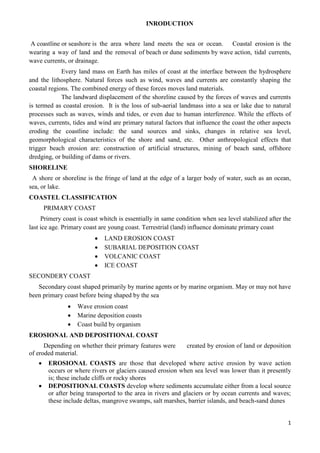
  • 1. 1 INRODUCTION A coastline or seashore is the area where land meets the sea or ocean. Coastal erosion is the wearing a way of land and the removal of beach or dune sediments by wave action, tidal currents, wave currents, or drainage. Every land mass on Earth has miles of coast at the interface between the hydrosphere and the lithosphere. Natural forces such as wind, waves and currents are constantly shaping the coastal regions. The combined energy of these forces moves land materials. The landward displacement of the shoreline caused by the forces of waves and currents is termed as coastal erosion. It is the loss of sub-aerial landmass into a sea or lake due to natural processes such as waves, winds and tides, or even due to human interference. While the effects of waves, currents, tides and wind are primary natural factors that influence the coast the other aspects eroding the coastline include: the sand sources and sinks, changes in relative sea level, geomorphological characteristics of the shore and sand, etc. Other anthropological effects that trigger beach erosion are: construction of artificial structures, mining of beach sand, offshore dredging, or building of dams or rivers. SHORELINE A shore or shoreline is the fringe of land at the edge of a larger body of water, such as an ocean, sea, or lake. COASTEL CLASSIFICATION PRIMARY COAST Primery coast is coast whitch is essentially in same condition when sea level stabilized after the last ice age. Primary coast are young coast. Terrestrial (land) influence dominate primary coast  LAND EROSION COAST  SUBARIAL DEPOSITION COAST  VOLCANIC COAST  ICE COAST SECONDERY COAST Secondary coast shaped primarily by marine agents or by marine organism. May or may not have been primary coast before being shaped by the sea  Wave erosion coast  Marine deposition coasts  Coast build by organism EROSIONAL AND DEPOSITIONAL COAST Depending on whether their primary features were created by erosion of land or deposition of eroded material.  EROSIONAL COASTS are those that developed where active erosion by wave action occurs or where rivers or glaciers caused erosion when sea level was lower than it presently is; these include cliffs or rocky shores  DEPOSITIONAL COASTS develop where sediments accumulate either from a local source or after being transported to the area in rivers and glaciers or by ocean currents and waves; these include deltas, mangrove swamps, salt marshes, barrier islands, and beach-sand dunes
  • 2. 2 A beach is a landform along the shoreline of an ocean, sea, lake or river. It usually consists of loose particles which are often composed of rock, such as sand, gravel, shingle, pebbles or cobblestones BEACH A beach is a landform along the shoreline of an ocean, sea, lake or river. It usually consists of loose particles which are often composed of rock, such as sand, gravel, shingle, pebbles or cobblestones TYPES OF BEACHES Tropical Beaches  Formed of fine sand brought to coast by rivers  Beach rock - cemented sand with calcium carbonate from dissolved shells Storm Beaches  At highest point of beach  Pebbly and steep slope  Pebbles moved by storm waves Barrier Beaches  Elongated sand or pebble banks lying parallel to, but separate from the coastline. WAVES Shorelines are dynamic systems involving the energy of waves and currents. Wind-generated waves provide most of the energy for erosion, transportation, and deposition of sediment. Waves approaching a shore are bent, or refracted, so that energy is concentrated on headlands and dispersed in bays. TIDES Tidal Tides are produced by the gravitational attraction of the Moon and the centrifugal force of the Earth–Moon system. They affect coasts in two major ways: (1) By initiating a rise and fall of the water level and (2) By generating currents. OCEAN CURRENTS An ocean current is a continuous, directed movement of ocean water generated by the forces acting upon this mean flow, such as breaking waves, wind, Carioles effect, caballing, tempera ture and salinity salinity differences and tides caused by the gravitational pull of the Moon and the Sun. DEPOSITION Material that is transported by the waves along a coastline is eventually deposited
  • 3. 3 forming distinctive deposition features. There are four main deposition features that you need to learn the formation of. These are: 1.Beaches 2.Spits 3.Bars 4. Tombolos LANDFORM CAUSED BY COASTEL EROSION  BAY  LAGOON  SPITS  BARRIER ISLAND  TOMBOLO  PENINSULA SPITS Spits are long narrow ridges of sand and shingle which project from the coastline into the sea. The formation of a spit begins due to a change in the direction of a coastline - the main source of material building up a spit is from long shore drift which brings material from further down the coast. TOMBOLOS Tombolos are formed where a spit continues to grow outwards joining land to an offshore island BAY A bay is an area of water mostly surrounded by land. Bays generally have calmer waters than the surrounding sea, due to the surrounding land blocking some waves and often reducing winds. BARRIER ISLAND Barrier Islands, a coastal landform and a type of barrier system, are relatively narrow strips of sand that parallel the mainland coast. They usually occur in chains, consisting of anything from a few islands to more than a dozen PENINSULA Peninsula is a piece of land that is bordered by water on three sides but connected to mainland COASTEL DYNAMICS Coastal dynamic is the change or movement of coast. Costal dynamics includes erosion, transportation & deposition by waves, tides, currents, Currents, waves and winds constantly affect the margins of land adjacent to bodies of water. These processes differ along the various types of
  • 4. 4 coasts and in diverse climates. Coasts are composed of many kinds of materials, including sand, rocky sediments, mud and biological substances. Because of these variations, coasts respond differently to the natural forces acting upon them. In this section deals more about the ways that coasts change and the events that affect them. Although coasts are unique, all types of coastlines change over time in significant ways. EROSION Erosion is the process by which materials are removed from the surface and transported to another location. Coastal erosion is the wearing of land and the removal of beach or dune sediments by wave action, tidal current wave currents. RATE OF DESTRUCTION Habitat Destruction along the coast and in the ocean results from harmful fishing practices such as trawling or dynamite fishing , poor land use practices in agricultural, coastal development and forestry sectors and other human activities such as mining and anchoring. Destroyed habitats include sea grasses, marshes, corals and mangroves – all of which are important nurseries for fish and critical for buffering coasts from storm damage. Damaging habitat can lead to increased erosion and sedimentation, increased impact from storms, fewer nursery grounds and fewer places for animals and plants to live. Rate of destruction (weathering) along the coast is due to human activity and also due to natural agencies. Rate of destruction is not uniform in all coasts. Rate of destruction is controlled by several factors that are 1. Slope of the coast 2. Intensity of waves tides 3. Wind velocity 4. Topography of coast (sandy, rocky, etc) RATE OF DESTRUCTION AT DIFFERENT LOCATION IN INDIA Long shore sediment transport rate (LSTR) reported for different locations along the Indian coast shows local reversals in the transport direction in a number of locations along the west coast. It was found that the annual gross sediment transport rate was high along the coast of south Orissa and south Kerala. Coastal Erosion in India The Indian coastline is about 7517 km, about 5423 km along the mainland and2094 km the Andaman and Nicobar, and Lakshadweep Islands. The coastline comprises of headlands, promontories, rocky shores, sandy spits, barrier beaches, open beaches, embayment, estuaries, inlets, bays, marshy land and offshore islands. According to the naval hydrographic charts, the Indian mainland consists of nearly 43% sandy beaches, 11% rocky coast with cliffs and 46% mud flats and marshy coast. Oscillation of the shoreline along the Indian coast is seasonal. Some of the beaches regain their original profiles by March/April. Fifty per cent of the beaches that do not regain their original shape Over an annual cycle undergo net erosion. Shoreline erosion in the northern regions of Chennai, Encore, and Visakhapatnam and Para dip ports has resulted duet construction of breakwaters of the respective port. At present, about 23% of Shoreline along the Indian main land is affected by erosion. Erosion Process:
  • 5. 5 Waves start by attacking the main points of weakness in the rock such as the joints and any fault that there may be in the rock. The point of weakness is increased until it becomes a cave. The waves continue to attack the cave, which finally results in an arch being formed through the headland. The arch is then attacked by both coastal and sub - aerial erosion and finally the roof of the arch falls into the sea. This then leaves behind a stack, which is then slowly eroded down to become a stump. Low outcrop of rock formed by the erosion of a coastal stack. Unlike a stack, which is exposed at all times, a stump is exposed only at low tide. Eventually it is worn away completely. The easiest way of describing the overall effect of coastal erosion is that, if left unchecked, all the coastlines would be, low wave cut platforms. Most erosion Takes place around high tide and will be carried out in one of three ways. The first is Hydraulic erosion which has an effect of a small explosive charge. The sudden impact of a wave on to the cliff face forces air into any cracks that they might be or along the bedding planes, compressing the air briefly then releasing the pressure. The changes in pressure causes the cracks to widen and go further into the cliff, material breaks away and washed out of the cliff by following waves. The material washed away becomes means for further erosion. The debris is washed against the base of the cliff in a process known as corrosion and acts in a grinding motion. In this process, not only does erosion take place at the foot of the cliff but the sediment itself is worn down and rounded in a process known as attrition. The third type of erosion is chemical, particularly in limestone and chalk cliffs where chemicals within the sea water attack the rocks eroding the weaker sections and gradually causing the cliff to collapse. Coastal lands may experience long-term erosion under some conditions. For instance, if sea level is rising, the beach may eventually migrate landward or drown. This causes coastal land behind the beach to erode. Also, if the amount of sand from the seaward side is reduced, a beach will erode the land behind it to maintain a constant sand supply. This creates a condition called coastal erosion. Beaches on eroding coasts undergo seasonal profile adjustments, but they slowly shift their position landward as the land erodes. Hardening a shoreline can interfere with necessary profile adjustments because the dune can no longer share its sand with the beach. As a retreating beach encounters a seawall or revetment it can no longer draw upon a landward sand supply and it begins to Waves start by attacking the main points of weakness in the rock such as the joints and any faults that there may be in the rock. The point of weakness is increased until it becomes a cave. The waves continue to attack the cave, which finally results in an arch being formed through the headland. The arch is then attacked by both coastal and sub - aerial erosion and finally the roof of the arch falls into the sea. This then leaves behind a stack, which is then slowly eroded down to become a stump. Low outcrop of rock formed by the erosion of a coastal stack. Unlike a stack, which is exposed at all times, a stump is exposed only at low tide. Eventually it is worn away completely. The easiest way of describing the overall effect of coastal erosion is that, if left unchecked, all the coastlines would be, low wave cut platforms. Most erosion Takes place around high tide and will be carried out in one of three ways. The first is Hydraulic erosion which has an effect of a small explosive charge. The sudden impact of a wave on to the cliff face forces air into any cracks that they might be or along the bedding planes, compressing the air briefly then releasing the pressure. The changes in pressure causes the cracks to widen and go further into the cliff, material breaks away and washed out of the cliff by following waves. The material washed away becomes means for further erosion. The debris is washed against the base of the cliff in a process known as corrosion and acts in a grinding motion. In this process, not only does erosion take place at the foot of the cliff but the sediment itself is worn down and rounded in a process
  • 6. 6 known as attrition. The third type of erosion is chemical, particularly in limestone and chalk cliffs where chemicals within the sea water attack the rocks eroding the weaker sections and gradually causing the cliff to collapse. Coastal lands may experience long-term erosion under some conditions. For instance, if sea level is rising, the beach may eventually migrate landward or drown. This causes coastal land behind the beach to erode. Also, if the amount of sand from the seaward side is reduced, a beach will erode the land behind it to maintain a constant sand supply. This creates a condition called coastal erosion. Beaches on eroding coasts undergo seasonal profile adjustments, but they slowly shift their position landward as the land erodes. Hardening a shoreline can interfere with necessary profile adjustments because the dune can no longer share its sand with the beach. As a retreating beach encounters a seawall or revetment it can no longer draw upon a landward sand supply and it begins erode. Erosion Rate: Erosion rates vary over time and space. These variations occur in response to many factors. Among them are: soil slope and composition • Credibility of material • Near shore seabed shoals and slopes • Storm wave energy and duration • Precipitation • Ground water and soil conditions • Ice cover • Shoreline orientation • Beach composition, width and slope • shore protection structures It has been observed that sea level rise of 1 mm per year could cause a recession of shoreline in the order of about 0.5 m per year. Effects of Coastal Erosion Coastal erosion, or coastal instability, threatens property and businesses and puts people living near cliffs and shoreline risk. The great concentration of national resources in coastal zones makes it imperative that coastal change is well understood. LANDSLIDES: The term landslide refers to the downward movement of masses of rock and soil. Landslides are caused by one or a combination of the following factors: change in slope gradient, increasing the load the land must bear, shocks and vibrations, change in water content, ground water movement, frost action, weathering of shocks, removal or, changing the type of vegetation covering slopes. Landslide hazard areas occur where the land has certain characteristics which contribute to the risk of the downhill movement of material. These characteristics include: I A slope greater than 15 percent. ii Landslide activity or movement occurred during the last 10,000 years. iii Stream or wave activity which has caused erosion, undercut a bank or cut into a bank to cause the surrounding land to be unstable. iv The presence or potential for snow avalanches. v The presence of an alluvial fan which indicates vulnerability to the flow of debris or sediments.
  • 7. 7 vi The presence of impermeable soils, such as silt or clay, which aremixed with granular soils such as sand and gravel. Landslides can also be triggered by other natural hazards such as rains, floods, earthquakes, as well as human-made causes, such as grading, terrain cutting and filling, excessive development, etc. Because the factors affecting landslides can be geophysical or human-made, they can occur in developed areas, undeveloped areas, or any area where the terrain has been altered for roads, houses, utilities, buildings, etc. TYPES OF DISASTER: Natural  cyclone ,hurricane, typhoon  earthquakes  tsunamis  landslides  storms  floods Man made  an airplane crash,  a major fire,  oil spill,  epidemic,  terrorism, etc. Causes of landslides:  There are several causes of landslide. Some of the major causes are as follows:  1. Geological Weak material: Weakness in the composition and structure of rock or soil may also cause landslides.  2. Erosion: Erosion of slope toe due to cutting down of vegetation, construction of roads might increase the vulnerability of the terrain to slide down.  3. Intense rainfall: Storms that produce intense rainfall for periods as short as several hours or have a more moderate intensity lasting several days have triggered abundant landslides. Heavy melting of snow in the hilly terrains also results in landslide.  Human Excavation of slope and its toe, loading of slope/toe, draw down in reservoir, mining, deforestation, irrigation, vibration/blast, Water leakage from s  5. Earthquake shaking has triggered landslides in many different topographic and geologic settings. Rock falls, soil slides and rockslides rom steep slopes involving relatively thin or shallow dis-aggregated soils or rock, or both have been the most abundant types of landslides triggered by historical earthquakes.  6. Volcanic eruption Deposition of loose volcanic ash on hillsides commonly is followed by accelerated erosion and frequent mud or debris flows triggered by intense rainfall. Disaster management: Is a systematic process (i.e., is based on the key management principles of planning, organising, and leading which includes coordinating and Controlling).
  • 8. 8 Aims to reduce the negative impact or consequences of adverse events (i.e., disasters cannot always be prevented, but the adverse effects can be minimised. Adverse Effects:  The most common elements at risk are the settlements built on the steep slopes, built at the toe and those built at the mouth of the streams emerging from the mountain valley. All those buildings constructed without appropriate foundation for a given soil and in sloppy areas are also at risk.Roads, communication lines are vulnerable. Disaster management cycle: Steps in disaster management of landslides:  Pre-disaster studies  Post disaster PRE-DISASTER STUDIES:  Includes landslide hazards zonation mapping are the different parts of the country  Assessment of the slope stability aspects at the sites of different infra structural facilities  Landslide hazards zonation on macro (1:50000 or 1:25000 scale) and meso ( 1:10000 or 1: 5000 scale ) has been taken y the geological survey of India.  Efforts are made to use GIS and data mapping tools are made  Landslides zonation mapping in parts of Ravi Basin, Himachal Pradesh, Yamuna Basin Uttrakhand, Imphal, Manipur, Kohima, Nagaland, Cachar , Mezoram,  Landslides hazard zonation in macro scale includes Guwahati Assam , Kannur area Idukki Kerala Nilagiri Tamilnadu . POST DISASTER STUDIES:  The landslides information reporting preformed was developed for reporting Occurrence landslides to the DMS Control room GSI New Delhi  Landslide pre study include reconnoiter studies followed y detailed analysis, preliminary monitoring of a few landslides and efforts to stabilize the disasters landslides  The preliminary/ reconnoiter studies of specific slides were carried out – to asses the magnitude, suggest remedies and identified slides that required detail study  The work carried out included 34 incidents in HP 65 in Uttarakand, 20 in Jammu Kashmir , 111 in West Bengal , 4 in Guwahati – Assam, 6 in Manipur Possible risk reduction measures:  Hazard mapping locates areas prone to slope failures. This will help to avoid building settlements in such areas. These maps will also serve as a tool for mitigation planning.  Land use practices such as:  Areas covered by degraded natural vegetation in upper slopes are to be afforested with suitable species.  Any developmental activity initiated in the area should be taken up only after a detailed
  • 9. 9 study of the region has been carried out.  In construction of roads, irrigation canals etc. proper care is to be taken to avoid blockage of natural drainage  Total avoidance of settlement in the risk zone should be made mandatory.  Relocate settlements and infrastructure that fall in the possible path of the landslide  No construction of buildings in areas beyond a certain degree of slope  Retaining Walls can be built to stop landfrom slipping (these walls are commonly seen along roads in hill stations). These are constructed to prevent smaller sized and secondary landslides that often occur along the toe portion of the larger landslides.