Construct Earth Soccer Ball Paper Craft Model
•
0 likes•60 views

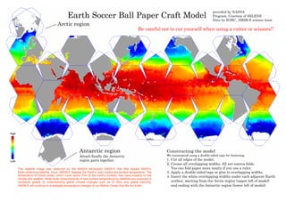
The document provides instructions for constructing an Earth paper craft model, beginning with cutting edges and creasing overlapping widths, then applying double-sided tape or glue to the overlaps and inserting them under adjacent surfaces starting from the Arctic region and ending with the Antarctic region. Safety is advised when using cutting tools. Satellite imagery from AMSR-E displays Earth's color-coded sea surface temperatures, which have significant impacts on climate and weather and are important for understanding changes like El Nino and global warming.

Recommended
More Related Content
What's hot
What's hot (12)
Similar to Construct Earth Soccer Ball Paper Craft Model
Similar to Construct Earth Soccer Ball Paper Craft Model (20)
More from ชีวิตนี้ จงอดทนในการเผชิญกับบททดสอบ
More from ชีวิตนี้ จงอดทนในการเผชิญกับบททดสอบ (20)
Recently uploaded
Recently uploaded (20)
Construct Earth Soccer Ball Paper Craft Model
- 1. Constructing the model We recommend using a double-sided tape for fastening. 1. Cut all edges of the model. 2. Crease all overlapping widths. All are convex folds. You can fold paper more neatly if you use a ruler. 3. Apply a double-sided tape or glue to overlapping widths. 4. Insert the white overlapping widths under each adjacent Earth surface, starting from the Arctic region (upper left of model) and ending with the Antarctic region (lower left of model). Earth Soccer Ball Paper Craft Model Arctic region This satellite image was observed by the NASDA -developed AMSR-E that flies aboard NASA’s Earth-observing satellite, Aqua. AMSR-E displays the Earth’s color-coded sea-surface temperature. The temperature of ocean areas, which cover about 70% of the Earth’s surface, has many impacts on the climate and weather. Wide-scale measurements of sea-surface temperature by satellites are expected to contribute greatly to understanding global climate changes such as El Nino and global warming. AMSR-E will continue to investigate temperature changes of our Mother Ocean that fills the Earth. provided by NASDA Program, Courtesy of SELENE Data by EORC, AMSR-E science team Antarctic region Attach finally the Antarctic region parts together. Be careful not to cut yourself when using a cutter or scissors!!