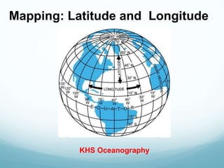
2. Latitude and Longitude
• Cartographers use an imaginary grid of parallel
lines and vertical lines to locate points on Earth.
• The equator circles Earth halfway between the
north and south poles separating Earth into two
equal halves called the northern hemisphere
and the southern hemisphere.
3. Latitude
Lines of latitude are lines running parallel to the equator.
• Latitude is the distance in degrees north or south of the
equator.
4. Latitude
Latitude is thus measured from 0° at the equator
to 90° at the poles.
• Locations north of the
equator are referred to
by degrees north
latitude (N).
• Locations south of the
equator are referred to
by degrees south
latitude (S).
5. Degrees of Latitude
Latitude
– Each degree of latitude is equivalent to about
111 km ( ) on Earth’s surface. 1° = 70 miles
– To locate positions on Earth more precisely,
cartographers break down degrees of latitude into
60 smaller units, called minutes (´). 1' = 1.2 miles
– A minute of latitude can be further divided into
seconds (´´). 1" = .02 miles
– Longitude is also divided into degrees, minutes,
and seconds.
6. Longitude
To locate positions in east and west directions,
cartographers use lines of longitude, also known as
meridians.
• Longitude is the distance
in
degrees east or west of
the
prime meridian.
• The prime meridian,
representing 0°
longitude, is the
reference point for
longitude.
7. Longitude
Points west of the prime meridian are numbered from 0°
to 180° west longitude (W).
• Points east of the prime meridian are numbered from 0°
to 180° east longitude (E).