Coastal Landforms Swanage
•Download as PPTX, PDF•
1 like•1,476 views

The document provides guidance for students on a research task about coastal landforms in Swanage, England. It includes 3 tasks: 1) Create an information resource on landforms in Swanage using annotated diagrams and descriptions, 2) Draw a labelled sketch map of the Swanage coast, and 3) Complete two practice questions. Resources such as photos and maps of the area are also provided to aid research.

Recommended
More Related Content
What's hot
What's hot (20)
Similar to Coastal Landforms Swanage
Similar to Coastal Landforms Swanage (20)
More from Mr Blackwell
More from Mr Blackwell (20)
Recently uploaded
Recently uploaded (20)
Coastal Landforms Swanage
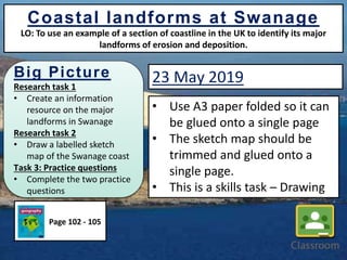
- 1. Big Picture Research task 1 • Create an information resource on the major landforms in Swanage Research task 2 • Draw a labelled sketch map of the Swanage coast Task 3: Practice questions • Complete the two practice questions Coastal landforms at Swanage LO: To use an example of a section of coastline in the UK to identify its major landforms of erosion and deposition. • Use A3 paper folded so it can be glued onto a single page • The sketch map should be trimmed and glued onto a single page. • This is a skills task – Drawing Page 102 - 105 23 May 2019
- 2. You can use an example of a section of coastline in the UK to describe its major landforms of erosion and deposition. You use a limited range of specialist terms You have a reasonable accuracy in the use of spelling, punctuation and grammar. You can use an example of a section of coastline in the UK to outline its major landforms of erosion and deposition. You use a good range of specialist terms You have a considerable accuracy in spelling, punctuation and grammar. You use an example of a section of coastline in the UK to explain its major landforms of erosion and deposition. You use a wide range of specialist terms where appropriate. Accurate use of spelling, punctuation and grammar. Learning Outcomes – Success Criteria L3 - Detailed Answer L2 - Clear Answer L1 - Basic Answer Coastal landforms at Swanage LO: To use an example of a section of coastline in the UK to identify its major landforms of erosion and deposition.
- 3. Coastal landforms at Swanage LO: To use an example of a section of coastline in the UK to identify its major landforms of erosion and deposition. Research task 1 Create an A3 information resource poster on the major landforms in Swanage You must include: 1. An annotated diagram to show how differential erosion can shape a discordant coastline. 2. An annotated sketch of the Foreland and Old Harry showing its characteristics and an explanation of its formation that included diagrams. 3. A description of the location of Swanage using the C.L.O.C.K. formula. 4. A plan sketch of Lulworth Cove with an explanation of its formation. Don’t forget to use your books, textbooks and ipad to help you
- 4. Coastal landforms at Swanage LO: To use an example of a section of coastline in the UK to identify its major landforms of erosion and deposition. C o a s t a l l a n d f o r m s a t S w a n a g e An annotated diagram to show how differential erosion can shape a discordant coastline. (Resource 2). An annotated sketch of the Foreland and Old Harry. (Resource 10). A description of Swanage’s location (C.L.O.C.K) A plan sketch of Lulworth Cove. (Resource 3) You may wish to lay it out in this fashion.
- 5. Coastal landforms at Swanage LO: To use an example of a section of coastline in the UK to identify its major landforms of erosion and deposition. C o a s t a l l a n d f o r m s a t S w a n a g e An annotated diagram to show how differential erosion can shape a discordant coastline. An annotated sketch of the Foreland and Old Harry A plan sketch of Lulworth Cove You may wish to lay it out in this fashion. Extension Ideas 1. Create before and after diagrams 2. Include an explanation of how discordant coastlines produce bays and headlands. Extension Ideas 1. Looking at the diagrams describe where the discordant coastline is and where the concordant coastline is. Extension Ideas 1. Annotate with where the processes of erosion may happen. 2. Annotate where types of weathering may occur. Extension Ideas 1. Explain who this feature formed on a concordant coastline. 2. Label with coastal features and processes. A description of Swanage’s location (C.L.O.C.K)
- 6. Resource 1: Concordant and discordant coast, Isle of Purbeck, Dorset Coastal landforms at Swanage LO: To use an example of a section of coastline in the UK to identify its major landforms of erosion and deposition. Produced by Mr M Colclough
- 7. Resource 2: Swanage coastline - Differential erosion of a discordant coastline Coastal landforms at Swanage LO: To use an example of a section of coastline in the UK to identify its major landforms of erosion and deposition.
- 8. Resource 3: Geology map of Lulworth Cove, Dorset, a concordant coastline. Coastal landforms at Swanage LO: To use an example of a section of coastline in the UK to identify its major landforms of erosion and deposition.
- 9. Coastal landforms at Swanage LO: To use an example of a section of coastline in the UK to identify its major landforms of erosion and deposition. Resource 4: Folding at Stair Hole; Lulworth Cove.
- 10. Coastal landforms at Swanage LO: To use an example of a section of coastline in the UK to identify its major landforms of erosion and deposition. Resource 5: The location of major landforms on the Dorset/Hampshire coast
- 11. Resource 7: Swanage Bay, Dorset Coastal landforms at Swanage LO: To use an example of a section of coastline in the UK to identify its major landforms of erosion and deposition.
- 12. Resource 8: Durlston Head near Swanage, Dorset Coastal landforms at Swanage LO: To use an example of a section of coastline in the UK to identify its major landforms of erosion and deposition.
- 13. Coastal landforms at Swanage LO: To use an example of a section of coastline in the UK to identify its major landforms of erosion and deposition. Resource 9: Location of Swanage.
- 14. Coastal landforms at Swanage LO: To use an example of a section of coastline in the UK to identify its major landforms of erosion and deposition. Resource 10: Foreland and Old Harry rocks
- 15. Research task 2 Coastal landforms at Swanage LO: To use an example of a section of coastline in the UK to identify its major landforms of erosion and deposition. Task: Draw a labelled sketch map of the Swanage coast. You must include: • Label all of the characteristics of the coastline (landforms) • Label and include the 6-figure grid reference of Old Harry • Label and include the 4-figure grid reference of Studland Heath
- 16. Resource 9: 1:50 000 OS map extract of Swanage coast Coastal landforms at Swanage LO: To use an example of a section of coastline in the UK to identify its major landforms of erosion and deposition.
- 17. Coastal landforms at Swanage LO: To use an example of a section of coastline in the UK to identify its major landforms of erosion and deposition. Task 3: Practice questions Question 1 Using evidence from the photos, evaluate any potential conflict between the different uses of the Dorset coast near Swanage and Studland. [6 marks] Photo: Swanage Bay, Dorset coast, England Photo: Studland Beach, Dorset coast, England
- 18. Coastal landforms at Swanage LO: To use an example of a section of coastline in the UK to identify its major landforms of erosion and deposition. Task 3: Practice questions Question 2 Use evidence from the OS map of the Swanage coast to suggest how the area’s human use has been affected by its physical geography. [4 marks] Bing Maps