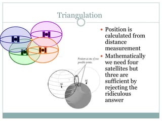
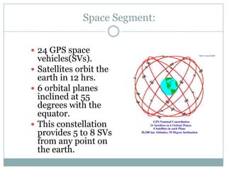
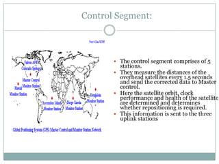
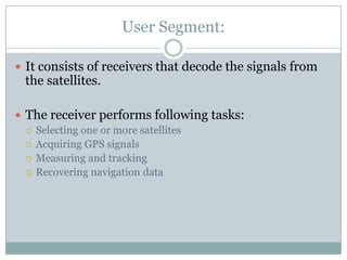
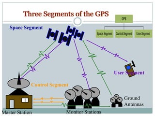
Global Positioning System
             A GADGET WHICH
        CHANGED THE WAY THE
             WORLD OPERATES

Seminar by:
B V Aparna
ECE
CMR College of Engg. And Tech
Why do we need GPS?

       Trying to figure out where you
        are is probable man’s oldest
        pastime.

       Finally US Dept of Defense
        decided to form a worldwide
        positioning system.

       Also known as NAVSTAR (
        Navigation Satellite Timing and
        Ranging Global positioning
        system) provides instantaneous
        position, velocity and time
        information.
Four Basic Functions of GPS

   Position and coordinates.

   The distance and direction between any two waypoints,
    or a position and a waypoint.

   Travel progress reports.

   Accurate time measurement.
How does the GPS work?

 Requirements
 Triangulation from satellite
 Distance measurement through travel time of radio
  signals
 Very accurate timing required
 To measure distance the location of the satellite
  should also be known
 Finally delays have to be corrected
GPS Satellite Signal:

 L1 freq. (1575.42 Mhz) carries the SPS code and the
  navigation message.
 L2 freq. (1227.60 Mhz) used to measure
  ionosphere delays by PPS receivers
 3 binary code shift L1 and/or L2 carrier phase
  The C/A code
  The P code
  The Navigation message which is a 50 Hz signal
   consisting of GPs satellite orbits . Clock correction and
   other system parameters
Signal generation in a GPS Satellite


L1
                          90
                                       Q
1575Mhz
                      I
              1.023
C/A code      Mbps                                              SUM
                                              C/A + NAV
               50 bps         Multipliers
Navigation
message                                                   L1+P+C/A
                                                          +NAV
              10.23                                       L1 output
P code        Mbps                          P+NAV

                                                           L2 output
L2                        I                                L2+P+NAV
1227 Mhz
Triangulation
             Position is
              calculated from
              distance
              measurement
             Mathematically
              we need four
              satellites but
              three are
              sufficient by
              rejecting the
              ridiculous
              answer
Measuring Distance

 Distance to a satellite is determined by measuring
  how long a radio signal takes to reach us from the
  satellite
 Assuming the satellite and receiver clocks are sync.
  The delay of the code in the receiver multiplied by
  the speed of light gives us the distance
Getting Perfect timing

                  If the clocks are perfect
                   sync the satellite range will
                   intersect at a single point.
                  But if imperfect the four
      T            satellite will not intersect
                   at the same point.
                  The receiver looks for a
T+3                common correction that
                   will make all the satellite
                   intersect at the same point
Space Segment:


 24 GPS space
  vehicles(SVs).
 Satellites orbit the
  earth in 12 hrs.
 6 orbital planes
  inclined at 55
  degrees with the
  equator.
 This constellation
  provides 5 to 8 SVs
  from any point on
  the earth.
Control Segment:


        The control segment comprises of 5
         stations.
        They measure the distances of the
         overhead satellites every 1.5 seconds
         and send the corrected data to Master
         control.
        Here the satellite orbit, clock
         performance and health of the satellite
         are determined and determines
         whether repositioning is required.
        This information is sent to the three
         uplink stations
User Segment:

 It consists of receivers that decode the signals from
 the satellites.

 The receiver performs following tasks:
   Selecting one or more satellites
   Acquiring GPS signals
   Measuring and tracking
   Recovering navigation data
User Segment:

There are two services SPS and PPS
The Standard Positioning Service
    SPS- is position accuracy based on GPS measurements on
     single L1 frequency C/A code


The Precise Position Service
    PPS is the highest level of dynamic positioning based on the
     dual freq P-code
    Only authorized users, this consists of SPS signal plus the P
     code on L1 and L2 and carrier phase measurement on L2
User Segment

 Military.
 Search and rescue.

 Disaster relief.

 Surveying.

 Marine, aeronautical and terrestrial navigation.

 Remote controlled vehicle and robot guidance.

 Satellite positioning and tracking.

 Shipping.

 Geographic Information Systems (GIS).

 Recreation.
Three Segments of the GPS
                                                             GPS

   Space Segment
                                         Space Segment Control Segment   User Segment


                                                      User Segment

             Control Segment

                                                               Ground
                                                               Antennas
Master Station             Monitor Stations
Errors in GPS

    The GPS is designed as accurate as possible.However, there are
    still errors and the most significant of these are discussed
    below:

   Atmospheric conditions
   Ephemeris errors
   Clock drift/measurement noise
   Selective availability
   multipath
Sources of GPS Error

Standard Positioning Service (SPS ): Civilian Users
     Source                   Amount of Error
    Satellite clocks:          1.5 to 3.6 meters
    Orbital errors:            < 1 meter
    Ionosphere:                5.0 to 7.0 meters
    Troposphere:               0.5 to 0.7 meters
    Receiver noise:            0.3 to 1.5 meters
    Multipath:                 0.6 to 1.2 meters
    User error:                Up to a kilometer or more
 Errors are cumulative and increased by PDOP.
Errors due to geometry

 Poor GDOP
   When angles from the
    receiver to the SVs
    used are similar


 Good GDOP
   When the angles are
    different
Sources of Signal Interference causing errors


 Earth’s Atmosphere


           Solid Structures


                         Metal   Electro-magnetic Fields
DGPS

        Errors in one position
         are similar to a local
         area
        High performance GPS
         receiver at a known
         location.
        Computes errors in the
         satellite info
DGPS

 Data Links
   Land Links
      MF,LF,UHF/VHF freq used
      Radiolocations,local FM, cellular telephones and marine radio
       beacons
    Satellite links
      DGPS corrections on the L band of geostaionary satellites
      Corrections are determined from a network of reference Base
       stations which are monitored by control centers like OmniSTAR
       and skyFix
Applications of GPS system

 Tracking is useful because it enables a central point
  to monitor the position of several vehicles or people,
  in real time, without them needing to relay that
  information explicitly. This can include children,
  criminals, police and emergency vehicles or military
  applications.
o GPS vehicle tracking is also used to locate stolen
  cars, or stolen mobiles.
 Once we know our location, we can, of course, find
  out where we are on a map, and GPS mapping and
  navigation is perhaps the most well-known of all the
  applications of GPS.
Applications of GPS system

 A tracking applications are not that much popular
  as the navigation applications. But, so many people
  take uses of them. It enables users to find a location
  of any object that is tagged with a system.
 Navigation applications are the most famous GPS
  applications. The latest releases of those applications
  allow users to have much advanced features and
  facilities.
 Other common applications:Car navigation,Hand
  held ,Tracking,GIS,Survey ,Manufacturing,Military
  Related 1%
Thank you

Global Positioning System ( GPS )

  • 1.
    Global Positioning System A GADGET WHICH CHANGED THE WAY THE WORLD OPERATES Seminar by: B V Aparna ECE CMR College of Engg. And Tech
  • 2.
    Why do weneed GPS?  Trying to figure out where you are is probable man’s oldest pastime.  Finally US Dept of Defense decided to form a worldwide positioning system.  Also known as NAVSTAR ( Navigation Satellite Timing and Ranging Global positioning system) provides instantaneous position, velocity and time information.
  • 3.
    Four Basic Functionsof GPS  Position and coordinates.  The distance and direction between any two waypoints, or a position and a waypoint.  Travel progress reports.  Accurate time measurement.
  • 4.
    How does theGPS work?  Requirements  Triangulation from satellite  Distance measurement through travel time of radio signals  Very accurate timing required  To measure distance the location of the satellite should also be known  Finally delays have to be corrected
  • 5.
    GPS Satellite Signal: L1 freq. (1575.42 Mhz) carries the SPS code and the navigation message.  L2 freq. (1227.60 Mhz) used to measure ionosphere delays by PPS receivers  3 binary code shift L1 and/or L2 carrier phase  The C/A code  The P code  The Navigation message which is a 50 Hz signal consisting of GPs satellite orbits . Clock correction and other system parameters
  • 6.
    Signal generation ina GPS Satellite L1 90 Q 1575Mhz I 1.023 C/A code Mbps SUM C/A + NAV 50 bps Multipliers Navigation message L1+P+C/A +NAV 10.23 L1 output P code Mbps P+NAV L2 output L2 I L2+P+NAV 1227 Mhz
  • 7.
    Triangulation  Position is calculated from distance measurement  Mathematically we need four satellites but three are sufficient by rejecting the ridiculous answer
  • 8.
    Measuring Distance  Distanceto a satellite is determined by measuring how long a radio signal takes to reach us from the satellite  Assuming the satellite and receiver clocks are sync. The delay of the code in the receiver multiplied by the speed of light gives us the distance
  • 9.
    Getting Perfect timing  If the clocks are perfect sync the satellite range will intersect at a single point.  But if imperfect the four T satellite will not intersect at the same point.  The receiver looks for a T+3 common correction that will make all the satellite intersect at the same point
  • 10.
    Space Segment:  24GPS space vehicles(SVs).  Satellites orbit the earth in 12 hrs.  6 orbital planes inclined at 55 degrees with the equator.  This constellation provides 5 to 8 SVs from any point on the earth.
  • 11.
    Control Segment:  The control segment comprises of 5 stations.  They measure the distances of the overhead satellites every 1.5 seconds and send the corrected data to Master control.  Here the satellite orbit, clock performance and health of the satellite are determined and determines whether repositioning is required.  This information is sent to the three uplink stations
  • 12.
    User Segment:  Itconsists of receivers that decode the signals from the satellites.  The receiver performs following tasks:  Selecting one or more satellites  Acquiring GPS signals  Measuring and tracking  Recovering navigation data
  • 13.
    User Segment: There aretwo services SPS and PPS The Standard Positioning Service  SPS- is position accuracy based on GPS measurements on single L1 frequency C/A code The Precise Position Service  PPS is the highest level of dynamic positioning based on the dual freq P-code  Only authorized users, this consists of SPS signal plus the P code on L1 and L2 and carrier phase measurement on L2
  • 14.
    User Segment  Military. Search and rescue.  Disaster relief.  Surveying.  Marine, aeronautical and terrestrial navigation.  Remote controlled vehicle and robot guidance.  Satellite positioning and tracking.  Shipping.  Geographic Information Systems (GIS).  Recreation.
  • 15.
    Three Segments ofthe GPS GPS Space Segment Space Segment Control Segment User Segment User Segment Control Segment Ground Antennas Master Station Monitor Stations
  • 16.
    Errors in GPS The GPS is designed as accurate as possible.However, there are still errors and the most significant of these are discussed below:  Atmospheric conditions  Ephemeris errors  Clock drift/measurement noise  Selective availability  multipath
  • 17.
    Sources of GPSError Standard Positioning Service (SPS ): Civilian Users Source Amount of Error  Satellite clocks: 1.5 to 3.6 meters  Orbital errors: < 1 meter  Ionosphere: 5.0 to 7.0 meters  Troposphere: 0.5 to 0.7 meters  Receiver noise: 0.3 to 1.5 meters  Multipath: 0.6 to 1.2 meters  User error: Up to a kilometer or more  Errors are cumulative and increased by PDOP.
  • 18.
    Errors due togeometry  Poor GDOP  When angles from the receiver to the SVs used are similar  Good GDOP  When the angles are different
  • 19.
    Sources of SignalInterference causing errors Earth’s Atmosphere Solid Structures Metal Electro-magnetic Fields
  • 20.
    DGPS  Errors in one position are similar to a local area  High performance GPS receiver at a known location.  Computes errors in the satellite info
  • 21.
    DGPS  Data Links  Land Links  MF,LF,UHF/VHF freq used  Radiolocations,local FM, cellular telephones and marine radio beacons  Satellite links  DGPS corrections on the L band of geostaionary satellites  Corrections are determined from a network of reference Base stations which are monitored by control centers like OmniSTAR and skyFix
  • 22.
    Applications of GPSsystem  Tracking is useful because it enables a central point to monitor the position of several vehicles or people, in real time, without them needing to relay that information explicitly. This can include children, criminals, police and emergency vehicles or military applications. o GPS vehicle tracking is also used to locate stolen cars, or stolen mobiles.  Once we know our location, we can, of course, find out where we are on a map, and GPS mapping and navigation is perhaps the most well-known of all the applications of GPS.
  • 23.
    Applications of GPSsystem  A tracking applications are not that much popular as the navigation applications. But, so many people take uses of them. It enables users to find a location of any object that is tagged with a system.  Navigation applications are the most famous GPS applications. The latest releases of those applications allow users to have much advanced features and facilities.  Other common applications:Car navigation,Hand held ,Tracking,GIS,Survey ,Manufacturing,Military Related 1%
  • 24.