Potential of analytical element modeling

Analytical element modelling (AEM) as a tool to quantify the impact of weirs on groundwater levels Jayson Gabriel Pinza University of Antwerp Sarah Garré Instituut voor Landbouw-, Visserij- en Voedingsonderzoek Jan Vanderborght KULeuven Forschungszentrum Jülich GmbH Jan Staes University of Antwerp Climate change can influence the hydrology of rural areas, affecting the availability of surface and groundwater along with potential flood and drought risks that impact people and even ecosystems. In these areas, a suitable design of ditch network accompanied by proper weir operation schemes is imperative to improve groundwater recharge that will alleviate water scarcity and also to minimize unwanted water surpluses on surface. Here, we show that analytic element modeling (AEM) can be performed as a less computationally intensive visual guide to determine (1) the best monitoring sites for ditch water and groundwater levels and (2) the predicted impacts of weir operations on these water levels during a hydrological year, given the proposed locations and scheduled periods of opening and closing of these weirs. With these, water resource managers in rural areas can use AEM as a preliminary tool to refine both the monitoring of ditches and the operation of weirs at landscape-scale level to minimize impending threats from future floods and droughts.

Recommended
More Related Content
Similar to Potential of analytical element modeling
Similar to Potential of analytical element modeling (20)
More from SBO TURQUOISE
More from SBO TURQUOISE (13)
Recently uploaded
Recently uploaded (20)
Potential of analytical element modeling
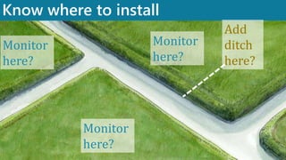
- 1. Know where to install Slide 1 Monitor here? Add ditch here? Monitor here? Monitor here?
- 2. Know where to install Weir? Weir? Weir?
- 3. Schedule the operation of weirs properly When to open? Close? How often? Slide 3
- 4. We need guiding tools! Slide 4
- 5. Preliminary Tools for Better Hydrological Management of Ditches and Weirs Slide 5 Presenter Jayson Gabriel Pinza Joint PhD Student Other Contributors Jan Vanderborght Sarah Garré Jan Staes Analytic Element Models
- 6. What are analytic element models (AEM)? Slide 6
- 7. Conceptualizing the problem Slide 7 North Ditch South Ditch 0 meters 10 meters Unconfined aquifer What will be the groundwater levels? Recharge N West Ditch Central Ditch East Ditch ? ? ? ?
- 8. How does AEM work? Using discharge potentials 𝛷 Slide 8 𝛷𝑛𝑜𝑟𝑡ℎ 𝑑𝑖𝑡𝑐ℎ 𝛷𝑠𝑜𝑢𝑡ℎ 𝑑𝑖𝑡𝑐ℎ 𝛷 𝑥, 𝑦 = 𝛷𝑟𝑒𝑐ℎ𝑎𝑟𝑔𝑒 + 𝛷𝑛𝑜𝑟𝑡ℎ 𝑑𝑖𝑡𝑐ℎ+ 𝛷𝑠𝑜𝑢𝑡ℎ 𝑑𝑖𝑡𝑐ℎ + 𝛷𝑤𝑒𝑠𝑡 𝑑𝑖𝑡𝑐ℎ + 𝛷𝑐𝑒𝑛𝑡𝑟𝑎𝑙 𝑑𝑖𝑡𝑐ℎ + 𝛷𝑒𝑎𝑠𝑡 𝑑𝑖𝑡𝑐ℎ + 𝛷𝑤𝑒𝑠𝑡 𝑏𝑜𝑢𝑛𝑑𝑎𝑟𝑦+ 𝛷𝑒𝑎𝑠𝑡 𝑏𝑜𝑢𝑛𝑑𝑎𝑟𝑦 𝛷𝑤𝑒𝑠𝑡 𝑏𝑜𝑢𝑛𝑑𝑎𝑟𝑦 𝛷𝑒𝑎𝑠𝑡 𝑏𝑜𝑢𝑛𝑑𝑎𝑟𝑦 𝛷𝑟𝑒𝑐ℎ𝑎𝑟𝑔𝑒 𝛷𝑤𝑒𝑠𝑡 𝑑𝑖𝑡𝑐ℎ 𝛷𝑐𝑒𝑛𝑡𝑟𝑎𝑙 𝑑𝑖𝑡𝑐ℎ 𝛷𝑒𝑎𝑠𝑡 𝑑𝑖𝑡𝑐ℎ SUPERPOSITION
- 9. From discharge potentials 𝛷, get discharges Q and heads h Slide 9 𝛷 𝑥, 𝑦 ℎ = 2𝛷 𝑘 𝑄𝑥 = − 𝑑𝛷 𝑑𝑥 𝑄𝑦 = − 𝑑𝛷 𝑑𝑦
- 10. Research Question “How can AEM be applied in ditch- weir management?” Slide 10
- 12. AEM does not need meshes Slide 12 Modified from Polyzos (2019) AEM MODFLOW HYDRUS
- 13. More effort for MODFLOW/HYDRUS Slide 13 10 000 m2 2 000 m2
- 14. AEM is flexible on any scales Slide 14 10 000 m2 2 000 m2
- 15. Our objective: Predict groundwater levels Slide 15 Ditch water levels Groundwater Levels
- 16. Ditches as line sinks Slide 16 You can specify water levels or heads h h = 0 meters
- 17. Case 1: Simple Ditch Network Slide 17
- 18. Conceptualizing Case 1 Slide 18 North Ditch South Ditch 0 meters 10 meters Unconfined aquifer Recharge 400 mm/year N West Ditch Central Ditch East Ditch Hydraulic conductivity 1 meter/day 400 meters 1600 meters Ditch heads are constantly 0
- 19. Building AEM for Case 1 Slide 19 400 m 1600 m “Open” Boundary “Open” boundary West Ditch North Ditch South Ditch Central Ditch East Ditch N
- 20. Results show “dome” patterns Slide 20 1.22 m Central Ditch East Ditch North Ditch South Ditch 1.22 m 1.22 m 1.22 m West Ditch N
- 21. Peaks are 1.2 m above ditch water level Slide 21
- 22. Application: Know where to install Slide 22 Monitor here? Add ditch here? Monitor here? Monitor here?
- 23. Our objective: Predict groundwater levels Slide 23 Ditch water levels Groundwater Levels Weir operation schemes
- 24. Case 2: Add weirs and retain water Slide 24
- 25. How is closure of weirs represented? Slide 25 Retain water Weir Water level = 0 Water level > 0 m Ditch water levels (to be retained) can be specified Water level = 0 Weir
- 26. Conceptualizing Case 2 Slide 26 North Ditch South Ditch 0 meters 10 meters Unconfined aquifer Recharge 400 mm/year N West Ditch Central Ditch East Ditch Hydraulic conductivity 1 meter/day 400 meters 1600 meters Weir Weir Weir Weir Weir Weir Constant head 0.5 m Constant head 0.5 m Constant head 0.5 m
- 27. Building AEM for Case 2 Slide 27 400 m 1600 m “Open” Boundary “Open” boundary West Ditch North Ditch South Ditch N Central Ditch East Ditch 100 m Weir Weir Weir Weir Weir Weir Constant head 0.5 m Constant head 0.5 m Constant head 0.5 m
- 28. Slide 28 1.31 m Asymmetrical Asymmetrical Elliptical Elliptical N Weir Weir Weir Weir Weir Weir 1.38 m 1.38 m 1.31 m 1.22 m 1.22 m 1.22 m 1.22 m No weirs (Case 1) With weirs (Case 2) Result: domes are now irregular
- 29. Result: closing weirs increase water levels Slide 29
- 30. Application? Know where to install Slide 30 Monitor here? Add ditch here? Monitor here? Monitor here? Install weirs here? Install weir here?
- 31. Case 3: Open these weirs and drain water away Slide 31
- 32. From Initial State (from Case 2) Slide 32 Central Ditch East Ditch North Ditch South Ditch West Ditch 1.2 m 1.3 m 1.3 m 1.2 m N Weir Weir Weir Weir Weir Weir 1.31 m Weir Weir Weir Weir Weir Weir 1.38 m 1.38 m 1.31 m
- 33. Open the weirs until 0 m everywhere Slide 33 Central Ditch East Ditch North Ditch South Ditch West Ditch N Weir Weir Weir Weir Weir Weir
- 34. Mini-research Question How much time is the decrease down to 0 meters? Slide 34
- 35. Thus, perform AEM in Transient State Slide 35 North Ditch South Ditch 0 meters 10 meters Unconfined aquifer Recharge 400 mm/year N West Ditch Central Ditch East Ditch Hydraulic conductivity 1 meter/day 400 meters 1600 meters Weir Weir Weir Weir Weir Weir Weirs still closed (initial state) Constant head 0.5 m Constant head 0.5 m Constant head 0.5 m
- 36. Thus, perform AEM in Transient State Slide 36 North Ditch South Ditch 0 meters 10 meters Unconfined aquifer Recharge 400 mm/year N West Ditch Central Ditch East Ditch Hydraulic conductivity 1 meter/day 400 meters 1600 meters Weir Weir Weir Weir Weir Weir Storativity 26% (average for medium-grained sand) Weirs have been opened (day 1 onwards) Constant head 0 m Constant head 0 m Constant head 0 m 0 mm/year
- 37. How long for the levels to fall down to 0 meters? Answer: 4 to 5 years Slide 37 Central Ditch East Ditch North Ditch South Ditch West Ditch 1.2 m 1.3 m 1.3 m 1.2 m N Weir Weir Weir Weir Weir Weir 1.31 m 1.38 m 1.38 m 1.31 m 0.55 m 0.55 m 0.55 m 0.55 m 0.20 m 0.20 m 0.20 m 0.20 m 0.07 m 0.07 m 0.07 m 0.07 m Day 0 Day 400 Day 800 Day 1200 Weir Weir Weir Weir Weir Weir 0.02 m 0.02 m 0.02 m 0.02 m Day 1600
- 38. How long for the levels to fall down to 0 meters? Slide 38 Answer: 4 to 5 years
- 39. Application? Know the ideal schedule of weir operation Slide 39 When to open? Close? How often? Slide 39
- 41. How to apply AEM in ditch-weir management? Slide 41 Ditches: use line sinks Opening/closing of weirs: use different constant head values for segments h = 0 meters Retain water Weir Water level = 0 Water level > 0 m Water level = 0 Weir
- 42. How to apply AEM in ditch-weir management? Slide 42 OUTPUT: 1. Predicted groundwater levels 2. Evolution of groundwater levels through time
- 43. Outlook Slide 43
- 44. Apply on real world cases Slide 44 Managing Agriculture
- 45. Apply on real world cases Slide 45 Agricultural management Maintaining Ecological Flow
- 46. Couple with existing hydro(geo)logical models Slide 46 AEM x large scale models? Weir Weir Weir Weir Weir Weir Weir Weir WeirWeir Weir Weir Weir
- 47. Preliminary Tools for Better Hydrological Management of Ditches and Weirs Slide 47 Presenter Jayson Gabriel Pinza Joint PhD Student Other Contributors Jan Vanderborght Sarah Garré Jan Staes Analytic Element Models
Editor's Notes
- http://adlib.everysite.co.uk/adlib/defra/content.aspx?id=2RRVTHNXTS.8M4WXN3NSO0R1
- http://adlib.everysite.co.uk/adlib/defra/content.aspx?id=2RRVTHNXTS.8M4WXN3NSO0R1
- Uniform recharge also
- Quite flexible at any scale Large area – many ditches -irregularly spaced Domain periodic? Not Density of ditches, orientation, vary with landscape! MODFLOW – setup such model for any smaller area Need to build so many models A lot of fine grid cells AEM – they allow you to address problems related to scale Advantage! Thing we are aiming for: AEM merge with large scale groundwater flow models Coupling! So that we know the impact of weirs on larger scale water flows and storage on watershed scale IDEA: How can we couple AEM with larger scale numerical models
- http://adlib.everysite.co.uk/adlib/defra/content.aspx?id=2RRVTHNXTS.8M4WXN3NSO0R1
- http://adlib.everysite.co.uk/adlib/defra/content.aspx?id=2RRVTHNXTS.8M4WXN3NSO0R1
- http://adlib.everysite.co.uk/adlib/defra/content.aspx?id=2RRVTHNXTS.8M4WXN3NSO0R1
- One part: model coupling Another part: model application for agriculture and other purpose
- https://www.dreamstime.com/small-weir-ditch-two-fields-backlight-image-small-weir-ditch-two-fields-netherlands-image167990218
- https://www.seakayakbelgium.eu/kleine-nete.html
- 2. Craig and Rabideau (2006a, b) developed a new method for coupling AEM flow models with FEM and FDM transport models. They obtained good results, but the transport model was still mesh-dependent. https://www.cesdb.com/gsflow.html
- One part: model coupling Another part: model application for agriculture and other purpose