Presentatie door Albrecht Weerts, Deltares, TU Delft
, op de Delft-FEWS NL Gebruikersdag 2018, tijdens de Deltares Software Dagen - Editie 2018. Dinsdag, 5 juni 2018, Delft.
DSD-NL 2018 Inundatie in het landelijk gebied door extreme neerslag of dijkdo...Deltares
Presentatie door Govert Verhoeven, Deltares, op het D-HYDRO Symposium 2018, tijdens de Deltares Software Dagen - Editie 2018. Woensdag, 6 juni 2018, Delft.
Groundwater dynamics play a crucial role in landscape rehydratation. However, there is still a big gap in the understanding of the groundwater flow dynamics. Heterogeneities and dynamics are often underestimated and therefore not taken into account. They are of crucial input for successful management and design of measures like weirs and level-controled drainage systems. The bulk of the mass of mass often is transported through only a small layer or section within the aquifer and is in cases of seepage into surface water very dependent to rainfall, evapotranspiration and occurring tidal effects. This study contains the use of novel real-time iFLUX sensors to map the groundwater flow dynamics over time.
The iFLUX sensor provides real-time data on groundwater flow rate and flow direction. It consists of multiple bidirectional flow sensors that are superimposed. The sensor probe can be installed directly in the subsoil, riverbed or monitoring well. The measurement setup is unique as it can perform measurements every second, ideal to map rapid changing flow conditions. The measurement range is between 0,5 and 500 cm per day.
The City Walls of Damme are a nature reserve of 140 hectares, located near walls of Dam-me. Specific measures were taken to achieve the rewetting of grasslands and swamp forests. A unique real-time hydrological measurement network supports the measures. The network consists of several iFLUX flow sensors to map infiltration, drainage & horizontal flow, combined with a network of groundwater and surface water level, salinity and meteo data. The project also includes a dune ridge infiltration to create an inland freshwater reserve in the coast and raise the freshwater table in order to counter the salinization of the coastal zone. The iFLUX sensing network is being expanded in that zone. Flux sensors in combination with EC sensors will continuously monitor the infiltrated freshwater bubble and its surroundings.
An important shortcoming of modelling tools that are used for managing hydro(geo)logical problems is that the tools are focusing on one specific compartment of the terrestrial system such as the groundwater, the soil water, or the surface water. However, the management of complex water related problems requires a holistic approach that considers the interactions between the different compartments at local and regional scales. For instance, the soil water status at a farmer’s field is influenced by the groundwater level whereas groundwater levels depend on the interaction with the surface water and on groundwater recharge and water infiltration and percolation through the soil in a larger area. Local measures that influence the water infiltration and surface water levels have an impact on the local soil water balance and groundwater recharge and influence groundwater levels and storage at a larger scale. These interactions between different compartments and acting at different spatial and temporal scales can be represented in fully coupled hydrological models of the terrestrial system that consider groundwater, soil, vegetation, and atmosphere. Using physics-based models, that solve mass and energy balance equations based on gradient-based estimates of fluxes, the different compartments can be coupled straightforwardly and consistently and information about the geology, soil types, vegetation, and topography of the region can be included in the model, in principle without calibration. One of the big advantages of physics-based models is that local changes can be related directly to parameter changes of the model so that their impact on the terrestrial water balance can be evaluated directly without requiring data about the reaction of the system to such changes that are needed to re-parameterize the model.
A coupled model integrating groundwater, surface water (ParFlow), and landsurface-atmosphere interactions (CLM) has been setup for central Europe including Germany, the Benelux (covering the entire Scheldt and Meuse catchments), Switzerland, Austria, and the Czech Republic. The model is parameterized using harmonized geological (International Hydrogeological Map of Europe) and soil data (SoilGrids texture), using generic land use classes, and topography at a spatial resolution of 611 by 611 m. This model is implemented on the GPU booster of the Jülich Supercomputer Centre and driven by atmospheric forecasts obtained from the ECMWF. It provides 10-day forecasts of the hydrological status of the terrestrial system (wassermonitor) and a time series of 10 years providing a climatology of hydrological variables such as water storage and groundwater level.
We give a short demonstration of the model and present simulat
De Vlaamse landbouw heeft, vooral in relatief vlakke gebieden, een uitgebreid netwerk aan grachten en beken om de percelen te draineren in natte periodes. Deze drainage verdroogt het landschap en zorgt voor bijkomende opbrengstverliezen bij droogte. Gezien de acute droogteproblematiek is het belangrijk dat het landbouwkundig waterbeheer verduurzaamt waarbij de impact van landbouw op het watersysteem wordt ingeperkt. Door regelbare landbouwstuwen te installeren in grachten kunnen landbouwers zelf de lokale waterhuishouding beheren. Landbouwstuwen houden het water in het fijnmazige grachtenstelsel langer op, wat zorgt voor een langere infiltratietijd. Hierdoor verhoogt het bodemvochtgehalte en ook de grondwaterstanden in de omliggende percelen. Op lange termijn wordt er aan drukopbouw gedaan en worden grondwaterreserves minder snel uitgeput.
Vanuit de Bodemkundige Dienst van België wordt er onderzoek gedaan naar de geschiktheid van landbouwstuwen en naar hun impact op het omliggende landschap en de gewasopbrengst. Een gedetailleerde terrein- en bodemstudie, op basis van het Digitaal Hoogtemodel en de Belgische Bodemkaart, bepaalt de geschiktheid van landbouwstuwen op perceelsniveau. Aanvullend worden, met behulp van tijdsreeksanalyse, grondwaterstanden gesimuleerd voor een ongestuwd en gestuwd scenario. Vanuit een bodemwaterbalans-model worden vervolgens voor een ongestuwd en gestuwd scenario gewasopbrengsten berekend. Dit laat toe om advies te geven op basis van kwalitatieve en kwantitatieve criteria om zo landbouwstuwen optimaal in te zetten om de effecten van droogte te bestrijden.
Voor landbouwstuwen in het domein van De Liereman te Oud-Turnhout werd, voor het desbetreffende VLM project, een meerwaarde tot 7% in de gewasopbrengst geschat. Voor Bocholt Stuwt, een project gefinancierd door het Droogte Innovatie Fonds van provincie Limburg, worden aan de hand van de bovenvermelde analyse er 20 landbouwstuwen geïnstalleerd op strategische locaties. Deze worden gemonitord aan de hand van grondwatermetingen in de omgeving van de stuw en metingen van waterstanden in grachten. Aan de Prinsenloop in Noord-Limburg werd via een RTK-GPS het grachtenstelsel nauwkeurig in kaart gebracht. Een uitvoerige analyse op basis van deze resultaten identificeerde potentieel droge en natte gebieden.
Er zullen nieuwe stuwen worden geplaatst om het bestaande netwerk van stuwen dat dateert van begin jaren 2000 te optimaliseren aan de huidige omstandigheden. Bovenvermelde onderzoeken streven naar lokaal waterbeheer doormiddel van stuwen te plaatsen op de meest geschikte locatie, om de meeste impact te hebben. Deze landbouwstuwen hebben een groot potentieel om water op te houden in het fijnmazig grachtenstelsel en droogte-effecten te mitigeren.
The past dry summers of 2018, 2019 and 2020 have indicated the sensitivity of Flemish agriculture to drought. In the Flemish polders, this resulted not only in crop water stress, but also in increasing soil and water salinity levels due to the high evaporative demand which rises the historical saline water up to the root zone. Due to the increasing occurrence of weather extremes as a consequence of climate change, farmers and farming systems will need to adapt with both too little and too much freshwater in the future. Compared to conventional drainage systems, controlled drainage can secure crop productivity and lower the irrigation need by draining water only when it is strictly necessary and thereby leaving more opportunities for water retention and groundwater recharge.
As part of the project OP-PEIL, we will investigate the impact of adaptive drainage on water fluxes and availability, water quality as well as on the cropping system itself (crop growth, disease pressure, yield and quality) during 3 years. We will use geophysical techniques to monitor the impact of controlled drainage on the fresh/salt water interface in the drained field, as well as in the nearby landscape. Finally, we will set up numerical experiments using SWAP (water balance model), available historical climate, field management, and soil hydraulic properties data. This numerical experiment aims to evaluate more extensive climatological scenarios. By the end, this project will raise awareness of farmers and stakeholders about the impact of controlled drainage on agricultural practices in the Flemish Polders in Belgium.
Climate Adaptive Drainage CAD
Developments, experiences from 2010 to present, and application in Flanders
‘Smart Drainage Systems and Smart Management’
Scientific Knowledge Exchange
Brussels (B) November 10,2022
Potential of analytical element modelingSBO TURQUOISE
Analytical element modelling (AEM) as a tool to quantify the impact of weirs on groundwater levels
Jayson Gabriel Pinza
University of Antwerp
Sarah Garré
Instituut voor Landbouw-, Visserij- en Voedingsonderzoek
Jan Vanderborght
KULeuven
Forschungszentrum Jülich GmbH
Jan Staes
University of Antwerp
Climate change can influence the hydrology of rural areas, affecting the availability of surface and groundwater along with potential flood and drought risks that impact people and even ecosystems. In these areas, a suitable design of ditch network accompanied by proper weir operation schemes is imperative to improve groundwater recharge that will alleviate water scarcity and also to minimize unwanted water surpluses on surface. Here, we show that analytic element modeling (AEM) can be performed as a less computationally intensive visual guide to determine (1) the best monitoring sites for ditch water and groundwater levels and (2) the predicted impacts of weir operations on these water levels during a hydrological year, given the proposed locations and scheduled periods of opening and closing of these weirs. With these, water resource managers in rural areas can use AEM as a preliminary tool to refine both the monitoring of ditches and the operation of weirs at landscape-scale level to minimize impending threats from future floods and droughts.
Controlled drainage with subirrigation
A management measure to discharge, retain, and recharge fresh groundwater
Janine de Wit (KWR & WUR)
Marjolein van Huijgevoort (KWR), Gé van den Eertwegh (KnowH2O), Dion van Deijl (KnowH2O), Jos van Dam (WUR), Ruud Bartholomeus (KWR & WUR)
10th November 2022, Brussel, Belgium
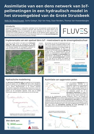
1. Niels De Vleeschouwer, Sacha Gobeyn, Stijn Van Hoey, Daan Renders, Thomas Van Hoestenberghe
Assimilatie van een dens netwerk van IoT-
peilmetingen in een hydraulisch model in
het stroomgebied van de Grote Struisbeek
Monitoring datavolledigheid
Monitoring ba�erijcapaciteit
Introduc�e
Implementatie van een spatiaal dens IoT - meetnetwerk op de stroomgebiedsschaal
Hydraulische modellering
Met dank aan:
Assimilatie van opgemeten peilen
Hydraulische modelpredic�es in onbevaarbare waterlopen kunnen betrouwbaarder worden gemaakt door
betere ruimtelijke en temporele inputdata te gebruiken. Maar daarnaast kan ook ingezet worden op een
intensievere beme�ng binnen het stroomgebied. Een plotse verstopping van een duiker zal bv. enkel in
rekening kunnen worden gebracht als in de buurt de effecten op het waterpeil worden opgemeten. Deze
me�ngen kunnen bovendien gevoed worden in het hydraulische model a.d.h.v. een data-assimila�ealgoritme
om de betrouwbaarheid van de real-�me predic�es te verhogen.
In de zomer van 2021 werden in het kader van het VLAIO-project
"Digital twin: River" binnen het stroomgebied van de Grote
Struisbeek, een 20-tal low-cost Internet of Things (IoT) peilsensoren
in de waterlopen geplaatst. Dit stroomgebied is gesitueerd ten
zuiden van Antwerpen en kent de nodige waterproblema�ek.
Bij het beheer van een dens IoT-meetnetwerk komt veel
kijken om de me�ngen zo kwalita�ef mogelijk te maken
en te houden. Binnen het VLAIO-project wordt dan ook
ingezet op de ontwikkeling van een gedegen sensor- en
meetplaatsmanagementsysteem. Dit houdt o.a. het
gebruik van een eenvoudig te gebruiken loggingsysteem
in waarin sensor- en meetplaatsinforma�e maar ook
installa�e- en onderhoudsevents worden bijgehouden.
Verder wordt de meetplaats- en sensorsta�s�eken zoals
ba�erijcapaciteit, data-volledigheid, etc. gemonitored.
Verder worden post-processingtechnieken ontwikkeld
om de ruwe data op te schonen. (bv. detec�e van
onnatuurlijke sprongen, flat-line signaal van een sensor,
etc.)
Een open-source 1D hydraulisch model werd opgesteld van het stroomgebied.
Hierbij werd gekozen voor het SWMM-model (Storm Water Management
Model). Er werd hiervoor gebruik gemaakt van open data en opme�ngsdata
van de Vlaamse Milieumaatschappij en de Provincie Antwerpen
(dwarsprofielen, lengteprofiel, waterbouwkundige infrastructuur). Binnen een
onderzoek van de Ugent werd de modellering en kalibra�e van het opwaartse
gedeelte van het stroomgebied uitgewerkt. Verder werd de SWMM
implementa�e vergeleken met een implementa�e van het HEC-RAS model.
A.d.h.v. een aangepast nudgingalgoritme wordt
de complementaire informa�e in de
peilme�ngen aangewend om de gemodelleerde
debieten en peilen in het SWMM-model te
corrigeren rich�ng werkelijke toestand op het
terrein. Assimila�e van me�ngen ter hoogte van
een meetloca�e vertaalt zich in een
gecorrigeerde modeltoestand ter hoogte van
deze meetloca�e, maar ook stroomopwaarts en
afwaarts van deze loca�e worden door het
algoritme en de modeldynamiek correc�es doorgevoerd. Hierbij is het belangrijk dat
systema�sche afwijkingen tussen modelresultaten en observa�es ter hoogte van de meetloca�e
zo goed als mogelijk op voorhand worden geïden�ficeerd en gecorrigeerd. De veelheid aan
meetplaatsen laat toe een aantal interessante onderzoeksvragen te beantwoorden. Zo kan o.a.
geëvalueerd worden waar best het peil wordt gemonitored binnen het stroomgebied, en welke
spa�ale en temporele meetdensiteit vereist is voor welk vooropgesteld doel. De antwoorden op
deze vragen dienen een kostenefficiënte opschaling van in-situ peilme�ngen op de
stroomgebiedsschaal te faciliteren �jdens toekoms�ge meetcampagnes.
Smartends
IoT-peilsensor
data-assimila�e principe
Loggingsysteem
Vergelijking van observa�es (rood) en simula�es (blauw) ter hoogte van
enkele meetplaatsen in het opwaartse gedeelte van het stroomgebied
Data-assimila�e van meetdata beschikbaar op
meetplaats C3, evalua�e op overige meetplaatsen