TGS Arcis- East Coast- Nova Scotia Renaissance phase
•
1 like•213 views

This document describes a multi-client 2D seismic survey conducted off the coast of Nova Scotia, Canada. It details the acquisition parameters, processing workflows, and available deliverables for both time and depth processing of the 2518.3 km survey. Time processing included velocity analysis, multiple attenuation, migration, stacking, and filtering to produce processed time migrations. Depth processing utilized iterative velocity model building, Kirchhoff pre-stack depth migration, and reverse time migration to produce processed depth volume images of the subsurface geology including sediment, salt, and subsalt structures.

Recommended
Recommended
More Related Content
What's hot
What's hot (20)
Similar to TGS Arcis- East Coast- Nova Scotia Renaissance phase
Similar to TGS Arcis- East Coast- Nova Scotia Renaissance phase (20)
More from TGS
More from TGS (20)
Recently uploaded
Recently uploaded (20)
TGS Arcis- East Coast- Nova Scotia Renaissance phase
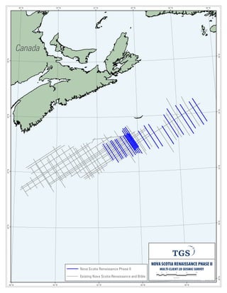
- 1. Canada 56°W SPM 58°W 58°W 60°W 60°W 62°W 62°W 64°W 64°W 66°W 66°W 46°N 46°N 44°N 44°N 42°N 42°N 40°N 38°N 40°N NOVA SCOTIA RENAISSANCE PHASE II MULTI-CLIENT 2D SEISMIC SURVEY 0 20 40 80 120 160 Kilometers N: Pub licGISArc Map Do cume ntsCa nad aSpe cSh eetMa psNovaScotiaRe naissan ce PHI I 20 13_Spe c ( port).mxd No vemb er 14, 201 3 Nova Scotia Renaissance Phase II Existing Nova Scotia Renaissance and Bible
- 2. NOVA SCOTIA RENAISSANCE PHASE II Pre-stack Time and Depth Migration Multi-client 2D Survey; 2518.3 km ACQUISITION PARAMETERS Survey/Acquisition Date: NS-100 July -Oct 1998 NS-100 May - Oct 1999 Data Acquired By: Geco-Prakla Geco-Prakla Recording Instrument: Nessie 3 Nessie 3 Airgun Source: 7918 cubic inches 7918 cubic inches Gun Depth: 7.5 meters +/-1 meter 7.5 meters +/-1 meter Shotpoint Interval: 37.5 meters 37.5 meters Group Interval: 25 meters 25 meters Recording Channels: 240 320 Streamer Depth: 9 meters +/-1.5 meters 9 meters +/-1.5 meters Streamer Length: 6000 meters 8000 meters Record Length: 14.336 seconds 14.336 seconds Sample Interval: 2 milliseconds 2 milliseconds Nominal Fold: 80 106 TIME PROCESSING SEQUENCE Data processing performed by: Arcis Seismic Solutions, Calgary Completed: 30 July, 2013 Input navigation merged seismic @ 4msec Swell noise attenuation and noise editing Debubble and zero phasing Coherent noise suppression Tau-P Deconvolution (as necessary in shallow water) Surface related multiple elimination (SRME) Velocity analysis, one per two kilometers High resolution radon demultiple Shifted apex radon or HMT diffracted demultiple – output Pre-migration Demultiple Migration velocity analysis, one per kilometer – output Migration Velocities Prima Kirchhoff pre-stack time migration – output PSTM Gathers without NMO Automatic velocity picking (2nd & high order) – output Stacking Velocities Final NMO Radon – output PSTM Gathers with NMO and Radon Gun and cable static correction Stack – output Raw Migration Filter and scale – output Processed Migration AVAILABLE TIME DELIVERABLES Raw field data / shot ordered (SEGD) Field data with navigation in the trace headers/shot ordered (240/320 trace/shot) (From NS-100R survey) Radon de-multiple CDP gathers (80/106 fold) Pre-stack time migrated CDP gathers without NMO (12.5m, 80/106 fold) Pre-stack time migrated CDP gathers with NMO (12.5m, 80/106 fold) Raw migration Processed migration Migration velocities - RMS (SEGY & ASCII) Stacking velocities (SEGY & ASCII) Processed source-receiver navigation (UKOOA) Post stack navigation (UKOOA) 30 January, 2014
- 3. NOVA SCOTIA RENAISSANCE PHASE II Pre-stack Time and Depth Migration Multi-client 2D Survey; 2518.3 km DEPTH PROCESSING SEQUENCE Estimated Completion: 13 December, 2013 Build Initial Velocity Model Build initial model from smoothed PSTM velocity field Create Data for Model Building Purposes Input Radon gathers, sum to 40 or 53 fold for Kirchhoff iterations, 14 sec, 4ms KIRCHHOFF PSDM: ITERATIONS I & II - Tomography Updates Kir: Output 25m CMP, 16km depth, 10m step, 40/53fold; Aperture 8000m Tomography (2-passes) to define sediment velocity model KIRCHHOFF PSDM: ITERATION III - Tomography Update Kir: Output 25m CMP, 40/53fold; 16km depth, 10m step, Aperture 8000m KIRCHHOFF PSDM: ITERATION IV - Define Top of Salt Kir: Output 25m CMP, 40/53fold; 16km depth, 10m step, Aperture 9200m RTM & KIRCHHOFF PSDM: ITERATION V - Define Base of Salt Kir: Output 25m CMP, 40/53fold; 16km depth, 10m step, Aperture 9200m RTM: Input all shots @ 8ms, Output 25m CMP, 16km, 10m step, 25Hz; Aperture 9200m RTM & KIRCHHOFF PSDM: ITERATION VI – Analyze Salt Overhangs and Iterate (as needed) KIRCHHOFF PSDM: ITERATION VII – Subsalt Tomography Update Kir: Output 25m CMP, 40/53fold; 16km depth, 10m step, Aperture 8000m Tomography to define final velocity field Final Isotropic Reverse Time and Kirchhoff Migrations Kir: Output 25m CMP, 40/53fold; 16km depth, 5m step, Aperture 9200m Output: Kirchhoff PSDM gathers with residual NMO RTM: Input all shots @8ms, Output 12.5m CMP, 16km, 10m step, 30Hz; Aperture 9200m Output: RTM pre-stack depth migrated - raw Stack Kirchhoff Output: Kirchhoff pre-stack depth migrated - raw Post Stack Processing (Filtering, spectral shaping, FK Power, Scaling) Output: RTM pre-stack depth migrated - processed Output: Kirchhoff pre-stack depth migrated - processed AVAILABLE DEPTH DELIVERABLES Reverse time migration - raw (12.5m, 16km, 5m depth step) Reverse time migration - processed (12.5m, 16km, 5m depth step) Kirchhoff pre-stack depth migrated - raw (12.5m, 16km, 5m depth step) Kirchhoff pre-stack depth migrated - processed (12.5m, 16km, 5m depth step) Kirchhoff PSDM gathers with residual NMO (Final – 12.5m, 40/53 fold, 16km, 5m depth step) Final velocity volume - unsmoothed SEGY (12.5m, 16km, 5m depth step) Sediment interval velocity field -unsmoothed SEGY (12.5m, 16km, 5m depth step) Interpreted water bottom horizon (ASCII) Interpreted top salt horizon (ASCII) Interpreted base salt horizon (ASCII) 30 January, 2014