Consent & Privacy Signals on Google *Pixels* - MeasureCamp Amsterdam 2024
TGS Arcis- East Coast- Southeast Grand Banks
1. ACQUISITION PARAMETERS
Acquisition Date: July 2015 – October 2015
Vessel: Atlantic Explorer
Project size: 14,599.37 km
Shooting Orientation: Strike and dip to the Bank
Recording Instrument: Geostreamer 24 bit (GAS)
Airgun Source: 4880 cubic inches
Gun Depth: 9 meters
Shotpoint Interval: 31.25 meters
Group Interval: 12.5 meters
Recording Channels: 804
Streamer Depth: 20 meters
Streamer Length: 10050 meters
Record Length: 13 seconds
Sample Interval: 2 milliseconds
Nominal Fold: 161
TIME PROCESSING SEQUENCE
Data processing performed by PGS; Houston, TX USA
SEG-D field data input
Merge navigation information into trace headers
Trace Editing
Swell Noise Attenuation and Despike
Linear Noise Attenuation
Wavefield Separation & Extrapolation (Summation)
SEGY output P-UP dataset (streamer redatumed to 9 m)
Data processed by: Arcis, a TGS Company
Anticipated completion date: September 2016
Input SEG-Y
Designature Debubble
Resample from 2ms to 4ms
Shot Domain Noise Attenuation
Shallow Water Demultiple (SWME), Tau-P Mute
2D SRME
Velocity analysis
Noise Attenuation
Radon Demultiple
Zero Phasing
Residual Multiple and Noise Attenuation
Velocity analysis- Curved ray Kirchhoff pre stack time
migration
Kirchhoff Curved ray pre stack time migration
Radon Demultiple
Inverse NMO; automatic velocity analysis including
ETA corrections
Mute and stack
Post migration conditioning: F-X deconvolution,
band-pass filter, scaling, stretched to depth
Output SEGY
AVAILABLE TIME DELIVERABLES
Field data with navigation in the trace headers/shot
ordered (804 traces/shot)
Final Pre-migration demultiple gathers (161 fold)
Pre-stack time migrated CDP gathers without NMO
(12.5m, 161 fold)
Pre-stack time migrated CDP gathers with NMO
(12.5m, 161 fold)
Raw migration
Processed migration
Processed migration stretched to depth
Velocities used to convert time to depth
Angle stacks
Migration velocities (ASCII)
Migration velocity trace volume – RMS
Stacking velocities (SEGY & ASCII)
Stacking velocity eta values – interpolated
Processed source-receiver navigation (UKOOA)
Post stack navigation (UKOOA)
Ship- borne gravity data
The processing flow and parameters published herein are the anticipated flow and parameters for the survey and TGS will use commercially
reasonable efforts to follow this flow and parameterization. However, the foregoing notwithstanding, TGS reserves the right to modify the
processing flow and parameters as needed to adjust for timing, testing, and new technologies.
23 March 2016
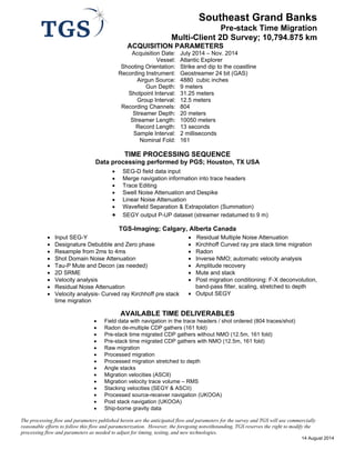
Southeast Grand Banks 2015
Pre-stack Time Migration
Multi-Client 2D Survey; 14,599 km
2. 48°W
48°W
54°W
54°W48°N
48°N
42°N
42°N
SOUTHEAST GRAND BANKS 2015
MULTI-CLIENT 2D SEISMIC SURVEY
0 50 100 150 20025
Kilometers
N:PublicGISArc Map DocumentsCanadaSpecSheetMapsSE Grand Bank_Spec(Port)_updated.mxd March 22, 2016
2016 Planned
2015: 14,599.375 km
2014: 10,678.625 km
NEWFOUNDLAND